4-20-02
Nearly every Spring I set out to climb to the top of Iron Peak which is located up the North Fork of the Teanaway River. I usually do it after the road has melted out to within a mile or less of the trailhead. The route follows Beverly Creek on the right side from the trailhead to near the end of the basin. It then crosses the creek and ascends to a pass between Iron and Teanaway Peaks. From there it follows the ridge to the top of Iron Peak. In the Spring the trail is often buried with snow from the trailhead to the summit. By following the creek and then crossing it and going straight up the ridge near the summit it requires nearly no route finding. The return begins with a 500' glissade off of the summit ridge. There is a good run out at the bottom. I wanted to try an early attempt this year.
I called the Cle Elum Ranger Station on Thursday and was told the road was not passable much past the end of the winter plowing at 29 Pines Campgrounds. From there to the summit of Iron is nearly 18 miles round trip. I doubted that I could do that distance on snow but I wanted to check out the conditions in the area. Even if I couldn't reach the summit, it is beautiful in the Beverly Creek valley. The only hope to reach the summit alone would be with near perfect conditions. Saturday was forecast to be 65 in Ellensburg with partial clouds over the eastern slopes of the mountains. In the morning the snow would be very firm but it would soften in the afternoon and be much more difficult to travel on. Taking this into account, I woke up at 4:40 and left my house at 5:35. By 7:25 I was at the end of the winter plowing and there was no snow in sight. I followed the dirt road until snow was on the road. beyond this point the road drops into a shaded area which melts out later than the area before and after. I parked 8/10ths of a mile beyond the end of pavement. That reduced the total round trip distance to the summit by over 1 1/2 miles. Things were looking up. Now it would "only" be 16 miles.
I was on my way at 7:38. It was still quite cold. The snow on the road was solid ice. My boots barely left a mark. The car was at 2700' and the summit is 6520'. With the snow so hard it was easy to make good time. In only 50 minutes I was 3 1/4 miles along at the Beverly Creek Bridge. A road turns off to the right and ascends 1 1/4 miles to the Summer trailhead. After over 3 nearly flat miles the route began to head higher. The trailhead still has about 2-3 feet of snow. I crossed the bridge over Beverly Creek and continued on to the road/trail end at Bean Creek. Crossing the creek can be a real challenge in the Spring. Sometimes there is a snow bridge and sometimes there is just a raging torrent. This time there was neither. I took off my boots and put on wet suit boots which I carry in the Spring for difficult creek crossings. I did not want to have wet feet and soaked boots with so much farther to go. The wet suit boots worked great as I walked right across the creek. The snow was deep enough to require kicking steps down to the water. The first 5 miles to the creek gained 1300' The next 3 miles would gain another 2400'. The last mile would be 1300'. After crossing the creek I put on snowshoes. The road was packed down by snowmobiles. The rest of the way was untouched. Speaking of untouched, from the creek on there were no signs of any people. I saw no footprints at all. One of the nice benefits of early season trips is the completely untouched snow. I managed to weave through the forest with no problems. I was occasionally on the real trail but it really does not matter. The route eventually left the trees and entered the lower basin. Now there were large open areas between the trees. I kept near the creek all the way. The Summer trail switchbacks up the slope but with a deep snow cover it really did not matter.
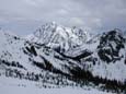
Crossing Beverly Creek can be a problem. In the Spring the snow is deep enough to make it difficult to climb down to the creek and get across. Snow bridges are the best way but often are not very strong. This year I was early enough to have no trouble at all. The snow was very thick on top of the creek. I poked with a pole but could ot even dent the snow. I crossed farther down than I had ever been able to before. From here it is just a long steep slog up the mountain. I continued up almost directly below the summit. When I reached the base of the last steep climb to the summit ridge I stopped to plan the best place. Much of the ridge is heavily corniced. I needed to find a spot without this problem. Just to the right of the summit there is a very steep slope with no cornices. Still with my MSR snowshoes on, I headed straight up. My altimeter placed me at 5900', only 600' below the summit. There had not been a cloud in the sky all morning and now the heat really took over. I had sweat running into my eyes constantly. I had not felt this hot in about 6 months. The snow had been nearly perfect all day. Most of the last climb was great. With about 100' to go there was a hard crust under about 6 inches of snow. It was hard to get the snowshoes to "bite" through the snow into the ice. I kept sliding a few feet back. The last 100' must have taken 5 minutes. It seemed like twenty. Upon reaching the ridge top the view to the West opened up. Stuart, Teanaway, Bill, Mary, and Volcanic Neck were there on the way up. At the top I would see Rainier, Three Queens, Daniel, Cathedral Rock, Hawkins, Esmerelda, Fortune, Ingalls, South Ingalls, and many more. About now the clouds rolled in and blocked the sun. The temperature dropped immediately. I trudged the last 150 feet to the summit and put on more clothes. I dropped down 10 feet to the West near some exposed rocks and started digging. Much to my surprise, I found the summit register. I signed in, had lunch, and started taking photos. I reached the top at 12:03, just in time for lunch. It took 4:26 to cover the 8 miles to the top. If the snow was much softer I could never have done it alone.
The biggest disappointment of the day was at the beginning of the trip down. The snow over ice did not give me a good feeling about glissading down. Instead I packed up the snowshoes and plunge stepped down the first 600'. This is the only time I have climbed Iron in the Spring and not glissaded down the ridge. I'll just have to wait until next year. The snow was softer coming out but there was still no problem snowshoeing. Instead of sinking in an inch as on the way up I now sank 2-4 inches. Even on the sun warned snow the conditions were very good. The trip out was very long. I left the summit at 12:50 and finally reached the car at 4:28. It took exactly 9 hours round trip. I saw a grand total of 10 elk on the drive in and zero people the whole day. Who says there is no solitude left in the mountains?
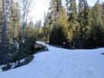
Beverly Bridge |
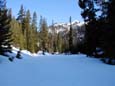
Summer Trailhead |
Trail Starts Here |
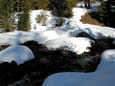
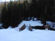
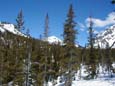
Bean Creek |
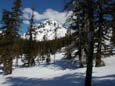
Bill Peak |
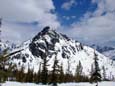
Teanaway Peak |
Bill Peak Again |
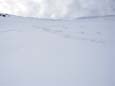
Route To The Ridge |
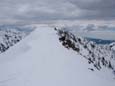
Iron Summit |
Stuart From Iron |
Photos Page 2