7-28-02
I first hiked the trail up Mount
Aix in 1990. It was part of a two day car camping/hiking weekend in the
Bumping Lake area. I had such a good time that I did it again in 1991. Somehow
this trip dropped off my radar screen and only reemerged this weekend. Gary
and I had kicked around several different destinations depending on the
weather. With the forecast deteriorating we scrapped them all on Saturday
evening in favor of Mount Aix. While it had been 11 years since I last hiked
the trail, Gary never had. He had been to the summit over 20 years earlier
but it was by a different route. Mount Aix lies directly east of Mount Rainier
on the east side of the Cascade crest. We hoped that this eastern location
would shield us from clouds and drizzle. We were half right.
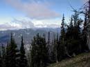
It's a long drive from Seattle. I left home at 6:10 and met Gary in Kent at 6:40. By 6:45 we were on the road. At that hour on a Sunday the traffic was very light. We reached the trailhead at 8:40. There was one car there already. Another drove up just as we left. By 8:50 we were on our way. The trail is just as nice as I remembered it. If there is such a thing as a gently graded trail which gains 4000' this is it. A short way up is a washout that buried part of the trail. There are a few cairns marking the way through. That pretty much covers the problems all the way up to the ridge top. There was one tree down but we went right under it. This trail starts in forest with some good sized trees. As you gain elevation the forest thins. For the most part the trail is a series of long switchbacks. None are very steep and most are fairly long. The weather began partly cloudy and as we rose Mt. Rainier peaked out from behind the ridge to the west. There were some clouds around the mountain but it was mostly clear. As we rose the clouds thickened.
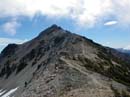
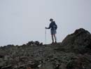
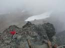
The previous day I helped a friend work on his lakeside cabin/house/mansion (a 3700 sq ft cabin??) and I was still feeling the effects. We put down 900 square feet of floor boards held in place with 1400 screws. I was standing and kneeling for over 6 hours and it overworked muscles I didn't know I had. I can hike day after day with no pain but for the first time in a long while my legs ached. Still, you only get so many long summer day to hike so I had to go. At about 4 miles we caught up with the early bird hikers. It took about 3 seconds for Gary and one of the other hikers to recognize each other. Gary had only seen Sally once on the trail in the past 8-9 years. You never know who you will meet on the trail. We continued on ahead as the forest gave way to sub alpine terrain. More and more flowers appeared and the views would have been great except for the the clouds. I kept looking for Bismark Mountain but the upper 1000' were already in the clouds. Mount Rainier was long gone as well. We reached Nelson Ridge at about 7100'. The fairly calm trip we had had so far changed immediately. The wind on the ridge top was very strong. We dropped over the east side to get out of it for a minute. It had been quite warm at the trailhead but it was getting chilly on the ridge. After food, water, and some more clothes we were back on our way. The trail continues just below the ridge top and the wind was not so bad here. The trail goes south towards Bismark then turns to the east and aims for Aix. As the summit came into view it was in and out of the clouds. Gary made a good suggestion here and we both took several photos of the summit. It would be the only time we saw it from a distance all day. The trail then drops down and begins the final approach to Mt. Aix. The real trail goes below the summit and traverses to the ridge beyond. Someone had blocked the trail with rocks leaving the apparent route straight up a scramble route to the summit. I normally love a scramble but with the way my legs felt I suggested taking the real trail. The next section can barely be called a trail. It traverses a dirt and scree field. In several places slides have obliterated short sections. In most places the route is sketchy but easily followed. Unless you like to scramble I would recommend the traverse route.
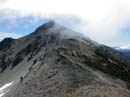
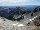
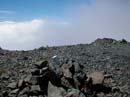
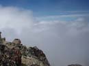
After reaching the ridge beyond the summit the route turns upward and climbs to a point where it crosses the ridge. The backside route is in better shape. The route splits with one trail going over to the only snowfield still existing. The easier route drops down to the bottom of the snow and goes around it. From there it is an easy hike up to the summit. When we reached the top the view to the east was marginal and the other directions were nonexistent. I felt pretty good except for the fact that I could barely bend my knees. Gee, and only a little over 4000' to descend. Thankfully the trail is smooth and gently graded. We spent about 30 seconds on the wind blown summit and dropped just below to the east to escape the wind. It was interesting to be near the top of the clouds. It was very similar to being in an airplane. More clouds blew in and cut off the views in all directions. It was supposed to be 88 degrees in Yakima, about 45 miles away, but it was frigid on the summit. The two hikers we passed arrived shortly and the person from the car arriving as we started arrived a little later. We spent a full hour before heading down. Going down we detoured to the snowfield for some standing glissading. It was a quick way to avoid some knee pounding and have some fun to boot. My standing glissade accidentally became a sitting glissade but was still lots of fun. We crossed the ridge and traversed back to under the summit. Here we removed the rock barrier to the real trail. Now you have your choice of a steep or a not so steep route to the top. The rest of the way down was a little painful on the legs but not too bad. We only saw a couple of other people the rest of the way. The clouds never lifted but the rain never came. I will take those conditions any time. All totaled we hiked 12 miles and gained 4300' with ups and downs. The trailhead is at 3700' and the summit is 7766'. Although this hike is near Mosquito Meadows and the Tumac Plateau we had almost no bugs at all. After returning to this fine trail I will make sure not to wait 11 years to come back.
Click on thumbnails to get larger pictures.
Photo Page 2
Home
It's a long drive from Seattle. I left home at 6:10 and met Gary in Kent at 6:40. By 6:45 we were on the road. At that hour on a Sunday the traffic was very light. We reached the trailhead at 8:40. There was one car there already. Another drove up just as we left. By 8:50 we were on our way. The trail is just as nice as I remembered it. If there is such a thing as a gently graded trail which gains 4000' this is it. A short way up is a washout that buried part of the trail. There are a few cairns marking the way through. That pretty much covers the problems all the way up to the ridge top. There was one tree down but we went right under it. This trail starts in forest with some good sized trees. As you gain elevation the forest thins. For the most part the trail is a series of long switchbacks. None are very steep and most are fairly long. The weather began partly cloudy and as we rose Mt. Rainier peaked out from behind the ridge to the west. There were some clouds around the mountain but it was mostly clear. As we rose the clouds thickened.
The previous day I helped a friend work on his lakeside cabin/house/mansion (a 3700 sq ft cabin??) and I was still feeling the effects. We put down 900 square feet of floor boards held in place with 1400 screws. I was standing and kneeling for over 6 hours and it overworked muscles I didn't know I had. I can hike day after day with no pain but for the first time in a long while my legs ached. Still, you only get so many long summer day to hike so I had to go. At about 4 miles we caught up with the early bird hikers. It took about 3 seconds for Gary and one of the other hikers to recognize each other. Gary had only seen Sally once on the trail in the past 8-9 years. You never know who you will meet on the trail. We continued on ahead as the forest gave way to sub alpine terrain. More and more flowers appeared and the views would have been great except for the the clouds. I kept looking for Bismark Mountain but the upper 1000' were already in the clouds. Mount Rainier was long gone as well. We reached Nelson Ridge at about 7100'. The fairly calm trip we had had so far changed immediately. The wind on the ridge top was very strong. We dropped over the east side to get out of it for a minute. It had been quite warm at the trailhead but it was getting chilly on the ridge. After food, water, and some more clothes we were back on our way. The trail continues just below the ridge top and the wind was not so bad here. The trail goes south towards Bismark then turns to the east and aims for Aix. As the summit came into view it was in and out of the clouds. Gary made a good suggestion here and we both took several photos of the summit. It would be the only time we saw it from a distance all day. The trail then drops down and begins the final approach to Mt. Aix. The real trail goes below the summit and traverses to the ridge beyond. Someone had blocked the trail with rocks leaving the apparent route straight up a scramble route to the summit. I normally love a scramble but with the way my legs felt I suggested taking the real trail. The next section can barely be called a trail. It traverses a dirt and scree field. In several places slides have obliterated short sections. In most places the route is sketchy but easily followed. Unless you like to scramble I would recommend the traverse route.
After reaching the ridge beyond the summit the route turns upward and climbs to a point where it crosses the ridge. The backside route is in better shape. The route splits with one trail going over to the only snowfield still existing. The easier route drops down to the bottom of the snow and goes around it. From there it is an easy hike up to the summit. When we reached the top the view to the east was marginal and the other directions were nonexistent. I felt pretty good except for the fact that I could barely bend my knees. Gee, and only a little over 4000' to descend. Thankfully the trail is smooth and gently graded. We spent about 30 seconds on the wind blown summit and dropped just below to the east to escape the wind. It was interesting to be near the top of the clouds. It was very similar to being in an airplane. More clouds blew in and cut off the views in all directions. It was supposed to be 88 degrees in Yakima, about 45 miles away, but it was frigid on the summit. The two hikers we passed arrived shortly and the person from the car arriving as we started arrived a little later. We spent a full hour before heading down. Going down we detoured to the snowfield for some standing glissading. It was a quick way to avoid some knee pounding and have some fun to boot. My standing glissade accidentally became a sitting glissade but was still lots of fun. We crossed the ridge and traversed back to under the summit. Here we removed the rock barrier to the real trail. Now you have your choice of a steep or a not so steep route to the top. The rest of the way down was a little painful on the legs but not too bad. We only saw a couple of other people the rest of the way. The clouds never lifted but the rain never came. I will take those conditions any time. All totaled we hiked 12 miles and gained 4300' with ups and downs. The trailhead is at 3700' and the summit is 7766'. Although this hike is near Mosquito Meadows and the Tumac Plateau we had almost no bugs at all. After returning to this fine trail I will make sure not to wait 11 years to come back.
Mt. Rainier |
Summit of Mt. Aix |
Summit In Clouds |
View East |
Gary On The Summit |
Summit Register |
Cloud Tops |
Hiker Below Summit |
Photo Page 2
Home