9-28-02
Last year I hiked up Mt. David.
It had been on my "to do" list for a decade. On the last Sunday of September
I had a beautiful sunny day. The only problem is that I did not take a camera.
Do not ever put in this much effort to reach a fantastic summit and forget
your camera. I knew I needed to return. I also knew my hiking partner Gary
would love this trip. With that in mind, we blocked out the last Saturday
in September to make this trip. The weather gods were smiling as we had
a mostly sunny day. My luck held out two years in a row.
We headed out of town on Friday night in Gary's camper van. By the time we reached Lake Wenatchee it was dark. At the trailhead it was pitch black. The view of the Milky Way was something that cannot be seen near the lights of the city. Sleeping indoors with the van made the camping part of the trip a snap. By 7:20 in the morning we were on the trail. After crossing the big new bridge we turned left and hiked down river, losing about 100' in the first mile. After passing the abandoned Painter Creek trail the route starts to climb. At first the trail alternates between steep switchbacks and flatter sections. When it finally begins to climb the ridge it does not relent until the ridge top is reached. The first 4 1/2 miles is one of the nicest trails I have hiked. After the first 100 descent the trail climbs 3200' in 3 1/2 miles. The grade is very even and never overly steep. I found it easier than many trails with less daunting distance and elevation numbers. It was fairly cool when we began but warmed up quickly. We reached the ridge top in just under two hours.
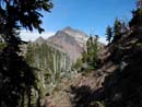
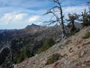
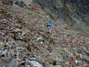
The last 3 1/2 miles to the summit is alpine ridge running at it's best. The route winds around knobs and returns to the ridge. It descends across talus slopes and switchbacks up again. It switchbacks up a steep gully on narrow but quite good tread. The berries were a little disappointing although there were a few good patches left. The leaves are turning and some sections had very good colors. At first Clark Mountain dominated the views. As we ascended, Mt. Maude and 7 Fingered Jack came into view. Lake Wenatchee and Dirtyface Peak also were visible. After reaching the ridge top, Mt. Whittier and Nason Ridge are seen. Higher up, Mt. Daniel, Hinman, and then Stuart are to the south. Last year I encountered one snow patch on the trail on a north facing slope below the summit. With more snow this past winter I was expecting a little more snow. Instead, there was some snow but none near the trail. We reached the ridge top again just below the summit and headed up the final section. This is the only scramble part and it is not very difficult. At several points the trail seems to disappear but there are cairns to redirect you. The last part is the "ledge" where a route was cut out of the rock. This is a little narrow and exposed but not hard unless you have a real fear of heights. In fact, this whole route is probably not good if you do. Most hikers who have the determination to gut out this whole trip should have no trouble with the last part.
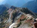
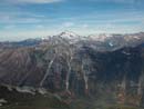
When you crest the summit the whole view to the north and west pops out at you. Glacier Peak is right in front. This is one of the best views of Glacier I have ever had. Sloan Peak and the Monte Cristo Peaks are close at hand. Three Fingers and Whitehorse are easy to spot. We pulled out a large area map and spent quite awhile identifying the myriad peaks. After lunch I led Gary over to the David Igloo, or loo, for short. It is an outhouse built out of many small rocks piled up just like an igloo. The door is missing but otherwise it's in good shape. Two steps from the door there is a 1000'+ vertical cliff. This has my vote for the best outhouse in the state. With our early start time was not much of a factor. We were able to spend a full two hours on the summit. The sun was still out but at 7430" it was a bit chilly. The way down was long but nice. I was startled to pass two hikers coming up high on the ridge at about 4:00. They had full packs and were going to spend the night on the summit. Considering that the snow level was forecast to drop all the way down to 4,000' over night, I thought they were crazy. I hope they enjoyed their freezing trip back down. Those two were the only people we saw on the trail all day. This is a great trip if you are in good shape. The total distance is 16 miles and the elevation gain, with ups and downs, is about 5700'. Gary took a short detour and he ended up with 6000' for the day. After trips in consecutive years I'll leave David alone for awhile but I will be back.
Click on thumbnails to get larger pictures.
Photo Page 2
Home
We headed out of town on Friday night in Gary's camper van. By the time we reached Lake Wenatchee it was dark. At the trailhead it was pitch black. The view of the Milky Way was something that cannot be seen near the lights of the city. Sleeping indoors with the van made the camping part of the trip a snap. By 7:20 in the morning we were on the trail. After crossing the big new bridge we turned left and hiked down river, losing about 100' in the first mile. After passing the abandoned Painter Creek trail the route starts to climb. At first the trail alternates between steep switchbacks and flatter sections. When it finally begins to climb the ridge it does not relent until the ridge top is reached. The first 4 1/2 miles is one of the nicest trails I have hiked. After the first 100 descent the trail climbs 3200' in 3 1/2 miles. The grade is very even and never overly steep. I found it easier than many trails with less daunting distance and elevation numbers. It was fairly cool when we began but warmed up quickly. We reached the ridge top in just under two hours.
The last 3 1/2 miles to the summit is alpine ridge running at it's best. The route winds around knobs and returns to the ridge. It descends across talus slopes and switchbacks up again. It switchbacks up a steep gully on narrow but quite good tread. The berries were a little disappointing although there were a few good patches left. The leaves are turning and some sections had very good colors. At first Clark Mountain dominated the views. As we ascended, Mt. Maude and 7 Fingered Jack came into view. Lake Wenatchee and Dirtyface Peak also were visible. After reaching the ridge top, Mt. Whittier and Nason Ridge are seen. Higher up, Mt. Daniel, Hinman, and then Stuart are to the south. Last year I encountered one snow patch on the trail on a north facing slope below the summit. With more snow this past winter I was expecting a little more snow. Instead, there was some snow but none near the trail. We reached the ridge top again just below the summit and headed up the final section. This is the only scramble part and it is not very difficult. At several points the trail seems to disappear but there are cairns to redirect you. The last part is the "ledge" where a route was cut out of the rock. This is a little narrow and exposed but not hard unless you have a real fear of heights. In fact, this whole route is probably not good if you do. Most hikers who have the determination to gut out this whole trip should have no trouble with the last part.
When you crest the summit the whole view to the north and west pops out at you. Glacier Peak is right in front. This is one of the best views of Glacier I have ever had. Sloan Peak and the Monte Cristo Peaks are close at hand. Three Fingers and Whitehorse are easy to spot. We pulled out a large area map and spent quite awhile identifying the myriad peaks. After lunch I led Gary over to the David Igloo, or loo, for short. It is an outhouse built out of many small rocks piled up just like an igloo. The door is missing but otherwise it's in good shape. Two steps from the door there is a 1000'+ vertical cliff. This has my vote for the best outhouse in the state. With our early start time was not much of a factor. We were able to spend a full two hours on the summit. The sun was still out but at 7430" it was a bit chilly. The way down was long but nice. I was startled to pass two hikers coming up high on the ridge at about 4:00. They had full packs and were going to spend the night on the summit. Considering that the snow level was forecast to drop all the way down to 4,000' over night, I thought they were crazy. I hope they enjoyed their freezing trip back down. Those two were the only people we saw on the trail all day. This is a great trip if you are in good shape. The total distance is 16 miles and the elevation gain, with ups and downs, is about 5700'. Gary took a short detour and he ended up with 6000' for the day. After trips in consecutive years I'll leave David alone for awhile but I will be back.
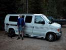
Van At Trailhead |
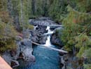
White River |
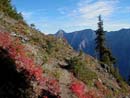
Fall Colors |
Summit |
Whittier Peak |
Trail Below |
Trail, What Trail? |
Glacier Peak |
Photo Page 2
Home