5-04-02
My friend Gary had Saturday free
so we spent several days checking the weather to figure out where to go for
the best conditions. The forecast kept deteriorating with bad weather coming
in for the west side and clouds and high winds forecast for the east side.
What's a hiker to do? By Friday evening we eliminated Umtanum Ridge (Nasty
with 30 mph winds.) and anything near the crest. We tentatively planned for
a trip up Sasse Mountain. I have done Jolly Mountain in the summer and Hex
Mountain in the winter but never Sasse. All three peaks lie along or near
Sasse Ridge which is the eastern side of the Cle Elum River valley. Gary had
done it, but it was many years before. We met in Issaquah early Saturday morning
and I drove as we headed east. The weather was lousy on the western slopes
and cold but better on the east slopes. Beyond Easton the clouds became lighter
but did not go away. The old Sasse Mountain trail has been obliterated by
logging. It does still show up on a map Gary has. There is a road that goes
high up on the ridge but we planned to scramble up, hopefully finding some
of the old trail.
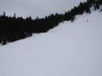
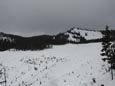
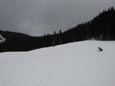
We parked on a dirt road that goes off just after Little Salmon La Sac Creek. In fact, I had to drive through one small part of the creek. The map showed the old trail paralleling the creek on the left bank for several hundred vertical feet then crossing. We followed the dirt road up and hoped to find a trail. The road ended soon and we did find a small part of trail but it was going downhill. We headed towards the creek and a place to cross. The thick underbrush was just a taste of what we would wander into near the end of this trip. At the creek there was an old log across that seemed marginally OK to me but Gary was not impressed. I crossed it then lost track of Gary when we headed upstream to find a better place. I don't know how he did it but several minutes later we were both across. The other side of the creek was a clearcut with lots of brush. Up a steep slope the clearcut ended and forest began. Up to this point there was virtually no snow. We beat the brush up into the forest and things were much better. Now we had a moderately steep slope with good footing to scramble. Before too much longer the snow began. The trailhead was at 2300' and I believe we hit snow at about 2700'. We kept to the right of the creek and continued climbing higher. The snow was softer than I expected since the night had been below freezing. Being fairly big guys with heavy packs we began to posthole. The snow was not consistent enough to put on the snowshoes yet as we went from snow to dirt and back to snow again. Finally we came out of the forest into more open terrain and there was enough snow to put on the snowshoes. We were a little disheartened to see that the conditions had really slowed us down. We felt that we were well up the mountain but had only climbed 1400'. We still had 2000' to go. With better snow and snowshoes things were better. We intersected one spur road then the main road. We were able to see a large steep clearcut from the car and were now just at the base of it. From here we left the road and headed straight up. We aimed for the left side of the clearcut where the grade was less precipitous. In the next 20 minutes we ground out about 900' of elevation gain. This raised our spirits and we began to feel better. At the top of the clearcut the grade eased and we intersected what I believe is the beginning of what's left of the trail. We were on the right side of a huge bowl that forms the headwaters of the creek. At the end of the bowl is a steep slope rising to the top of Sasse Ridge. On the right is an unnamed peak and to the left of it the ridge rises up to the summit of Sasse.
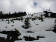
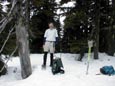
We spent some time studying the map and trying to figure out the best way to get to the top of the ridge. Much of the final slope was in trees and it was difficult from a distance to judge the slope. The unnamed summit had open slopes but they were very steep. Gary felt the best hope of attaining the ridge was to go to the left of the unnamed peak and right up the head of the bowl. We headed up on wide open snow-covered terrain at an easy angle. We traversed around the head of the basin and turned right up the slope. The snow was fairly firm so we had good "grip" with our snowshoes. For the last section we headed into the trees and climbed toward the ridge top. Thankfully the snow was firm but not icy. The last thing I wanted to do was slip and bash into a tree. The route proved good and we topped out on the ridge crest. The best news is that the ridge was plenty wide enough to safely ascend. The ridge headed steeply up on our right to the summit of the unnamed peak. If the weather was better it would make a good scramble. It has few trees on top and would afford you great views. We turned to the left and ascended a more moderate grade towards the summit of Sasse. We wound around trees even on the ridge top at 5400'. In short order we were up on the summit of Sasse, elevation 5730'. I was surprised to find that the summit is heavily forested. This was not such a bad thing on this day as the trees minimized the wind. My thermometer read 35 degrees and it began to lightly snow. We sat down to lunch and spent about 25 minutes on top.
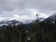
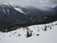
After lunch it was time to head on down. The first section down to where we reached the ridge went very fast. The next section had me a little worried. The descent through the trees was very steep. I was worried about traction heading down. In fact, the snow was a little softer and the descent was a breeze. We charged down the slope and began the long contour around the head of the basin. It was still cloudy but Kachess Ridge made for nice scenery as we came down. Back at the top of the clearcut we found the end of the logging road that came up from the valley floor. We had crossed it at a steep angle and never noticed it on the way up. The choices were to down climb the clearcut or take the longer but much easier road to the base of the clearcut. We chose the latter and had an easy road walk to lose those 900'. At that point we followed the road a short distance to where we had originally intersected it while coming up. We then plunged off road and headed straight down. When we hit the lower spur we followed it and met back up with the main logging road. We then followed it much of the way down. Of course, the road would have been the easiest way to get back to the valley floor but not the most adventurous. When the snow became sporadic we took off the snowshoes and left the road. The route was straight down the hillside. The contour map showed a moderate slope down from here. In several places we had cliffs to the left and cliffs to the right but a route would miraculously cut right between them. I was amazed at how well it went. We finally intersected the road one more time. After following it a ways we left it for good and headed in the direction of the creek and the car. This turned out to be a bit of a mistake. We ended up in a morass of brush with branches blocking every direction. The last quarter mile was a battle. I was elated to see the main valley road as we thrashed our way out of the thicket. A short walk along the road and we were back at the car.
This was a great trip. We saw no other people all day long. The terrain and route finding were challenging. The high winds forecast never materialized. The only precipitation was in the form of light snow. Best of all, I was able to scramble to the top of this peak for the first time. We never did find any sign of the old trail. I'm afraid it's gone for good.
Click thumbnails to get larger pictures.
Photo Page 2
Home
We parked on a dirt road that goes off just after Little Salmon La Sac Creek. In fact, I had to drive through one small part of the creek. The map showed the old trail paralleling the creek on the left bank for several hundred vertical feet then crossing. We followed the dirt road up and hoped to find a trail. The road ended soon and we did find a small part of trail but it was going downhill. We headed towards the creek and a place to cross. The thick underbrush was just a taste of what we would wander into near the end of this trip. At the creek there was an old log across that seemed marginally OK to me but Gary was not impressed. I crossed it then lost track of Gary when we headed upstream to find a better place. I don't know how he did it but several minutes later we were both across. The other side of the creek was a clearcut with lots of brush. Up a steep slope the clearcut ended and forest began. Up to this point there was virtually no snow. We beat the brush up into the forest and things were much better. Now we had a moderately steep slope with good footing to scramble. Before too much longer the snow began. The trailhead was at 2300' and I believe we hit snow at about 2700'. We kept to the right of the creek and continued climbing higher. The snow was softer than I expected since the night had been below freezing. Being fairly big guys with heavy packs we began to posthole. The snow was not consistent enough to put on the snowshoes yet as we went from snow to dirt and back to snow again. Finally we came out of the forest into more open terrain and there was enough snow to put on the snowshoes. We were a little disheartened to see that the conditions had really slowed us down. We felt that we were well up the mountain but had only climbed 1400'. We still had 2000' to go. With better snow and snowshoes things were better. We intersected one spur road then the main road. We were able to see a large steep clearcut from the car and were now just at the base of it. From here we left the road and headed straight up. We aimed for the left side of the clearcut where the grade was less precipitous. In the next 20 minutes we ground out about 900' of elevation gain. This raised our spirits and we began to feel better. At the top of the clearcut the grade eased and we intersected what I believe is the beginning of what's left of the trail. We were on the right side of a huge bowl that forms the headwaters of the creek. At the end of the bowl is a steep slope rising to the top of Sasse Ridge. On the right is an unnamed peak and to the left of it the ridge rises up to the summit of Sasse.
We spent some time studying the map and trying to figure out the best way to get to the top of the ridge. Much of the final slope was in trees and it was difficult from a distance to judge the slope. The unnamed summit had open slopes but they were very steep. Gary felt the best hope of attaining the ridge was to go to the left of the unnamed peak and right up the head of the bowl. We headed up on wide open snow-covered terrain at an easy angle. We traversed around the head of the basin and turned right up the slope. The snow was fairly firm so we had good "grip" with our snowshoes. For the last section we headed into the trees and climbed toward the ridge top. Thankfully the snow was firm but not icy. The last thing I wanted to do was slip and bash into a tree. The route proved good and we topped out on the ridge crest. The best news is that the ridge was plenty wide enough to safely ascend. The ridge headed steeply up on our right to the summit of the unnamed peak. If the weather was better it would make a good scramble. It has few trees on top and would afford you great views. We turned to the left and ascended a more moderate grade towards the summit of Sasse. We wound around trees even on the ridge top at 5400'. In short order we were up on the summit of Sasse, elevation 5730'. I was surprised to find that the summit is heavily forested. This was not such a bad thing on this day as the trees minimized the wind. My thermometer read 35 degrees and it began to lightly snow. We sat down to lunch and spent about 25 minutes on top.
After lunch it was time to head on down. The first section down to where we reached the ridge went very fast. The next section had me a little worried. The descent through the trees was very steep. I was worried about traction heading down. In fact, the snow was a little softer and the descent was a breeze. We charged down the slope and began the long contour around the head of the basin. It was still cloudy but Kachess Ridge made for nice scenery as we came down. Back at the top of the clearcut we found the end of the logging road that came up from the valley floor. We had crossed it at a steep angle and never noticed it on the way up. The choices were to down climb the clearcut or take the longer but much easier road to the base of the clearcut. We chose the latter and had an easy road walk to lose those 900'. At that point we followed the road a short distance to where we had originally intersected it while coming up. We then plunged off road and headed straight down. When we hit the lower spur we followed it and met back up with the main logging road. We then followed it much of the way down. Of course, the road would have been the easiest way to get back to the valley floor but not the most adventurous. When the snow became sporadic we took off the snowshoes and left the road. The route was straight down the hillside. The contour map showed a moderate slope down from here. In several places we had cliffs to the left and cliffs to the right but a route would miraculously cut right between them. I was amazed at how well it went. We finally intersected the road one more time. After following it a ways we left it for good and headed in the direction of the creek and the car. This turned out to be a bit of a mistake. We ended up in a morass of brush with branches blocking every direction. The last quarter mile was a battle. I was elated to see the main valley road as we thrashed our way out of the thicket. A short walk along the road and we were back at the car.
This was a great trip. We saw no other people all day long. The terrain and route finding were challenging. The high winds forecast never materialized. The only precipitation was in the form of light snow. Best of all, I was able to scramble to the top of this peak for the first time. We never did find any sign of the old trail. I'm afraid it's gone for good.
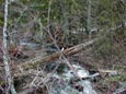
Crossing The Creek |
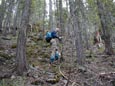
What Trail? |
Thorp Mountain |
Steep Clearcut |
Upper Basin |
Valley View |
Unnamed Peak |
Nearing The Ridge |
Jim On The Summit |
Photo Page 2
Home