7-14-02
Shriner Peak is one of those trails
that I have known about for years but I never actually went out and hiked
it. My friend Gary has done it many times and we have talked about doing it
together on several occasions. This day we had planned on going over to the
Olympics and hiking up Mt. Jupiter. The weather report had been turning more
negative in the preceding 24 hours and we didn't want to go that far and
not have a view. At 9:15 Saturday night we finally connected and decided to
find an alternative to Jupiter. The forecast was for morning drizzle and some
afternoon clearing. At that point Gary came up with Shriner Peak and since
I had not done it I agreed. There might not be any view but at least I would
have a new summit.
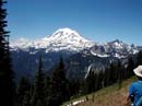
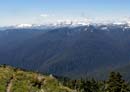
We met in Kent at 7:00 and were at the trailhead, 7 1/2 miles south of Cayuse Pass, by 8:30. The roadside parking area is exactly opposite the mile 9 sign. By the time you see the trail sign you have passed the parking. The trail starts just down the road. Most of the drive from Cayuse was in thick fog. By the trailhead we were below it. There was no drizzle but it was not clear either. The trail is very nicely constructed. It starts out at a Mt. Si like 800' per mile pace. After one quick switchback it begins a very long traverse to the south. The trail is very smooth and a real joy to hike. The first section is in the forest. After the heat of the day before at Esmerelda the cool morning was much appreciated by me. We were quite surprised to see 6 other cars on an overcast morning at 8:30am. As we proceeded higher we passed most of the other early birds. After gaining about 2000' we reached a very short side trail to a great view of Mt. Rainier. Someone else beat us to this viewpoint. From the trail Rainier was now visible as well. The lower mountain was in the clouds but the upper section seemed to float above the clouds. By now the clouds were rapidly vanishing. The weather forecasters struck again as we were on our way to a very sunny day. Once out of the trees the trail climbs a hillside blanketed with wildflowers. We saw the usual paintbrush, and lupine but also tiger lilies, columbine, glacier lilies, avalanche lilies, and lots of beargrass. We passes a second group then a third and a fourth. At about 4900' we encountered snow. At first it was just a few small patches. As we entered forest it became thicker. We lost the trail and rather than hunt for it we headed straight up. The actual trail turned to the left and exited the forest. At that point it returned to dirt all the way to the top. We found this out on our way down. The rest of the way up was much more interesting. We soon reached a ridge and followed it up. Sometimes on snow and sometimes on dirt we kept climbing. Much of the way off snow was following game trails. The animals don't seem to have any problem getting around the peak. We climbed over 400' off trail and eventually reached the summit. By now there were only a few small clouds below Rainier. Otherwise, the sky was completely clear. With our little detour and a number of stops to take pictures, it took just over 2 hours to reach the top. The distance and elevation are nearly identical to Mt. Si but the scenery is one heck of a lot better. Mt. Rainier is enormous from Shriner.
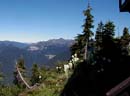
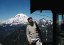
We put on dry shirts poured on the sun screen and sat down to an early (10:45) lunch. Beargrass grows all around the summit. Most of the other wildflowers are here too. The lookout is locked but you can climb the stairs and walk all the way around it. We pulled out maps and the binoculars and spent quite awhile picking out all the summits around Mt. Rainier. Little Tahoma is directly in line with Rainier and at first I didn't even recognize it as a separate peak. The Tatoosh Range is fully visible to your left. To the right we could see the trail up Fremont Lookout. We identified Tamanos, Barrier, The Cowlitz Chimneys, Mt. Ruth, and Steamboat Prow. We also saw numerous rope teams coming down the Emmons Glacier at about 12000'. The whole east side of Mt. Rainier is laid out before you. On top it was warm but not hot, there was a gently breeze, and the bugs were not much of a bother. All in all, it was nearly perfect. There were 2 hikers on top when we arrived. They left and the next group arrived after about an hour. We spent 2 full hours on the summit. I really did not want to leave. At 12:45 we packed up and headed down. The trip down was no problem. As stated earlier, the trail down to the snow in the trees is bare. After the short section on snow we were back on dirt for the rest of the way down. It's 4.2 miles and 3400' to the top. With our shortcut we probably did about 8 miles round trip. This a spectacular hike on a clear day. Our timing was great. The snow was nearly gone and the wildflowers were near their peak. I will definitely be back to Shriner Peak before long.
Click on thumbnails to get larger pictures.
Photo Page 2
Home
We met in Kent at 7:00 and were at the trailhead, 7 1/2 miles south of Cayuse Pass, by 8:30. The roadside parking area is exactly opposite the mile 9 sign. By the time you see the trail sign you have passed the parking. The trail starts just down the road. Most of the drive from Cayuse was in thick fog. By the trailhead we were below it. There was no drizzle but it was not clear either. The trail is very nicely constructed. It starts out at a Mt. Si like 800' per mile pace. After one quick switchback it begins a very long traverse to the south. The trail is very smooth and a real joy to hike. The first section is in the forest. After the heat of the day before at Esmerelda the cool morning was much appreciated by me. We were quite surprised to see 6 other cars on an overcast morning at 8:30am. As we proceeded higher we passed most of the other early birds. After gaining about 2000' we reached a very short side trail to a great view of Mt. Rainier. Someone else beat us to this viewpoint. From the trail Rainier was now visible as well. The lower mountain was in the clouds but the upper section seemed to float above the clouds. By now the clouds were rapidly vanishing. The weather forecasters struck again as we were on our way to a very sunny day. Once out of the trees the trail climbs a hillside blanketed with wildflowers. We saw the usual paintbrush, and lupine but also tiger lilies, columbine, glacier lilies, avalanche lilies, and lots of beargrass. We passes a second group then a third and a fourth. At about 4900' we encountered snow. At first it was just a few small patches. As we entered forest it became thicker. We lost the trail and rather than hunt for it we headed straight up. The actual trail turned to the left and exited the forest. At that point it returned to dirt all the way to the top. We found this out on our way down. The rest of the way up was much more interesting. We soon reached a ridge and followed it up. Sometimes on snow and sometimes on dirt we kept climbing. Much of the way off snow was following game trails. The animals don't seem to have any problem getting around the peak. We climbed over 400' off trail and eventually reached the summit. By now there were only a few small clouds below Rainier. Otherwise, the sky was completely clear. With our little detour and a number of stops to take pictures, it took just over 2 hours to reach the top. The distance and elevation are nearly identical to Mt. Si but the scenery is one heck of a lot better. Mt. Rainier is enormous from Shriner.
We put on dry shirts poured on the sun screen and sat down to an early (10:45) lunch. Beargrass grows all around the summit. Most of the other wildflowers are here too. The lookout is locked but you can climb the stairs and walk all the way around it. We pulled out maps and the binoculars and spent quite awhile picking out all the summits around Mt. Rainier. Little Tahoma is directly in line with Rainier and at first I didn't even recognize it as a separate peak. The Tatoosh Range is fully visible to your left. To the right we could see the trail up Fremont Lookout. We identified Tamanos, Barrier, The Cowlitz Chimneys, Mt. Ruth, and Steamboat Prow. We also saw numerous rope teams coming down the Emmons Glacier at about 12000'. The whole east side of Mt. Rainier is laid out before you. On top it was warm but not hot, there was a gently breeze, and the bugs were not much of a bother. All in all, it was nearly perfect. There were 2 hikers on top when we arrived. They left and the next group arrived after about an hour. We spent 2 full hours on the summit. I really did not want to leave. At 12:45 we packed up and headed down. The trip down was no problem. As stated earlier, the trail down to the snow in the trees is bare. After the short section on snow we were back on dirt for the rest of the way down. It's 4.2 miles and 3400' to the top. With our shortcut we probably did about 8 miles round trip. This a spectacular hike on a clear day. Our timing was great. The snow was nearly gone and the wildflowers were near their peak. I will definitely be back to Shriner Peak before long.
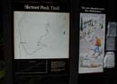
Trailhead |
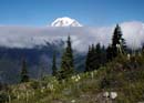
Cloudy Rainier |
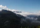
Cloudy To The South |
Beargrass |
Rainier From Summit |
Tatoosh Range |
Me On The Lookout |
Photo Page 2
Home