5-18-03
Earl Peak is one of my favorite
Spring snow scrambles. It can be scrambled from a number of directions.
While I had been up the past 2 Springs it had been 11 years since I climbed
it via Bean Creek on snow. Gary Westerlund and Mark Lawler joined me for
this trip. In the few weeks since our Iron Peak scramble the road had completely
melted out. There is no snow at the Beverly/Bean trailhead. We arrived at
9:30 and were shocked to see more than a dozen cars. This time of year there
should have been 1 or 2. We were loaded down with snowshoes and ice axes
plus lots of clothes. The snow level was forecast to be at 4000' and the
trailhead is at 3600'. The summit of Earl is 7036'.
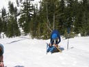
We were on the trail before 10:00. After about 1/2 mile we reached the trail split at Bean Creek. The crossing for the Beverly Creek trail looked about the same as when we crossed a few weeks ago. With poles it's possible to get across with fairly dry feet. With a warm afternoon of snow melt it may be a little tougher. We took the right fork and hiked up the valley along the side of Bean Creek. In a short distance we ran into a sizable amount of snow. In fact, the creek was completely buried for one section. Soon the trail returned to dirt. There were many Glacier Lilies and Spring Beauties along this part of the trail. We soon reached the first problem of the day. There is no snow bridge where the trail crosses the creek. It's too wide to jump. With poles we managed to jump from slick rock to slick rock to small slick log and got across with fairly dry feet. I repositioned a log on the far side which helped with the return crossing. With the Spring snow melt this is not an easy crossing. It is an easy ford if you don't mind dunking your boots. One party came up as we finished crossing and they turned around.
From the crossing the trail remained snow free for a little longer. Soon the snow gets patchy then becomes continuous. The snow is much more consolidated than on our Iron trip. In fact, we never did put on our snowshoes. The unusually cold temperatures this last week probably had a lot to do with it. More on that later. There were plenty of footprints making it easy to follow the route up into the basin. As we rose the trees thinned and we had our first views of Earl Peak. There is still plenty of snow in the basin. We met a group of 3 backpackers heading down after a night in the upper basin. They mentioned a group of several dozen who also were camped in the basin. It turned out to be the Tacoma Mountaineers Scramble Class on an overnight field trip. We saw them heading out from high on Earl. The 3 backpackers were the last people we met all day. There are not any snow bridges near where we wanted to cross the creek. Fortunately it was not difficult to climb down to the creek, cross, and climb back up the other side. The Summer route goes to the right of the peak and climbs in forest to a saddle. From there it's a straight forward ridge walk to the summit. Unfortunately not much sun reached that part of the slope. Farther left, under the summit, it appeared to get more sun. With the cold temperatures the snow was much icier than would be usual this time of year. We were able to scope out a route from the creek and we headed towards an obvious gully to start. As the slope steepened and the snow got icier we pulled out our ice axes. At the base of the gully we turned right and ascended the ridge above the gully. We intersected footprints here. This was a mixed blessing. The previous climber did so with much softer snow. His prints were obvious but so packed and frozen that we could not enlarge them much. To the side was less frozen snow but kicking even marginal steps was tough. Crampons would have been very helpful. We quickly decided that any rock would be better than this icy slope. We slowly chipped steps over to bare rock. This was what saved the trip. The rock was much easier to ascend than the icy slope. We climbed one rock section then pounded steps in the "snow" until we could get back on rock. This was slow but worked well.
As we ascended the wind began to pick up. The temperature was in the mid 30's with blue skies and a cold wind. I had to stop at one point to put on much more clothing and eat. Gary gets most of the credit for kicking steps. He must have sore legs and feet after banging away at the icy slope for several hours. The slope finally began to moderate and the trees became small and bent over by the elements. Gary angled right from the west face to the southwest ridge. The wind was howling now as we slogged the last short distance to the summit. The west face route would have been fairly easy if the snow was softer. The unusually cold spell we had made this much tougher than it should have been. The skies were mostly clear and the views were spectacular. Stuart, Ingalls, Hawkins, Navaho, Three Brothers, Miller, Iron Bear, and many more peaks were visible and still snow covered. There was a localized rain squall to the east over Iron Bear Peak. We proceeded to empty our packs and put on nearly all our clothing. My thermometer read 32 degrees and the wind was a steady 20+ mph. By hunkering down behind some rocks just below the summit we avoided most of the wind. The summit is snow covered but there are many rocks showing on the southwest side. We spent about 45 minutes on the summit.
On the way up I was more concerned about how to get down. The southwest ridge looked OK down to the saddle. From there it would mean going down over 1000' of icy slope. The other option was to try the northeast ridge heading over towards Bean Peak. From the low point on the ridge is a gentler slope down to the upper basin. We saw footprints heading in that direction and decided that was the best route. The footprints were icy but deep enough to give some security. as we descended the snow was definitely softer. It was easier to plunge step in the snow and avoid the icy steps. This route proved to be excellent. We dropped down to the low point well toward Beak Peak. We were amazed to see snowmobile tracks near the top of the ridge on the Hardscrabble Creek side. I have no idea how they were able to get there. The footprints ended where glissade tracks started. After ascending that icy crap on the west face we had given up any hope of getting in a glissade. As it turned out we had a very nice one. The slope was open with nothing to run into. I went first and in a matter of seconds we were 700' down the slope. We soon met the tracks of the army of Mountaineers. It looked like a whole regiment had hiked down. We crossed the creek on a solid snow bridge and descended to where we had crossed in the lower basin to close our loop. The rest of the way was a pleasant walk out. By the time we returned at about 5:00 there was only one other car in the lot.
The snow conditions were less than ideal but this turned out to be a great scramble. The rock portion was a lot of fun. The ridge descent was neat. The views were nothing less than breathtaking. That makes 2 Teanaway scrambles so far this year and many more to come. Totals for the day were about 7 miles and 3500' gained.
Click on thumbnails to get larger pictures.
Photo Page 2
Home
We were on the trail before 10:00. After about 1/2 mile we reached the trail split at Bean Creek. The crossing for the Beverly Creek trail looked about the same as when we crossed a few weeks ago. With poles it's possible to get across with fairly dry feet. With a warm afternoon of snow melt it may be a little tougher. We took the right fork and hiked up the valley along the side of Bean Creek. In a short distance we ran into a sizable amount of snow. In fact, the creek was completely buried for one section. Soon the trail returned to dirt. There were many Glacier Lilies and Spring Beauties along this part of the trail. We soon reached the first problem of the day. There is no snow bridge where the trail crosses the creek. It's too wide to jump. With poles we managed to jump from slick rock to slick rock to small slick log and got across with fairly dry feet. I repositioned a log on the far side which helped with the return crossing. With the Spring snow melt this is not an easy crossing. It is an easy ford if you don't mind dunking your boots. One party came up as we finished crossing and they turned around.
From the crossing the trail remained snow free for a little longer. Soon the snow gets patchy then becomes continuous. The snow is much more consolidated than on our Iron trip. In fact, we never did put on our snowshoes. The unusually cold temperatures this last week probably had a lot to do with it. More on that later. There were plenty of footprints making it easy to follow the route up into the basin. As we rose the trees thinned and we had our first views of Earl Peak. There is still plenty of snow in the basin. We met a group of 3 backpackers heading down after a night in the upper basin. They mentioned a group of several dozen who also were camped in the basin. It turned out to be the Tacoma Mountaineers Scramble Class on an overnight field trip. We saw them heading out from high on Earl. The 3 backpackers were the last people we met all day. There are not any snow bridges near where we wanted to cross the creek. Fortunately it was not difficult to climb down to the creek, cross, and climb back up the other side. The Summer route goes to the right of the peak and climbs in forest to a saddle. From there it's a straight forward ridge walk to the summit. Unfortunately not much sun reached that part of the slope. Farther left, under the summit, it appeared to get more sun. With the cold temperatures the snow was much icier than would be usual this time of year. We were able to scope out a route from the creek and we headed towards an obvious gully to start. As the slope steepened and the snow got icier we pulled out our ice axes. At the base of the gully we turned right and ascended the ridge above the gully. We intersected footprints here. This was a mixed blessing. The previous climber did so with much softer snow. His prints were obvious but so packed and frozen that we could not enlarge them much. To the side was less frozen snow but kicking even marginal steps was tough. Crampons would have been very helpful. We quickly decided that any rock would be better than this icy slope. We slowly chipped steps over to bare rock. This was what saved the trip. The rock was much easier to ascend than the icy slope. We climbed one rock section then pounded steps in the "snow" until we could get back on rock. This was slow but worked well.
As we ascended the wind began to pick up. The temperature was in the mid 30's with blue skies and a cold wind. I had to stop at one point to put on much more clothing and eat. Gary gets most of the credit for kicking steps. He must have sore legs and feet after banging away at the icy slope for several hours. The slope finally began to moderate and the trees became small and bent over by the elements. Gary angled right from the west face to the southwest ridge. The wind was howling now as we slogged the last short distance to the summit. The west face route would have been fairly easy if the snow was softer. The unusually cold spell we had made this much tougher than it should have been. The skies were mostly clear and the views were spectacular. Stuart, Ingalls, Hawkins, Navaho, Three Brothers, Miller, Iron Bear, and many more peaks were visible and still snow covered. There was a localized rain squall to the east over Iron Bear Peak. We proceeded to empty our packs and put on nearly all our clothing. My thermometer read 32 degrees and the wind was a steady 20+ mph. By hunkering down behind some rocks just below the summit we avoided most of the wind. The summit is snow covered but there are many rocks showing on the southwest side. We spent about 45 minutes on the summit.
On the way up I was more concerned about how to get down. The southwest ridge looked OK down to the saddle. From there it would mean going down over 1000' of icy slope. The other option was to try the northeast ridge heading over towards Bean Peak. From the low point on the ridge is a gentler slope down to the upper basin. We saw footprints heading in that direction and decided that was the best route. The footprints were icy but deep enough to give some security. as we descended the snow was definitely softer. It was easier to plunge step in the snow and avoid the icy steps. This route proved to be excellent. We dropped down to the low point well toward Beak Peak. We were amazed to see snowmobile tracks near the top of the ridge on the Hardscrabble Creek side. I have no idea how they were able to get there. The footprints ended where glissade tracks started. After ascending that icy crap on the west face we had given up any hope of getting in a glissade. As it turned out we had a very nice one. The slope was open with nothing to run into. I went first and in a matter of seconds we were 700' down the slope. We soon met the tracks of the army of Mountaineers. It looked like a whole regiment had hiked down. We crossed the creek on a solid snow bridge and descended to where we had crossed in the lower basin to close our loop. The rest of the way was a pleasant walk out. By the time we returned at about 5:00 there was only one other car in the lot.
The snow conditions were less than ideal but this turned out to be a great scramble. The rock portion was a lot of fun. The ridge descent was neat. The views were nothing less than breathtaking. That makes 2 Teanaway scrambles so far this year and many more to come. Totals for the day were about 7 miles and 3500' gained.
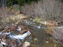
Beverly Trail Ford |
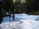
On Bean Creek |
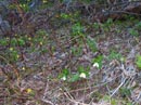
Glacier Lilies & Trillium |
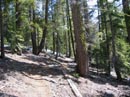
Bare Trail |
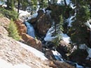
Bean Ceek Cascades |
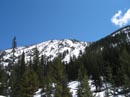
Earl Peak |
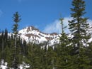
Bean Peak |
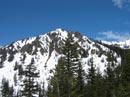
Judy Peak |
Ice Axe Time |
Steep and Icy |
Photo Page 2
Home