9-20-03
I had scrambled
up Vesper Peak one time before. It was in October following the record snow
year of, I believe, 1998. The upper mountain was under 4-6 inches of fresh
snow on top of several feet of ice from the previous winter. I had hoped
to hike up the great rock slabs and instead had a winter like climb. Since
then I had meant to do a late season trip and finally see the mountain without
ice and snow. This was a Mountaineer trip with Karen leading so I was sure
it would be a fun day. We were the first hikers to arrive at the trailhead
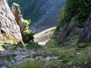
and were on the trail by 9:10. I expected the creek crossings to be very
easy since the summer has been so dry. There was a little rain the last week
and surprisingly the creeks had a substantial flow. They were still easy
enough to rock hop across. The final crossing is the S F Stillaguamish and
that would have been a big problem except for a log across. It is not very
wide but the top has been cut flat. It was not there on my previous trip
and made for a much better crossing than we had then. Soon the forest gives
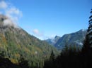
way to more open terrain and some views begin. Sperry Peak is high above
and Mt. Dickerman is across the valley to the north. Fall colors are just
beginning. This will be even more impressive in a few weeks. The group came
back together at the river crossing. We planned to do the same when we reached
the beginning of the upper valley. The trail makes a number of switchbacks
as it climbs up into the valley. This is an old miners trail and is definitely
not up to modern standards. Still it is better than most miners trails I
have been on.
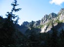
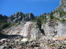
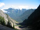
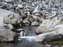
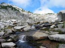
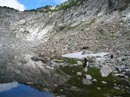
When we entered the upper basin we stopped to wait for the others. From here we could see up towards Morningstar Peak and to the vicinity of Hedlee Pass. The actual pass is not visible until you are directly below it. Karen was with the latter half of the group and they took a side trail which took them across the valley. We soon spotted them and the group came back together. I missed out on their little scrambly adventure. The trail is nearly nonexistent in places as the dirt gives way to talus. There are cairns periodically to keep you on the correct route. Most of the way from here to the lake is on rock. It can be more than a little jarring on the knees, especially on the descent. Higher up the valley the trail is much more obvious and some is even on dirt. When the trail finally switchbacks this is the signal that the climb to Hedlee Pass has begun in earnest. The gully narrows and so do the switchbacks. The grade is not too steep but there are many switchbacks. Hedlee Pass is small and forested. A short trail leads to views out towards Mt. Pugh. On the other side Vesper Peak came into view for the first time. There were a few clouds as we hiked from the start to the pass. I was surprised to see that on the other side of the pass it was mostly cloudy. The clouds were very low. Vesper went from hidden to visible as the clouds blew through. We had agreed to reform the group near the lake so we had the OK to proceed to there. From the pass the grade drops slightly and traverses across a long talus field. Across the rocks is the creek coming from the lake between Vesper and Sperry Peaks. I have heard this lake called "Vesper Lake" and "Elan Lake". Whichever, it is completely surrounded by rocks and still has snow along several sections of the shoreline. An iceberg island is floating in it as well. We dropped our packs where the climbers trail begins to ascend Vesper and hiked the short distance to the lake. A lake this barren seems out of place this low and this far west of the crest.
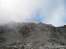
After returning to our packs and having lunch the rest of the party arrived. We bundled up while waiting as it was getting cold. From here to the summit turned out to be some of the most enjoyable scrambling I have done. It was much different, more interesting, and safer than the icy trek I had done before. The route is at first through heather with some trees. It then steepens considerably but is still just a trail. The vegetation soon ends and there was nothing but bare rock between us and the summit. We followed cairns part of the way but they are really not necessary. Most any route will do if you just aim a little to the left of the summit. This rock had as much traction as anything I have ever been on. It might be a little tougher if wet but it was dry today. We purposely tried to find some slightly more challenging spots to make it more interesting. In no time we were on the summit. I expected it to take more than 30 minutes to gain the 1300' from the creek to the summit. Clouds were all around us. They blocked many of the views. On the positive side it was sunny directly above us and we were comfortably warm. The tip of Glacier Peak periodically poked its head above the clouds. Nearby Big Four never did. The clouds were especially bad to the south and west. One other hiker was on top. Her climbing friends had rappelled down to climb the very challenging north face. We later met them and after descending they were unable to cross a huge moat and didn't get to do their climb. Karen wasn't sure she felt well enough to make the summit but make it she did. This is a popular place. The summit register is two years old and it is already full.
Photography from the summit was a little frustrating. Peaks would come out of the clouds for a few seconds then be plunged back out of sight. The clouds did make for some very interesting photos as well. The descent of the rocks was as much fun as the climb. Once I had confidence in the traction I was able to walk down sections which seemed way too steep. After the rocks came the heather slopes and soon we were back at the creek. The rest of the descent was straight forward but slow as a few people were having leg and knee problems. We still made it out comfortably before dark. This turned out to be a fun trip. The slabs of Vesper were even better than I had hoped for. The company was A+ and the weather was not great but it never rained. I'm sure I will be back to Vesper on a more or less regular basis. The distance listed on maps and books seem to conflict for this trip. I estimate that it was about 8 miles round trip with 4200' gained. This also was the trip that put me over 10,000 hiking miles. It has been a lot of fun over 21 years.
Click on thumbnails to get larger pictures.
Photo Page 2
Home
When we entered the upper basin we stopped to wait for the others. From here we could see up towards Morningstar Peak and to the vicinity of Hedlee Pass. The actual pass is not visible until you are directly below it. Karen was with the latter half of the group and they took a side trail which took them across the valley. We soon spotted them and the group came back together. I missed out on their little scrambly adventure. The trail is nearly nonexistent in places as the dirt gives way to talus. There are cairns periodically to keep you on the correct route. Most of the way from here to the lake is on rock. It can be more than a little jarring on the knees, especially on the descent. Higher up the valley the trail is much more obvious and some is even on dirt. When the trail finally switchbacks this is the signal that the climb to Hedlee Pass has begun in earnest. The gully narrows and so do the switchbacks. The grade is not too steep but there are many switchbacks. Hedlee Pass is small and forested. A short trail leads to views out towards Mt. Pugh. On the other side Vesper Peak came into view for the first time. There were a few clouds as we hiked from the start to the pass. I was surprised to see that on the other side of the pass it was mostly cloudy. The clouds were very low. Vesper went from hidden to visible as the clouds blew through. We had agreed to reform the group near the lake so we had the OK to proceed to there. From the pass the grade drops slightly and traverses across a long talus field. Across the rocks is the creek coming from the lake between Vesper and Sperry Peaks. I have heard this lake called "Vesper Lake" and "Elan Lake". Whichever, it is completely surrounded by rocks and still has snow along several sections of the shoreline. An iceberg island is floating in it as well. We dropped our packs where the climbers trail begins to ascend Vesper and hiked the short distance to the lake. A lake this barren seems out of place this low and this far west of the crest.
After returning to our packs and having lunch the rest of the party arrived. We bundled up while waiting as it was getting cold. From here to the summit turned out to be some of the most enjoyable scrambling I have done. It was much different, more interesting, and safer than the icy trek I had done before. The route is at first through heather with some trees. It then steepens considerably but is still just a trail. The vegetation soon ends and there was nothing but bare rock between us and the summit. We followed cairns part of the way but they are really not necessary. Most any route will do if you just aim a little to the left of the summit. This rock had as much traction as anything I have ever been on. It might be a little tougher if wet but it was dry today. We purposely tried to find some slightly more challenging spots to make it more interesting. In no time we were on the summit. I expected it to take more than 30 minutes to gain the 1300' from the creek to the summit. Clouds were all around us. They blocked many of the views. On the positive side it was sunny directly above us and we were comfortably warm. The tip of Glacier Peak periodically poked its head above the clouds. Nearby Big Four never did. The clouds were especially bad to the south and west. One other hiker was on top. Her climbing friends had rappelled down to climb the very challenging north face. We later met them and after descending they were unable to cross a huge moat and didn't get to do their climb. Karen wasn't sure she felt well enough to make the summit but make it she did. This is a popular place. The summit register is two years old and it is already full.
Photography from the summit was a little frustrating. Peaks would come out of the clouds for a few seconds then be plunged back out of sight. The clouds did make for some very interesting photos as well. The descent of the rocks was as much fun as the climb. Once I had confidence in the traction I was able to walk down sections which seemed way too steep. After the rocks came the heather slopes and soon we were back at the creek. The rest of the descent was straight forward but slow as a few people were having leg and knee problems. We still made it out comfortably before dark. This turned out to be a fun trip. The slabs of Vesper were even better than I had hoped for. The company was A+ and the weather was not great but it never rained. I'm sure I will be back to Vesper on a more or less regular basis. The distance listed on maps and books seem to conflict for this trip. I estimate that it was about 8 miles round trip with 4200' gained. This also was the trip that put me over 10,000 hiking miles. It has been a lot of fun over 21 years.
Mt. Dickerman |
Upper Basin |
Basin Waterfall |
View Of Basin |
Hedlee Gully |
Vesper Creek |
Creek Again |

Lake Reflection |
Vesper Summit |
Lake |
Photo Page 2
Home