1-11-03
I first hiked this trail on a sunny
early September day in 1990. I had not been back since. This time I did it
with a group of Mountaineers as a snowshoe trip. It was about 40 degrees cooler
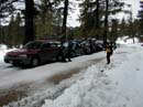
and a fine winter trip. The route starts at the end of plowing on the Middle
Fork Teanaway River Road. Plowing ends at the end of pavement. There is a
turnaround with "no parking" signs posted. Snow was right up to the edge
of the road. We went a little farther and parked in the small area between
a driveway and a snow berm which marked the end of driving. We squeezed in
our 5 vehicles. By about 9:15 we were on our way. The road was nicely packed
down by snowmobiles and with a temperature of about 30 degrees we did not
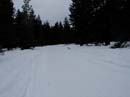
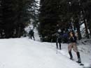
need to put on our snowshoes immediately. The road begins fairly level, passing
a campgrounds in about one mile. Another mile took us across the Middle Fork
and to the turn off for the Yellow Hill trail.
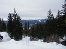
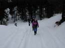
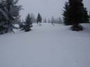
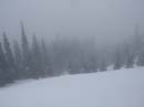
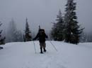
Snowmobiles had recently been up this road as well. We continued on without snowshoes. Within about 1 1/2 miles more the road ended and it was time to put on snowshoes. The rest of the route follows a ridge with several high points and hence a few ups and downs. The going started to get steeper at this point. Snowmobile tracks started up the ridge but they gave up fairly soon. From that point on there was untouched snow with not a track to be seen. The cloud cover was just above us and ruined any chance of seeing the many peaks around us. The ridge is mostly forested with a few views out. The snow was crusty in the trees but not too bad in the open. This turned out to be a longer than advertised trip but the group stayed together well. The last push to the top turned much steeper. I was OK with my MSR snowshoes. The crampon like teeth were much appreciated. The real summit was a short distance beyond the first top but only about 10' higher. It took us about 4 hours going up, reaching the summit at about 1:20. The temperature was in the high 20's but there was no wind. By 2:00 it was time to head down.
The trip down was much faster. The snow, torn up by the 11 members of our group was a little hard on my ankles but didn't slow us down. The clouds never did break. On the summit we were in them. As we descended, we could see the snow covered valleys below but not the peaks. We stayed on the ridge longer coming down and intersected the road at a lower level. At that point I took my snowshoes off. It was a bit slick on the road with boots but easier than wearing the snowshoes. Another bonus was the quiet. MSR snowshoes are very noisy on hard snow and ice and we had 9 pairs in the group. It was 4:00 when we reached the Middle Fork road. It was starting to get dark but it's easy to walk out on a wide snow covered road. In fact, the first 2 miles would have been much easier to ski each way rather than walk. I'll try that next time. Less than a mile from the car we were passed by the only snowmobiles we saw all day. We reached the cars just before 5:00 as darkness set in.
This is a nice hike in the Summer with motorcylcs being the only downside. It is a much better Winter snowshoe trip. We didn't have any good views but the snow conditions were good for this El Nino year. The totals were 12 miles with about 3300' gained. I will be back to do this one in the future and I will bring skis and snowshoes.