6-05-04
After another sunny week the weekend
forecast was for another rainy weekend. Once again I headed east. It rained
from Issaquah all the way across Snoqualmie Pass to Hyak. The east side
was cloudy but not wet. I have done Esmerelda several times as a boulder
and scree scramble but not on snow. I was looking forward to a new experience.
I hoped there would be enough snow to cover lots of the loose scree. I
was out of the house at 6:15 and on the DeRoux Trail by 8:25. The trailhead
is at about 3760' and the summit is at 6765'. The Teanaway River crossing
comes up fast. Just across it was a grassy meadow covered in shooting stars.
There were more flowers than I expected. The lower section was lined by
trillium. Most were still at their peak. The trail is in great shape. Only
some chewed up sections caused by horses mar the tread. There was some snow
in the valley bottom in the first mile and I hoped that continuous snow
would not begin until much higher. That proved to be the case.
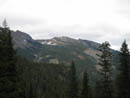
The trail mostly stays within sight or sound of DeRoux Creek. The creek itself loses 800' in 2/3 of a mile. There are continuous waterfalls and lots of noise. The creek path is mostly in a narrow gorge. Soon after the intersection with the DeRoux Spur Trail I came upon a horseshoe on the trail. Perhaps a good luck omen? It was gone when I returned. The route is mostly in forest but there are a few openings. At the first one I had a nice view of Iron and Teanaway Peaks across the valley. The snow on their west sides is melting out fast. A little later I had a good look at Koppen Mountain. The "sheep driveway" to it's summit is highlighted with snow. It will be a few more weeks before that has melted out. At one point I lost the trail at the first big snow patch. Heading up the snow I found it again as it went back onto dirt higher up.
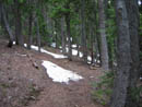
At about 4800' the trail became mostly snow covered. The terrain was fairly flat through here. I just continued straight and once again crossed right over the trail on a dirt stretch. It soon headed back towards the creek and was mostly bare again. The trail rounded a bend and entered the upper basin. Glacier lilies carpeted the hillside all along there. I kicked steps across a few short snow patches right above the creek and reached the crossing point. Now, where was that crossing log? The bad news is the log I used just a few years back is gone. The water is about as high as it gets. The creek is narrow, fast, and deep in spots and wider and shallower in others. The hillside is steep and snow covered making it difficult to go farther upstream. I went a little farther but there were no logs across. Returning to near the trail crossing spot I figured I would have to ford. I had one last hope of keeping dry boots. There is one spot with a submerged log, a wet skinny log and some piled up branches anchored in the middle. Using poles for balance I tightroped the skinny wet log, jumped to the branches, and jumped again to a wet log near the other side. It worked but it wasn't easy. Getting across is not too hard. Keeping your boots dry is a challenge.
The trail winds farther north and again moves out of the snow. Sun reaches here and nearly all the snow is gone. The creek crossing is at about 5000'. The next part is among my favorite sections of this trail. The route winds through bright green meadows never far from the creek. Glacier lilies abound. There were several other varieties of flowers I can't name. The trail soon begins two sets of long switchbacks. Each leg crosses half a dozen creeks. Most of these were lined with more shooting stars. This was one of the best shooting star displays I have seen. Up to this point there were several logs down but none of them required leaving the trail. A few could be stepped over and a few ducked under. They will stop horses until removed but pose no problem for hikers.
After the final switchback the trail heads towards Gallagher Head Lake. Deroux Peak was visible on the south ridge of the valley. I turned off to begin the scramble where the trail reached a boulder field above the trail. Low clouds were blowing in. I watched as an initial view of Hawkins Mountain was quickly obscured in billowy white clouds. A fast short scramble up boulders led to the lip of a large basin. I should have been able to see the summit but it was lost in the clouds. This made the route finding a bit tougher. I could see that there was plenty of snow higher on the mountain. I crossed some snow and climbed another steep boulder field. I crossed another snow field and climbed yet another boulder field. At the top of this was solid snow. A ridge climbed to my right but it was covered in small trees. In front of me was a snowy gully. I headed up the gully. At this point I took out my ice axe. The snow was firm but soft enough to give good traction. The gulley steepened and the snow got harder but was still fine for kicking steps. The forecast was for wind gusts up to 40 mph but so far they were not bad.
I still could not see the summit and the terrain seemed much different than I remembered when under a blanket of snow. The grade remained comfortable and the gully seemed to be going about where I imagined I needed to be. I cut to the right through small trees and reached the bottom of an open snow slope. I imagined I could see the ridge top through the blowing clouds. Half way up this I could discern the pass between the two western summits right above me. Once at the pass I was able to get onto dirt and traverse to directly under the summit and then scramble straight up. I didn't want to mess with the big cornice on the ridge top. I arrived at the summit at 11:25, exactly 3 hours after my start. Esmerelda has great views of Stuart, Hawkins, and myriad other peaks. This day my visiblility was about 75 feet. The summit register was put up in August 2003 and had only a dozen visits. I was the first to sign in this year. I couldn't even see the other summit only a few hundred feet away. On the positive side it had not rained and the wind was brisk but not even half of the forecast. It was a balmy 42 degrees. I put on all my clothes and spent about half an hour on top.
The first part of the trip down was fast. A combination of plunge stepping and glissades had me down off the snow in no time. The boulders and scree went slower. When I reached the trail again I considered continuing on to Gallagher Head Lake but decided to take a slow trip down instead, enjoying the multitudes of flowers. I enjoyed it so much I managed to take over 100 photos in a six hour hike. I made it back across the creek the same way again. After crossing DeRoux Creek I had a few minutes of drizzle but that was the extent of rain for the day. While descending I had seen some other footprint in the snow but they were heading down. Someone had come up after me but had already turned around. At the trailhead there was one other vehicle. For the day I covered about 8 1/2 miles with 3000' of elevation gain. I saw exactly zero people. I had no views but it turned out to be a really fun scramble.
Click on thumbnails to get larger pictures.
Photo Page 2
Trips - 2004
Home
The trail mostly stays within sight or sound of DeRoux Creek. The creek itself loses 800' in 2/3 of a mile. There are continuous waterfalls and lots of noise. The creek path is mostly in a narrow gorge. Soon after the intersection with the DeRoux Spur Trail I came upon a horseshoe on the trail. Perhaps a good luck omen? It was gone when I returned. The route is mostly in forest but there are a few openings. At the first one I had a nice view of Iron and Teanaway Peaks across the valley. The snow on their west sides is melting out fast. A little later I had a good look at Koppen Mountain. The "sheep driveway" to it's summit is highlighted with snow. It will be a few more weeks before that has melted out. At one point I lost the trail at the first big snow patch. Heading up the snow I found it again as it went back onto dirt higher up.
At about 4800' the trail became mostly snow covered. The terrain was fairly flat through here. I just continued straight and once again crossed right over the trail on a dirt stretch. It soon headed back towards the creek and was mostly bare again. The trail rounded a bend and entered the upper basin. Glacier lilies carpeted the hillside all along there. I kicked steps across a few short snow patches right above the creek and reached the crossing point. Now, where was that crossing log? The bad news is the log I used just a few years back is gone. The water is about as high as it gets. The creek is narrow, fast, and deep in spots and wider and shallower in others. The hillside is steep and snow covered making it difficult to go farther upstream. I went a little farther but there were no logs across. Returning to near the trail crossing spot I figured I would have to ford. I had one last hope of keeping dry boots. There is one spot with a submerged log, a wet skinny log and some piled up branches anchored in the middle. Using poles for balance I tightroped the skinny wet log, jumped to the branches, and jumped again to a wet log near the other side. It worked but it wasn't easy. Getting across is not too hard. Keeping your boots dry is a challenge.
The trail winds farther north and again moves out of the snow. Sun reaches here and nearly all the snow is gone. The creek crossing is at about 5000'. The next part is among my favorite sections of this trail. The route winds through bright green meadows never far from the creek. Glacier lilies abound. There were several other varieties of flowers I can't name. The trail soon begins two sets of long switchbacks. Each leg crosses half a dozen creeks. Most of these were lined with more shooting stars. This was one of the best shooting star displays I have seen. Up to this point there were several logs down but none of them required leaving the trail. A few could be stepped over and a few ducked under. They will stop horses until removed but pose no problem for hikers.
After the final switchback the trail heads towards Gallagher Head Lake. Deroux Peak was visible on the south ridge of the valley. I turned off to begin the scramble where the trail reached a boulder field above the trail. Low clouds were blowing in. I watched as an initial view of Hawkins Mountain was quickly obscured in billowy white clouds. A fast short scramble up boulders led to the lip of a large basin. I should have been able to see the summit but it was lost in the clouds. This made the route finding a bit tougher. I could see that there was plenty of snow higher on the mountain. I crossed some snow and climbed another steep boulder field. I crossed another snow field and climbed yet another boulder field. At the top of this was solid snow. A ridge climbed to my right but it was covered in small trees. In front of me was a snowy gully. I headed up the gully. At this point I took out my ice axe. The snow was firm but soft enough to give good traction. The gulley steepened and the snow got harder but was still fine for kicking steps. The forecast was for wind gusts up to 40 mph but so far they were not bad.
I still could not see the summit and the terrain seemed much different than I remembered when under a blanket of snow. The grade remained comfortable and the gully seemed to be going about where I imagined I needed to be. I cut to the right through small trees and reached the bottom of an open snow slope. I imagined I could see the ridge top through the blowing clouds. Half way up this I could discern the pass between the two western summits right above me. Once at the pass I was able to get onto dirt and traverse to directly under the summit and then scramble straight up. I didn't want to mess with the big cornice on the ridge top. I arrived at the summit at 11:25, exactly 3 hours after my start. Esmerelda has great views of Stuart, Hawkins, and myriad other peaks. This day my visiblility was about 75 feet. The summit register was put up in August 2003 and had only a dozen visits. I was the first to sign in this year. I couldn't even see the other summit only a few hundred feet away. On the positive side it had not rained and the wind was brisk but not even half of the forecast. It was a balmy 42 degrees. I put on all my clothes and spent about half an hour on top.
The first part of the trip down was fast. A combination of plunge stepping and glissades had me down off the snow in no time. The boulders and scree went slower. When I reached the trail again I considered continuing on to Gallagher Head Lake but decided to take a slow trip down instead, enjoying the multitudes of flowers. I enjoyed it so much I managed to take over 100 photos in a six hour hike. I made it back across the creek the same way again. After crossing DeRoux Creek I had a few minutes of drizzle but that was the extent of rain for the day. While descending I had seen some other footprint in the snow but they were heading down. Someone had come up after me but had already turned around. At the trailhead there was one other vehicle. For the day I covered about 8 1/2 miles with 3000' of elevation gain. I saw exactly zero people. I had no views but it turned out to be a really fun scramble.
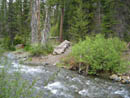
Old Bridge |
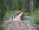
New Bridge |
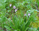
Shooting Stars |
East Esmerelda Peak |
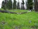
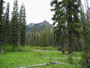
Grassy Slope |
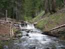
DeRoux Creek |
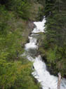
Falls |
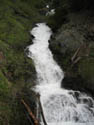
Another Falls |
Iron & Teanaway |
First Snow |
Photo Page 2
Trips - 2004
Home