8-07-04
This was a hike I had long planned.
Well, since along about 7:00 pm the evening before. I figured I was through
with the Teanaway until October larch time but the weather intervened. The
west slopes were forecast to be raining in the morning and so I turned my
attention to the east once again. The Teanaway is usually about 80 to 90
degrees this time of year but the high was expected to be only about 70. Best
of all there was no chance of rain. I love to scramble the great rock on
Bean Peak and do a loop trip over the peak most years. This time, to make
it more interesting, I decided to add Iron Peak to the loop. I hit Iron most
springs, including this year
, but had not been up without snow in quite a few years. It was only a
little overcast in Seattle but between the floating bridge beyond Hyak my
wipers stayed on. I was more than happy to continue east. By the time I reached
Cle Elum it was all blue sky. I reached the Beverly Creek trailhead at 8:30
and I was on the trail within 10 minutes.
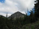
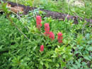
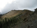
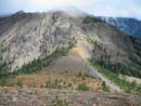
The bushes were all wet confirming my plan to hike clockwise and leave the overgrown lower Bean Creek trail until the afternoon. Bean Creek had more water than I expected in August but it was no problem getting across. The morning was cool and very comfortable for hiking. I made good time, reaching the Fourth Creek intersection in 66 minutes. The next short section to Beverly Creek was filled with wildflowers. Paintbrush was the main flower. I expected they would all be long gone with this dry hot summer. This boded well for my later walk through Bean Creek Basin. The actual trail goes to the low pass below Teanaway Peak. This is substantially longer than my usual direct ascent to the summit on snow. At the Iron Peak trail junction I turned left and headed uphill. All the small creeks along the route were still running although the last snow melted out at least 6 weeks ago. I soon reached the ridge top and turned left again, aiming for the summit. As I proceeded up the ridge I saw clouds streaming up the valley. They were above and well below me. The top half of Mt. Stuart was in the clouds. That situation did not change all day long.
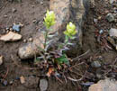
The old ridge "route" has now become a regular trail. The switchbacks up the first steep slope look like regular tread. This is not a bad thing as it keeps people on the route and off of the fragile flowers. I saw several light yellow/green paintbrush flowers along the ridge. That is one variety that I seldom see. I arrived at the 6520' summit just about the same time as the clouds. I could still see down into Beverly Basin but otherwise my visibility was almost nil. It was actually nice when contrasted to all the hot hikes I have had this summer. I would guess it was about 45 degrees on top but there was almost no wind. I had half my lunch here at 11:00 and saved the rest for Bean Peak. After a half hour stay I was off again at 11:10.
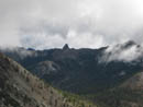
Just after turning onto the Beverly Creek trail I met my first hikers of the day. This group included an old friend. Linda was with her usual group heading up Iron. I wasn't the only one to head east to avoid the rain. Back at the Fourth Creek junction I met the backpacker who was leaving the trailhead just after me. Two women on horses came by and headed up the Fourth Creek Trail. I gave them a little head start and then followed. I expected the horses to quickly pull away on this uphill grade. Instead I started to catch up. Shortly before Fourth Creek Pass they stopped and I went on by. This was the first and likely the only time I will ever pass a group of horses. I hit the pass and kept on going. The trail splits but the sign is now gone. The left hand trail drops down to Ingalls Creek. The right hand trail is the County Line Trail and crosses a long meadow before climbing to the ridge top just right of Volcanic Neck. None of the creeks along the trail were dry. By August only two are usually still running. Either it rained hard here the last few days or this area was not been as dry as much of the mountains. With those horses behind me I did not take any breaks. I soon reached the base of the ridge.
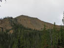
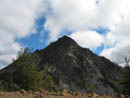
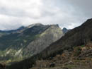
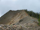
The trail has at times been a little sketchy up to the ridge top. This year it is in fine shape. I crested the ridge just as the horses reached the bottom. From the ridge I could see Navaho Peak . I've already been up it twice this year. I had a great viewpoint of the Stuart Range. Well, actually I had a great view of the bottom half of the Stuart Range. The tops were lost in the clouds. The next section is among my favorite. You can follow right on the ridge top all the way to the summit of Bean. Mostly it is easy walking or scrambling. I topped out on Bean Peak at 1:35. The sun was now moving in and out of the clouds. It was occasionally providing some warming. Once again there was almost no wind. I heard voices... I mean I REALLY DID hear voices. I never did see the people. I have noticed that voices can carry a long distance around there. This is a real favorite among summits for me. I spent some time scrambling up and down the peak. It has some of the best rock I have been on. It is very sticky with lots of hand and foot holds on very steep rock. I was happy to spend 1 1/4 hours on top.
I usually either head down the ridge connecting to Earl Peak or head down the face and contour left to reach the final grass and scree slope into the basin. This time I decided to explore to the right. I dropped down the face and headed right on talus and boulders. This turned out to be a very nice route. I managed to avoid the scree to the east. After dropping 1100' I reached the top of Bean Creek Basin. Paintbrush were still flowering in profusion. The lupine is all finished though. I crossed over to the left side and descended to where I knew I could pick up the trail. Unlike nearly every other time I have dropped into the basin there were no people. I guess the bad weather scared most people away. I was in no hurry and slowly worked my way down the valley. I had many opportunities to take flower photos. In the lower basin the flowers petered out and I began to quicken my pace. After dropping down into the forest I passed the fourth and last party of the day. The rest of the descent was uneventful. At 4:45 I reached my car ending a great 8 hour day. I had 2 summits, many more flowers than expected, very few people, and nice cool summer temperatures. It was an excellent last minute planned hike.
Click on thumbnails to get larger pictures.
Photo Page 2
Trips - 2004
Home
The bushes were all wet confirming my plan to hike clockwise and leave the overgrown lower Bean Creek trail until the afternoon. Bean Creek had more water than I expected in August but it was no problem getting across. The morning was cool and very comfortable for hiking. I made good time, reaching the Fourth Creek intersection in 66 minutes. The next short section to Beverly Creek was filled with wildflowers. Paintbrush was the main flower. I expected they would all be long gone with this dry hot summer. This boded well for my later walk through Bean Creek Basin. The actual trail goes to the low pass below Teanaway Peak. This is substantially longer than my usual direct ascent to the summit on snow. At the Iron Peak trail junction I turned left and headed uphill. All the small creeks along the route were still running although the last snow melted out at least 6 weeks ago. I soon reached the ridge top and turned left again, aiming for the summit. As I proceeded up the ridge I saw clouds streaming up the valley. They were above and well below me. The top half of Mt. Stuart was in the clouds. That situation did not change all day long.
The old ridge "route" has now become a regular trail. The switchbacks up the first steep slope look like regular tread. This is not a bad thing as it keeps people on the route and off of the fragile flowers. I saw several light yellow/green paintbrush flowers along the ridge. That is one variety that I seldom see. I arrived at the 6520' summit just about the same time as the clouds. I could still see down into Beverly Basin but otherwise my visibility was almost nil. It was actually nice when contrasted to all the hot hikes I have had this summer. I would guess it was about 45 degrees on top but there was almost no wind. I had half my lunch here at 11:00 and saved the rest for Bean Peak. After a half hour stay I was off again at 11:10.
Just after turning onto the Beverly Creek trail I met my first hikers of the day. This group included an old friend. Linda was with her usual group heading up Iron. I wasn't the only one to head east to avoid the rain. Back at the Fourth Creek junction I met the backpacker who was leaving the trailhead just after me. Two women on horses came by and headed up the Fourth Creek Trail. I gave them a little head start and then followed. I expected the horses to quickly pull away on this uphill grade. Instead I started to catch up. Shortly before Fourth Creek Pass they stopped and I went on by. This was the first and likely the only time I will ever pass a group of horses. I hit the pass and kept on going. The trail splits but the sign is now gone. The left hand trail drops down to Ingalls Creek. The right hand trail is the County Line Trail and crosses a long meadow before climbing to the ridge top just right of Volcanic Neck. None of the creeks along the trail were dry. By August only two are usually still running. Either it rained hard here the last few days or this area was not been as dry as much of the mountains. With those horses behind me I did not take any breaks. I soon reached the base of the ridge.
The trail has at times been a little sketchy up to the ridge top. This year it is in fine shape. I crested the ridge just as the horses reached the bottom. From the ridge I could see Navaho Peak . I've already been up it twice this year. I had a great viewpoint of the Stuart Range. Well, actually I had a great view of the bottom half of the Stuart Range. The tops were lost in the clouds. The next section is among my favorite. You can follow right on the ridge top all the way to the summit of Bean. Mostly it is easy walking or scrambling. I topped out on Bean Peak at 1:35. The sun was now moving in and out of the clouds. It was occasionally providing some warming. Once again there was almost no wind. I heard voices... I mean I REALLY DID hear voices. I never did see the people. I have noticed that voices can carry a long distance around there. This is a real favorite among summits for me. I spent some time scrambling up and down the peak. It has some of the best rock I have been on. It is very sticky with lots of hand and foot holds on very steep rock. I was happy to spend 1 1/4 hours on top.
I usually either head down the ridge connecting to Earl Peak or head down the face and contour left to reach the final grass and scree slope into the basin. This time I decided to explore to the right. I dropped down the face and headed right on talus and boulders. This turned out to be a very nice route. I managed to avoid the scree to the east. After dropping 1100' I reached the top of Bean Creek Basin. Paintbrush were still flowering in profusion. The lupine is all finished though. I crossed over to the left side and descended to where I knew I could pick up the trail. Unlike nearly every other time I have dropped into the basin there were no people. I guess the bad weather scared most people away. I was in no hurry and slowly worked my way down the valley. I had many opportunities to take flower photos. In the lower basin the flowers petered out and I began to quicken my pace. After dropping down into the forest I passed the fourth and last party of the day. The rest of the descent was uneventful. At 4:45 I reached my car ending a great 8 hour day. I had 2 summits, many more flowers than expected, very few people, and nice cool summer temperatures. It was an excellent last minute planned hike.
Bill Peak |
Iron Peak |
Indean Paintbrush |
Bill Peak |
Iron Summit Ridge |
Unusual Paintbrush |
Volcanic Neck |
Esmerelda Peaks |
Iron Ridge |
Ridge Walk |
Photo Page 2
Trips - 2004
Home