12-04-04
Early December is usually a little late to be scrambling
in the Teanaway. This year the snow has been light and the road to the
Miller Peak trailhead was still open. This was a Mountaineer scramble.
There were several people ahead of me on the wait list when I signed up
but the forecast for bad weather seemed to have scared many of them away.
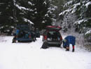
We had only 7 people for the trip. Even meeting in Issaquah at 6:15 it
was still nearly 8:45 before we began hiking. There was a little patchy
snow from 29 Pines to the Stafford turn off. The Stafford Road was completely
covered with a thin layer of packed snow. The usual routes for scrambling
Little Navaho start on the Stafford Creek Trail. The ridge can be scrambled
from either the right or the left side of the peak. Richard and Lynn, our
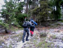
leaders had another route in mind. From the 3200' Miller trailhead we headed
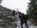
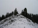
cross country straight up the slope. It was snowing when we began. The underbrush
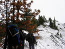
was not too bad. As we climbed onto the defined ridge it was even better.
The slope was moderately steep but not difficult.
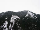
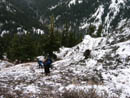
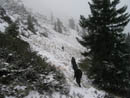
The first 1200' went smoothly. As we climbed above the forest the slope was covered with a thin coating of snow. Not enough to provide good traction. Just enough to make the going slick. At 4400' we had to leave the ridge and contour to the right. The slick snow made what should have been easy into a much harder traverse. We climbed over a small rib, descended a little, then climbed back up to the ridge. The group began another traverse on the right while I followed the ridge top just above them. This proved to be easier than more side hilling on slick rocks and scree. When the traverse worsened the group climbed back up to the ridge top. I continued ahead as the going remained fairly good.
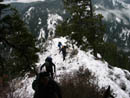
I was able to remain mostly on the narrow crest of the snowy ridge top. After the group reformed I continued to lead until the ridge dropped slightly to a flat area at a gap. We were able to take a break under some trees out of the weather. This was at about 4900'. Just above here another ridge came in from the southwest. The two ridges met at Point 5018. The route dropped down and climbed again still along the ridge top. We shortly reached another roadblock and began another traverse along the right side of the ridge. This one was longer than the first but with better footing. Still it was snow covered rock and scree. We were able to again climb back up to the ridge top. The tough footing and route finding decisions made for slow travel. With the short days it was becoming less and less likely that we would make it up Little Navaho. If we could, then a descent to the Stafford Creek Trail would speed up our return considerably.
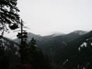
We soon had to leave the ridge again, this time to the left side. The slope was quite steep and a slip could send one a long way down. We knew there was at least one more difficulty near point 5818. Soon after that the ridge where the County Line Trail once ran would be reached. Near that point our traverse became untenable. We once again climbed back up to the crest. The ridge did not go. The only option was to drop down a narrow slot to the slopes on the right side. It was snow covered with questionable footing. It was now around 12:00 and prudence required we turn around. We were just over a mile and 800' from the summit of Little Navaho.
The return trip was faster but still relatively slow. We saw fresh deer tracks along the ridge on the way up and more fresh ones coming back down. The snowfall never amounted to much as flurries came and went. As always, going down thin slick snow covered rock was even tougher than going up. My ankles will probably be sore for days thanks to constantly edging my boots. We avoided any other difficulties as we stayed on our route up most of the way. Lower down there was little snow so no footprints to follow. We eventually came out on the road just before the parking lot.
The sensible route would have been to go up the Stafford Creek Trail. Sensible but kind of dull. We did not make the summit but this proved to be a much more interesting route. The question now is what the route would be like with bare rock. Perhaps I'll have to come back next year to find out.
Click on thumbnails to get larger pictures.
Photo Page 2
Trips - 2004
Home
The first 1200' went smoothly. As we climbed above the forest the slope was covered with a thin coating of snow. Not enough to provide good traction. Just enough to make the going slick. At 4400' we had to leave the ridge and contour to the right. The slick snow made what should have been easy into a much harder traverse. We climbed over a small rib, descended a little, then climbed back up to the ridge. The group began another traverse on the right while I followed the ridge top just above them. This proved to be easier than more side hilling on slick rocks and scree. When the traverse worsened the group climbed back up to the ridge top. I continued ahead as the going remained fairly good.
I was able to remain mostly on the narrow crest of the snowy ridge top. After the group reformed I continued to lead until the ridge dropped slightly to a flat area at a gap. We were able to take a break under some trees out of the weather. This was at about 4900'. Just above here another ridge came in from the southwest. The two ridges met at Point 5018. The route dropped down and climbed again still along the ridge top. We shortly reached another roadblock and began another traverse along the right side of the ridge. This one was longer than the first but with better footing. Still it was snow covered rock and scree. We were able to again climb back up to the ridge top. The tough footing and route finding decisions made for slow travel. With the short days it was becoming less and less likely that we would make it up Little Navaho. If we could, then a descent to the Stafford Creek Trail would speed up our return considerably.
We soon had to leave the ridge again, this time to the left side. The slope was quite steep and a slip could send one a long way down. We knew there was at least one more difficulty near point 5818. Soon after that the ridge where the County Line Trail once ran would be reached. Near that point our traverse became untenable. We once again climbed back up to the crest. The ridge did not go. The only option was to drop down a narrow slot to the slopes on the right side. It was snow covered with questionable footing. It was now around 12:00 and prudence required we turn around. We were just over a mile and 800' from the summit of Little Navaho.
The return trip was faster but still relatively slow. We saw fresh deer tracks along the ridge on the way up and more fresh ones coming back down. The snowfall never amounted to much as flurries came and went. As always, going down thin slick snow covered rock was even tougher than going up. My ankles will probably be sore for days thanks to constantly edging my boots. We avoided any other difficulties as we stayed on our route up most of the way. Lower down there was little snow so no footprints to follow. We eventually came out on the road just before the parking lot.
The sensible route would have been to go up the Stafford Creek Trail. Sensible but kind of dull. We did not make the summit but this proved to be a much more interesting route. The question now is what the route would be like with bare rock. Perhaps I'll have to come back next year to find out.
Trailhead |
Lower Route |
Across The Valley |
Bear Creek Valley |
On The Rocks |
First Traverse |
Ridge Top |
Ridge Trees |
Flat Spot |
Second Traverse |
Photo Page 2
Trips - 2004
Home