1-11-04
Last winter I hiked up South Bessemer
Mt. but had no views. When I saw that a Mountaineer trip was heading there
I signed up. It didn't hurt that Richard Burt and Lynn Graf were leading.
The snowshoe scrambles they led last year to Yellow Hill, Thomas Mt., and
Arrowhead Mt. were among the best I did. We met at the North Bend RS at
7:00. The sun was nowhere to be seen yet. It turned out that very recent
info contradicted news that the Middle Fork Road was drivable to the Bessemer
trailhead. We kicked around some other ideas and Revolution Peak won out.
I have hiked to Granite Lakes and read reports at WTA on Revolution but I
had never done it. We drove on to the Mailbox Peak trailhead as the sun was
nearly above the horizon. The start has changed since my last trip to Granite
Lakes and we headed up the wrong road. It didn't take long to realize our
mistake and we returned to the Middle Fork Road and turned right. The gate
is now a few hundred yards away. The road was slushy and a thin coating of
snow covered the Granite Lakes Road. Cross country ski tracks were present
from a recent trip. I managed to slog along for about a mile before the snowshoes
went on. At the first obvious switchback we chose to go straight. The road
is very overgrown and we soon found out why. The entire road washed steeply
down the hillside. There was very little room to get around the washout.
I would not recommend anyone try this as the switchbacking new road goes
up and around this problem. After this adventure we met back up with the
road. The skiers had given up and only animal tracks were seen for the rest
of the way up.
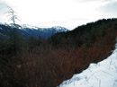
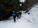
The road is very gentle and it takes a long time to gain much elevation. At about 2.6 miles we rounded the north ridge of Mailbox and went from northeast to southeast. We entered the valley of Granite Creek and quickly picked up the creek. At 3 miles we crossed the creek. So far we had gained only 1100'. The road began to steepen as we moved up the valley. Just short of 5 miles we passed the spur over to Granite Lakes. At 3125' we were still 2000' below the summit. The day had been a little overcast but no signs of rain were around. The last 2 miles gain 2000' as we stayed mostly on the road until we were under the false summit and the forested slopes became wide open. The snow was fairly firm but the leader did sink a little with each step. We traded off the lead and kept as fresh as possible. We found 5 trees down just after the Granite Creek crossing. Two we went over and three we went under. None were too difficult. That was the extent of blowdowns. High on the mountain a few places on the road had short snow free spots which required climbing down and climbing back up the other side. These were an annoyance but we all managed to get by.
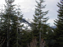
At about 4500' we left the road and headed straight up. This cut off some long switchbacks. The going was steep in places but the snow had good grip. If anything it was a little soft. My hip was hurting here but we were so close I kept on going. The cabin I had heard about came into view a few hundred feet below it. It is about as unexpected sight way up here as one could imagine. As we crested the ridge the views became even better. We could see buildings in downtown Seattle, Mt. Si, Mt. Teneriffe, and other Middle Fork peaks. The base of Rainier was visible. McClellan Butte showed from a direction I'd never seen before. Even Pratt Mt. and Granite Mt. were seen. The Granite Lakes were in the shade below us. The last 100' was a short slog and I was about out of gas. We had a strong group as everyone made the summit.
Revolution Peak was "just down the ridge" from us but there was no chance of making it this day. It's about 7 miles to the top and we did nearly all of it on snowshoes. It was 1:00 pm when we summited. It took exactly 5 hours to make it. With only 4 hours of daylight left we weren't sure if we would make it out in daylight. We spent only 15 minutes on top eating lunch and enjoying this unique view. The clouds had broken on the final climb and it was sunny and beautiful on top. Thompson Lake was now visible below and peaks to the northeast. I felt a bad leg cramp at lunch and was not happy with a steep descent coming up. The first steep drop off the false summit was fast but I cramped up badly. Hmm. only 6 3/4 miles to go and I could barely move. In 20+ years of hiking I have never had that happen before. I had one cramp induced fall on the way down but we made it quickly back to the road. I felt better on the road until we came to the bare spots. Dropping down and climbing back up the other side caused me to seriously cramp up again. Getting through those spots was agony. Once back on smooth road I was fine and had no more problems coming down.
The last 6 miles was just one long snowshoe slog. We made good time in our packed down trench. The temperature remained at a balmy 40 degrees as we kept on descending. The road is gentle enough that I wished I had cross country skies instead of snowshoes. At long last we reached the point where we had taken the old washed out road. This time we opted for the new road. It is longer but much easier. The gate finally came into sight and we reached the Middle Fork Road at 4:15. It was well before dark as we came all the way down in 3 hours. I had hoped to do South Bessemer with a view but instead had a chance to reach a first time summit. The summit view was great, the company was great, and the day was a resounding if painful success. Totals on the day were about 14 miles with 4400' gained.
Click on thumbnails to get larger pictures.
Photo Page 2
The road is very gentle and it takes a long time to gain much elevation. At about 2.6 miles we rounded the north ridge of Mailbox and went from northeast to southeast. We entered the valley of Granite Creek and quickly picked up the creek. At 3 miles we crossed the creek. So far we had gained only 1100'. The road began to steepen as we moved up the valley. Just short of 5 miles we passed the spur over to Granite Lakes. At 3125' we were still 2000' below the summit. The day had been a little overcast but no signs of rain were around. The last 2 miles gain 2000' as we stayed mostly on the road until we were under the false summit and the forested slopes became wide open. The snow was fairly firm but the leader did sink a little with each step. We traded off the lead and kept as fresh as possible. We found 5 trees down just after the Granite Creek crossing. Two we went over and three we went under. None were too difficult. That was the extent of blowdowns. High on the mountain a few places on the road had short snow free spots which required climbing down and climbing back up the other side. These were an annoyance but we all managed to get by.
At about 4500' we left the road and headed straight up. This cut off some long switchbacks. The going was steep in places but the snow had good grip. If anything it was a little soft. My hip was hurting here but we were so close I kept on going. The cabin I had heard about came into view a few hundred feet below it. It is about as unexpected sight way up here as one could imagine. As we crested the ridge the views became even better. We could see buildings in downtown Seattle, Mt. Si, Mt. Teneriffe, and other Middle Fork peaks. The base of Rainier was visible. McClellan Butte showed from a direction I'd never seen before. Even Pratt Mt. and Granite Mt. were seen. The Granite Lakes were in the shade below us. The last 100' was a short slog and I was about out of gas. We had a strong group as everyone made the summit.
Revolution Peak was "just down the ridge" from us but there was no chance of making it this day. It's about 7 miles to the top and we did nearly all of it on snowshoes. It was 1:00 pm when we summited. It took exactly 5 hours to make it. With only 4 hours of daylight left we weren't sure if we would make it out in daylight. We spent only 15 minutes on top eating lunch and enjoying this unique view. The clouds had broken on the final climb and it was sunny and beautiful on top. Thompson Lake was now visible below and peaks to the northeast. I felt a bad leg cramp at lunch and was not happy with a steep descent coming up. The first steep drop off the false summit was fast but I cramped up badly. Hmm. only 6 3/4 miles to go and I could barely move. In 20+ years of hiking I have never had that happen before. I had one cramp induced fall on the way down but we made it quickly back to the road. I felt better on the road until we came to the bare spots. Dropping down and climbing back up the other side caused me to seriously cramp up again. Getting through those spots was agony. Once back on smooth road I was fine and had no more problems coming down.
The last 6 miles was just one long snowshoe slog. We made good time in our packed down trench. The temperature remained at a balmy 40 degrees as we kept on descending. The road is gentle enough that I wished I had cross country skies instead of snowshoes. At long last we reached the point where we had taken the old washed out road. This time we opted for the new road. It is longer but much easier. The gate finally came into sight and we reached the Middle Fork Road at 4:15. It was well before dark as we came all the way down in 3 hours. I had hoped to do South Bessemer with a view but instead had a chance to reach a first time summit. The summit view was great, the company was great, and the day was a resounding if painful success. Totals on the day were about 14 miles with 4400' gained.
Parking Lot |
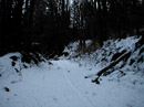
Start of Trail |
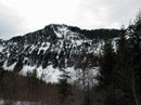
South Bessemer Mt. |
Thin Snow |
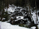
Granite Creek |
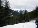
Above Granite Valley |
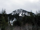
Mt. Teneriffe |
Web Mountain |
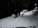
Group |
Mailbox And Si |
Photo Page 2