8-14-04
I have been up the Perry Creek
Trail three times. Each time it was to summit Mt. Forgotten. Time really
flies as my last time up was nine years ago. For the last half dozen years
I have wanted to scramble up Stillaguamish Peak. After putting it off year
after year I was determined to scramble up this year. I had hoped to have
Suzanne come along but she had a last minute work requirement so I set off
to do it alone. The forecast was for higher temperatures at the Cascade crest
than in Seattle. Stevens Pass was supposed to reach 88 degrees. Thundershowers
were possible in the afternoon. I hoped to get up the mountain before the
heat of the day and off before any lightning. I reached the Perry Creek trailhead
at 8:20 and was on the trail ten minutes later. It was already warm and
seemed more humid than normal. I made good time up the valley, reaching
the falls and creek crossing in 50 minutes. Two guys went on by me after
the creek. I guess good time is a relative term.
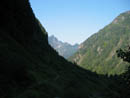
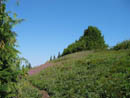
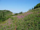
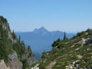
When I was within a few hundred feet of the ridge top I saw a sketchy trail heading up to the left. I figured I would hit the way trail to Stillaguamish fairly soon and indeed I did. I was expecting a faint route and I came upon a real trail. In fact, for the most part the trail was easy to follow nearly to the summit. It even had a few switchbacks. I would have to say that the way trail is narrower but better than the Perry Creek Trail. The route moved form trees to open slopes and back at first. There were blueberries and huckleberries in this stretch. They were either ripe or within a week or two at most. The trail climbs at a moderate rate and soon neared the ridge top. All the flowers were finished except for several slopes of blazing fireweed. As I rose above the forest the views really started. Mt. Dickerman was across the valley. Big Four and Hall Peak were just to the south. When I crested the ridge Mt. Forgotten loomed close by to the north.
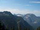
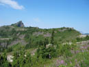
When I was on Mt. Dickerman last year I made a point of taking a photo of the ridge to Stillaguamish Peak. At full resolution I had a good view of what I was going to see. Still, a flat photo did not prepare me for the reality. The trail traverses through heather meadows with some white granite rocks. It was much more beautiful than I expected. Higher up more mountains came into view. Whitehorse and Three Fingers to the northwest. Whitechuck and Pugh to the northeast. Sloan Peak and the Monte Cristo Peaks were to the east. Vesper, Sperry, Morningstar and Del Campo also came into view. By this time I had left the last of the shade and the temperature was skyrocketing. At Stevens Pass (4000') it reached 89 degrees at 12:00 noon. On top of the heat was some of the worst humidity I have encountered in the mountains. I just could not evaporate enough sweat to cool down. I am lousy in the heat to begin with so this only made it worse.
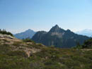
The summit came into view and I could see that it's a considerable distance along the ridge and over to it. The going was still easy when I reached a deep notch in the ridge. There were thick trees here and I could not see the bottom. The trail dropped to the left of rock and I followed it down. On the way back I found it easier to climb up the rocks. Several switchbacks later I was at the bottom. The route began immediately to climb up the other side through more heather. I soon reached a switchback and followed it to the right. All of a sudden the route ended. Above was steep rock and on either side were trees and heather. I tried going right and found nothing. I went left and it was too steep. Good routes do not simply end like that. I decided to continue left and descend. A few moments later I dropped back onto a nice trail. I solved this problem on the way down. At the switchback the real route continues around a big rock. The route soon emerged on gentler slopes above a basin with a tarn. That was the first water I saw since Perry Creek.
The route soon topped out on the south ridge of Stillaguamish. I was out of gas here and had to stop for food even though I was only about 200' below the summit. From there I scanned the slope to try to find the route up. The trail ended and there was a sketchy scramble route down to a gully. The top of the gully was a notch I would have to cross. I dropped down and then climbed along the side of the gully to near the top where I could now see a route on the other side. On the way back I went across the top of the ridge and climbed up out of the notch. From the top I dropped easily down the grassy slope and met the trail just before it hit the ridge top. I found several easier sections on my return.
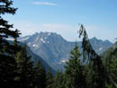
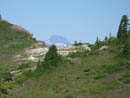
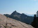
After crossing the gully at the top I was on a narrow route that crossed a very steep rock section. It almost looked like it was dug/blasted out. After this section I lost the route and headed straight up a scree and grass slope towards what I hoped was the summit. Part way up I again hit a boot path and followed it up. I missed a left turn and ended up scrambling straight up to the summit. On the way down I again took an easier less steep route. The summit proved to be quite large and nearly flat. By now I was seriously dehydrated even after drinking nearly two quarts of water. I could only get down a little more food and took many summit photos. A few clouds were now blowing in giving me a little brief shade. The view is outstanding from the summit. Even Glacier Peak and Mt. Baker were seen now. Between Mt. Pugh and Whitechuck Mt. there was one narrow smoke plume reaching high in the sky. It looked to be in the Suiattle River area. After less than 30 minutes on top I was ready to head down.
I was not feeling very well and the hike down was less fun than I had hoped. More clouds came in and blunted the sun but seemed to increase the humidity. When I was within about 1/4 mile of where I reached the way trail I passed a group of 5 who were heading for Stillaguamish. I had scanned the register and it looked like about 15 groups have been up this year. The only names I recognized from this year were the author Malcolm Bates and Steve Fox. After dropping down to the Perry Creek trail I noticed how much more beat up it is than the way trail. It was not much fun dropping down to the creek. At the creek I met a young couple who had planned to hike to the meadows but left late and were not going beyond the creek. They graciously offered me one of the two liters they had left. This was a great help. I was soon off for the last two miles to the trailhead. I was very glad to see this trip come to an end.
The way trail was much better than I expected. The scramble did have exposure and I would not recommend it to a casual hiker. Still anyone could get to the ridge just below the summit. The upper meadows were glorious and I would love see them when the flowers are blooming. I will come back on a nice 75 degree summer day in the future. Over all, this was a fun scramble. For the day I hiked 10 miles with about 3800' gained. The way trail goes for about 1.8 miles to the summit of Stillaguamish Peak.
Click on thumbnails to get larger pictures.
Photo Page 2
Trips - 2004
Home
When I was within a few hundred feet of the ridge top I saw a sketchy trail heading up to the left. I figured I would hit the way trail to Stillaguamish fairly soon and indeed I did. I was expecting a faint route and I came upon a real trail. In fact, for the most part the trail was easy to follow nearly to the summit. It even had a few switchbacks. I would have to say that the way trail is narrower but better than the Perry Creek Trail. The route moved form trees to open slopes and back at first. There were blueberries and huckleberries in this stretch. They were either ripe or within a week or two at most. The trail climbs at a moderate rate and soon neared the ridge top. All the flowers were finished except for several slopes of blazing fireweed. As I rose above the forest the views really started. Mt. Dickerman was across the valley. Big Four and Hall Peak were just to the south. When I crested the ridge Mt. Forgotten loomed close by to the north.
When I was on Mt. Dickerman last year I made a point of taking a photo of the ridge to Stillaguamish Peak. At full resolution I had a good view of what I was going to see. Still, a flat photo did not prepare me for the reality. The trail traverses through heather meadows with some white granite rocks. It was much more beautiful than I expected. Higher up more mountains came into view. Whitehorse and Three Fingers to the northwest. Whitechuck and Pugh to the northeast. Sloan Peak and the Monte Cristo Peaks were to the east. Vesper, Sperry, Morningstar and Del Campo also came into view. By this time I had left the last of the shade and the temperature was skyrocketing. At Stevens Pass (4000') it reached 89 degrees at 12:00 noon. On top of the heat was some of the worst humidity I have encountered in the mountains. I just could not evaporate enough sweat to cool down. I am lousy in the heat to begin with so this only made it worse.
The summit came into view and I could see that it's a considerable distance along the ridge and over to it. The going was still easy when I reached a deep notch in the ridge. There were thick trees here and I could not see the bottom. The trail dropped to the left of rock and I followed it down. On the way back I found it easier to climb up the rocks. Several switchbacks later I was at the bottom. The route began immediately to climb up the other side through more heather. I soon reached a switchback and followed it to the right. All of a sudden the route ended. Above was steep rock and on either side were trees and heather. I tried going right and found nothing. I went left and it was too steep. Good routes do not simply end like that. I decided to continue left and descend. A few moments later I dropped back onto a nice trail. I solved this problem on the way down. At the switchback the real route continues around a big rock. The route soon emerged on gentler slopes above a basin with a tarn. That was the first water I saw since Perry Creek.
The route soon topped out on the south ridge of Stillaguamish. I was out of gas here and had to stop for food even though I was only about 200' below the summit. From there I scanned the slope to try to find the route up. The trail ended and there was a sketchy scramble route down to a gully. The top of the gully was a notch I would have to cross. I dropped down and then climbed along the side of the gully to near the top where I could now see a route on the other side. On the way back I went across the top of the ridge and climbed up out of the notch. From the top I dropped easily down the grassy slope and met the trail just before it hit the ridge top. I found several easier sections on my return.
After crossing the gully at the top I was on a narrow route that crossed a very steep rock section. It almost looked like it was dug/blasted out. After this section I lost the route and headed straight up a scree and grass slope towards what I hoped was the summit. Part way up I again hit a boot path and followed it up. I missed a left turn and ended up scrambling straight up to the summit. On the way down I again took an easier less steep route. The summit proved to be quite large and nearly flat. By now I was seriously dehydrated even after drinking nearly two quarts of water. I could only get down a little more food and took many summit photos. A few clouds were now blowing in giving me a little brief shade. The view is outstanding from the summit. Even Glacier Peak and Mt. Baker were seen now. Between Mt. Pugh and Whitechuck Mt. there was one narrow smoke plume reaching high in the sky. It looked to be in the Suiattle River area. After less than 30 minutes on top I was ready to head down.
I was not feeling very well and the hike down was less fun than I had hoped. More clouds came in and blunted the sun but seemed to increase the humidity. When I was within about 1/4 mile of where I reached the way trail I passed a group of 5 who were heading for Stillaguamish. I had scanned the register and it looked like about 15 groups have been up this year. The only names I recognized from this year were the author Malcolm Bates and Steve Fox. After dropping down to the Perry Creek trail I noticed how much more beat up it is than the way trail. It was not much fun dropping down to the creek. At the creek I met a young couple who had planned to hike to the meadows but left late and were not going beyond the creek. They graciously offered me one of the two liters they had left. This was a great help. I was soon off for the last two miles to the trailhead. I was very glad to see this trip come to an end.
The way trail was much better than I expected. The scramble did have exposure and I would not recommend it to a casual hiker. Still anyone could get to the ridge just below the summit. The upper meadows were glorious and I would love see them when the flowers are blooming. I will come back on a nice 75 degree summer day in the future. Over all, this was a fun scramble. For the day I hiked 10 miles with about 3800' gained. The way trail goes for about 1.8 miles to the summit of Stillaguamish Peak.
Hall Peak |
Big Four Mountain |
View South |
Mt. Forgotten |
Meadow Walk |
Fireweed |
Stillaguamish Peak |
Whitehorse Mountain |
Whitechuck Mountain |
Mt. Forgotten |
Photo Page 2
Trips - 2004
Home