4/29-30/06
Last year in February I hiked to the summit of Iron
Peak and had a spectacular sunrise and sunset. I convinced Trail Pair
to join me for another attempt. The weather forecast was great at the beginning
of the week but began to deteriorate daily. By Friday evening it was looking
like mostly cloudy with scattered showers and 20 mph winds gusting to
35. Sunday looked to be beautiful. With some reservations we decided
to go for it.
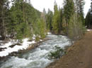
The NF Teanaway Road was checked early in the week and declared impassable 3/4 of a mile after the end of pavement. In fact it was now a little snowy in the usually spot but easily passable to the Stafford Road. We parked there and started walking. A few small snow patches and the road was bare again. Bob went back for the car and we drove on past the old Guard Station to the bridged side road over the river. That reduced the road walk by about 3 miles round trip.
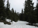
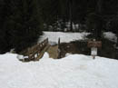
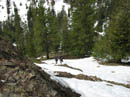
The overnight temperature did not get below freezing and the snow on the road was softening. At Beverly Creek we turned right and uphill. It was soon soft enough that we chose to put on snowshoes. Soon there were a few large bare sections of the road. We came to a large tree across the road. It is at least two feet in diameter. Considering that this was a good winter for snow I was surprised to see how little there was in the Teanaway for the end of April. At the summer parking lot there was a complete snow cover but the wooden bridge was completely snow free.
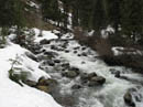
We continued up the Beverly Creek Trail reaching Bean Creek in about a half mile. Friday was 81 degrees in Cle Elum and it did not freeze overnight. The creek was very high. I think we could have made it across but our boots would have been waterlogged. Not the way to start a weekend backpacking trip. We fell back to Plan B which I considered on the drive over. The ridge starting at Bean Creek climbs steeply and continues to the summit of 7036' Earl Peak. There is a trail which crosses the ridge at about 6100'. That might make a good campsite.
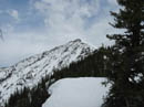
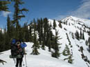
We decided on Earl and headed up the partly snow covered partly grassy ridge. We soon decided that it would be easier in boots than with snowshoes. Hiking up the road I was able to see that the south side of the ridge was mostly bare. I have scrambled the ridge before but not with so much snow higher up and not with a 39 lb. winter pack. It was interesting. Often we could stay on the ridge top. Often we dropped down, usually to snow on the north side to get through.
The first time I scrambled the ridge we were hiking the Bean Creek Trail and could not get across the Bean Creek crossing. We scrambled straight up the slope to the ridge top and then on to Earl. Hiking along the ridge top this day we suddenly found fresh footprints. Someone else must have done what I did years back. With the Teanaway road only part open and the poor weather report I did not expect to find someone else on this seldom hiked ridge this day.
We came upon snowshoes and a dog pack. The hiker was not present. We were enjoying the steps in the snow and hoping the hiker was going to continue to ease our way. It was not to be as the hiker was soon spotted enjoying the view from a rock on the ridge. As we neared this person asked if I was Jim. To find a person on this ridge this day who recognized me was unbelievable. It turned out to be Tazz from nwhikers.net. We had not met but she recognized me from photos.
We had a nice chat. Amazing who you can run into off trail in the mountains. Tazz was turning around so we were now back to kicking our own steps. The route was now completely on snow. A break in the trees gave us a view of Earl Peak. The ridge has a bend in it so we could look "around the corner" to the peak. It was still quite a distance away. I recalled that there was a spot where one has to drop down to the right to avoid cliffs before regaining the ridge. I was concerned that bad snow or cornices might but an end to our adventure.
In fact there were several long traverses to be made. The snow was soft and with our heavy packs Bob and I fell through several times. The conditions made for slow going. We successfully made each traverse and were back on the ridge looking right at Earl Peak. We were in agreement that we would rather take our chances with crossing Bean Creek than to scramble back down the ridge.
We were all about out of gas as we neared the saddle where the summer trails cross over. It was getting a bit windy now and a sheltered campsite took priority. Still I thought that the saddle would not have any views. Before reaching the saddle we crossed over the top of a 6200' high point. Just below the ridge was a flat enough area to fit our two tents. Some trees behind the site provided additional wind blocking. We decided to stop here. Our days hike was only about 5 1/2 miles but gained 3800', most of it off trail.
We shoveled out flat sites and put up our tents. 25 feet from our tents was the ridge top and great views of Earl and numerous other peaks. I wouldn't find out how good the view was until the morning. It was largely cloudy now and we were above much of the clouds. Mt. Stuart came partly out of the clouds a few times but was not totally visible. After dinner the wind picked up and some light snow fell. We felt fortunate not to have had any rain fall on us this day.
It was 35 degrees and the wind was howling when we went to bed. The wind blew most of the night. Our twin Hilleberg Nallo 3s held rock solid though great site selection played a large part. 50' either side of us the trees were bending back and forth. A 1:00 AM check showed it was now below freezing inside my tent. At 4:15 we were all awake the the wind had died. At 5:30 I reluctantly put on all my clothing and ventured out at first light. The thermometer on Bob's pack, under a pack cover read 18 degrees. A couple of minutes of uncovered fingers to take photos lead to numbness.
The photos were worth the discomfort. There was not a cloud in the sky and the view from 6200' was as good as I have ever seen. Mt. Stuart was now crystal Clear. I saw the light hit Stuart, then Bean and Mary Peak. I could just see the summit of Iron Peak bathed in bright white light. Now I could see all the other peaks that were hidden the night before. Rainier and Adams were clear. Most all the Teanaway Peaks were visible. It was quite spectacular. I managed to stay out until well after 6:00 before diving back into my sleeping bag.
Bob and Kolleen were up by 7:30 having breakfast so I grudgingly came back outside. With sun on the campsite it was warming rapidly. It was already up to 30 degrees. Breaking camp took some time. The snow was now rock hard ice. It took a lot of chipping to get stakes and snow anchors out of the ice. By 9:30 we were packed and ready to head up Earl Peak. The evening before we walked over to the saddle. It was very sheltered by trees but had no views of peaks.
With the hard ice we needed crampons to get up Earl. The icy snow was good for traction as we walked right up the south ridge. It was the steepest slope I have used crampons on. It was so hard that our ice axes barely made a dent. A slow steady 50 minute ascent brought us to the summit of Earl. As we rose the views improved and I kept stopping to shoot more photos. At the top we added Navaho, Three Brothers, and Miller Peak to the sea of summits we had been enjoying.
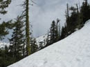
It was now clear enough to see Hibox, Alta, and Three Queens far to the west. It was only 10:30 and there was not a hint of haze in the air. The wind was very cold on the summit and we made our stay short. We dropped down the north side towards the ridge leading over to Bean Peak. We had to crampon through some rocks but once back on snow the going was good. This side had only recently received sunshine and the icy snow was very hard. we worked our way down the ridge to where it flattens before heading over to Bean Peak.
We had discussed climbing Bean but with the wind we decided to head on down. We found a good open slope and started down. The snow quickly became awful. Not hard enough for good cramponing but not soft enough to glissade. We found our feet sliding rather than sticking to the slope. Visions of sliding at ever faster speeds into the trees hundreds of feet below came to mind. It was bad enough we chose to face into the slope and kick steps down. Tedious but safer than taking a long slide.
Much lower down the conditions improved and we were able to walk down to the basin. The wind was minimal and the sun was very warm. Crampons came off and we booted it down through Bean Creek Basin. There were some faint ski tracks we followed much of the way down. There is an open avalanche swath with a creek, dry most of the summer, cutting through it. I have never had a problem here but now it was a steep drop to the creek and a steep climb up the other side. There were a few snow bridges but they looked weak.
As I was climbing down to ford the creek Kolleen called and I saw Bob cross a very small snow bridge. With a 40 lb. pack on I was surprised to see it held him. Well, if it worked for Bob... I crossed as well though not comfortably. Not much farther down we came to the crossing of Bean Creek. There was a large group of skiers and snowshoers on the other side. They were cutting steps down to the creek.
With such a short distance yet to go I could not care less about getting across with dry feet. I jumped into the creek and waded across. That was the last problem on our descent. From there on it was just a snow slog. The road had melted out considerably since the previous morning. We were glad to get a few sections of Terra Firma to walk on. We were back at the car before 3:00.
This turned out to be a great backpacking trip. We had roaring winds, sub 20 degree cold, clouds blowing all around us, and some of the most crystal clear mountain views I have ever had the privilege of seeing. We didn't end up where we had originally planned but almost everything else worked out great.
Click on thumbnails to get larger pictures.
Photo Page 2
Trips - 2006
Home
The NF Teanaway Road was checked early in the week and declared impassable 3/4 of a mile after the end of pavement. In fact it was now a little snowy in the usually spot but easily passable to the Stafford Road. We parked there and started walking. A few small snow patches and the road was bare again. Bob went back for the car and we drove on past the old Guard Station to the bridged side road over the river. That reduced the road walk by about 3 miles round trip.
The overnight temperature did not get below freezing and the snow on the road was softening. At Beverly Creek we turned right and uphill. It was soon soft enough that we chose to put on snowshoes. Soon there were a few large bare sections of the road. We came to a large tree across the road. It is at least two feet in diameter. Considering that this was a good winter for snow I was surprised to see how little there was in the Teanaway for the end of April. At the summer parking lot there was a complete snow cover but the wooden bridge was completely snow free.
We continued up the Beverly Creek Trail reaching Bean Creek in about a half mile. Friday was 81 degrees in Cle Elum and it did not freeze overnight. The creek was very high. I think we could have made it across but our boots would have been waterlogged. Not the way to start a weekend backpacking trip. We fell back to Plan B which I considered on the drive over. The ridge starting at Bean Creek climbs steeply and continues to the summit of 7036' Earl Peak. There is a trail which crosses the ridge at about 6100'. That might make a good campsite.
We decided on Earl and headed up the partly snow covered partly grassy ridge. We soon decided that it would be easier in boots than with snowshoes. Hiking up the road I was able to see that the south side of the ridge was mostly bare. I have scrambled the ridge before but not with so much snow higher up and not with a 39 lb. winter pack. It was interesting. Often we could stay on the ridge top. Often we dropped down, usually to snow on the north side to get through.
The first time I scrambled the ridge we were hiking the Bean Creek Trail and could not get across the Bean Creek crossing. We scrambled straight up the slope to the ridge top and then on to Earl. Hiking along the ridge top this day we suddenly found fresh footprints. Someone else must have done what I did years back. With the Teanaway road only part open and the poor weather report I did not expect to find someone else on this seldom hiked ridge this day.
We came upon snowshoes and a dog pack. The hiker was not present. We were enjoying the steps in the snow and hoping the hiker was going to continue to ease our way. It was not to be as the hiker was soon spotted enjoying the view from a rock on the ridge. As we neared this person asked if I was Jim. To find a person on this ridge this day who recognized me was unbelievable. It turned out to be Tazz from nwhikers.net. We had not met but she recognized me from photos.
We had a nice chat. Amazing who you can run into off trail in the mountains. Tazz was turning around so we were now back to kicking our own steps. The route was now completely on snow. A break in the trees gave us a view of Earl Peak. The ridge has a bend in it so we could look "around the corner" to the peak. It was still quite a distance away. I recalled that there was a spot where one has to drop down to the right to avoid cliffs before regaining the ridge. I was concerned that bad snow or cornices might but an end to our adventure.
In fact there were several long traverses to be made. The snow was soft and with our heavy packs Bob and I fell through several times. The conditions made for slow going. We successfully made each traverse and were back on the ridge looking right at Earl Peak. We were in agreement that we would rather take our chances with crossing Bean Creek than to scramble back down the ridge.
We were all about out of gas as we neared the saddle where the summer trails cross over. It was getting a bit windy now and a sheltered campsite took priority. Still I thought that the saddle would not have any views. Before reaching the saddle we crossed over the top of a 6200' high point. Just below the ridge was a flat enough area to fit our two tents. Some trees behind the site provided additional wind blocking. We decided to stop here. Our days hike was only about 5 1/2 miles but gained 3800', most of it off trail.
We shoveled out flat sites and put up our tents. 25 feet from our tents was the ridge top and great views of Earl and numerous other peaks. I wouldn't find out how good the view was until the morning. It was largely cloudy now and we were above much of the clouds. Mt. Stuart came partly out of the clouds a few times but was not totally visible. After dinner the wind picked up and some light snow fell. We felt fortunate not to have had any rain fall on us this day.
It was 35 degrees and the wind was howling when we went to bed. The wind blew most of the night. Our twin Hilleberg Nallo 3s held rock solid though great site selection played a large part. 50' either side of us the trees were bending back and forth. A 1:00 AM check showed it was now below freezing inside my tent. At 4:15 we were all awake the the wind had died. At 5:30 I reluctantly put on all my clothing and ventured out at first light. The thermometer on Bob's pack, under a pack cover read 18 degrees. A couple of minutes of uncovered fingers to take photos lead to numbness.
The photos were worth the discomfort. There was not a cloud in the sky and the view from 6200' was as good as I have ever seen. Mt. Stuart was now crystal Clear. I saw the light hit Stuart, then Bean and Mary Peak. I could just see the summit of Iron Peak bathed in bright white light. Now I could see all the other peaks that were hidden the night before. Rainier and Adams were clear. Most all the Teanaway Peaks were visible. It was quite spectacular. I managed to stay out until well after 6:00 before diving back into my sleeping bag.
Bob and Kolleen were up by 7:30 having breakfast so I grudgingly came back outside. With sun on the campsite it was warming rapidly. It was already up to 30 degrees. Breaking camp took some time. The snow was now rock hard ice. It took a lot of chipping to get stakes and snow anchors out of the ice. By 9:30 we were packed and ready to head up Earl Peak. The evening before we walked over to the saddle. It was very sheltered by trees but had no views of peaks.
With the hard ice we needed crampons to get up Earl. The icy snow was good for traction as we walked right up the south ridge. It was the steepest slope I have used crampons on. It was so hard that our ice axes barely made a dent. A slow steady 50 minute ascent brought us to the summit of Earl. As we rose the views improved and I kept stopping to shoot more photos. At the top we added Navaho, Three Brothers, and Miller Peak to the sea of summits we had been enjoying.
It was now clear enough to see Hibox, Alta, and Three Queens far to the west. It was only 10:30 and there was not a hint of haze in the air. The wind was very cold on the summit and we made our stay short. We dropped down the north side towards the ridge leading over to Bean Peak. We had to crampon through some rocks but once back on snow the going was good. This side had only recently received sunshine and the icy snow was very hard. we worked our way down the ridge to where it flattens before heading over to Bean Peak.
We had discussed climbing Bean but with the wind we decided to head on down. We found a good open slope and started down. The snow quickly became awful. Not hard enough for good cramponing but not soft enough to glissade. We found our feet sliding rather than sticking to the slope. Visions of sliding at ever faster speeds into the trees hundreds of feet below came to mind. It was bad enough we chose to face into the slope and kick steps down. Tedious but safer than taking a long slide.
Much lower down the conditions improved and we were able to walk down to the basin. The wind was minimal and the sun was very warm. Crampons came off and we booted it down through Bean Creek Basin. There were some faint ski tracks we followed much of the way down. There is an open avalanche swath with a creek, dry most of the summer, cutting through it. I have never had a problem here but now it was a steep drop to the creek and a steep climb up the other side. There were a few snow bridges but they looked weak.
As I was climbing down to ford the creek Kolleen called and I saw Bob cross a very small snow bridge. With a 40 lb. pack on I was surprised to see it held him. Well, if it worked for Bob... I crossed as well though not comfortably. Not much farther down we came to the crossing of Bean Creek. There was a large group of skiers and snowshoers on the other side. They were cutting steps down to the creek.
With such a short distance yet to go I could not care less about getting across with dry feet. I jumped into the creek and waded across. That was the last problem on our descent. From there on it was just a snow slog. The road had melted out considerably since the previous morning. We were glad to get a few sections of Terra Firma to walk on. We were back at the car before 3:00.
This turned out to be a great backpacking trip. We had roaring winds, sub 20 degree cold, clouds blowing all around us, and some of the most crystal clear mountain views I have ever had the privilege of seeing. We didn't end up where we had originally planned but almost everything else worked out great.
Teanaway River |
Beverly Creek Road |
Beverly Trailhead |
Beverly Creek |
Starting Up Ridge |
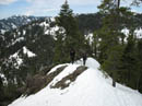
Ridge Top |
First Look At Earl |
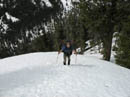
Bob Ascending |
Aiming For Earl |
Kolleen On Rdige |
Photo Page 2
Trips - 2006
Home