5-13-06
Each spring the swallows return to San Juan Capistrano,
the buzzards return to Hinkley, Ohio, and I return to Iron Peak. This year
proved to be no different. Two weeks earlier I had hoped to camp on the
summit once again. Very high water at Bean Creek and strong all night winds
caused us to change our campsite to high on Earl Peak. On this trip Suzanne
and Sadie came along again and Bernadette made a first spring scramble ascent
of the peak. We were out of Seattle by 6:30 am.
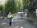
Two weeks earlier we had to park at the bridge across the Teanaway just beyond the old guard station. This time we were able to drive to Beverly Creek Road and well up it. The big tree across Beverly Creek Road is now off to the side. Where the road crosses Beverly Creek on a big culvert we were stopped. Three other vehicles were already there and another arrived just after us.
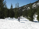
There is a good sized snow patch beyond the culvert which will stop wheels for another week or so. Much of the road beyond there is bare. The trailhead parking lot was under 12-18 inches of snow two weeks earlier and now is completely bare. Snow begins just across Beverly Creek. We were on our way by about 8:45 and had only a 1/2 mile walk to the trailhead. It was down to freezing over night and the snow was firm. Another 1/2 mile and we reached Bean Creek.
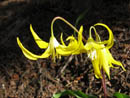
The water level was much lower than two weeks earlier. Still too high to get across with dry boots but no longer thigh deep. We switched to other shoes to make the crossing. On the other side we put our dry boots back on. There were some ski tracks still visible in the hard snow. The ground on the other side of Bean Creek gets lots of sun and melts out early. It was completely snow free. Many glacier lilies dotted the grassy slope.
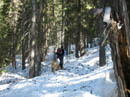
Within a few minutes we were back on snow and would remain so for most of the day. The next section is in thick forest and the snow was much harder. Traction was tenuous though we didn't bother with crampons. Poles were very helpful. Navigation is easy through here. Stay well above the creek but don't venture up the slope. The one open talus field along there was still under snow. The forecast was for partly cloudy but as we came out of the forest there was still not a cloud in the sky.
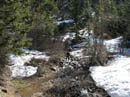
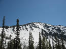
The summer trail switchbacks up the slope before heading up the valley. In spring the snow covers all the rocks and brush making it easy to just follow the creek. Higher up the valley Bill Peak came into view. It was quite impressive with lots of snow still coating the peak. I usually follow the creek up to near the Fourth Creek trail junction before crossing. This time we found a snow bridge well down the valley. This was the lowest I have crossed the creek.
Rather than crossing the creek and heading straight up Iron we were able to make a gradual rising traverse. The snow was firm but not icy and the forest open enough to allow easy progress. As we rose we could begin to see peaks of the Stuart Range over Fourth Creek Pass. By now I was down to short sleeves and it was feeling comfortably warm. Teanaway Peak came into view and I set a course straight towards it.
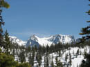
The summer trail reaches the ridge of Iron at a low pass at the base of Teanaway Peak. I have found it shorter and easier to head right up the face of the ridge near the summit of Iron. Most of the ridge is corniced so it is important to find one of the few places where cornices can be avoided. We reached the base of the final ridge climb and took a break. Now the views included Mt. Stuart, Dragontail, Little Annapurna, McClellan Peak, Volcanic Neck, and Bean Peak.
We switched from poles to crampons, a pole, and an ice axe. It was soft enough to kick steps at 6000' but it can get harder near the top. It's too steep up there to stop and put on crampons. I had a bite to eat and Suzanne went ahead. It was the first time I can recall someone kicking steps up that slope for me. It was much appreciated. I'm not sure Bernadette was expecting such a steep slope but she gamely followed Suzanne up. It took us about 25 minutes to climb up to the ridge. The humans that is. Sadie meandered along much of the way then scooted up to the top and waited for us there. On a steep snow slope she always switches back and forth as she climbs, leaving a ski slalom track up the slope.
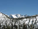
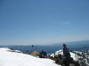
Bernadette seemed impressed as she topped out to an unbroken line of snow capped peaks from the Goat Rocks to north of Mt. Daniel. Mt. Stuart blocks due north but the view is outstanding in all other directions. We topped out within a few hundred feet of the summit. There was quite a bit more snow than when I camped there last February. It was past noon and I was ready for lunch on the summit.
I was later to learn that I had accidentally moved the mode wheel on my camera and many photos of the ascent and the summit were lost. Oh well, I guess I'll just have to come back next year. I was quite surprised to see that the summit register was in the open. All but the tops of the summit rocks were still under snow. The register is gone but I checked out scraps of paper and could not find a listing after November 2005. There were no footprints or ski tracks on the upper mountain.
Heading up is a good workout and the views are among the best, especially considering the mountain is "only" 6520'. The real fun of this trip though is the first 500' coming down. The snow conditions were ideal for glissading. A few inches of softening snow over a very hard pack. Rain pants went on and I volunteered to go first. I chose a slightly steeper spot than where we came up. I sat down and flew. It took about 12 seconds to drop 500'. When I reached the bottom I stood up, turned around, and found Sadie already reaching the bottom. She ran full tilt all the way down the slope.
Bernadette and Suzanne followed and quickly joined me. The rest of the way down to the creek we hunted for steeper slopes and managed another 3 or 4 good albeit shorter glissades. In no time we were down to Beverly Creek. We came down much higher in the basin and snow still covered most of the creek. Getting across was no problem. Once across the creek we stopped to remove extra clothing. I was down to short sleeves again.
Heading down the valley we postholed occasionally but the snow was mostly firm with great traction. We carried snowshoes up and down and never came close to needing them. The bright sun and warmth made it a real spring Teanaway trip. Back in the forest the snow was still hard but better than coming up. Bean Creek was a little higher but not as much as I expected with the afternoon heat.
At the creek we saw the same group of skiers who left just after us that morning. They were the only people we saw all day. There were a few more cars at the temporary parking lot but they all went up Bean Creek this day. I've done Iron Peak more than a few springs and have enjoyed each and every trip. This time we had excellent snow conditions, great weather, terrific views. and the usual total solitude. I'll probably be back next spring.
Click on thumbnails to get larger pictures.
Photo Page 2
Trips - 2006
Home
Two weeks earlier we had to park at the bridge across the Teanaway just beyond the old guard station. This time we were able to drive to Beverly Creek Road and well up it. The big tree across Beverly Creek Road is now off to the side. Where the road crosses Beverly Creek on a big culvert we were stopped. Three other vehicles were already there and another arrived just after us.
There is a good sized snow patch beyond the culvert which will stop wheels for another week or so. Much of the road beyond there is bare. The trailhead parking lot was under 12-18 inches of snow two weeks earlier and now is completely bare. Snow begins just across Beverly Creek. We were on our way by about 8:45 and had only a 1/2 mile walk to the trailhead. It was down to freezing over night and the snow was firm. Another 1/2 mile and we reached Bean Creek.
The water level was much lower than two weeks earlier. Still too high to get across with dry boots but no longer thigh deep. We switched to other shoes to make the crossing. On the other side we put our dry boots back on. There were some ski tracks still visible in the hard snow. The ground on the other side of Bean Creek gets lots of sun and melts out early. It was completely snow free. Many glacier lilies dotted the grassy slope.
Within a few minutes we were back on snow and would remain so for most of the day. The next section is in thick forest and the snow was much harder. Traction was tenuous though we didn't bother with crampons. Poles were very helpful. Navigation is easy through here. Stay well above the creek but don't venture up the slope. The one open talus field along there was still under snow. The forecast was for partly cloudy but as we came out of the forest there was still not a cloud in the sky.
The summer trail switchbacks up the slope before heading up the valley. In spring the snow covers all the rocks and brush making it easy to just follow the creek. Higher up the valley Bill Peak came into view. It was quite impressive with lots of snow still coating the peak. I usually follow the creek up to near the Fourth Creek trail junction before crossing. This time we found a snow bridge well down the valley. This was the lowest I have crossed the creek.
Rather than crossing the creek and heading straight up Iron we were able to make a gradual rising traverse. The snow was firm but not icy and the forest open enough to allow easy progress. As we rose we could begin to see peaks of the Stuart Range over Fourth Creek Pass. By now I was down to short sleeves and it was feeling comfortably warm. Teanaway Peak came into view and I set a course straight towards it.
The summer trail reaches the ridge of Iron at a low pass at the base of Teanaway Peak. I have found it shorter and easier to head right up the face of the ridge near the summit of Iron. Most of the ridge is corniced so it is important to find one of the few places where cornices can be avoided. We reached the base of the final ridge climb and took a break. Now the views included Mt. Stuart, Dragontail, Little Annapurna, McClellan Peak, Volcanic Neck, and Bean Peak.
We switched from poles to crampons, a pole, and an ice axe. It was soft enough to kick steps at 6000' but it can get harder near the top. It's too steep up there to stop and put on crampons. I had a bite to eat and Suzanne went ahead. It was the first time I can recall someone kicking steps up that slope for me. It was much appreciated. I'm not sure Bernadette was expecting such a steep slope but she gamely followed Suzanne up. It took us about 25 minutes to climb up to the ridge. The humans that is. Sadie meandered along much of the way then scooted up to the top and waited for us there. On a steep snow slope she always switches back and forth as she climbs, leaving a ski slalom track up the slope.
Bernadette seemed impressed as she topped out to an unbroken line of snow capped peaks from the Goat Rocks to north of Mt. Daniel. Mt. Stuart blocks due north but the view is outstanding in all other directions. We topped out within a few hundred feet of the summit. There was quite a bit more snow than when I camped there last February. It was past noon and I was ready for lunch on the summit.
I was later to learn that I had accidentally moved the mode wheel on my camera and many photos of the ascent and the summit were lost. Oh well, I guess I'll just have to come back next year. I was quite surprised to see that the summit register was in the open. All but the tops of the summit rocks were still under snow. The register is gone but I checked out scraps of paper and could not find a listing after November 2005. There were no footprints or ski tracks on the upper mountain.
Heading up is a good workout and the views are among the best, especially considering the mountain is "only" 6520'. The real fun of this trip though is the first 500' coming down. The snow conditions were ideal for glissading. A few inches of softening snow over a very hard pack. Rain pants went on and I volunteered to go first. I chose a slightly steeper spot than where we came up. I sat down and flew. It took about 12 seconds to drop 500'. When I reached the bottom I stood up, turned around, and found Sadie already reaching the bottom. She ran full tilt all the way down the slope.
Bernadette and Suzanne followed and quickly joined me. The rest of the way down to the creek we hunted for steeper slopes and managed another 3 or 4 good albeit shorter glissades. In no time we were down to Beverly Creek. We came down much higher in the basin and snow still covered most of the creek. Getting across was no problem. Once across the creek we stopped to remove extra clothing. I was down to short sleeves again.
Heading down the valley we postholed occasionally but the snow was mostly firm with great traction. We carried snowshoes up and down and never came close to needing them. The bright sun and warmth made it a real spring Teanaway trip. Back in the forest the snow was still hard but better than coming up. Bean Creek was a little higher but not as much as I expected with the afternoon heat.
At the creek we saw the same group of skiers who left just after us that morning. They were the only people we saw all day. There were a few more cars at the temporary parking lot but they all went up Bean Creek this day. I've done Iron Peak more than a few springs and have enjoyed each and every trip. This time we had excellent snow conditions, great weather, terrific views. and the usual total solitude. I'll probably be back next spring.
Trailhead |
Bean Creek |
Glacier Lilies |
Forest |
Lower Basin |
Mary Peak |
Dragontail Peak |
Fourth Creek Pass |
Summit |
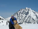
Jim & Sadie |
Photo Page 2
Trips - 2006
Home