3-12-06
Bob and Kolleen (Trail Pair) joined me for a snowshoe
trip up Mt. Teneriffe. Although it is close to North Bend the 4788' summit
seems almost alpine. It's also a heck of a good winter workout. The road
route is 14 miles with the last mile an off road ridge walk to the summit.
It gains about 4400' including two ups and down. The forecast was for partly
to mostly cloudy. The pinpoint zone forecast called for a high of 35 degrees
at 2700'. With the summit being 2000' higher we were prepared for cold.
A storm a few days earlier dumped snow as low as 500' We were prepared for
a long snowshoe slog.
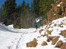
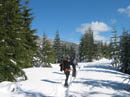
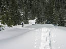
We started up the road/trail at 8:45 AM under mostly blue skies. It felt like 45 degrees already. Not a trace of snow was to be found. In fact, not for a whole lot longer. The first mile is gentle before the it gets down to the business of gaining elevation. That it does very efficiently. We climbed higher and higher on bare ground. Finally at about 2300' we found some snow. By 2600' there was enough to cover the road, though barely. Soon a snowshoe trench began. The snow was well enough packed that we did not sink at all in just boots.
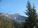
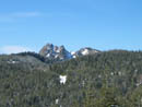
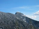
The trench deepened but was still easy going. At 3400' the route turned flat and continued to head directly away from Mt. Teneriffe. Finally it turned uphill and in a few short switchbacks we passed the turn off to Mt. Si. Not a single track led that way. The route turned right and began to head towards Mt. Teneriffe. We climbed out of the forest and had views out. Mt. Rainier was mostly clear. The route leveled at about 4000'. We had a nice clear view of the summit.
Next we began a slow gentle descent. Most snowshoers turned around here and our nice trench turned into deep footprints. Soon after we stopped to put on snowhoes. We had been playing leap frog with a solo hiker and he passed us here one last time. Several others passed us heading down and none of them went beyond the road end. This last hiker said he too would turn around at the road end saddle. It was nice to have him breaking trail. One last solo hiker passed us coming down. He was postholing to near his crotch with every step.
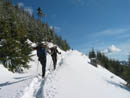
One final uphill push and we reached the saddle at 4200'. We now had clear views out to the north. With the snow it took us three hours to hike up 6 miles gaining 3400'. Half a lunch had us fueled up and ready for the final ridge hike to the summit. Trail Pair had been to the saddle but not on the ridge. Only one faint snow covered track remained beyond the saddle. We were able to follow it most of the way.
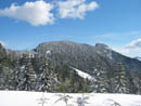
Even without tracks the ridge is not difficult. The only key is to stay very near the crest of the forested ridge. At first the ridge rises steeply from the saddle then becomes quite gentle. At the high point it drops down to another saddle and then climbs sharply to the summit. It's about one mile from the road end to the summit. When it's icy an ice axe and crampons are necessary but we had good snow this day.
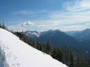
Roughly 300' of climbing brings you from the last saddle to the summit. The last section from the edge of the trees to the top was a little hard but no problem with snowshoes. The top is a short ridge. Get too close to the top and break the cornice and it's a fast ride down the vertical north side. The wind was light and we were comfortable with an extra layer on. Mt. Rainier was now lost in the clouds and Mt. Baker was also hidden. Most peaks were in the clear. Mt. Pilchuck, the Cascade Crest peaks, and all the closer peaks were out of the clouds. Downtown Seattle was in the clear. It's a neat view looking down on the top of the Mt. Si haystack.
We took four hours to reach the summit. It took a full hour to do the last mile. With fresh snow you really earn the summit. Thirty minutes on top went by very fast. Soon it was time to head down. The steep drop down to the first saddle was very fast. A slow climb back to the ridge top was followed by a very fast descent back to the road. In 35 minutes we were back at the saddle again. The last six miles was just a long snow slog broken up with many photo stops. The snow had softened considerably and we kept snowshoes on until the snow was very thin.
By the time we reached the car we all had sore feet. We took 2:45 coming down. As has been the case week after week this winter, the weather was much better than forecast. Although it snowed heavily only a few days earlier the many snowshoers on the road had packed down a nice trench making our work much easier. Still, 14 miles on a snowshoe trip is a lot of work. A lot of work and well worth the effort.
Click on thumbnails to get larger pictures.
Photo Page 2
Trips - 2006
Home
We started up the road/trail at 8:45 AM under mostly blue skies. It felt like 45 degrees already. Not a trace of snow was to be found. In fact, not for a whole lot longer. The first mile is gentle before the it gets down to the business of gaining elevation. That it does very efficiently. We climbed higher and higher on bare ground. Finally at about 2300' we found some snow. By 2600' there was enough to cover the road, though barely. Soon a snowshoe trench began. The snow was well enough packed that we did not sink at all in just boots.
The trench deepened but was still easy going. At 3400' the route turned flat and continued to head directly away from Mt. Teneriffe. Finally it turned uphill and in a few short switchbacks we passed the turn off to Mt. Si. Not a single track led that way. The route turned right and began to head towards Mt. Teneriffe. We climbed out of the forest and had views out. Mt. Rainier was mostly clear. The route leveled at about 4000'. We had a nice clear view of the summit.
Next we began a slow gentle descent. Most snowshoers turned around here and our nice trench turned into deep footprints. Soon after we stopped to put on snowhoes. We had been playing leap frog with a solo hiker and he passed us here one last time. Several others passed us heading down and none of them went beyond the road end. This last hiker said he too would turn around at the road end saddle. It was nice to have him breaking trail. One last solo hiker passed us coming down. He was postholing to near his crotch with every step.
One final uphill push and we reached the saddle at 4200'. We now had clear views out to the north. With the snow it took us three hours to hike up 6 miles gaining 3400'. Half a lunch had us fueled up and ready for the final ridge hike to the summit. Trail Pair had been to the saddle but not on the ridge. Only one faint snow covered track remained beyond the saddle. We were able to follow it most of the way.
Even without tracks the ridge is not difficult. The only key is to stay very near the crest of the forested ridge. At first the ridge rises steeply from the saddle then becomes quite gentle. At the high point it drops down to another saddle and then climbs sharply to the summit. It's about one mile from the road end to the summit. When it's icy an ice axe and crampons are necessary but we had good snow this day.
Roughly 300' of climbing brings you from the last saddle to the summit. The last section from the edge of the trees to the top was a little hard but no problem with snowshoes. The top is a short ridge. Get too close to the top and break the cornice and it's a fast ride down the vertical north side. The wind was light and we were comfortable with an extra layer on. Mt. Rainier was now lost in the clouds and Mt. Baker was also hidden. Most peaks were in the clear. Mt. Pilchuck, the Cascade Crest peaks, and all the closer peaks were out of the clouds. Downtown Seattle was in the clear. It's a neat view looking down on the top of the Mt. Si haystack.
We took four hours to reach the summit. It took a full hour to do the last mile. With fresh snow you really earn the summit. Thirty minutes on top went by very fast. Soon it was time to head down. The steep drop down to the first saddle was very fast. A slow climb back to the ridge top was followed by a very fast descent back to the road. In 35 minutes we were back at the saddle again. The last six miles was just a long snow slog broken up with many photo stops. The snow had softened considerably and we kept snowshoes on until the snow was very thin.
By the time we reached the car we all had sore feet. We took 2:45 coming down. As has been the case week after week this winter, the weather was much better than forecast. Although it snowed heavily only a few days earlier the many snowshoers on the road had packed down a nice trench making our work much easier. Still, 14 miles on a snowshoe trip is a lot of work. A lot of work and well worth the effort.
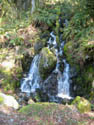
Waterfall |
Summit |
Deepening Snow |
Bright Sunshine |
Mt. Si Haystack |
Mailbox Peak |
Ascent Flattens |
Summit Ridge |
Teneriffe Summit |
Descending |
Photo Page 2
Trips - 2006
Home