7-16-06
The day before Suzanne, Kolleen, Bob, and I hiked
up Hannegan Peak. We camped at the trailhead. By 7:15 am there was movement
and by 8:30 we had eaten breakfast and broken camp. By 9:00 am we drove to
the Yellow Aster Butte - Gold Run Pass trailhead and were on the trail. Years
earlier I hiked up to Gold Run Pass and looked for the "easy slopes" to
wander up YAB as mentioned in 101 HIkes. There are no easy slopes near the
pass. After hearing all the good things about the basin, tarns, and summit
I was more than ready to get up there.
Back in February our same group snowshoed up to Welcome Pass and wandered along the ridge to just above the tarns. That only made us more interested in a summer visit. Even at 9:00 am there were at least a dozen cars at the trailhead. We expected to find backpackers in the basin. The trail begins with a few steep switchbacks before traversing out of the forest into the open. Unlike the day before, the sky was crystal clear this day. We soon had a nice look at Mt. Baker.
The old "Keep Kool" trail started at a lower elevation and steeply climbed to the the basin and tarns. I expected the new trail to leave the Gold Run Pass trail and cut over to the old trail. It does no such thing. The whole route to YAB is new (relatively). The route was mostly in forest which was nice for the descent as the day warmed up. There were several large trees down but they were not too tough to go over or under.
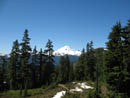
There was some mud in the meadows and we reached some small snow patches which will be gone very soon. Not far below Gold Run Pass the route turns off to the left. It contours around the head of the valley and slowly climbs under YAB. This route provides great views out to Mt. Baker and Mt. Shuksan as well as other peaks to the south. We had a directly opposite view of Goat Mountain compared to the day before on Hannegan Peak. Wildflowers were everywhere. The slopes were green with some rock and lots of colorful flowers. This is the perfect time to do this hike.
The route turned into a small rocky basin and crossed a creek. There was still snow here. We dropped a bit and climbed up partly on snow. The footing was good and gaiters were not needed. Soon we were back on dirt and turned from south to west as we contoured around YAB. There were some bugs but even with the flowers they never became much of a bother. It looked much different than we expected but we picked out the point where we turned around in February. It looked to be a pointed peak from this angle though it was just the end of a long broad ridge coming from Welcome Pass.
As we rose more and more peaks came into view. The trail soon reached a split and we turned right and began the climb up the butte. Bob and Kolleen had been here before in later season but not with snow. The route meandered gently before getting down to some serious elevation gain. We were moving slowly taking many photos and another group passed by us. The last climb was pretty steep but a boot path continued all the way to the top.
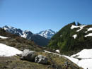
At least we thought it was the top. Suzanne and I were ahead and didn't realize what Bob and Kolleen knew. This was a false summit. There was plenty of room and the views were outstanding but we could see a slightly higher point to the north. Speaking of views, they really are tremendous. Tomyhoi Peak towers above to the northwest. North and northeast are Canadian Border Peak, American Border Peak, and Mt. Larrabee. Shuksan and Baker dominate to the south. Even the top of Mt. Rainier was visible.
I had a quick sandwich and when Bob and Kolleen arrived we were quickly off to the real summit. The group who passed us were ahead on the same route. There is a boot path which drops off the north side to a saddle, goes over a smooth bump, and then climbs to the summit. The drop was steep but easy. As we hiked along the ridge we scouted for a possible drop into the basin for our return. It was mostly snow with a good deal of talus and heather as well.
The summit appeared to be small and we were concerned that the four hikers and a dog would not leave much room on top for us four and two dogs. We decided to head on up and hope for the best. The scramble route is not bad as the path does continue all the way to the top. Lots more wildflowers adorned the summit. The very top is big enough for two or three to sit but just below is plenty of room. We had no problem with 8 hikers and 3 dogs. The two groups took photos with each others cameras so we all had a photo of ourselves at the true summit.
Now it was time for a well earned lunch. To the previous views we added Tomyhoi Lake far below us to the north of Gold Run Pass. The other group mentioned an interest in dropping into the basin from the ridge so we stayed on the summit to watch their route. They did not have ice axes and were conservative. They did manage a little glissading with mostly plunge stepping.
We then dropped back to the ridge and followed it farther than the other group. We passed over the bump and stopped at the low point. It was steep and harder than I expected. Still it was easy to self arrest. Directly below us was a big patch of talus. I slowly glissaded down and the others followed. A downward traverse on snow brought us to another open slope. This time Bob went first. I went much faster here but still had to stop before hitting more talus. One more snow traverse and a final longer glissade brought us down to the basin.
Many of the tarns are still under snow and a few are mostly open though with snow around them. The snow firm and not deep enough for any post holing. We caught up with the other group at a melted out tarn. Their dog Chavez and our Clover still had the energy to tear after each other all over the snowy basin. Sadie had the good sense to take a dip in the frigid water. The basin is extremely scenic with the snow and peaks all around. I would love to camp there this time of year.
Leaving the basin required a 200' climb up a grassy slope covered with more wildflowers. At the top we completed the route where the false summit trail turned off. The hike down was lots of fun. The peaks were laid out all around us. The wildflowers covered the hillside. The crowds converged. I was really surprised how many people we met still coming up in mid afternoon on a Sunday. We passed many groups. We really had not seen that many people until the descent. The hike out seemed much longer than the stated mileage.
We were back at our cars by about the same time we left the summit of Hannegan Peak the day before. For the day we covered about 9 miles with 3200' gained. It turned out to be a terrific weekend. They were the third and fourth new trips for me in a row. It has been many years since I have done that. The first day was cloudy but the second day more than made up for it. Both hikes had very good wildflowers. I need to spend more time in the far North Cascades.
Click on thumbnails to get larger pictures.
Photo Page 2
Trips - 2006
Home
Back in February our same group snowshoed up to Welcome Pass and wandered along the ridge to just above the tarns. That only made us more interested in a summer visit. Even at 9:00 am there were at least a dozen cars at the trailhead. We expected to find backpackers in the basin. The trail begins with a few steep switchbacks before traversing out of the forest into the open. Unlike the day before, the sky was crystal clear this day. We soon had a nice look at Mt. Baker.
The old "Keep Kool" trail started at a lower elevation and steeply climbed to the the basin and tarns. I expected the new trail to leave the Gold Run Pass trail and cut over to the old trail. It does no such thing. The whole route to YAB is new (relatively). The route was mostly in forest which was nice for the descent as the day warmed up. There were several large trees down but they were not too tough to go over or under.
There was some mud in the meadows and we reached some small snow patches which will be gone very soon. Not far below Gold Run Pass the route turns off to the left. It contours around the head of the valley and slowly climbs under YAB. This route provides great views out to Mt. Baker and Mt. Shuksan as well as other peaks to the south. We had a directly opposite view of Goat Mountain compared to the day before on Hannegan Peak. Wildflowers were everywhere. The slopes were green with some rock and lots of colorful flowers. This is the perfect time to do this hike.
The route turned into a small rocky basin and crossed a creek. There was still snow here. We dropped a bit and climbed up partly on snow. The footing was good and gaiters were not needed. Soon we were back on dirt and turned from south to west as we contoured around YAB. There were some bugs but even with the flowers they never became much of a bother. It looked much different than we expected but we picked out the point where we turned around in February. It looked to be a pointed peak from this angle though it was just the end of a long broad ridge coming from Welcome Pass.
As we rose more and more peaks came into view. The trail soon reached a split and we turned right and began the climb up the butte. Bob and Kolleen had been here before in later season but not with snow. The route meandered gently before getting down to some serious elevation gain. We were moving slowly taking many photos and another group passed by us. The last climb was pretty steep but a boot path continued all the way to the top.
At least we thought it was the top. Suzanne and I were ahead and didn't realize what Bob and Kolleen knew. This was a false summit. There was plenty of room and the views were outstanding but we could see a slightly higher point to the north. Speaking of views, they really are tremendous. Tomyhoi Peak towers above to the northwest. North and northeast are Canadian Border Peak, American Border Peak, and Mt. Larrabee. Shuksan and Baker dominate to the south. Even the top of Mt. Rainier was visible.
I had a quick sandwich and when Bob and Kolleen arrived we were quickly off to the real summit. The group who passed us were ahead on the same route. There is a boot path which drops off the north side to a saddle, goes over a smooth bump, and then climbs to the summit. The drop was steep but easy. As we hiked along the ridge we scouted for a possible drop into the basin for our return. It was mostly snow with a good deal of talus and heather as well.
The summit appeared to be small and we were concerned that the four hikers and a dog would not leave much room on top for us four and two dogs. We decided to head on up and hope for the best. The scramble route is not bad as the path does continue all the way to the top. Lots more wildflowers adorned the summit. The very top is big enough for two or three to sit but just below is plenty of room. We had no problem with 8 hikers and 3 dogs. The two groups took photos with each others cameras so we all had a photo of ourselves at the true summit.
Now it was time for a well earned lunch. To the previous views we added Tomyhoi Lake far below us to the north of Gold Run Pass. The other group mentioned an interest in dropping into the basin from the ridge so we stayed on the summit to watch their route. They did not have ice axes and were conservative. They did manage a little glissading with mostly plunge stepping.
We then dropped back to the ridge and followed it farther than the other group. We passed over the bump and stopped at the low point. It was steep and harder than I expected. Still it was easy to self arrest. Directly below us was a big patch of talus. I slowly glissaded down and the others followed. A downward traverse on snow brought us to another open slope. This time Bob went first. I went much faster here but still had to stop before hitting more talus. One more snow traverse and a final longer glissade brought us down to the basin.
Many of the tarns are still under snow and a few are mostly open though with snow around them. The snow firm and not deep enough for any post holing. We caught up with the other group at a melted out tarn. Their dog Chavez and our Clover still had the energy to tear after each other all over the snowy basin. Sadie had the good sense to take a dip in the frigid water. The basin is extremely scenic with the snow and peaks all around. I would love to camp there this time of year.
Leaving the basin required a 200' climb up a grassy slope covered with more wildflowers. At the top we completed the route where the false summit trail turned off. The hike down was lots of fun. The peaks were laid out all around us. The wildflowers covered the hillside. The crowds converged. I was really surprised how many people we met still coming up in mid afternoon on a Sunday. We passed many groups. We really had not seen that many people until the descent. The hike out seemed much longer than the stated mileage.
We were back at our cars by about the same time we left the summit of Hannegan Peak the day before. For the day we covered about 9 miles with 3200' gained. It turned out to be a terrific weekend. They were the third and fourth new trips for me in a row. It has been many years since I have done that. The first day was cloudy but the second day more than made up for it. Both hikes had very good wildflowers. I need to spend more time in the far North Cascades.
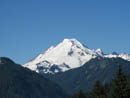
Mt. Baker |
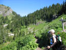
Trial Junction |
Meadow |
Mt. Shuksan |
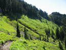
Shades Of Green |
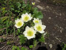
Anemone |
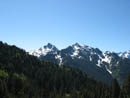
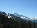
Goat Mountain |
Goat & Shuksan |
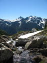
Creek |
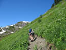
Grassy Slope |
Photo Page 2
Trips - 2006
Home