2-17-07
Last week we climbed up the ridge of Jim Hill Mountain
and saw little through the clouds. This week we returned to the area for
a winter scramble of Arrowhead Mountain. I scrambled up it in
2003
via the west side with a Mountaineer group. It was a great trip
and I had planned on a return trip at some point. Our group grew by the
day and by the end of the week it reached a dozen people and three dogs.
We met at the Stevens Pass Nordic Center at 8:45. I met Geo Tom, Opus (David),
and two of Opus's friends for the first time. We consolidated into fewer
cars and headed on.
In 2003 we drove a mile to the railroad tunnel facility where there is a large area plowed out along the highway. This time the lot had signs stating "Authorized Parking Only - Violators Will Be Towed". So much for that parking. Rick knew of a different spot a little farther east that is plowed. We headed on and that spot had one car and barely enough room for our four. Rather than the west route I knew we now changed our plan to the northeast ridge route.
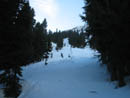
The group in the other car left just ahead of us. They had not done Arrowhead before. We crossed the road and walked a short way west. Snowshoes went on immediately. A short walk brought us to the railroad tracks. We headed east along the side the tracks. We left the tracks far too early heading up the slope. When we reached the powerline corridor it became clear that a rising traverse left would soon reach slopes too steep for comfort. We chose to descend the corridor back to the railroad grade. I hoped that the turns in the tracks would help us decide where to turn uphill. Unfortunately the tracks were perfectly straight on the map.
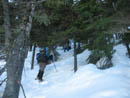
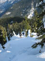
We chose to head uphill on a rising traverse towards the ridge to our left. We found the forest to be hard to get through though an open swath straight up was easy going. This swath narrowed to a snow filled gully and we could then hear a creek rushing below the snow. We exited the gully to the left and the route continued on the nose of a minor ridge. We could have easily traversed left towards the ridge but instead continued up a steepening slope. The snow was good and we made slow but steady progress.
We started at about 2760', climbed up to the railroad, then gently descended it to about 2700' where we left the grade. Previous reports mentioned reaching the NE Ridge between 4200' and 4800'. By the time we reached 4500' it was clear we were still nowhere near the ridge. The slope was now so steep that a long leftward traverse would be very difficult. We were locked into straight up or turn back.
Our minor ridge ended in a big open slope. Higher it narrowed down to a steep slot ending below cliffs on the ridge top. It appeared that at the top of the slot there might be a leftward route up onto the ridge. The slope was littered with the remnants of previous avalanches. The conditions seemed very stable. In fact, the snow here was suddenly rock hard. Several members did not have ice axes and only a few of us had crampons. Several folks started up the open slope but others of us were not in favor. That route went from snow scramble to a more serious climb.
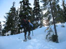
We huddled and decided that it might be possible to traverse up and to the left in the trees. It was steep but back on snow instead of the ice on the open slope. We climbed a short way and came to a very steep step. Only about 25' high but steep. It was at this point that several members reached and exceeded their comfort levels. David decided to lead them back down the mountain. The rest of us continued higher.
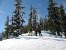
We all had out ice axes now. After the step the route weaved left then right to a nearly level spot. We had some pretty good views across the valley from here. I was really hoping that we could reach the ridge as descending that seemed far better than what we had just climbed. Bob, Kolleen, and Suzanne, were out front on this section and did a fine job of route finding. We could now see the ridge and the terrain was gentle enough to allow a near level traverse towards it. As we traversed small trees became a problem and the path of least resistance was again straight up. The snow was soft here and with the steepness it was very difficult to get steps to hold. We did better with the lighter women going first as Bob and I just sank and slid right back down again.
After more than a few hours of grinding uphill we finally reached the ridge. At 5500' we were now only 500' below the 6030' summit. It was already 1:30 and most of us were starving. We had only taken one short food break on the whole 2800' climb from the railroad tracks. The ridge crest is forested but we had little problem weaving around the trees. Part way up the ridge I was in front when I saw snowshoe prints merging into my route. It had to be the other group we saw at the start. The prints were only heading up so they had to be on top.
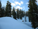
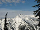
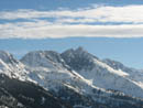
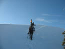
Along the ridge we had views to the north and later to the south. The weather was coming in but it was still mostly clear above us. We finally reached the summit and beautiful 360 degree views of the Central Cascades. From Mt. Daniel to Glacier Peak and many peaks in between. Even the wind was gentle on top. The other group was probably not thrilled to see nine others arrive but I was very glad to be there. They had been there some time and stayed a while longer. They did head down about 15 minutes before us.
I would love to have been able to stay longer but at 2:45 we packed up for our descent. The other group had no difficulty on the ridge coming up. We now had their prints to follow down. Rick carried his skis all the way up and now was ready to ski down. He could have descended in about one tenth the time we took but chose to keep us in sight. The ridge is forested but has some very good open views in places. It is mostly gentle, especially compared to what we came up. Somewhere near 4400' the tracks left the ridge and headed down the slope.
I was expecting some steep sections but it was pretty moderate all the way down. It was steep enough to make snowshoeing hard work. Most of us chose to take oft our snowshoes below the ridge. Probably not a good idea. The week before on Jim Hill we were able to easily plunge step down. Now the snow was softening to the point where we postholed deeply on every other step. We made steady progress down. With firmer snow I would have been down in half the time.
We were pretty beat when we reached the railroad tracks. The final mile or so was at a gentle uphill grade. We gained about 200' along there. I think we were all operating on fumes when we dropped down from the tracks to the highway. It turned out to be much more of an adventure than I was expecting. Even near the ridge I was not sure our route would go. In fact it worked out just fine. We took about 4 1/2 hours to summit and a little over 2 hours to descend. All that for maybe 6 miles round trip. If was a good day out with old friends and a chance to meet some new friends. The weather was about perfect for mid February. Now I have seen most all sides of the mountain. I'm sure I'll be back in a few years.
Here is another trip report with photos: Suzanne's Report
Click on thumbnails to get larger pictures.
Photo Page 2
Trips - 2007
Home
In 2003 we drove a mile to the railroad tunnel facility where there is a large area plowed out along the highway. This time the lot had signs stating "Authorized Parking Only - Violators Will Be Towed". So much for that parking. Rick knew of a different spot a little farther east that is plowed. We headed on and that spot had one car and barely enough room for our four. Rather than the west route I knew we now changed our plan to the northeast ridge route.
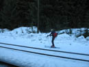
The group in the other car left just ahead of us. They had not done Arrowhead before. We crossed the road and walked a short way west. Snowshoes went on immediately. A short walk brought us to the railroad tracks. We headed east along the side the tracks. We left the tracks far too early heading up the slope. When we reached the powerline corridor it became clear that a rising traverse left would soon reach slopes too steep for comfort. We chose to descend the corridor back to the railroad grade. I hoped that the turns in the tracks would help us decide where to turn uphill. Unfortunately the tracks were perfectly straight on the map.
We chose to head uphill on a rising traverse towards the ridge to our left. We found the forest to be hard to get through though an open swath straight up was easy going. This swath narrowed to a snow filled gully and we could then hear a creek rushing below the snow. We exited the gully to the left and the route continued on the nose of a minor ridge. We could have easily traversed left towards the ridge but instead continued up a steepening slope. The snow was good and we made slow but steady progress.
We started at about 2760', climbed up to the railroad, then gently descended it to about 2700' where we left the grade. Previous reports mentioned reaching the NE Ridge between 4200' and 4800'. By the time we reached 4500' it was clear we were still nowhere near the ridge. The slope was now so steep that a long leftward traverse would be very difficult. We were locked into straight up or turn back.
Our minor ridge ended in a big open slope. Higher it narrowed down to a steep slot ending below cliffs on the ridge top. It appeared that at the top of the slot there might be a leftward route up onto the ridge. The slope was littered with the remnants of previous avalanches. The conditions seemed very stable. In fact, the snow here was suddenly rock hard. Several members did not have ice axes and only a few of us had crampons. Several folks started up the open slope but others of us were not in favor. That route went from snow scramble to a more serious climb.
We huddled and decided that it might be possible to traverse up and to the left in the trees. It was steep but back on snow instead of the ice on the open slope. We climbed a short way and came to a very steep step. Only about 25' high but steep. It was at this point that several members reached and exceeded their comfort levels. David decided to lead them back down the mountain. The rest of us continued higher.
We all had out ice axes now. After the step the route weaved left then right to a nearly level spot. We had some pretty good views across the valley from here. I was really hoping that we could reach the ridge as descending that seemed far better than what we had just climbed. Bob, Kolleen, and Suzanne, were out front on this section and did a fine job of route finding. We could now see the ridge and the terrain was gentle enough to allow a near level traverse towards it. As we traversed small trees became a problem and the path of least resistance was again straight up. The snow was soft here and with the steepness it was very difficult to get steps to hold. We did better with the lighter women going first as Bob and I just sank and slid right back down again.
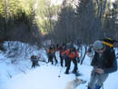
After more than a few hours of grinding uphill we finally reached the ridge. At 5500' we were now only 500' below the 6030' summit. It was already 1:30 and most of us were starving. We had only taken one short food break on the whole 2800' climb from the railroad tracks. The ridge crest is forested but we had little problem weaving around the trees. Part way up the ridge I was in front when I saw snowshoe prints merging into my route. It had to be the other group we saw at the start. The prints were only heading up so they had to be on top.
Along the ridge we had views to the north and later to the south. The weather was coming in but it was still mostly clear above us. We finally reached the summit and beautiful 360 degree views of the Central Cascades. From Mt. Daniel to Glacier Peak and many peaks in between. Even the wind was gentle on top. The other group was probably not thrilled to see nine others arrive but I was very glad to be there. They had been there some time and stayed a while longer. They did head down about 15 minutes before us.
I would love to have been able to stay longer but at 2:45 we packed up for our descent. The other group had no difficulty on the ridge coming up. We now had their prints to follow down. Rick carried his skis all the way up and now was ready to ski down. He could have descended in about one tenth the time we took but chose to keep us in sight. The ridge is forested but has some very good open views in places. It is mostly gentle, especially compared to what we came up. Somewhere near 4400' the tracks left the ridge and headed down the slope.
I was expecting some steep sections but it was pretty moderate all the way down. It was steep enough to make snowshoeing hard work. Most of us chose to take oft our snowshoes below the ridge. Probably not a good idea. The week before on Jim Hill we were able to easily plunge step down. Now the snow was softening to the point where we postholed deeply on every other step. We made steady progress down. With firmer snow I would have been down in half the time.
We were pretty beat when we reached the railroad tracks. The final mile or so was at a gentle uphill grade. We gained about 200' along there. I think we were all operating on fumes when we dropped down from the tracks to the highway. It turned out to be much more of an adventure than I was expecting. Even near the ridge I was not sure our route would go. In fact it worked out just fine. We took about 4 1/2 hours to summit and a little over 2 hours to descend. All that for maybe 6 miles round trip. If was a good day out with old friends and a chance to meet some new friends. The weather was about perfect for mid February. Now I have seen most all sides of the mountain. I'm sure I'll be back in a few years.
Here is another trip report with photos: Suzanne's Report

Start Along Highway |
Rick On Skis |
View North |
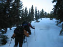
Above RR Tracks |
Steady Grind |
Icy Open Slope |
More Steeps |
Ridge At Last |
Ridge Break |
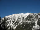
Rock Mountain |
Look Down Ridge |
View East |
Summit In Sight |
A Few Feet More |
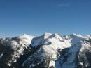
Chiwaukum Mtns |
Photo Page 2
Trips - 2007
Home