8/18-20/08
Since my brother moved to Sun Valley I have made a
late summer pilgrimage to visit and to hike and backpack this terrific
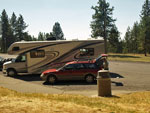
area. This was my fourth trip. This time Kim accompanied me and we drove.
I flew in on the three earlier visits. It's a long day of driving but not
so bad with two people trading off. We headed out at 6:30 am on Saturday
and arrived 680 miles later and one time zone change at 6:45 pm MDT in Sun
Valley. My house is at 220' above sea level and my brother's is at 5800'.
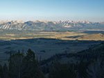
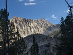
The Sawtooth and White Cloud Mountains soar much higher. We spent Sunday
just getting a little acclimatized.
Since Kim had never hiked in Idaho I planned another grand tour of the Sawtooths. Turns out a fire broke out the day before and half the route was closed and being evacuated. Time for a change of plans. A quick scan of reports on the Internet led to a backup idea. It required an extra 60 miles driving each way but looked really good. We set out early on Monday morning heading north over Galena Summit and into the Salmon River Valley.
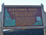
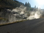
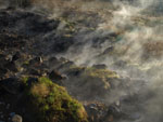
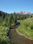
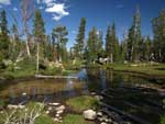
We stopped at the Stanley Ranger Station for last minute fire info and discovered the Sawtooth fire was out and the route was open. After a quick huddle we chose to use our back up plan in the White Cloud Mountains. We drove east still on Highway 75 along the growing Salmon River. We stopped where smoke seemed to be coming from the hillside along the road. In fact, it was steam from Sunbean hot springs. The water was very hot. A family was down in a pool along the Salmon River where the hot water flowed.
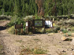
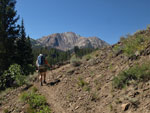
Back on route we reached the East Fork Salmon River Road and turned south. My old hiking book talked about 5 miles of pavement. Not any more. It is now paved for 15 miles with farms up the valley. Very craggy terrrain with sagebrush and views to the peaks above. One mile of dirt led to a turnoff and 4 1/2 more miles of dirt to the trailhead near Livingston Mill. This is one of the more popular trailheads in the White Clouds and even on a Monday morning there were 4 or 5 cars there. The trail starts at 7200' which is higher than most of the crest of the Cascade Mountains in Washington.
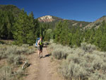
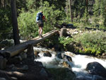
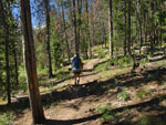
It was already warming at 9:30 am and we were soon in shorts and short sleeves. The trail soon crosses a crcek on a single log. Every crossing was bridged and nearly every one had two side by side logs. The first two miles are open to motorcycles. At that point the trail splits. Left goes up to Frog Lake and the Boulder Chain Lakes. Right immediately crosses the creek and heads up to Walker, Island, and Big Boulder Lakes.
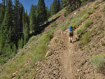
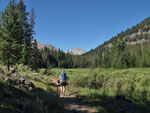
The route is never very steep. It climbs through forest and open fields of sagebrush dotted with flowers. We were a little surprised to see a lot of flowers in late August. We were passed by one group of day hikers heading up. A little later we met another couple coming down who backpacked to Walker Lake and the upper lakes. My books talked about crossing Quicksand Meadow. We reached a sign for a descent to the meadow but the main trail now continues on a traverse above the meadow and creek. This trail looked to be very new.
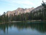
With the elevation and heat we were wilting on the trail. A little cool breeze really helped. Where the new and old trails met the route was again near the creek in a more sub alpine area. Big granite rocks dotted the ground with grass and smaller trees. we soon reached the intersecton. Straight ahead a mile to Island Lake or right to Walker. After a break we headed on to Walker. The trail is steeper and rockier here but soon we were cresting a ridge and entering the basin. We wandered quite a way through meadows and along the outlet stream before reaching the lake.
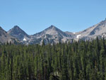
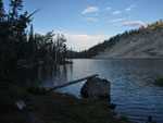
Walker Lake sits at the end of a forested basin at 9239'. We were almost as high as Mt. Stuart in the Cascades but still in forest. Quite a change from what we are used to. The earlier backpacking couple we met suggested the campsite at the far end of the lake. We were about out of gas as we hiked past several nice sites along the lake. We chose a big site near the inlet stream. A little later another group came in and continued past the inlet to a nice site across the lake from us. We set up the tent, hung our food, had dinner, and were ready to call it a day. For the day we hiked about 8 miles with 2200' of gain.
Click on thumbnails to get larger pictures.
Photo Page 2
Trips - 2008
Home
Since Kim had never hiked in Idaho I planned another grand tour of the Sawtooths. Turns out a fire broke out the day before and half the route was closed and being evacuated. Time for a change of plans. A quick scan of reports on the Internet led to a backup idea. It required an extra 60 miles driving each way but looked really good. We set out early on Monday morning heading north over Galena Summit and into the Salmon River Valley.
We stopped at the Stanley Ranger Station for last minute fire info and discovered the Sawtooth fire was out and the route was open. After a quick huddle we chose to use our back up plan in the White Cloud Mountains. We drove east still on Highway 75 along the growing Salmon River. We stopped where smoke seemed to be coming from the hillside along the road. In fact, it was steam from Sunbean hot springs. The water was very hot. A family was down in a pool along the Salmon River where the hot water flowed.
Back on route we reached the East Fork Salmon River Road and turned south. My old hiking book talked about 5 miles of pavement. Not any more. It is now paved for 15 miles with farms up the valley. Very craggy terrrain with sagebrush and views to the peaks above. One mile of dirt led to a turnoff and 4 1/2 more miles of dirt to the trailhead near Livingston Mill. This is one of the more popular trailheads in the White Clouds and even on a Monday morning there were 4 or 5 cars there. The trail starts at 7200' which is higher than most of the crest of the Cascade Mountains in Washington.
It was already warming at 9:30 am and we were soon in shorts and short sleeves. The trail soon crosses a crcek on a single log. Every crossing was bridged and nearly every one had two side by side logs. The first two miles are open to motorcycles. At that point the trail splits. Left goes up to Frog Lake and the Boulder Chain Lakes. Right immediately crosses the creek and heads up to Walker, Island, and Big Boulder Lakes.
The route is never very steep. It climbs through forest and open fields of sagebrush dotted with flowers. We were a little surprised to see a lot of flowers in late August. We were passed by one group of day hikers heading up. A little later we met another couple coming down who backpacked to Walker Lake and the upper lakes. My books talked about crossing Quicksand Meadow. We reached a sign for a descent to the meadow but the main trail now continues on a traverse above the meadow and creek. This trail looked to be very new.
With the elevation and heat we were wilting on the trail. A little cool breeze really helped. Where the new and old trails met the route was again near the creek in a more sub alpine area. Big granite rocks dotted the ground with grass and smaller trees. we soon reached the intersecton. Straight ahead a mile to Island Lake or right to Walker. After a break we headed on to Walker. The trail is steeper and rockier here but soon we were cresting a ridge and entering the basin. We wandered quite a way through meadows and along the outlet stream before reaching the lake.
Walker Lake sits at the end of a forested basin at 9239'. We were almost as high as Mt. Stuart in the Cascades but still in forest. Quite a change from what we are used to. The earlier backpacking couple we met suggested the campsite at the far end of the lake. We were about out of gas as we hiked past several nice sites along the lake. We chose a big site near the inlet stream. A little later another group came in and continued past the inlet to a nice site across the lake from us. We set up the tent, hung our food, had dinner, and were ready to call it a day. For the day we hiked about 8 miles with 2200' of gain.
Itty Bitty Outback |
Historical Marker |
Salmon Rvr & Sawtooths |
Road Side Steam |
Sunbeam Hot Springs |
Livingston Mill Trailhead |
Start Of Trail |
Grassy Slope |
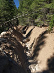
New Ravine |
Big Boulder Creek |
Peak Beyond Meadow |
Creek Crossing |
Closer To Peaks |
Cooling Shade |
Improving Peak Views |
Waterfall |
Granite Peaks |
Outlet Creek Meadow |
Walker Lake |
Setting Sun On Lake |
Photo Page 2
Trips - 2008
Home