8/2-3/08
It's the beginning of August and Gary and I had only
been out hiking together one time this year. With us both free for the
weekend we though of destinations for an overnight backpacking trip. We
were hoping for clear skies and so chose to go east of the crest. A little
discussion and we settled on a trip neither one of us had done. Bismarck
Peak is just south of Mt. Aix along Nelson Ridge. At 7585' it is a little
lower than Aix but still high enough to provide a great vantage point.
I met Gary at his house at 7:00 am. We headed out on highway 410 crossing Chinook Pass. We headed up the Bumping River Road and on to the gravel section. It is in better shape than I have often seen it though still rough. We passed the Mt. Aix trailhead where there was one car. A few hundred feet later we crossed the bridge and found the Bismarck parking lot. The road is closed at this point due to washouts. It's another 4 1/2 miles of walking to reach the Twin Sisters Lakes trailhead. There was a horse group camped near the trailhead. We were on the trail at about 9:40 am.
Our route would start on the Pear Butte Trail then branch off on the Bismarck Trail to a meadow below the peak where we would camp. We planned to summit Sunday morning and then retrace our steps. We could find only 4 reports on this route online so our info was limited. We did know the Bismarck Trail does not get much maintenance and is a little sketchy. The trailhead is at about 3650' and the final meadow is at 6300'. Figure on another 1000' of up and down gains.
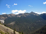
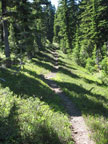
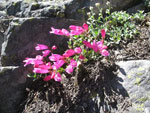
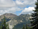
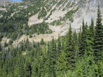
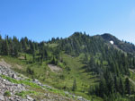
The trail begins easily gaining elevation gently though forest. After several miles it begins to switchback uphill. The switchbacks end at about 5200' when the ridge crest is attained. That is about it for switchbacks. This trail follows on or just below ridge crests all the rest of the way to Bismarck. We began to see flowers on the ridge. This is not a great flower show hike but we did see a good variety. Once on the ridge we also began to get occasional views to Mt. Rainier. We could see clouds to the west though we were mostly under clear skies.
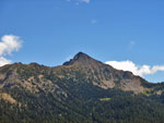
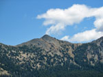
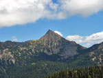
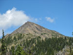
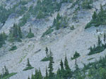
Bismarck Peak came into view early and we saw it from different angles as we continued down the trail. We could see the edge of our destination meadow and it looked to be along way away from where we had our first view. The ridge undulates up and down though no single drop and climb is very large. At noon we started looking for a lunch spot and by 12:15 we found one. We had nice views out to Bismarck Peak and a little breeze to keep us cool under the warm sun.
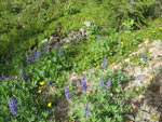
We took a full hour to eat, enjoy the views, and consult our maps. The few reports we read did mention discrepancies in the maps and the trail on the ground. One map even showed a switchbacking trail to the summit. No reports suggested such a trail exists. After lunch we headed along the ridge. Much of the ridge is near 6000' so we were not far in elevation from our destination for the day. In places the ridge top was a flat meadow with wildflowers.
At one point near the 4 mile point the trail dropped down to a long narrow meadow where the trail disappears. It could go on straight ahead or possibly head left. We scouted around to the left and found tread taking off perpendicular to the direction we had been heading. This is completely unmarked. Tread was soon back to easily followed. We knew we were getting close to the Bismarck junction and kept a lookout to our left. Obviously not good enough.
As we began to descend we were worried that we may have gone too far. The trail was in forest here and we could not see out to the ridge we needed. We stepped through the trees and confirmed that our ridge was now behind us. Oh well, time to head back uphill. We soon found the well signed turn. Well signed that is if you are going north. There are signs on a tree that are not visible while heading south. The Bismarck trail also switches back downhill when heading south. It is very hard to see.
Now on the correct route we descended to a saddle and a four way intersection. Huh? Why an intersection when the map shows the trail heading straight ahead on the ridge top? The main route seemed to go off to the left. Gary followed it a ways and it then split. Neither seemed to be a main route to him. We headed out on the right side of the ridge crest on obvious though minimal tread. This part was a bit sketchy as it traversed loose rock and bare ground. At one point near the ridge crest we headed up and looked at the other side. It had real tread.
The answer became clear on our way back. The trail starts on the right side and crosses the ridge several times. The left side sections are nice tread. The right side are loose and crummy. We blocked off a few boot paths to better show where the ridge crossings are. Bottom line is that the correct route is not that bad though a little difficult to follow in a few places. From the saddle we were slowly ascending as the ridge climbed. Near the high point the trail went onto the left side and stayed there. Now it was much easier travel.
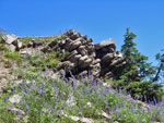
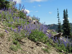
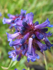
The route descended 375' to another saddle before climbing once again. We saw one small snow patch near the trail and that was it for the weekend except for some snow tucked under Bismarck Peak and a big patch off trail in a meadow just before the final meadow. There are a dozen or so trees down across the Bismarck Trail but we could step across every one of them. Hardly worth mentioning. We did find some large fields of lupine on this part of the ridge.
A few more ups and downs brought us to a saddle before Point 6816. The map shows the trail going around the right side. One report mentioned going right over the top. Another mentioned the route going around the left side though disappearing in places. This report was nine years old. We found a junction. Two very obvious trails with one going around the left side and one heading up towards the crest. I would guess the second one goes over the top. Looking down from the summit there is no route around the right side.
The left side trail began very nicely in forest. Another trail with good tread headed lower. We continued ahead. The trail traverses Point 6816 with a slight uphill grade. When forest gave way to open slopes the tread became almost indistinguishable. The route began to look like an animal trail. Although the slope is moderately steep we did have enough footing to feel comfortable. Farther along there was a section in trees and very obvious tread was reached. It's sketchy but if paying attention it's not that hard to stay on track. We reached a gentle rib and the trail, now with nice tread began to descend towards the meadow below.
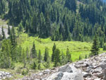
We passed the one smaller meadow with the snow bank then dropped into the main meadow. It is very lush and green. It is sloping so our next job was to find a level camp site. One other fact about this remarkable weekend. We had no bugs at the trailhead, none along the ridge, and none in this wet meadow. Amazing to say the least. We failed to find a good site and headed uphill. Nope, no sites up there. We saw a bench to the north and scrambled up some rocks to find a small meadow with some flat ground and a rocky wind break. A perfect camp spot.
We set up camp and hung our food. We had to drop several hundred feet from camp to the meadow and down lower to find a spot on the creek with a good flow of running water. With all chores done we settled in for dinner. Our kitchen was on the top of the rocks surrounding our camp spot. Gary noticed a blaze on a tree. In fact there were three blazes on different trees there. Why were they up here? We looked closely and found an old trail went right through our kitchen. Though covered in rocks a trail descended to the lower meadow. That trail is now clear once again.
After dinner we set out to try to find where the trail continued on to. There was no sign in the upper meadow so we headed on into open forest to search. We headed down then up slope hoping to find tread once again. We found many animal trails and some that looked like tread though they all petered out quickly. We were shocked to find four logs in a square. There was another layer on several sides. It was the remains of a 6' x 6' building. What was it doing up here so far from the trail in the main meadow? It remains a mystery. We added another clue when we reached the summit.
Clouds began to blow in and the top of Nelson Ridge right above us was in and out of the clouds. We went to bed at 9:15 and the thermometer read 41 degrees. I think we reached the mid 30s over night.
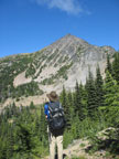
Day two began with clear skies. We were up by 6:00 am and on our way by 7:05. We headed across the upper meadow and followed bootpaths most of the way to the saddle between Point 6816 and Bismarck Peak. Our only information was that you could go left or right from the saddle but right was likely easier. Some loose rock but no real problems. At the saddle we had our first up close view of the southwest ridge of Bismarck. Left looked like loose rock climbing to a narrow gully and no way to see what was above. Right was a big rocky fin that I could not climb. Straight ahead just right of the crest was scrubby trees that took you up a few hundred feet then no way to see what was above. Not the easy though loose slope I expected to see.
We also saw a very obvious animal (maybe hiker) trail descending under the fin at far right. It was on an open dirt slope and looked easy enough to follow. After a short debate we chose to follow around right and see if the terrain looked better around there. We made it around the rocky rib and found the route continued to make a long level traverse. Going up here did not look like much fun so on we went. Though sketchy while crossing a few gullies the route continued on.
We reached a band of trees and the terrain above now looked pretty good. We chose to head straight up. The trees soon ended and we were on talus, scree, and heather. Really loose in places and not bad at all in others. We reached the pass at about 6600' and after traversing we were at 6400' It was too steep to see the real summit so we just kept going up hoping the route would go. The grade became gentler then much steeper. I looked down debating how much I wanted to descend a 40 degree slope of deep loose gravel and talus.
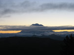
We could soon see a ridge just above us. We made an uphill traverse left on loose talus to the ridge. From there things improved markedly. We could see out to Mt. Rainier and Mt. Aix as well as all along the length of Nelson Ridge. The ridge up was steep but on mostly good rock. It was much easier than what we had done. There were no more impediments as we soon were on the summit. It was only 8:40 and the lighting was excellent. We had a great panorama from Mt. Adams to the Goat Rocks to Mt. Rainier on to the peaks of the Cascade crest north of Snoqualmie Pass to Mt. Stuart. Mt. Aix is just a few miles away. Nelson ridge connects the two peaks and some of the reports were for both peaks and a 2 1/2 mile ridge walk. It looked sketchy in places but much better when magnified. We could see our tent and another meadow farther below. That meadow has a very distinct trail heading across it. I bet it is the continuation of the one that cut through our camp.
The peak seems to be getting more popular. A report mentioned about 3 visits per year signed the old register. The new one was placed in 2004 and had 3 visits that year. This year we were the 12th party to sign in. We spent a full 1:40 on the summit. I was just not in any hurry to leave. Only the 8 mile hike out and the 2 1/2 hour drive home had us moving. One report mentioned dropping several hundred feet and crossing under the summit of Bismarck to reach Nelson Ridge. It looked really bad when viewed from camp though not as bad close up. It is steep and loose but a confident scrambler could likely do it. From the meadow one could also easily climb to Nelson Ridge north of Bismarck.
We chose to follow our route down. With the loose rocks and dirt we were able to follow our footprints all the way down. We did chose to drop about 75' farther down the ridge before traversing onto the talus/scree to avoid the steepest spot. At no time could we see all of the ridge and I still do not know if one could go straight up from the pass while it remained just a scramble. Our route may have been longer and maybe even harder but it worked just fine.
We made it to camp by 11:40. By the time we were on the trail it was 12:40. We made much better time coming out as we took less photo stops. The 1000' of uphill on the way out seemed like 2500'. It was warm and sunny for the first half with most of the gain. Later some clouds came in and I was very happy with the cooling. We came down in 3 1/2 hours.
This was a fantastic weekend. We expected to see nobody and that was the case. Bugs were not a problem. We found a great campsite and plentiful water. We scouted an old blazed trail and found a building carcass. The scramble was fun with some route finding problems but not death defying. We even had some flowers to go along with amazing views. Sometimes it pays to go where others don't.
Click on thumbnails to get larger pictures.
Photo Page 2
Trips - 2008
Home
I met Gary at his house at 7:00 am. We headed out on highway 410 crossing Chinook Pass. We headed up the Bumping River Road and on to the gravel section. It is in better shape than I have often seen it though still rough. We passed the Mt. Aix trailhead where there was one car. A few hundred feet later we crossed the bridge and found the Bismarck parking lot. The road is closed at this point due to washouts. It's another 4 1/2 miles of walking to reach the Twin Sisters Lakes trailhead. There was a horse group camped near the trailhead. We were on the trail at about 9:40 am.
Our route would start on the Pear Butte Trail then branch off on the Bismarck Trail to a meadow below the peak where we would camp. We planned to summit Sunday morning and then retrace our steps. We could find only 4 reports on this route online so our info was limited. We did know the Bismarck Trail does not get much maintenance and is a little sketchy. The trailhead is at about 3650' and the final meadow is at 6300'. Figure on another 1000' of up and down gains.
The trail begins easily gaining elevation gently though forest. After several miles it begins to switchback uphill. The switchbacks end at about 5200' when the ridge crest is attained. That is about it for switchbacks. This trail follows on or just below ridge crests all the rest of the way to Bismarck. We began to see flowers on the ridge. This is not a great flower show hike but we did see a good variety. Once on the ridge we also began to get occasional views to Mt. Rainier. We could see clouds to the west though we were mostly under clear skies.
Bismarck Peak came into view early and we saw it from different angles as we continued down the trail. We could see the edge of our destination meadow and it looked to be along way away from where we had our first view. The ridge undulates up and down though no single drop and climb is very large. At noon we started looking for a lunch spot and by 12:15 we found one. We had nice views out to Bismarck Peak and a little breeze to keep us cool under the warm sun.
We took a full hour to eat, enjoy the views, and consult our maps. The few reports we read did mention discrepancies in the maps and the trail on the ground. One map even showed a switchbacking trail to the summit. No reports suggested such a trail exists. After lunch we headed along the ridge. Much of the ridge is near 6000' so we were not far in elevation from our destination for the day. In places the ridge top was a flat meadow with wildflowers.
At one point near the 4 mile point the trail dropped down to a long narrow meadow where the trail disappears. It could go on straight ahead or possibly head left. We scouted around to the left and found tread taking off perpendicular to the direction we had been heading. This is completely unmarked. Tread was soon back to easily followed. We knew we were getting close to the Bismarck junction and kept a lookout to our left. Obviously not good enough.
As we began to descend we were worried that we may have gone too far. The trail was in forest here and we could not see out to the ridge we needed. We stepped through the trees and confirmed that our ridge was now behind us. Oh well, time to head back uphill. We soon found the well signed turn. Well signed that is if you are going north. There are signs on a tree that are not visible while heading south. The Bismarck trail also switches back downhill when heading south. It is very hard to see.
Now on the correct route we descended to a saddle and a four way intersection. Huh? Why an intersection when the map shows the trail heading straight ahead on the ridge top? The main route seemed to go off to the left. Gary followed it a ways and it then split. Neither seemed to be a main route to him. We headed out on the right side of the ridge crest on obvious though minimal tread. This part was a bit sketchy as it traversed loose rock and bare ground. At one point near the ridge crest we headed up and looked at the other side. It had real tread.
The answer became clear on our way back. The trail starts on the right side and crosses the ridge several times. The left side sections are nice tread. The right side are loose and crummy. We blocked off a few boot paths to better show where the ridge crossings are. Bottom line is that the correct route is not that bad though a little difficult to follow in a few places. From the saddle we were slowly ascending as the ridge climbed. Near the high point the trail went onto the left side and stayed there. Now it was much easier travel.
The route descended 375' to another saddle before climbing once again. We saw one small snow patch near the trail and that was it for the weekend except for some snow tucked under Bismarck Peak and a big patch off trail in a meadow just before the final meadow. There are a dozen or so trees down across the Bismarck Trail but we could step across every one of them. Hardly worth mentioning. We did find some large fields of lupine on this part of the ridge.
A few more ups and downs brought us to a saddle before Point 6816. The map shows the trail going around the right side. One report mentioned going right over the top. Another mentioned the route going around the left side though disappearing in places. This report was nine years old. We found a junction. Two very obvious trails with one going around the left side and one heading up towards the crest. I would guess the second one goes over the top. Looking down from the summit there is no route around the right side.
The left side trail began very nicely in forest. Another trail with good tread headed lower. We continued ahead. The trail traverses Point 6816 with a slight uphill grade. When forest gave way to open slopes the tread became almost indistinguishable. The route began to look like an animal trail. Although the slope is moderately steep we did have enough footing to feel comfortable. Farther along there was a section in trees and very obvious tread was reached. It's sketchy but if paying attention it's not that hard to stay on track. We reached a gentle rib and the trail, now with nice tread began to descend towards the meadow below.
We passed the one smaller meadow with the snow bank then dropped into the main meadow. It is very lush and green. It is sloping so our next job was to find a level camp site. One other fact about this remarkable weekend. We had no bugs at the trailhead, none along the ridge, and none in this wet meadow. Amazing to say the least. We failed to find a good site and headed uphill. Nope, no sites up there. We saw a bench to the north and scrambled up some rocks to find a small meadow with some flat ground and a rocky wind break. A perfect camp spot.
We set up camp and hung our food. We had to drop several hundred feet from camp to the meadow and down lower to find a spot on the creek with a good flow of running water. With all chores done we settled in for dinner. Our kitchen was on the top of the rocks surrounding our camp spot. Gary noticed a blaze on a tree. In fact there were three blazes on different trees there. Why were they up here? We looked closely and found an old trail went right through our kitchen. Though covered in rocks a trail descended to the lower meadow. That trail is now clear once again.
After dinner we set out to try to find where the trail continued on to. There was no sign in the upper meadow so we headed on into open forest to search. We headed down then up slope hoping to find tread once again. We found many animal trails and some that looked like tread though they all petered out quickly. We were shocked to find four logs in a square. There was another layer on several sides. It was the remains of a 6' x 6' building. What was it doing up here so far from the trail in the main meadow? It remains a mystery. We added another clue when we reached the summit.
Clouds began to blow in and the top of Nelson Ridge right above us was in and out of the clouds. We went to bed at 9:15 and the thermometer read 41 degrees. I think we reached the mid 30s over night.
Day two began with clear skies. We were up by 6:00 am and on our way by 7:05. We headed across the upper meadow and followed bootpaths most of the way to the saddle between Point 6816 and Bismarck Peak. Our only information was that you could go left or right from the saddle but right was likely easier. Some loose rock but no real problems. At the saddle we had our first up close view of the southwest ridge of Bismarck. Left looked like loose rock climbing to a narrow gully and no way to see what was above. Right was a big rocky fin that I could not climb. Straight ahead just right of the crest was scrubby trees that took you up a few hundred feet then no way to see what was above. Not the easy though loose slope I expected to see.
We also saw a very obvious animal (maybe hiker) trail descending under the fin at far right. It was on an open dirt slope and looked easy enough to follow. After a short debate we chose to follow around right and see if the terrain looked better around there. We made it around the rocky rib and found the route continued to make a long level traverse. Going up here did not look like much fun so on we went. Though sketchy while crossing a few gullies the route continued on.
We reached a band of trees and the terrain above now looked pretty good. We chose to head straight up. The trees soon ended and we were on talus, scree, and heather. Really loose in places and not bad at all in others. We reached the pass at about 6600' and after traversing we were at 6400' It was too steep to see the real summit so we just kept going up hoping the route would go. The grade became gentler then much steeper. I looked down debating how much I wanted to descend a 40 degree slope of deep loose gravel and talus.
We could soon see a ridge just above us. We made an uphill traverse left on loose talus to the ridge. From there things improved markedly. We could see out to Mt. Rainier and Mt. Aix as well as all along the length of Nelson Ridge. The ridge up was steep but on mostly good rock. It was much easier than what we had done. There were no more impediments as we soon were on the summit. It was only 8:40 and the lighting was excellent. We had a great panorama from Mt. Adams to the Goat Rocks to Mt. Rainier on to the peaks of the Cascade crest north of Snoqualmie Pass to Mt. Stuart. Mt. Aix is just a few miles away. Nelson ridge connects the two peaks and some of the reports were for both peaks and a 2 1/2 mile ridge walk. It looked sketchy in places but much better when magnified. We could see our tent and another meadow farther below. That meadow has a very distinct trail heading across it. I bet it is the continuation of the one that cut through our camp.
The peak seems to be getting more popular. A report mentioned about 3 visits per year signed the old register. The new one was placed in 2004 and had 3 visits that year. This year we were the 12th party to sign in. We spent a full 1:40 on the summit. I was just not in any hurry to leave. Only the 8 mile hike out and the 2 1/2 hour drive home had us moving. One report mentioned dropping several hundred feet and crossing under the summit of Bismarck to reach Nelson Ridge. It looked really bad when viewed from camp though not as bad close up. It is steep and loose but a confident scrambler could likely do it. From the meadow one could also easily climb to Nelson Ridge north of Bismarck.
We chose to follow our route down. With the loose rocks and dirt we were able to follow our footprints all the way down. We did chose to drop about 75' farther down the ridge before traversing onto the talus/scree to avoid the steepest spot. At no time could we see all of the ridge and I still do not know if one could go straight up from the pass while it remained just a scramble. Our route may have been longer and maybe even harder but it worked just fine.
We made it to camp by 11:40. By the time we were on the trail it was 12:40. We made much better time coming out as we took less photo stops. The 1000' of uphill on the way out seemed like 2500'. It was warm and sunny for the first half with most of the gain. Later some clouds came in and I was very happy with the cooling. We came down in 3 1/2 hours.
This was a fantastic weekend. We expected to see nobody and that was the case. Bugs were not a problem. We found a great campsite and plentiful water. We scouted an old blazed trail and found a building carcass. The scramble was fun with some route finding problems but not death defying. We even had some flowers to go along with amazing views. Sometimes it pays to go where others don't.
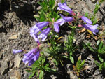
Purple Penstemon |
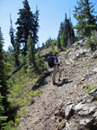
Nearing Ridge Top |
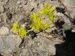
Yellow Flowers |
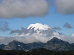
Clouds & Mt. Rainier |
Early Look At Bismarck |
Copper Creek Valley |
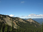
Point On Nelson Ridge |
Forest Meadow |
Bright Penstemon |
New Angle Of Bismarck |
Rocks & Lupine |
Peaking Lupine |
Glimpse Of Mt. Aix |
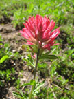
Red Paintbrush |
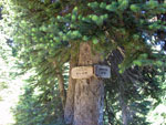
Signs We Missed |
Ridge We Ascended |
Scramble Route |
Gary & Bismarck |
Meadow Is Below |
Meadow From Camp |
Saddle & Point 6816 |
Creek & Flowers |
Flower Close Up |
Rainier At Sunset |
Goat Above Camp |
Photo Page 2
Trips - 2008
Home