1-06-08
High avalanche danger left us with few choices this
day. Bob, Kolleen, Suzanne, and I had done most of the safer winter trips
near Seattle in the previous month. We decided another trip up Dirty Harry's
peak was in order. Several years ago Bob, Kolleen, and I had slogged in
very deep snow to the summit to find high wind and no views. Last year Suzanne
and I made it about 3/4 of the way in 33 degree sleet. We were soaked and
the snow was getting deeper. It was the worst trip of the year by far. With
those fresh memories we set out to a day forecast to be overcast with some
light snow.
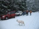
Before leaving we had to deal with falling snow at Suzanne's place on Queen Anne Hill in Seattle. Although it was snowing that low we did decide to give the trip a try. Suzanne and I met Bob and Kolleen plus Joanna and Mark at the gate to the road to the Fire Training Center. There was snow at Exit 38 and all the way to the gate. The gate was open but Bob said he had driven the .80 miles to the trailhead and there was nowhere to park. Snow plowing had made a berm along the road making parking very difficult. We met at 8:10 and were on our way by about 8:25. It was now snowing hard.
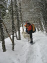
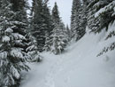
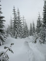
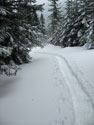
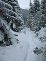
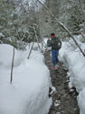
The road had been recently plowed but it had an inch or two of fresh snow. The first part of the trail is n old road bed that is more like a gravel creek bed in many spots. With a little snow on it it was actually easier to walk on. I always think the turn off to Dirty Harry's Balcony is just a short ways up. It isn't. As we ascended the snow became deeper. It was easier to boot it until just before the turn off. We were sinking in 6 -8 inches by then. With snowshoes on we continued. There is an opening in the forest and when we reached it there was some sun shining through.
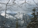
We could see MeClellan Butte and Mt. Washington across the valley. A little higher we reached the creek. It was here that another hiker caught up with us. After crossing the creek the route is a gravel creek bed. We banged out snowshoes on the rocks until we were back on snow. Just before the next switchback we stopped for a food and water break. Suzanne and the other hiker went ahead. I was not feeling very well so I too chose to head out ahead of the rest of the group. I hoped to get ahead and so not fall to far behind when the others got going.
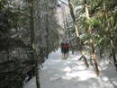
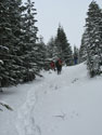
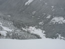
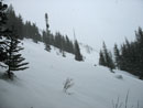
The next stretch is usually the toughest. Water runs down the road bed in many places and little or no snow collects. Our route went above on the sides at times and right down the rock middle when that was the only way. At the next switchback the road goes along the bottom of a big open slope. The open spot is only 100' or so long but is the only avalanche possible spot. The slope had no signs or sloughing and seemed well consolidated. Once across the route began to get steeper.
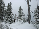
Steeper and deeper. Thankfully the two ahead were pounding out a nice trench. I kept up a slow but steady pace. Another switchback and Mark caught and passed me. I had no extra energy this day but was not that disappointed to have another trench maker ahead of me. Kolleen was the next to pass me. The group stopped and I finally caught up. They were discussing how much farther we had to go. My altimeter said about 350' to go. We were now only about a half mile from the top. In short order we ran out of mountain.
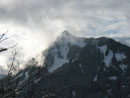
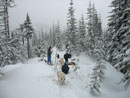
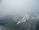
I was on top in 1986 and had a fine view. It was sunny and there were few trees there. In 2006 I summited again with clouds and no views. My third time was somewhere in between. It was cloudy but we could see down to the Granite Lakes and across towards the cabin and Revolution Peak. My cheap thermometer read 25 degrees and it felt at least that cold. As we approached the summit we passed the other hiker who was already heading down.
Suzanne was getting cold and she was next to head down. Bob and Kolleen were next and I followed. The first 1000' down took only 22 minutes. I was half walking and half skiing down our trench. I took my big 30" snowshoes and wished I had something shorter for the descent. I was tripping over myself trying to go fast. Heck, I was tripping over myself going slow.
We had one more stop just below the open slope. I caught up with Bob and Kolleen and Mark and Joanna caught up with us. We were making good time and soon were back on the move. There was one more stop just across Museum Creek and I chose to blast ahead. I was finally feeling better. I kept snowshoes on well past where we first put them on. When I reached a big dirt patch they came off.
As I reached the bottom I was only a little surprised to see Suzanne's car. She came down, walked the .80 miles back to the car and then drove back to wait for us. We took about 3:15 going up and Suzanne came down in about 1:30. It was again snowing very hard at the bottom. This forecast was bad but the trip was a lot of fun. With the extra road walk it was about 12 miles for me with 3500' of gain. We avoided areas of high avalanche danger and managed ot get away from the Tiger, Rattlesnake, Si hikes we have done plenty of recently. Best of all it made up for the worst trip of last year - Dirty Harry's Peak.
Click on thumbnails to get larger pictures.
Trips - 2008
Home
Before leaving we had to deal with falling snow at Suzanne's place on Queen Anne Hill in Seattle. Although it was snowing that low we did decide to give the trip a try. Suzanne and I met Bob and Kolleen plus Joanna and Mark at the gate to the road to the Fire Training Center. There was snow at Exit 38 and all the way to the gate. The gate was open but Bob said he had driven the .80 miles to the trailhead and there was nowhere to park. Snow plowing had made a berm along the road making parking very difficult. We met at 8:10 and were on our way by about 8:25. It was now snowing hard.
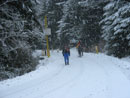
The road had been recently plowed but it had an inch or two of fresh snow. The first part of the trail is n old road bed that is more like a gravel creek bed in many spots. With a little snow on it it was actually easier to walk on. I always think the turn off to Dirty Harry's Balcony is just a short ways up. It isn't. As we ascended the snow became deeper. It was easier to boot it until just before the turn off. We were sinking in 6 -8 inches by then. With snowshoes on we continued. There is an opening in the forest and when we reached it there was some sun shining through.
We could see MeClellan Butte and Mt. Washington across the valley. A little higher we reached the creek. It was here that another hiker caught up with us. After crossing the creek the route is a gravel creek bed. We banged out snowshoes on the rocks until we were back on snow. Just before the next switchback we stopped for a food and water break. Suzanne and the other hiker went ahead. I was not feeling very well so I too chose to head out ahead of the rest of the group. I hoped to get ahead and so not fall to far behind when the others got going.
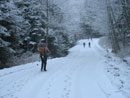
The next stretch is usually the toughest. Water runs down the road bed in many places and little or no snow collects. Our route went above on the sides at times and right down the rock middle when that was the only way. At the next switchback the road goes along the bottom of a big open slope. The open spot is only 100' or so long but is the only avalanche possible spot. The slope had no signs or sloughing and seemed well consolidated. Once across the route began to get steeper.
Steeper and deeper. Thankfully the two ahead were pounding out a nice trench. I kept up a slow but steady pace. Another switchback and Mark caught and passed me. I had no extra energy this day but was not that disappointed to have another trench maker ahead of me. Kolleen was the next to pass me. The group stopped and I finally caught up. They were discussing how much farther we had to go. My altimeter said about 350' to go. We were now only about a half mile from the top. In short order we ran out of mountain.
I was on top in 1986 and had a fine view. It was sunny and there were few trees there. In 2006 I summited again with clouds and no views. My third time was somewhere in between. It was cloudy but we could see down to the Granite Lakes and across towards the cabin and Revolution Peak. My cheap thermometer read 25 degrees and it felt at least that cold. As we approached the summit we passed the other hiker who was already heading down.
Suzanne was getting cold and she was next to head down. Bob and Kolleen were next and I followed. The first 1000' down took only 22 minutes. I was half walking and half skiing down our trench. I took my big 30" snowshoes and wished I had something shorter for the descent. I was tripping over myself trying to go fast. Heck, I was tripping over myself going slow.
We had one more stop just below the open slope. I caught up with Bob and Kolleen and Mark and Joanna caught up with us. We were making good time and soon were back on the move. There was one more stop just across Museum Creek and I chose to blast ahead. I was finally feeling better. I kept snowshoes on well past where we first put them on. When I reached a big dirt patch they came off.
As I reached the bottom I was only a little surprised to see Suzanne's car. She came down, walked the .80 miles back to the car and then drove back to wait for us. We took about 3:15 going up and Suzanne came down in about 1:30. It was again snowing very hard at the bottom. This forecast was bad but the trip was a lot of fun. With the extra road walk it was about 12 miles for me with 3500' of gain. We avoided areas of high avalanche danger and managed ot get away from the Tiger, Rattlesnake, Si hikes we have done plenty of recently. Best of all it made up for the worst trip of last year - Dirty Harry's Peak.
Getting Started |
Snowing Hard |
Snowy Trees |
On The Road |
Views Out |
Mt. Washington |
McClellan Butte |
Sunshine |
Deeper Snow |
Back Together |
Summit |
Lunch |
Low Clouds |
Almost Granite Lakes |
Covered Tree |
Nice Trench |
Speeding Along |
Across Slope View |
Up Slope |
Shoes On Rocks |
Trips - 2008
Home