6-07-08
After six weeks of recovery for my knee it was time
to get back to spring snow scrambling. I had managed one trip up Mt. Ellinor
in that time but it was painful coming down. Now I was ready for a trip
back to the Teanaway. Suzanne, Barry, and David accompanied me for another
trip up Esmerelda Peak. The others had not been to the top though Suzanne
and David took a stab at it last year the day after the climbed Hawkins.
We met in North Seattle at 7:00 am and were at the De Roux Creek Trailhead
ready to go by about 9:15. The NF Teanaway Road is snow free as is the campgrounds.
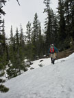
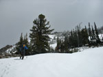
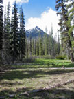
We crossed the bridge over the Teanaway River and soon hit snow. It was dark and cloudy with some rain for most of the drive over. At the trailhead it was cloudy but dry. Not too far beyond the Teanaway River bridge we hit snow. Patchy at first but soon it was getting more like winter. There were plenty of small trillium blooming and some glacier lilies as well. We saw no footprints even though there was a recent trip report. Lots of melting even with the colder recent temperatures.
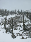
The bridge over De Roux Creek was snow free. Soon after we reached the junction with the trail to Koppen Mountain. Finally we began to climb. There is a blowdown blocking the trail soon encountered that requires a bypass. As we reached an open area near but high above De Roux Creek the ground was bare. We had to check the route a few times but for the most part we were able to stay on the summer trail. The last part to the creek crossing is the toughest when there is snow.
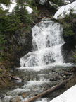
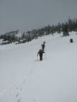
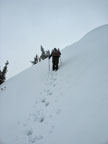
The trail cuts around the hillside to the north and the snow depth increased. The trail here is narrow as it hugs the steep hillside. Directly below is the creek as it drops through several waterfalls. A fall here might be fatal. Barry took the lead and went up and down finding a reasonable route. The exposure here was worse than any part of the actual snow scramble to the summit.
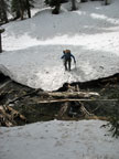
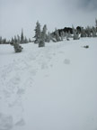
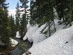
We dropped to the creek at a log jam than allowed us to get across with dry feet. Once across we headed up valley. The valley here is still mostly snow covered. After passing by a gentle rib we headed straight uphill. On the steeper slope much of the way was on slick muddy dirt. After a short climb we intersected the summer trail. There were patches of snow but for the most part it is now bare.
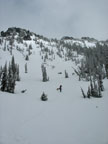
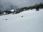
After reaching the big rock at the end of a rightward traverse we switchbacked left for a ways to where the trail passes just below the lip of a talus basin. Here we headed straight uphill. From the basin we could see a snowy slope to our left, a steeper snowy slope to our right and mostly bare dirt ahead. We went straight up. Farther left would have been better. A short steep climb brought us to another basin. Here I have usually climbed up boulders to another basin. Since we had a lot of snow now we chose to head left to an open snow slope.
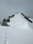
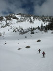
The snow was in great shape. Soft enough to allow deep solid steps but hard enough to hold our steps. Higher up we angled right through some trees to the upper basin. Now the route is very straight forward. Angle up the gentle gully to where the treed ridge on our right thins. There we easily passed through the thin forest to another open slope. This one leads directly up to the saddle between the two West Esmerelda Peaks. The only problem is I couldn't tell which saddle to aim for.
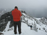
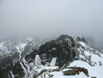
Barry and Suzanne were out ahead angling a little to the right. As we moved higher the saddle they were nearing did not look right to me. David and I angled over to the leftward saddle. Barry and Suzanne continued on and summited the eastern most summit. It is about the same elevation but is not considered to be the real summit. David and I reached the saddle. It was not corniced and we were able to head right across it. The wind began to really pick up above the saddle.
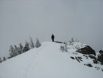
David went out ahead. We could not see if the ridge itself was corniced so he moved to the left side and kicked steps directly up. It was not much farther before he reached the real summit and I was close behind. By now Barry and Suzanne had down climbed from the other summit and were over at the saddle. They soon joined us. The summit register was right out in the open. David found that we were the first to sign this year. The last visitors were in November 2007. It was plenty windy on the summit and we all bundled up.
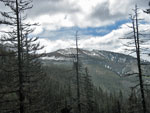
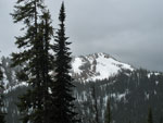
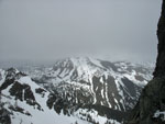
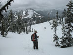
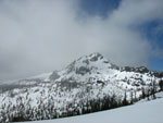
The views were less than spectacular. We could see the base of Hawkins, the base of De Roux, The base of Fortune, well you get the picture. We even had a little light snow falling. A walk to the west end of the summit revealed a view down to Gallagher Head Lake. It is still completely snow covered. We opted to drop down to the saddle for lunch. It was much less windy there. We did have a few cracks in the overcast and could see Koppen, De Roux, and Hawkins at times.
The descent was a lot less work than the ascent. We were able to plunge step the first open slope with no trouble. I tried to glissade but the whole 4-8 inches of fresh June snow went along with me. Back to plunge stepping. The second slope I was able to get in a bit of a glissade. We dropped a little too low here and ended up at the top of the boulder field. It's not to hard to descend when dry but it was covered with a layer of thin wet snow. Barry did descend it but the rest of us crossed the rocks snowy scree to the big open slope we had earlier climbed.
This one was long and steep enough to allow for a fun and fast glissade. I went first and David and Suzanne used my track to have a faster slide. Instead of dropping down the dirt slope we had climbed to the lowest basin we stayed well right and had an easy time plunge stepping down the snow. From there we dropped over the lip of the basin and quickly found our footprints up. The hike out was no problem.
We did pass two groups of two who were heading up to camp at Gallagher Head Lake. They were the only folks we saw all day. Esmerelda Peak is a big pile of scree. I have hiked it in the summer and it is a loose slidy mess. It is much more fun to climb on snow. The others added another Teanaway peak to their lists and I had a change to visit an old favorite. In a half dozen years I'm sure I'll be back. The weather kept improving and was pretty sunny at the trailhead. As we drove west the clouds descended and it was dark and wet. Heading east proved to be the best choice this day.
Suzanne's report is here: Nwhikers Report & Photos
Click on thumbnails to get larger pictures.
Trips - 2008
Home
We crossed the bridge over the Teanaway River and soon hit snow. It was dark and cloudy with some rain for most of the drive over. At the trailhead it was cloudy but dry. Not too far beyond the Teanaway River bridge we hit snow. Patchy at first but soon it was getting more like winter. There were plenty of small trillium blooming and some glacier lilies as well. We saw no footprints even though there was a recent trip report. Lots of melting even with the colder recent temperatures.
The bridge over De Roux Creek was snow free. Soon after we reached the junction with the trail to Koppen Mountain. Finally we began to climb. There is a blowdown blocking the trail soon encountered that requires a bypass. As we reached an open area near but high above De Roux Creek the ground was bare. We had to check the route a few times but for the most part we were able to stay on the summer trail. The last part to the creek crossing is the toughest when there is snow.
The trail cuts around the hillside to the north and the snow depth increased. The trail here is narrow as it hugs the steep hillside. Directly below is the creek as it drops through several waterfalls. A fall here might be fatal. Barry took the lead and went up and down finding a reasonable route. The exposure here was worse than any part of the actual snow scramble to the summit.
We dropped to the creek at a log jam than allowed us to get across with dry feet. Once across we headed up valley. The valley here is still mostly snow covered. After passing by a gentle rib we headed straight uphill. On the steeper slope much of the way was on slick muddy dirt. After a short climb we intersected the summer trail. There were patches of snow but for the most part it is now bare.
After reaching the big rock at the end of a rightward traverse we switchbacked left for a ways to where the trail passes just below the lip of a talus basin. Here we headed straight uphill. From the basin we could see a snowy slope to our left, a steeper snowy slope to our right and mostly bare dirt ahead. We went straight up. Farther left would have been better. A short steep climb brought us to another basin. Here I have usually climbed up boulders to another basin. Since we had a lot of snow now we chose to head left to an open snow slope.
The snow was in great shape. Soft enough to allow deep solid steps but hard enough to hold our steps. Higher up we angled right through some trees to the upper basin. Now the route is very straight forward. Angle up the gentle gully to where the treed ridge on our right thins. There we easily passed through the thin forest to another open slope. This one leads directly up to the saddle between the two West Esmerelda Peaks. The only problem is I couldn't tell which saddle to aim for.
Barry and Suzanne were out ahead angling a little to the right. As we moved higher the saddle they were nearing did not look right to me. David and I angled over to the leftward saddle. Barry and Suzanne continued on and summited the eastern most summit. It is about the same elevation but is not considered to be the real summit. David and I reached the saddle. It was not corniced and we were able to head right across it. The wind began to really pick up above the saddle.
David went out ahead. We could not see if the ridge itself was corniced so he moved to the left side and kicked steps directly up. It was not much farther before he reached the real summit and I was close behind. By now Barry and Suzanne had down climbed from the other summit and were over at the saddle. They soon joined us. The summit register was right out in the open. David found that we were the first to sign this year. The last visitors were in November 2007. It was plenty windy on the summit and we all bundled up.
The views were less than spectacular. We could see the base of Hawkins, the base of De Roux, The base of Fortune, well you get the picture. We even had a little light snow falling. A walk to the west end of the summit revealed a view down to Gallagher Head Lake. It is still completely snow covered. We opted to drop down to the saddle for lunch. It was much less windy there. We did have a few cracks in the overcast and could see Koppen, De Roux, and Hawkins at times.
The descent was a lot less work than the ascent. We were able to plunge step the first open slope with no trouble. I tried to glissade but the whole 4-8 inches of fresh June snow went along with me. Back to plunge stepping. The second slope I was able to get in a bit of a glissade. We dropped a little too low here and ended up at the top of the boulder field. It's not to hard to descend when dry but it was covered with a layer of thin wet snow. Barry did descend it but the rest of us crossed the rocks snowy scree to the big open slope we had earlier climbed.
This one was long and steep enough to allow for a fun and fast glissade. I went first and David and Suzanne used my track to have a faster slide. Instead of dropping down the dirt slope we had climbed to the lowest basin we stayed well right and had an easy time plunge stepping down the snow. From there we dropped over the lip of the basin and quickly found our footprints up. The hike out was no problem.
We did pass two groups of two who were heading up to camp at Gallagher Head Lake. They were the only folks we saw all day. Esmerelda Peak is a big pile of scree. I have hiked it in the summer and it is a loose slidy mess. It is much more fun to climb on snow. The others added another Teanaway peak to their lists and I had a change to visit an old favorite. In a half dozen years I'm sure I'll be back. The weather kept improving and was pretty sunny at the trailhead. As we drove west the clouds descended and it was dark and wet. Heading east proved to be the best choice this day.
Suzanne's report is here: Nwhikers Report & Photos
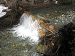
Small Falls |
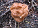
Unusual Fungus |
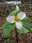
Trillium |
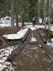
De Roux Bridge |
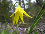
Glacier Lily |
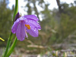
Droplets On Flower |
Iron Peak |
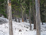
Snow Covered Trail |
Waterfall |
Suzanne Crossing Creek |
Ascending Above Creek |
De Roux Peak |
First Basin |
Boulder Field |
Ascending Snow |
Upper Basin |
Cloudy Hawkins |
Climbing To Summit |
David On Summit |
Others Are Near |
Other Summit |
At The Saddle |
Pinwheeling Snow |
David & De Roux |
Glissading! |
Hawkins Is Clear |
Lowest Basin |
Steep Snow Slope |
Clearing Over East Peak |
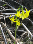
Quad Glacier Lily |
Trips - 2008
Home