3-16-08
Originally we were planning on Jim Hill Mountain. Trail
Pair were planning on Evergreen Mountain. More snow fell during the week
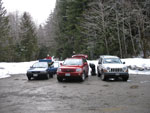
than expected so we switched to Evergreen. Suzanne, David, and I met at the
65th Street Park and Ride at 6:30 AM. We planned to meet at the trailhead
at 8:30 but we were way ahead of schedule. Joanna and Bruce were already
there and Bob and Kolleen were right behind us as we arrived at about 8:00
AM. Nikolai and his friend were the only ones missing.
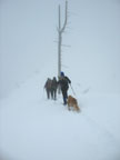
We waited until 8:35 then we chose to get moving. The usual route is via the old abandoned trail. It starts several miles up the Rapid River Road. Joanna and Bruce went up that way several weeks ago. They had deep unconsolidated snow and made it high on the ridge before heading down. On the way down they chose to leave the old route and headed straight down the ridge. They found a route marked with pink ribbons.
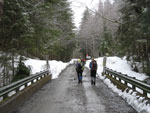
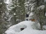
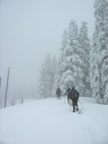
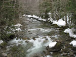
The plan this day was to ascend straight up the ridge. There is room for 5 or 6 cars at a small plowed lot where the Rapid River and Johnson Ridge Roads turn off the Beckler River Road. We followed the main road across the bridge over the Rapid River then put on snowshoes and headed up. Earlier in the week the forecast looked pretty good. Partly clear sky. By Saturday it started to look worse. It was completely cloudy and just above freezing when we started.
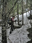
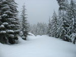
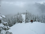
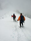
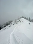
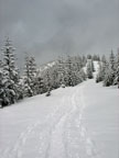
Right after leaving the road we found a pink ribbon. They continued all the way up. The snow was continuous but not deep. With snowshoes we did not posthole much at all. The route started gentle then steepened. It became pretty steep but never too steep. We climbed steadily. Slow but very direct. We started at 1387' and the summit is 5587'. A nice round 4200' of net gain. TOPO software showed our route to be a little less than 3 1/2 miles. There were even a few ups and downs on the ridge. That is steep.
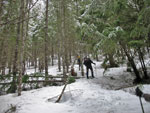
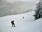
The slope became a more defined ridge and after some 1600' of gain the grade eased a little. We reached an old road here. We crossed that one or other roads several times. At about 3300" we took a food break on a section of road. I wanted to keep moving so I went out ahead. I gained about 300' to another road when the group caught up. In the trees the fresh snow was minimal but out in the open it was deeper.
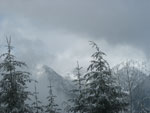
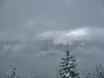
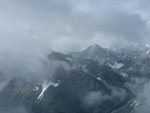
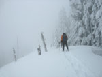
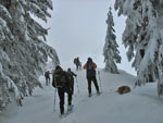
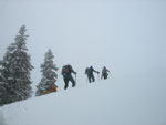
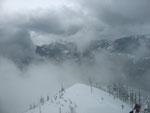
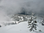
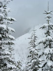
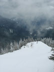
Above this last road we were more in the open. A trench began to form and I was glad we had as many folks as we had to trade off the lead. Bruce did much of the trail breaking along this stretch.. We had some peek a boo views over to Johnson Ridge but mostly it was just clouds. After the steep first 2000' it was a nice break to have gentler terrain. We continued up then had a short drop to a saddle near 4250'. We could see that it was time for more steep climbing from here.
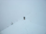
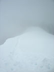
Joanna and Bruce had made it up another 500' on this section before they had to turn around on their previous trip. Above that we had no information. The ridge started broad and began to narrow. Visibility dropped as we were now in the clouds. I could barely see the steep edge of the ridge to our right. Even the narrowest section of ridge was wide enough for comfort. Steep slope on the left and a small bit of cornice on the right.
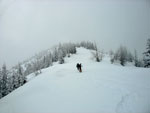
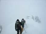
I took another lead on the steepest section. Sinking in 6 - 10 inches with each step was hard work but provided reasonably secure steps. At about 4850' the grade eased. Now we had a more gentle ridge with some trees again. There were also a a number of old silvered snags as well. We hit a high point at about 5500' only to descend to another saddle. Visibility dropped again and it became hard to see the right side of the ridge though it was only a few feet away. A step off there would lead to a long unplanned glissade.
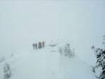
The ridge steepened again. We knew we were getting close but could not see much of anything. David was out ahead as we worked our way up the last bit. The GPS and altimeters said we were there but we saw nothing but white ground and white sky merging together. The ridge dropped and David could not tell if it was a long drop off or just a short one. He poked the snow and air before moving slowly ahead. Ironically, we were within 100' of the lookout building.
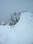
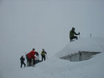
Eagle eyed members of the group spied the building though with glasses and sunglasses on my visibility was very limited. We approached the summit to find the lookout was 90% buried. Only a little bit of one corner was above the snow. I really want to come back in the summer to see just what it looks like without snow. We broke out clothing and food for a quick summit stay.
It began to snow or drop ice pellets. The wind picked up and it was pretty darn cold to be standing around. Suzanne and I headed down first as our hands were very cold. We saw David walk to the top of the lookout roof. It was more across than up and onto. After we left most of the others did the same. It took us 4:30 to ascend a scant 3 1/2 miles. We only took a few breaks and kept up a steady pace. I was surprised it took as long as it did.
The trip down was much faster and for the most part much easier. I was a little nervous about descending the steepest section of ridge with unconsolidated snow over a harder crust but it proved to be no problem. Of course, after we dropped 1000' there were some small sun breaks. They did not last long. We did get a few partial views across to the other side of the Beckler River.
We zoomed down to the last road crossing where the grade steepened sharply. The snow was thinner here and it was much warmer than on our ascent. Some folks took off their snowshoes and the rest of us did a little lower. The thin but mostly firm morning snow was now soft slop. Worse still we had numerous post holes that were at times thigh deep. I had to go slow as any step could leave me with one leg buried deep.
This was in some ways harder than the steep ascent. It was faster but very much hard work. At long last we popped out onto the Beckler Road and were quickly back at our cars. It took us only 2:30 to descend from the summit. For the day it was 7 miles in 7 hours with about 4500' of total elevation gain.. It left us all anxious to see what the views are like from the long ridge walk on a sunny day.
This was the second week in a row we took a very short summer hike to a lookout and make it into a very long and steep climb in the winter. Red Top Lookout was all blue sky and Evergreen was just about the opposite. Visibility was really minimal near the summit. It was a fun group and a steep but very reasonable route. At no time did anyone ever take out their ice axe. At least we did not get rained on, snow fall was short and only at the summit, and the wind was light most of the day. All in all a fun adventure to a place I had never visited.
David's trip report is here: Nwhikers Report & Photos
Click on thumbnails to get larger pictures.
Trips - 2008
Home
We waited until 8:35 then we chose to get moving. The usual route is via the old abandoned trail. It starts several miles up the Rapid River Road. Joanna and Bruce went up that way several weeks ago. They had deep unconsolidated snow and made it high on the ridge before heading down. On the way down they chose to leave the old route and headed straight down the ridge. They found a route marked with pink ribbons.
The plan this day was to ascend straight up the ridge. There is room for 5 or 6 cars at a small plowed lot where the Rapid River and Johnson Ridge Roads turn off the Beckler River Road. We followed the main road across the bridge over the Rapid River then put on snowshoes and headed up. Earlier in the week the forecast looked pretty good. Partly clear sky. By Saturday it started to look worse. It was completely cloudy and just above freezing when we started.
Right after leaving the road we found a pink ribbon. They continued all the way up. The snow was continuous but not deep. With snowshoes we did not posthole much at all. The route started gentle then steepened. It became pretty steep but never too steep. We climbed steadily. Slow but very direct. We started at 1387' and the summit is 5587'. A nice round 4200' of net gain. TOPO software showed our route to be a little less than 3 1/2 miles. There were even a few ups and downs on the ridge. That is steep.
The slope became a more defined ridge and after some 1600' of gain the grade eased a little. We reached an old road here. We crossed that one or other roads several times. At about 3300" we took a food break on a section of road. I wanted to keep moving so I went out ahead. I gained about 300' to another road when the group caught up. In the trees the fresh snow was minimal but out in the open it was deeper.
Above this last road we were more in the open. A trench began to form and I was glad we had as many folks as we had to trade off the lead. Bruce did much of the trail breaking along this stretch.. We had some peek a boo views over to Johnson Ridge but mostly it was just clouds. After the steep first 2000' it was a nice break to have gentler terrain. We continued up then had a short drop to a saddle near 4250'. We could see that it was time for more steep climbing from here.
Joanna and Bruce had made it up another 500' on this section before they had to turn around on their previous trip. Above that we had no information. The ridge started broad and began to narrow. Visibility dropped as we were now in the clouds. I could barely see the steep edge of the ridge to our right. Even the narrowest section of ridge was wide enough for comfort. Steep slope on the left and a small bit of cornice on the right.
I took another lead on the steepest section. Sinking in 6 - 10 inches with each step was hard work but provided reasonably secure steps. At about 4850' the grade eased. Now we had a more gentle ridge with some trees again. There were also a a number of old silvered snags as well. We hit a high point at about 5500' only to descend to another saddle. Visibility dropped again and it became hard to see the right side of the ridge though it was only a few feet away. A step off there would lead to a long unplanned glissade.
The ridge steepened again. We knew we were getting close but could not see much of anything. David was out ahead as we worked our way up the last bit. The GPS and altimeters said we were there but we saw nothing but white ground and white sky merging together. The ridge dropped and David could not tell if it was a long drop off or just a short one. He poked the snow and air before moving slowly ahead. Ironically, we were within 100' of the lookout building.
Eagle eyed members of the group spied the building though with glasses and sunglasses on my visibility was very limited. We approached the summit to find the lookout was 90% buried. Only a little bit of one corner was above the snow. I really want to come back in the summer to see just what it looks like without snow. We broke out clothing and food for a quick summit stay.
It began to snow or drop ice pellets. The wind picked up and it was pretty darn cold to be standing around. Suzanne and I headed down first as our hands were very cold. We saw David walk to the top of the lookout roof. It was more across than up and onto. After we left most of the others did the same. It took us 4:30 to ascend a scant 3 1/2 miles. We only took a few breaks and kept up a steady pace. I was surprised it took as long as it did.
The trip down was much faster and for the most part much easier. I was a little nervous about descending the steepest section of ridge with unconsolidated snow over a harder crust but it proved to be no problem. Of course, after we dropped 1000' there were some small sun breaks. They did not last long. We did get a few partial views across to the other side of the Beckler River.
We zoomed down to the last road crossing where the grade steepened sharply. The snow was thinner here and it was much warmer than on our ascent. Some folks took off their snowshoes and the rest of us did a little lower. The thin but mostly firm morning snow was now soft slop. Worse still we had numerous post holes that were at times thigh deep. I had to go slow as any step could leave me with one leg buried deep.
This was in some ways harder than the steep ascent. It was faster but very much hard work. At long last we popped out onto the Beckler Road and were quickly back at our cars. It took us only 2:30 to descend from the summit. For the day it was 7 miles in 7 hours with about 4500' of total elevation gain.. It left us all anxious to see what the views are like from the long ridge walk on a sunny day.
This was the second week in a row we took a very short summer hike to a lookout and make it into a very long and steep climb in the winter. Red Top Lookout was all blue sky and Evergreen was just about the opposite. Visibility was really minimal near the summit. It was a fun group and a steep but very reasonable route. At no time did anyone ever take out their ice axe. At least we did not get rained on, snow fall was short and only at the summit, and the wind was light most of the day. All in all a fun adventure to a place I had never visited.
David's trip report is here: Nwhikers Report & Photos
Parking Lot |
Rapid River Bridge |
Joanna |
Open Forest |
Snowy Bump |
Road Crossing |
A Little View |
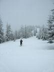
Lone Snowshoer |
Flat Then Steepr |
Johnson Ridge |
Gentler Grade |
Kolleen |
Better View |
Tuning Fork Tree |
Very Narrow Ridge |
Ridge Flattens |
Forest Resumes |
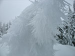
Hoar Frost |
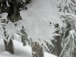
More Frost |
Short Break |
Getting Close |
That's It? |
Final Ridge |
Evergreen Lookout |
Minimal Visibility |
Stay Right |
Kolleen & Bob |
Shades Of Gray |
Clearer |
Valley Far Below |
Wild Sky Peaks |
More Of Ridge |
Easy Walking |
Open Ridge Walking |
Rapid River |
Trips - 2008
Home