1-13-08
A sunny winter day is in the offing. What to do? Must
get up above the trees to take advantage of the day. This trip requires
two hours of driving so I was up at 5:00 am and over at Suzanne's at 6:00.
I was surprised to see we had a new member of our hiking group this day.
Gusto the golden retriever is Suzanne's new addition. This would be his first
time on a snowshoe trip. We picked up Elle at the Preston P&R and were
on our way east. There was a little rain that was not supposed to happen
but it soon was gone. We sailed over Snoqualmie Pass in clouds and finally
broke out to some early morning sun.
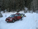
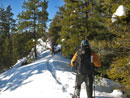
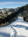
At Cle Elum we turned north on 970 which soon becomes Highway 97. At 2.3 miles north of Mineral Springs Resort we found the small plowed start of the Iron Creek Road. Room for 4 to 5 cars. It was sunny and 21 degrees. Thankfully there was no wind. Bob and Kolleen soon arrived to fill out our group. The Iron Creek Road immediately turns right and the Hovey Creek Road goes left. I have been down the Iron Creek Road a number of times hiking the Iron Creek Trail to Teanaway Ridge and points beyond. This day we were heading left.
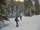
A snowmobile had recently run up the Hovey Road. Good thing. Off the track the snow was plenty deep. John Morrow had suggested this route to Suzanne and none of us had ever been on any of it. The map showed the road split at about one mile. Our road went off to the right and climbed up to the ridge top next to Point 4002. The start is at about 2950'. The top of Teanawy Ridge, our goal this day, is at 4943'. Although the snowmobile track was pretty solid we chose to start with our snowshoes on.
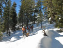
I was already pretty cold but began to warm up as we trod down the road. We came to an obvious road to the right. The only one on the maps is the one we wanted. The road seemed to come up too early. After a short debate we chose to take the side road. It wound it's way higher until either it ended or I lost it. The slope was fairly steep but the footing was good and we headed straight up. We soon found ourselves on the ridge top...and on a road! Hmm... that wasn't supposed to be there.
More map checking ensued and we chose to follow the road to our left. It dropped down, reached another ridge crest and then began to drop to the Iron Creek Valley. There were timber survey markers on the trees so it looks like a cutting may be coming. We had no interest in dropping to the other valley so we climbed along the ridge crest. By now it was obvious we reached the ridge much to early. The correct road was heading up the valley and slowly gaining elevation. We were already on the ridge.
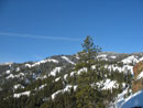
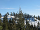
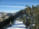
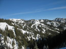
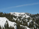
The only thing to do was to enjoy an extra long ridge walk in the sun. Not such a bad price to pay for a route finding mess up. The ridge was a real joy. Sometimes on the very narrow top and sometimes down to avoid rocky bumps them back to the ridge top. Soon I could see Teanaway Ridge and even Red Top Lookout. There was still no wind and it was rapidly warming. We did not know what to expect from Gusto but he had no trouble keeping up with us. He soon learned that the trench was much better than slogging in deep soft snow.
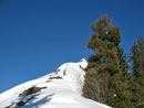
The ridge has some twists and turns as we headed generally in the right direction. At one point the group stopped for a break. It was my turn to lead and I chose to go ahead. The ridge looked to curve left so I dropped down and climbed up on a more direct route. Here the ridge became narrow and a bit cliffy. The snow was soft enough to set deep tracks for security. Suzanne and Gust soon caught up with me. It began to look like we might be running into a dead end. Again I pulled out my map.
The rocky points of our ridge helped to verify our position. If I was right then the correct road was now just below us on the other side of the ridge. If we could just go a little farther the road should come up and almost reach us. The rest of the group now caught up and we headed on just to the right of the now knife edge ridge. We were forced lower and it was soon clear that there was no reasonable way to go forward. If we backtracked far enough we might find a place to drop down to the ridge.
Before doing that I decided to climb up to the ridge top and see if I could see the road below. I pulled myself up to the top and found a break in the cliff. Maybe 70 or so feet below on a steep snow slope was what looked like the road. I called everyone else up and began a steep decent. Thankfully the snow was soft enough to set some decent steps. A few minutes later I was on the road. The others soon followed.
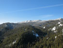
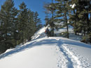
Now we were back on track. We took an interesting detour that gave us a high ridge walk instead of a forest road walk. It added elevation gain and took longer but was a lot of fun. The road reached then contoured around Point 4002. At the far side of the point it ended. Now we had about 1000' of ridge climbed to reach the top of Teanaway Ridge. It felt like about 50 degrees now. In fact it looked and felt like late March not early January. The warmth had changed the texture of the snow. Now Gusto had dozens of big snowballs hanging from him. As fast as we removed them they returned.
We climbed a few hundred feet up the ridge and Suzanne and I decided that enough was enough. It was Gusto's first snow hike and now the snow was at the worst possible consistency for a dog. The Ridge top would wait for another day. We did have gorgeous views from our turn around point. Elle decided she would go back with us. Bob and Kolleen chose to take a shot at the ridge top. In fact they did make it much farther before a possibly unstable slope caused them to turn around as well.
Descending in our own track was not hard at all. We made good time to the point where we dropped to the road. From there we had to break trail once again. At least it was much easier breaking trail downhill. I was very interested to see where we hit the main road. There was one more junction. This one went uphill left or downhill right. Though we needed to head leftward we chose the downhill road and that was correct.
Where we reached the main road there was just the very top of a road marker. Another foot or less of snow and it will be buried. The road was not as obvious as the one we mistakenly took in the morning but if you are looking for it you should find it. We met two skier coming up. They were the only people we saw all day. They had planned to ski near Snoqualmie Pass but all the sno-park lots were full. They drove all the way over here to find a place.
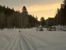
For the day we snowhoed almost 6 miles and gained about 1600'. We had packed road, steep climbing, ridge running, a steep descent, and great views all around. We did not reach the top of Teanaway Ridge but the day was anything but a failure. We had the chance to explore a new area on a bright sunny day. Best of all was the ridge walking. I'm sure we will be back for more exploration in the not too distant future.
Suzanne's report and photos are here: Nwhikers Report
Click on thumbnails to get larger pictures.
Trips - 2008
Home
At Cle Elum we turned north on 970 which soon becomes Highway 97. At 2.3 miles north of Mineral Springs Resort we found the small plowed start of the Iron Creek Road. Room for 4 to 5 cars. It was sunny and 21 degrees. Thankfully there was no wind. Bob and Kolleen soon arrived to fill out our group. The Iron Creek Road immediately turns right and the Hovey Creek Road goes left. I have been down the Iron Creek Road a number of times hiking the Iron Creek Trail to Teanaway Ridge and points beyond. This day we were heading left.
A snowmobile had recently run up the Hovey Road. Good thing. Off the track the snow was plenty deep. John Morrow had suggested this route to Suzanne and none of us had ever been on any of it. The map showed the road split at about one mile. Our road went off to the right and climbed up to the ridge top next to Point 4002. The start is at about 2950'. The top of Teanawy Ridge, our goal this day, is at 4943'. Although the snowmobile track was pretty solid we chose to start with our snowshoes on.
I was already pretty cold but began to warm up as we trod down the road. We came to an obvious road to the right. The only one on the maps is the one we wanted. The road seemed to come up too early. After a short debate we chose to take the side road. It wound it's way higher until either it ended or I lost it. The slope was fairly steep but the footing was good and we headed straight up. We soon found ourselves on the ridge top...and on a road! Hmm... that wasn't supposed to be there.
More map checking ensued and we chose to follow the road to our left. It dropped down, reached another ridge crest and then began to drop to the Iron Creek Valley. There were timber survey markers on the trees so it looks like a cutting may be coming. We had no interest in dropping to the other valley so we climbed along the ridge crest. By now it was obvious we reached the ridge much to early. The correct road was heading up the valley and slowly gaining elevation. We were already on the ridge.
The only thing to do was to enjoy an extra long ridge walk in the sun. Not such a bad price to pay for a route finding mess up. The ridge was a real joy. Sometimes on the very narrow top and sometimes down to avoid rocky bumps them back to the ridge top. Soon I could see Teanaway Ridge and even Red Top Lookout. There was still no wind and it was rapidly warming. We did not know what to expect from Gusto but he had no trouble keeping up with us. He soon learned that the trench was much better than slogging in deep soft snow.
The ridge has some twists and turns as we headed generally in the right direction. At one point the group stopped for a break. It was my turn to lead and I chose to go ahead. The ridge looked to curve left so I dropped down and climbed up on a more direct route. Here the ridge became narrow and a bit cliffy. The snow was soft enough to set deep tracks for security. Suzanne and Gust soon caught up with me. It began to look like we might be running into a dead end. Again I pulled out my map.
The rocky points of our ridge helped to verify our position. If I was right then the correct road was now just below us on the other side of the ridge. If we could just go a little farther the road should come up and almost reach us. The rest of the group now caught up and we headed on just to the right of the now knife edge ridge. We were forced lower and it was soon clear that there was no reasonable way to go forward. If we backtracked far enough we might find a place to drop down to the ridge.
Before doing that I decided to climb up to the ridge top and see if I could see the road below. I pulled myself up to the top and found a break in the cliff. Maybe 70 or so feet below on a steep snow slope was what looked like the road. I called everyone else up and began a steep decent. Thankfully the snow was soft enough to set some decent steps. A few minutes later I was on the road. The others soon followed.
Now we were back on track. We took an interesting detour that gave us a high ridge walk instead of a forest road walk. It added elevation gain and took longer but was a lot of fun. The road reached then contoured around Point 4002. At the far side of the point it ended. Now we had about 1000' of ridge climbed to reach the top of Teanaway Ridge. It felt like about 50 degrees now. In fact it looked and felt like late March not early January. The warmth had changed the texture of the snow. Now Gusto had dozens of big snowballs hanging from him. As fast as we removed them they returned.
We climbed a few hundred feet up the ridge and Suzanne and I decided that enough was enough. It was Gusto's first snow hike and now the snow was at the worst possible consistency for a dog. The Ridge top would wait for another day. We did have gorgeous views from our turn around point. Elle decided she would go back with us. Bob and Kolleen chose to take a shot at the ridge top. In fact they did make it much farther before a possibly unstable slope caused them to turn around as well.
Descending in our own track was not hard at all. We made good time to the point where we dropped to the road. From there we had to break trail once again. At least it was much easier breaking trail downhill. I was very interested to see where we hit the main road. There was one more junction. This one went uphill left or downhill right. Though we needed to head leftward we chose the downhill road and that was correct.
Where we reached the main road there was just the very top of a road marker. Another foot or less of snow and it will be buried. The road was not as obvious as the one we mistakenly took in the morning but if you are looking for it you should find it. We met two skier coming up. They were the only people we saw all day. They had planned to ski near Snoqualmie Pass but all the sno-park lots were full. They drove all the way over here to find a place.
For the day we snowhoed almost 6 miles and gained about 1600'. We had packed road, steep climbing, ridge running, a steep descent, and great views all around. We did not reach the top of Teanaway Ridge but the day was anything but a failure. We had the chance to explore a new area on a bright sunny day. Best of all was the ridge walking. I'm sure we will be back for more exploration in the not too distant future.
Suzanne's report and photos are here: Nwhikers Report
Trailhead |
Start Of Road |
XC Trail Marker |
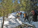
Bob & Kolleen |
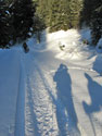
Shadows |
Climbing Off Road |
On The Ridge |
Red Top Lookout |
Kolleen On Ridge |

Detour Time |
Ridge Flattens |
Narrow Ridge |
Teanaway Ridge |
Our Goal Is Ahead |
Steep Descent |
Descent Ridge |
Back Off Road |
Point 4002 |
Iron Creek |
Iron Bear Pass Area |
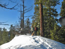
Ridge Bump |
Trench |
Suzanne & Gusto |

Elle & Suzanne |
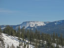
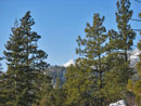
Table Mountain |
Trips - 2008
Home