4/26-27/08
The Teanaway area is officially open for business.
The last few years I've started my backpacking season with a late winter
or early spring camp on top of a Teanaway Peak. Two solo trips to Iron Peak,
A group camp below Earl Peak's summit, and one to Navaho Peak's saddle
with summits of Navaho and Little Navaho. This year I convinced Bob, Kolleen,
and David to accompany me back to Iron Peak. We met in Bellevue at 6:30
and headed off to the Teanaway. We all crammed into David's Outback. I was
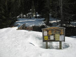
surprised we were able to drive half a mile beyond 29 Pines campground.
There was snow and bare spots on the road.
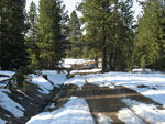
By 8:35 we were packed up and on the road. There were a few more bare spots but the road is still mostly snow covered. It was just over 32 degrees and the road was groomed all winter for snowmobiles. It is very hard packed. It would have been possible to drive a ways farther on top of the snow. The problem is that afternoon melting would likely have stranded a car up the road. It will be at least another few weeks before the road is bare to Stafford Creek. After Stafford we saw a bobcat! It was the first sighting in the wild for all of us.
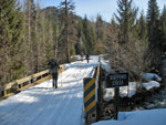
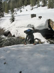
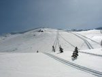
It was sunny and warming rapidly. We made good time on the nearly flat road. At Beverly Creek we turned right and began to ascend the Beverly Road. We reached the Beverly trailhead at 10:20. Four and a half miles in 1:45, almost all on snow. The parking lot has about 3 feet of snow. The hiker bridge is half snow and half bare. We crawled down to the bridge deck easily enough. Getting back up the other side was much more difficult. The snow was rock hard. With great difficulty we scrambled up the other side.
Half a mile up the road we came to Bean Creek. In the early spring the creek can be totally covered by a snow bridge or a raging torrent. This time it wasn't bad. All the channels were covered by snow except a 4 foot wide stream. It was easy enough to climb down the snow bank. When it was my turn to cross. I reached my leg across to a rock on the other side. I planted both poles in the water and pushed off. At that moment my left pole collapsed and I did a slow motion spin down and into the water.
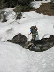
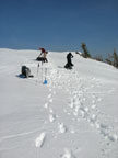
At first I thought the only damage was to my pride. I landed in all of 8 inches of water left knee first onto a rock. I managed to submerge my pants. I got up and climbed out. The knee stung but I thought nothing of it. A little farther ahead the route traversed above the creek on a steep slope. The summer trail was buried. We kicked steps across. It was soft enough to kick steps but hard enough to make them less than comfortable.
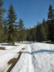
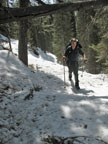
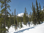
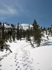
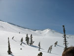
We followed a single set of ski tracks. They continued all the way up into the basin. Eventually we saw them on the side of Bill Peak. We crossed the boulder field that was all under many feet of snow. By now my knee was beginning to hurt more. I was down to shorts and a short sleeve shirt. It felt like spring at last. We popped out of the forest into the lower basin. The summer trail switchbacks high on the right side of the valley. With all the snow we just kept to the right of the creek.
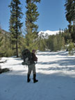
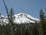
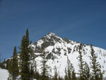
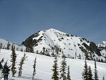
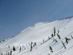
By now I was lagging farther behind the group. My knee was killing me. We crossed the creek before the summer trail does. Our route was mostly straight up the slope. I took some Motrin and that helped the pain. On snow I always aim for a gap in the huge cornices just to the right of the summit of Iron. The NW Avalanche Center warned of high danger on east facing slopes from the heat and direct sun exposure. I figured we may have to go farther right to nearer the saddle below Teanaway Peak. The climb to the ridge is much shorter there.
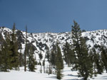
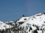
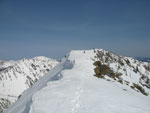
Kolleen kept booting it but Bob, David, and I stopped to put on snowshoes. We were sinking in 6" with every step. Looking up at the summit ridge the cornices were as big as I have seen. There were a number of snowmobile "high marking" tracks right up to the base of the cornices. Talk about putting your life on the line for a thrill... We had no interest in being below those cornices.
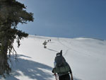
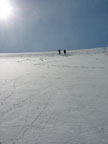
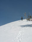
We stopped below my usual ascent spot and talked it over. It was soft here but I knew it would be harder higher up. With the variability of the snow and my bad knee we chose to traverse right to a short slope to the ridge top. We dropped into a snowmobile track and the going was easier. We took off snowshoes for the final climb to the ridge top. Bob and Kolleen were out in front and began to climb. The soft snow grew thinner and there was a rock hard layer beneath. While we saw numerous sloughs coming up the valley there were none on Iron Peak. Bob kicked nice steps and in short order we were on the ridge top.
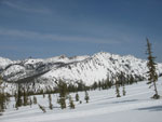
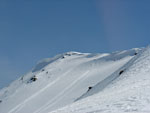
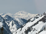
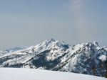
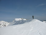
The last .40 miles gained another 350' to the summit. As we climbed the views became better and better. Earl, Bean, Volcanic Neck, Teanaway, Bill, and Stuart were in sight. On the other side of the ridge we could see Koppen, Jolly, Hawkins, and Esmerelda. Higher up Mt. Daniel came into view. It was clear enough to see Hibox, Three Queens, Chikamin, and other peaks of the Cascade crest.
We heard snowmobiles below soon after summiting. One of them roared up to the ridge top and sped along it to our position. He had seen our deep footprints in the valley and just had to see who was crazy enough to get all the way up here without a motor. He turned out to be a nice guy. We did not expect to be visited by a snowmobile on the summit but he was too nice to be mad about it.
Just below the summit we selected our camp sites. This was a Hilleberg convention as we had Bob and Kolleen's red Nallo 3, David's red Akto, and my green Akto. We took the better part of an hour to dig out platforms and set up camp. There was more snow on the summit than on either of my previous camp outs. We were all about out of water and melting snow was the next item on the agenda. High clouds came in from the west. We had high hopes for sunset colors. Unfortunately, the clouds kept on coming and blotted out the setting sun.
As the sun set the temperature plummeted. From shorts we moved onto long pants, goretex pants, down coats, and gloves. It was cold as we went to bed at about 8:30. I got up at 3:15 as nature called. The wind was calm and I found my leg was really painful now. I was getting concerned with a 8 1/2 mile descent with 4000' of elevation loss. The morning had more clouds and we did not get the warmth or the lighting we had hoped for. Still, the clouds were high and we had nice views to all the peaks around us.
I could not put much weight on my left leg. I was more concerned than ever. We pooled first aid kits. I put on an ace bandage and that helped. Next was more anti inflammatory medicine. The clincher was some high powered pain killer. That stuff really worked. We broke camp and I could now walk. The plan was to glissade the first 500' off the summit. We had hoped for some sun to soften up the slope. It was well below freezing over night. All our steps were frozen solid. The untouched snow was still pretty soft.
I went first. I've done this glissade many times. In fact it was slower than expected. Some snow built up between my legs. I managed to get almost to the bottom but not at the exhilarating speeds often felt. The slope had some soft snow on top of a hard layer. The others had my track to follow and had a better ride. In short order we were down the first slope. I was moving slow but moving as we continued down.
The walk out was painful but not nearly as bad as I had feared in the morning. We continued down the valley, across Bean Creek, and back to the summer trailhead. The snow was softer than the day before but hard enough to avoid needing snowshoes all the way back. At 1:15 we arrived back at the car. We took 6 hours to ascend and 4 1/2 hours to come down.
The injury is the first one I have ever had on the trail. Still, it did not wreck our weekend. The sunshine on Saturday was spectacular. The views were just as good as I remember. The company was great. Even though we did not get the sunset and sunrise we expected the weekend was a success. Now I have to figure out what summit to camp on next spring.
Nwhikers report with photos from Bob, Kollen, and David: Nwhikers Report With Photos
Click on thumbnails to get larger pictures.
Photo Page 2
Trips - 2008
Home
By 8:35 we were packed up and on the road. There were a few more bare spots but the road is still mostly snow covered. It was just over 32 degrees and the road was groomed all winter for snowmobiles. It is very hard packed. It would have been possible to drive a ways farther on top of the snow. The problem is that afternoon melting would likely have stranded a car up the road. It will be at least another few weeks before the road is bare to Stafford Creek. After Stafford we saw a bobcat! It was the first sighting in the wild for all of us.
It was sunny and warming rapidly. We made good time on the nearly flat road. At Beverly Creek we turned right and began to ascend the Beverly Road. We reached the Beverly trailhead at 10:20. Four and a half miles in 1:45, almost all on snow. The parking lot has about 3 feet of snow. The hiker bridge is half snow and half bare. We crawled down to the bridge deck easily enough. Getting back up the other side was much more difficult. The snow was rock hard. With great difficulty we scrambled up the other side.
Half a mile up the road we came to Bean Creek. In the early spring the creek can be totally covered by a snow bridge or a raging torrent. This time it wasn't bad. All the channels were covered by snow except a 4 foot wide stream. It was easy enough to climb down the snow bank. When it was my turn to cross. I reached my leg across to a rock on the other side. I planted both poles in the water and pushed off. At that moment my left pole collapsed and I did a slow motion spin down and into the water.
At first I thought the only damage was to my pride. I landed in all of 8 inches of water left knee first onto a rock. I managed to submerge my pants. I got up and climbed out. The knee stung but I thought nothing of it. A little farther ahead the route traversed above the creek on a steep slope. The summer trail was buried. We kicked steps across. It was soft enough to kick steps but hard enough to make them less than comfortable.
We followed a single set of ski tracks. They continued all the way up into the basin. Eventually we saw them on the side of Bill Peak. We crossed the boulder field that was all under many feet of snow. By now my knee was beginning to hurt more. I was down to shorts and a short sleeve shirt. It felt like spring at last. We popped out of the forest into the lower basin. The summer trail switchbacks high on the right side of the valley. With all the snow we just kept to the right of the creek.
By now I was lagging farther behind the group. My knee was killing me. We crossed the creek before the summer trail does. Our route was mostly straight up the slope. I took some Motrin and that helped the pain. On snow I always aim for a gap in the huge cornices just to the right of the summit of Iron. The NW Avalanche Center warned of high danger on east facing slopes from the heat and direct sun exposure. I figured we may have to go farther right to nearer the saddle below Teanaway Peak. The climb to the ridge is much shorter there.
Kolleen kept booting it but Bob, David, and I stopped to put on snowshoes. We were sinking in 6" with every step. Looking up at the summit ridge the cornices were as big as I have seen. There were a number of snowmobile "high marking" tracks right up to the base of the cornices. Talk about putting your life on the line for a thrill... We had no interest in being below those cornices.
We stopped below my usual ascent spot and talked it over. It was soft here but I knew it would be harder higher up. With the variability of the snow and my bad knee we chose to traverse right to a short slope to the ridge top. We dropped into a snowmobile track and the going was easier. We took off snowshoes for the final climb to the ridge top. Bob and Kolleen were out in front and began to climb. The soft snow grew thinner and there was a rock hard layer beneath. While we saw numerous sloughs coming up the valley there were none on Iron Peak. Bob kicked nice steps and in short order we were on the ridge top.
The last .40 miles gained another 350' to the summit. As we climbed the views became better and better. Earl, Bean, Volcanic Neck, Teanaway, Bill, and Stuart were in sight. On the other side of the ridge we could see Koppen, Jolly, Hawkins, and Esmerelda. Higher up Mt. Daniel came into view. It was clear enough to see Hibox, Three Queens, Chikamin, and other peaks of the Cascade crest.
We heard snowmobiles below soon after summiting. One of them roared up to the ridge top and sped along it to our position. He had seen our deep footprints in the valley and just had to see who was crazy enough to get all the way up here without a motor. He turned out to be a nice guy. We did not expect to be visited by a snowmobile on the summit but he was too nice to be mad about it.
Just below the summit we selected our camp sites. This was a Hilleberg convention as we had Bob and Kolleen's red Nallo 3, David's red Akto, and my green Akto. We took the better part of an hour to dig out platforms and set up camp. There was more snow on the summit than on either of my previous camp outs. We were all about out of water and melting snow was the next item on the agenda. High clouds came in from the west. We had high hopes for sunset colors. Unfortunately, the clouds kept on coming and blotted out the setting sun.
As the sun set the temperature plummeted. From shorts we moved onto long pants, goretex pants, down coats, and gloves. It was cold as we went to bed at about 8:30. I got up at 3:15 as nature called. The wind was calm and I found my leg was really painful now. I was getting concerned with a 8 1/2 mile descent with 4000' of elevation loss. The morning had more clouds and we did not get the warmth or the lighting we had hoped for. Still, the clouds were high and we had nice views to all the peaks around us.
I could not put much weight on my left leg. I was more concerned than ever. We pooled first aid kits. I put on an ace bandage and that helped. Next was more anti inflammatory medicine. The clincher was some high powered pain killer. That stuff really worked. We broke camp and I could now walk. The plan was to glissade the first 500' off the summit. We had hoped for some sun to soften up the slope. It was well below freezing over night. All our steps were frozen solid. The untouched snow was still pretty soft.
I went first. I've done this glissade many times. In fact it was slower than expected. Some snow built up between my legs. I managed to get almost to the bottom but not at the exhilarating speeds often felt. The slope had some soft snow on top of a hard layer. The others had my track to follow and had a better ride. In short order we were down the first slope. I was moving slow but moving as we continued down.
The walk out was painful but not nearly as bad as I had feared in the morning. We continued down the valley, across Bean Creek, and back to the summer trailhead. The snow was softer than the day before but hard enough to avoid needing snowshoes all the way back. At 1:15 we arrived back at the car. We took 6 hours to ascend and 4 1/2 hours to come down.
The injury is the first one I have ever had on the trail. Still, it did not wreck our weekend. The sunshine on Saturday was spectacular. The views were just as good as I remember. The company was great. Even though we did not get the sunset and sunrise we expected the weekend was a success. Now I have to figure out what summit to camp on next spring.
Nwhikers report with photos from Bob, Kollen, and David: Nwhikers Report With Photos
Parking Spot |
Stafford Creek |
A Small Bare Spot |
Beverly Road |
Beverly Trailhead |
Scrambling Off Bridge |
Crossing Bean Creek |
David On Route |
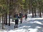
In Forest |
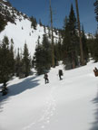
Leaving Forest |
Valley Wall |
First Peak View |
Iron Peak Summit |
Beyond The Creek |
Bill Peak |
Volcanic Neck |
Corniced Ridge |
Usual Route Up & Down |
View East |
Teanaway Peak |
Glissade Route |
Nearing Ridge |
Almost To Ridge Top |
Summit From Ridge |
Mt. Daniel |
Hawkins & Esmerelda |
Last Climb |
Summit Ahead |
Nearly To Campsite |
At Campsite |
Photo Page 2
Trips - 2008
Home