4-06-08
Another weekend and another crummy weather forecast.
The central Cascades were due for 1-3 inches of snow with the snow level
at 2000'. No views and no reason to drive very far. The east side of the
mountains looked to be about the same. With that in mind we kicked around
a few ideas and settled on West Granite Mountain. Everyone in our group had
done Granite multiple times but only Carla had done West Granite. I have hiked
up to the Pratt - Granite Ridge many times in winter and knew that ridge
goes up the west peak.
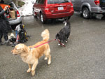
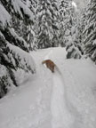
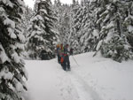
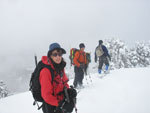
Suzanne, David, Carla, Bob, Kolleen, and I met at the Pratt Lake Trailhead at 8:30. Joe came along too though he had to be home earlier and just went to Olallie Lake. It was snowing as we got ready. By 8:40 we were on our way. There were a few patches of dirt near the start but the route was otherwise entirely on snow. There were some footprints showing so we did not need snowshoes for a long while. One tree is down near the start then the trail is fine.
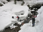
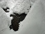
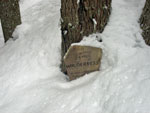
The creek crossings were no problem. There is a lot of snow. More than I can recall on this trail. We were able to climb down then rock hop the creeks. The wilderness boundary sign is almost under snow. Just the top half of it is still showing at foot level. We did not see the Talapus-Olallie Lakes signs. I'm pretty sure we were on the summer trail. I think the signs were just under the snow.
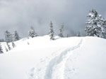
I planned to go up the valley to the Olallie Lake inlet creek then head straight uphill to the northwest ridge of West Granite. Instead the trench in the snow turned uphill much earlier. We were probably about in the middle of Olallie Lake when we headed uphill. The snow was now pretty deep staying in the trench was the way to go. I just hoped it went where we wanted to go.
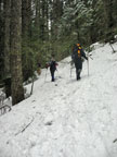
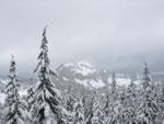
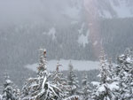
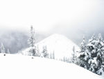
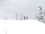
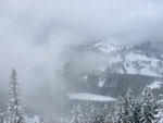
It did not take much climbing until we stopped to put on snowshoes. The route was generally moderate with a few steeper sections. Higher up we met a lone woman who was improving the previous day's trench. We passed her and did not see her again. Part way up the slope we had a break in the trees and in the clouds and could see a little of Bandera Mountain. and most all of Pratt Mountain. Olallie Lake was just below us.
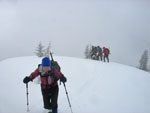
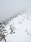
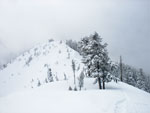
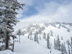
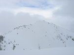
Back in the forest we continued climbing. We left the summer route at about 3800' and reached the southwest ridge at about 4800'. There are some trees on the ridge but it is largely in the open. The snow was deeper here and the trench was mostly buried. We took turns leading in the soft snow. At about 5125' is the summit of a bump on the ridge. Carla calls it Red 2 as there is a red 2 located there on the map.
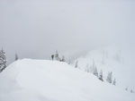
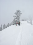
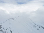
From the top of Red 2 we lost some 80' then began the final climb to the summit of West Granite. Thankfully there was little wind as it was cloudy and cold. We could not see the summit of West or main Granite through the haze. After making good time along the summer route our pace dropped significantly as most of the elevation gain was in the last 1 1/2 miles and the snow was deeper.
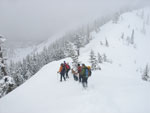
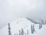
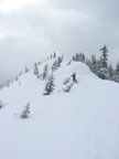
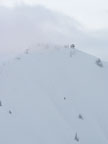
The grade up the final climb was not too bad. My altimeter was more useful than my eyes as I could not see the top until we were within about 30'. On the last climb two other snowshoers caught up with us. One of them was on his first ever snowshoe trip. Most folks wouldn't call a 3900' climb a normal first trip. The summit of West Granite is at 5566'. Main Granite is only 63' higher at 5629'. I'm sure there are great views from the top. I'm sure I'll have to go back to see them. Visibility was minimal. We arrived at 12:40. It took us four hours to summit.
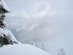
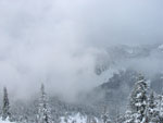
Several of us went to the west side of the summit to try to get out of the wind. The others went to the other side. There was at least a few feet of fresh snow on top. By the time we finished lunch and prepared to head down there were a few breaks in the clouds. The lookout on Granite even came into view for a few seconds. Ascending the ridge in soft snow was a lot of work. The descent was fun. I wa able to almost plunge step in snowshoes.
We made good time coming down. More cloud breaks allowed views to the summit of Granite, West Granite, Bandera, and Pratt Mountains. Olallie Lake was visible as well. The break did not last long. Soon it was snowing again. We dropped to the saddle and headed back over Red 2. Along here we met a lone skier head up. The drop off the ridge was more fun. The snow was soft and even the steep part was a plunge stepping sliding romp. In no time at all we were back to the summer route.
The rest of the hike down was a long slog. The snow was now well packed and very slick. I managed to fall off the trail at one point. Climbing out of the tree well was no fun. Other than that it was no problem. We reached the cars 2:17 after leaving the summit. For the day we traveled about 9 1/2 miles with 3900' of gain. The weather was not great but not all that bad either. We were snowed on but did not have rain.
I have looked over at West Granite from Granite, Pratt, Bandera, Defiance, Humpback, Silver, Catherine, Kaleetan, and other summits. It was fun to finally get up there. We had a good group with many of the usuals and it was great to have Carla along as well. The calendar says it's spring but it sure seemed like winter in the mountains for yet another week.
Suzanne's report is here: NWhikers Report & Photos
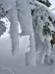
These are some of the grainiest photos I have taken. When I returned home I realized that I had accidently set the ISO for 400 at some point in the trip. Operator error for sure. I included the photos to document the trip but they are mostly subpar. Next trip should be fine.
Click on thumbnails to get larger pictures.
Trips - 2008
Home
Suzanne, David, Carla, Bob, Kolleen, and I met at the Pratt Lake Trailhead at 8:30. Joe came along too though he had to be home earlier and just went to Olallie Lake. It was snowing as we got ready. By 8:40 we were on our way. There were a few patches of dirt near the start but the route was otherwise entirely on snow. There were some footprints showing so we did not need snowshoes for a long while. One tree is down near the start then the trail is fine.
The creek crossings were no problem. There is a lot of snow. More than I can recall on this trail. We were able to climb down then rock hop the creeks. The wilderness boundary sign is almost under snow. Just the top half of it is still showing at foot level. We did not see the Talapus-Olallie Lakes signs. I'm pretty sure we were on the summer trail. I think the signs were just under the snow.
I planned to go up the valley to the Olallie Lake inlet creek then head straight uphill to the northwest ridge of West Granite. Instead the trench in the snow turned uphill much earlier. We were probably about in the middle of Olallie Lake when we headed uphill. The snow was now pretty deep staying in the trench was the way to go. I just hoped it went where we wanted to go.
It did not take much climbing until we stopped to put on snowshoes. The route was generally moderate with a few steeper sections. Higher up we met a lone woman who was improving the previous day's trench. We passed her and did not see her again. Part way up the slope we had a break in the trees and in the clouds and could see a little of Bandera Mountain. and most all of Pratt Mountain. Olallie Lake was just below us.
Back in the forest we continued climbing. We left the summer route at about 3800' and reached the southwest ridge at about 4800'. There are some trees on the ridge but it is largely in the open. The snow was deeper here and the trench was mostly buried. We took turns leading in the soft snow. At about 5125' is the summit of a bump on the ridge. Carla calls it Red 2 as there is a red 2 located there on the map.
From the top of Red 2 we lost some 80' then began the final climb to the summit of West Granite. Thankfully there was little wind as it was cloudy and cold. We could not see the summit of West or main Granite through the haze. After making good time along the summer route our pace dropped significantly as most of the elevation gain was in the last 1 1/2 miles and the snow was deeper.
The grade up the final climb was not too bad. My altimeter was more useful than my eyes as I could not see the top until we were within about 30'. On the last climb two other snowshoers caught up with us. One of them was on his first ever snowshoe trip. Most folks wouldn't call a 3900' climb a normal first trip. The summit of West Granite is at 5566'. Main Granite is only 63' higher at 5629'. I'm sure there are great views from the top. I'm sure I'll have to go back to see them. Visibility was minimal. We arrived at 12:40. It took us four hours to summit.
Several of us went to the west side of the summit to try to get out of the wind. The others went to the other side. There was at least a few feet of fresh snow on top. By the time we finished lunch and prepared to head down there were a few breaks in the clouds. The lookout on Granite even came into view for a few seconds. Ascending the ridge in soft snow was a lot of work. The descent was fun. I wa able to almost plunge step in snowshoes.
We made good time coming down. More cloud breaks allowed views to the summit of Granite, West Granite, Bandera, and Pratt Mountains. Olallie Lake was visible as well. The break did not last long. Soon it was snowing again. We dropped to the saddle and headed back over Red 2. Along here we met a lone skier head up. The drop off the ridge was more fun. The snow was soft and even the steep part was a plunge stepping sliding romp. In no time at all we were back to the summer route.
The rest of the hike down was a long slog. The snow was now well packed and very slick. I managed to fall off the trail at one point. Climbing out of the tree well was no fun. Other than that it was no problem. We reached the cars 2:17 after leaving the summit. For the day we traveled about 9 1/2 miles with 3900' of gain. The weather was not great but not all that bad either. We were snowed on but did not have rain.
I have looked over at West Granite from Granite, Pratt, Bandera, Defiance, Humpback, Silver, Catherine, Kaleetan, and other summits. It was fun to finally get up there. We had a good group with many of the usuals and it was great to have Carla along as well. The calendar says it's spring but it sure seemed like winter in the mountains for yet another week.
Suzanne's report is here: NWhikers Report & Photos
These are some of the grainiest photos I have taken. When I returned home I realized that I had accidently set the ISO for 400 at some point in the trip. Operator error for sure. I included the photos to document the trip but they are mostly subpar. Next trip should be fine.
Logan Walking Gusto |
On Route |
Easy Creek Crossing |
Another Creek |
Bare Ground |
Wilderness Sign |
Gusto |
Deeper Trench |
Pratt Mountain |
On The Ridge |
On Red 2 |
Descending To Saddle |
Olallie Lake |
Saddle |
Summit Ridge |
Looking Down The Ridge |
Summit Shot |
Red 2 From Summit |
What A View! |
Ice |
Heading Down |
Sun! |
Red 2 |
Bandera? |
Clouds & Olallie Lake |
West Granite Summit |
Granite In Clouds |
Back To Red 2 |
Granite Lookout |
Granite Mountain |
Trips - 2008
Home