1-20-08
Kim and I had planned on hiking around the Wallace
Lake - Falls loop at some point this winter. Most winters the route is mostly
snow free. The high point at the lake is only 1844' and far west of the
Cascade crest. This winter has been very unusual. The snow is a bit deeper
than normal up high but there is a lot more snow down low. The trailhead
is only 300' and there was some slush in the parking lot. We had the usual
skier traffic on Highway 2 but turned off at Gold Bar and had a short drive
to Wallace Falls State Park. By around 9:15 we were on the trail.
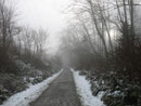
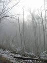
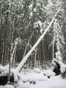
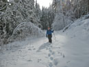
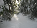
It was very misty when we began. We chose the railroad grade over the Woody Trail. The trees are coated with moss and with the mist gave them an eerie feel. There was snow along the side but the grade was bare dirt. At about 2 1/4 miles we reached the start of the Greg Ball Trail. Since my previous visit a nice trailhead board has been put in place. It includes info on Greg Ball.
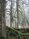
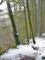
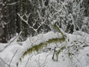
From here it is another 2 1/2 miles to the lake. The new trail is very nice. It generally follows the NF Wallace River to the lake. Much of the time it is out of sight and sound but not too far from the river. It is never steep as it finds gullies to avoid steeper slopes. There are a number of flat areas on the climb to the lake. There was a little snow on the trail at the start and it slowly grew deeper as we ascended. A number of trees have fallen in the far and near past creating openings in the forest. In these openings the snow depth would rise and fall again as we reentered deep forest.
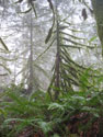
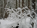
Snow on moss covered trees and stumps were quite beautiful. In many ways this trail looks better under a little snow than in the middle of summer. There was only one fresh set of footprints in the snow. That and one pair of dog prints. We soon met a woman and dog heading down. She said she saw what looked like two coyotes. That was enough reason for her to call it a day.
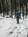
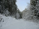
Just past the 1 1/2 mile mark the footprints turned around. Canine prints continued along the trail for quite a bit longer. Unless her dog ran far ahead we were tailing the coyotes. We came out of the forest and onto a logging road. No signs of any recent trucks on the road. The snow was soft and knee deep here. The sun was now burning through and we had shadows.
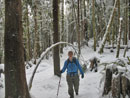
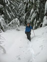
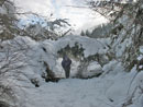
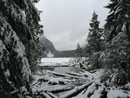
A short bit of trail breaking on the road and we reached the old road leading to the lake. The sign said we had .60 miles to go. With the deep snow it began to look like the loop was not a good idea. Much of the route from the lake to the falls is on new road that has not tree cover. The snow was sure to be at least knee deep. Once back in the forest the snow depth dropped significantly. There was still plenty of snow but trail breaking was not very hard.
Just before we reached the lake we met a lone hiker coming towards us. He was hiking the loop with no snowshoes and trail runners. That seemed to be a monumental task. It turned out that he had followed a group of snowshoers from the falls to the lake. At the outlet we met them. They were young kids out for an adventure. We pointed out the way to the Greg Ball Trail as they looked at the map and debated.
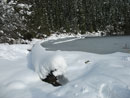
Now we had a choice to make. Follow the snowshoe trench over to the falls or head around to the far side of the lake. The benefit of the lake was that the far side was bathed in sunshine. We chose to hike the half mile around the lake. There were no recent tracks as we headed on. This section starts in forest but the snow was a lot deeper than I expected. It was more than knee deep in places Knee deep for me but much deeper for Kim.
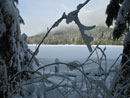
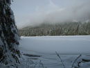
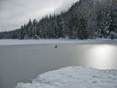
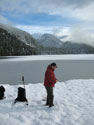
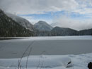
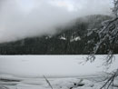
We made slow and steady progress around the lake. As the day warmed snow began to fall from the trees. Snow fell on me several times. It fell on Kim several dozen times. She seemed to attract falling snow. Heading around the lake the falling bombs fell faster and longer. Nothing like some freezing snow down your neck. At the far end of the lake is the inlet stream. This is the one opening in the thick brush that allows access to Pebble Beach. I hoped the lake would be low enough to leave the beach uncovered.
I slogged down the snow covered creek bed dropping under a low log and popped out at the beach. It looked much like summer but with all the gravel under a layer of snow. Kim arrived a few minutes later. There were clouds but for the most part we were in the sun. It would not last too much longer as the low sun was not far from dropping behind the ridge. It was cold but with no wind and a little sun it was not bad at all.
It took us four hours to cover 5 1/2 miles. The first two miles went fast but the snow really slowed us down farther along. We managed to spend half an hour but had to get moving to make it back before dark. It was much easier to hike back along the lake as we now had foot steps to follow. Some of them were deeper than Kim's legs. When we reached the old road to the lake I was very surprised to see snowshoe prints heading down. They were only heading down. Some forty years ago it was possible to drive all the way to the lake. Since then the road has been gated.
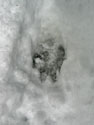
I don't even know exactly where it comes out. Why did someone snowshoe down it? Was it the four guys we had seen earlier? We continued hiking back to the outlet. Our footprints here had tracks in them. They were not deer. Too small to be bear. Too big to be much else. We had no idea what had very recently passed by. Back at the outlet we found that there were snowshoe tracks heading back to the Greg Ball Trail. Where did two sets of snowshoers come from?
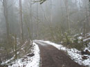
Now we just had to follow the tracks back down. The farther down we went the slushier the snow became. It was slick but I was glad the trail was so gentle. We stopped for some photos but mostly kept up a steady pace. Once back on the railroad grade the slush was gone and we had good footing the rest of the way. It was now after 4:00 PM and closing in on sunset. I was a little surprised to see one runner heading up then a single hiker with two dogs. They would definitely be out after dark.
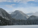
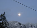
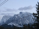
By the official sunset we were back on the powerline corridor. It was now clear enough to see Mts. Baring, Index, and Persis. We also saw the near full moon above. A last short hike and we were back in the lot. This was a full day of hiking and postholing in the snow. We had dense mist, slivers of sun and bright blue sky. As we were leaving the lake a short snow shower even hit us.
This is a very nice winter trip as 11 miles is a good leg stretcher. We had about 1800' of elevation gain counting a few ups and downs. Most winters there is very little snow. This year we did have snow though we managed without snowshoes. As usual the crowds are a small fraction of those found on the shorter falls trail. I had good weather, good photographing, and good company. What more could I ask for?
Kim's nwhikers report is here: Nwhikers Trip Report
Click on thumbnails to get larger pictures.
Trips - 2008
Home
It was very misty when we began. We chose the railroad grade over the Woody Trail. The trees are coated with moss and with the mist gave them an eerie feel. There was snow along the side but the grade was bare dirt. At about 2 1/4 miles we reached the start of the Greg Ball Trail. Since my previous visit a nice trailhead board has been put in place. It includes info on Greg Ball.
From here it is another 2 1/2 miles to the lake. The new trail is very nice. It generally follows the NF Wallace River to the lake. Much of the time it is out of sight and sound but not too far from the river. It is never steep as it finds gullies to avoid steeper slopes. There are a number of flat areas on the climb to the lake. There was a little snow on the trail at the start and it slowly grew deeper as we ascended. A number of trees have fallen in the far and near past creating openings in the forest. In these openings the snow depth would rise and fall again as we reentered deep forest.
Snow on moss covered trees and stumps were quite beautiful. In many ways this trail looks better under a little snow than in the middle of summer. There was only one fresh set of footprints in the snow. That and one pair of dog prints. We soon met a woman and dog heading down. She said she saw what looked like two coyotes. That was enough reason for her to call it a day.
Just past the 1 1/2 mile mark the footprints turned around. Canine prints continued along the trail for quite a bit longer. Unless her dog ran far ahead we were tailing the coyotes. We came out of the forest and onto a logging road. No signs of any recent trucks on the road. The snow was soft and knee deep here. The sun was now burning through and we had shadows.
A short bit of trail breaking on the road and we reached the old road leading to the lake. The sign said we had .60 miles to go. With the deep snow it began to look like the loop was not a good idea. Much of the route from the lake to the falls is on new road that has not tree cover. The snow was sure to be at least knee deep. Once back in the forest the snow depth dropped significantly. There was still plenty of snow but trail breaking was not very hard.
Just before we reached the lake we met a lone hiker coming towards us. He was hiking the loop with no snowshoes and trail runners. That seemed to be a monumental task. It turned out that he had followed a group of snowshoers from the falls to the lake. At the outlet we met them. They were young kids out for an adventure. We pointed out the way to the Greg Ball Trail as they looked at the map and debated.
Now we had a choice to make. Follow the snowshoe trench over to the falls or head around to the far side of the lake. The benefit of the lake was that the far side was bathed in sunshine. We chose to hike the half mile around the lake. There were no recent tracks as we headed on. This section starts in forest but the snow was a lot deeper than I expected. It was more than knee deep in places Knee deep for me but much deeper for Kim.
We made slow and steady progress around the lake. As the day warmed snow began to fall from the trees. Snow fell on me several times. It fell on Kim several dozen times. She seemed to attract falling snow. Heading around the lake the falling bombs fell faster and longer. Nothing like some freezing snow down your neck. At the far end of the lake is the inlet stream. This is the one opening in the thick brush that allows access to Pebble Beach. I hoped the lake would be low enough to leave the beach uncovered.
I slogged down the snow covered creek bed dropping under a low log and popped out at the beach. It looked much like summer but with all the gravel under a layer of snow. Kim arrived a few minutes later. There were clouds but for the most part we were in the sun. It would not last too much longer as the low sun was not far from dropping behind the ridge. It was cold but with no wind and a little sun it was not bad at all.
It took us four hours to cover 5 1/2 miles. The first two miles went fast but the snow really slowed us down farther along. We managed to spend half an hour but had to get moving to make it back before dark. It was much easier to hike back along the lake as we now had foot steps to follow. Some of them were deeper than Kim's legs. When we reached the old road to the lake I was very surprised to see snowshoe prints heading down. They were only heading down. Some forty years ago it was possible to drive all the way to the lake. Since then the road has been gated.
I don't even know exactly where it comes out. Why did someone snowshoe down it? Was it the four guys we had seen earlier? We continued hiking back to the outlet. Our footprints here had tracks in them. They were not deer. Too small to be bear. Too big to be much else. We had no idea what had very recently passed by. Back at the outlet we found that there were snowshoe tracks heading back to the Greg Ball Trail. Where did two sets of snowshoers come from?
Now we just had to follow the tracks back down. The farther down we went the slushier the snow became. It was slick but I was glad the trail was so gentle. We stopped for some photos but mostly kept up a steady pace. Once back on the railroad grade the slush was gone and we had good footing the rest of the way. It was now after 4:00 PM and closing in on sunset. I was a little surprised to see one runner heading up then a single hiker with two dogs. They would definitely be out after dark.
By the official sunset we were back on the powerline corridor. It was now clear enough to see Mts. Baring, Index, and Persis. We also saw the near full moon above. A last short hike and we were back in the lot. This was a full day of hiking and postholing in the snow. We had dense mist, slivers of sun and bright blue sky. As we were leaving the lake a short snow shower even hit us.
This is a very nice winter trip as 11 miles is a good leg stretcher. We had about 1800' of elevation gain counting a few ups and downs. Most winters there is very little snow. This year we did have snow though we managed without snowshoes. As usual the crowds are a small fraction of those found on the shorter falls trail. I had good weather, good photographing, and good company. What more could I ask for?
Kim's nwhikers report is here: Nwhikers Trip Report
At The Start |
Misty Mossy |
More Moss |
Railroad Grade |
Foggy Haze |
Snowier |
Snow Covered |
Arch |

Wintery |
Falling |
Moss & Snow |
Frozen On |
Logging Road |
Shadows! |
Framed Lake |
Frozen Lake |
Deeper Snow |
Untracked Snow |
Sun On Ice |
Pebble Beach |
Log Bench |
Small Peak |
View Down Lake |
Lake Inlet |
Paw Print |
Low Cloud |
Outlet View |
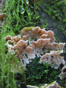
Fungus |
Moon Rise |
Index |
Trips - 2008
Home