6-07-09
Yesterday I
drove 240 miles and
attended a wedding. I did not get home until 9:45 pm. I wanted a short
drive for the day's hike. I chose a hike from Footsore 2 that
I
had thought about for more than a decade. It was time to do some
exploring. In the 1977 book the road was open as far as one could
drive. There have not been many reports so I did not have much to go
on. One 2001 report mentioned a gate near Mud Lake, 2 1/2 miles in. The
other more recent report mentioned an 18 mile hike to the old lookout
site. I was not sure what I would find.
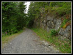
To get there, drive Highway 2 east over the bridge into Sultan. At the first light turn right. In one mile there is a "T". Go right on Ben Howard Road for exactly one mile. The gated road is on your left. Room for about three cars without blocking the gate. I arrived to find the gate (elevation 200') locked and a long walk ahead of me. It was only 43 miles from my home in North Seattle. I was not on the road very early and it was 9:45 when I started.
Since I did not do the usual planning for a new trip I had only the book and a hard to read map to go on. The ink on my printer picked this day to run out of one color half way across the page. Best of all, I managed to leave the book and map on the table at home. I was really on my own now. I knew there were numerous old spurs along the route. I just hoped the main one would be the most used and I could find my way.
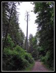
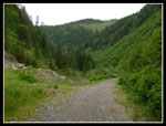
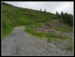
A short way up the gated road I saw why this gate will never be unlocked again. There is a cell phone tower right along the road. After a short climb the road is very gentle for a long way. This trip was back end loaded for elevation gain. It did allow for fast hiking at first. It also would be ideal for an easy mountain bike ride. A half bike half hike trip would be much easier if going all 18 miles round trip to the old lookout site.
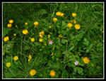
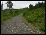
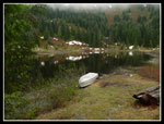
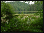
There are lots of flowers along the road. Yellow buttercup like flowers line much of the route. Some pink flowers and daisies are also along the lower route. The varieties changed as I gained elevation. About a mile in I was very surprised to see two jeeps heading out. Some folks have gate keys. I don't know where they had been. They were one of only two groups I saw all day. The trick is to always follow the most used road. There were several well used side roads but they had a little grass in the middle. The real route has no grass. My first mileage marker was at 2 1/2 miles. Mud Lake is just beyond. The lake may be a mud puddle in mid summer but it's a nice sized lake now.
There were cattails along the edge and some lily pads too. They had bright yellow flowers I had not seen before. After the lake there was a 3 mile marker. The grade is very flat through here. I gained 400' in the first 2 1/2 miles and 300 more in the next 2 1/4 miles. Finally at about 4 3/4 miles the route begins to climb. This would be a good spot to stash a mountain bike. The climb is steep at first then moderates a little. I calculated that I still had 2100' to gain in the last 3 1/4 miles.
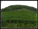
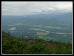
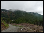
The route climbs into a narrow valley with a forested bump on the left and the bulk of the mountains on the right. Beyond there views began to open up. I could see down to the Skykomish Valley. The peaks of the Mountain Loop from Pilchuck to Big Four should have been on view but All I had were thick clouds. The road swichbacked to the right and entered a big clear cut. No trees but lots of green covering the ground. Each creek had a greenbelt of big trees on each side. I walked from open to forest to open a number of times.
There was another and final mile marker on a tree at 6 miles (2 hours) as the views first began. At about 7 miles I faced a dilemma. I came to a junction. Straight ahead on a flat road or climbing steeply to the left. If I had a map I would have known which road was correct. They were both well used and the road to the left might be just a little bit better. I was at about 2200' with 850' to go to Airplane lake in just 1 mile. That's pretty steep for a road. I debated and chose the steeper road.
It was plenty steep. I climbed up with a few short switchbacks. It just didn't feel right. I began to think it was just a road to log the trees up to the ridge. After more than half a mile and 550' of gain I came to another junction. One road down, one up to the right and the main road straight ahead and up. Now I was pretty sure this was the wrong route. If I kept going up to 3050' and didn't find Airplane Lake I would not have time and energy to take the other route. I turned around and headed down.
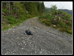
At the junction I took the other route. The road to this point could be driven by any car with above average ground clearance. There were a few small washouts but none very deep or long. The upper road has a few newer washouts that would be a problem. Only one would stop a truck and that one could be crossed with a little shoveling of dirt. No matter the road is gated and few will ever try to drive it again. The flat section ended abruptly and the road really began to climb. Another junction with one road heading down. Not for me. A few old spurs heading off. After an especially steep grade I came to yet another junction.
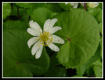
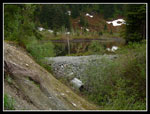
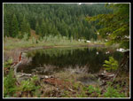
The left road was newer. The right one looked old and little used. I chose the right fork. I had seen lots of bunchberry lower and now I came to patches of marsh marigolds and violets. Lots of color. My altimeter was reading over 3000' and I was afraid I was not going to find the darn lake. Low and behold, off to the right through the trees was water. The outlet looks like it had blown out. Not much vegetation in the creek bed. A new culvert was in place with a loads of gravel around it. A gravel road was built recently to reach the outlet. I took the old dirt road down to the outlet, crossed it and went to the lake shore.
Airplane Lake is not very large. The hillside behind is forest and berry bushes. It would be very colorful in the fall. The ridge top was mostly in the clouds. It's just a mile from the lake to the lookout site with 500' of gain. I thought the road went around the right side of the lake but I was not sure (It does). The main gravel road goes up steeply to the left of the lake. I did see a dirt road/trail going to the right. It was still mostly snow covered. and a bit overgrown. That was the first snow I came to. There was some higher on the ridge top. The bugs were thick at the lake and my stay was short. It was almost 2:00 pm. The ridge was in clouds. I was not sure of the correct route to the old lookout site. I chose to head down.
The route down was fine but awfully long. A few years ago when plantar fasciitis was bedeviling me a nearly 18 mile road walk would have killed my feet. This day they were tired but not painful. On the way down I met three motorcycles with five passengers. They were friendly and courteous. They passed me again on their way out. I only took one break on the eight miles coming down. At Mud Lake I had some food and sat for a minute. I head a loud crashing noise out on the lake. A moment later I heard it again. I had to stand up and take a look. I saw something far out on the lake creating a wake. I couldn't tell what it was. My new camera has a crazy 18x zoom so I took a few shots at maximum zoom. I think it was a beaver. The noise was its tail slapping on the water. It was either a beaver or otter.
After that it was just another 2 1/2 miles of mind numbing walking. I was very glad to see my car again. It is 16 miles with 2950' of gain to Airplane Lake. 18 miles with 3500' to the lookout site. With my detour my day ended up being about 17 1/2 miles with 3600'. Most folks I know do not like hiking old logging roads. I can understand. Still, they go to many lakes and peaks and provide amazing solitude. I have done Roads to Rattlesnake Mountain, Calligan Lake, and now this one so far this year. There is a lot to be said for getting away from the crowds.
Click on thumbnails to get larger pictures.
Trips - 2009
Home
To get there, drive Highway 2 east over the bridge into Sultan. At the first light turn right. In one mile there is a "T". Go right on Ben Howard Road for exactly one mile. The gated road is on your left. Room for about three cars without blocking the gate. I arrived to find the gate (elevation 200') locked and a long walk ahead of me. It was only 43 miles from my home in North Seattle. I was not on the road very early and it was 9:45 when I started.
Since I did not do the usual planning for a new trip I had only the book and a hard to read map to go on. The ink on my printer picked this day to run out of one color half way across the page. Best of all, I managed to leave the book and map on the table at home. I was really on my own now. I knew there were numerous old spurs along the route. I just hoped the main one would be the most used and I could find my way.
A short way up the gated road I saw why this gate will never be unlocked again. There is a cell phone tower right along the road. After a short climb the road is very gentle for a long way. This trip was back end loaded for elevation gain. It did allow for fast hiking at first. It also would be ideal for an easy mountain bike ride. A half bike half hike trip would be much easier if going all 18 miles round trip to the old lookout site.
There are lots of flowers along the road. Yellow buttercup like flowers line much of the route. Some pink flowers and daisies are also along the lower route. The varieties changed as I gained elevation. About a mile in I was very surprised to see two jeeps heading out. Some folks have gate keys. I don't know where they had been. They were one of only two groups I saw all day. The trick is to always follow the most used road. There were several well used side roads but they had a little grass in the middle. The real route has no grass. My first mileage marker was at 2 1/2 miles. Mud Lake is just beyond. The lake may be a mud puddle in mid summer but it's a nice sized lake now.
There were cattails along the edge and some lily pads too. They had bright yellow flowers I had not seen before. After the lake there was a 3 mile marker. The grade is very flat through here. I gained 400' in the first 2 1/2 miles and 300 more in the next 2 1/4 miles. Finally at about 4 3/4 miles the route begins to climb. This would be a good spot to stash a mountain bike. The climb is steep at first then moderates a little. I calculated that I still had 2100' to gain in the last 3 1/4 miles.
The route climbs into a narrow valley with a forested bump on the left and the bulk of the mountains on the right. Beyond there views began to open up. I could see down to the Skykomish Valley. The peaks of the Mountain Loop from Pilchuck to Big Four should have been on view but All I had were thick clouds. The road swichbacked to the right and entered a big clear cut. No trees but lots of green covering the ground. Each creek had a greenbelt of big trees on each side. I walked from open to forest to open a number of times.
There was another and final mile marker on a tree at 6 miles (2 hours) as the views first began. At about 7 miles I faced a dilemma. I came to a junction. Straight ahead on a flat road or climbing steeply to the left. If I had a map I would have known which road was correct. They were both well used and the road to the left might be just a little bit better. I was at about 2200' with 850' to go to Airplane lake in just 1 mile. That's pretty steep for a road. I debated and chose the steeper road.
It was plenty steep. I climbed up with a few short switchbacks. It just didn't feel right. I began to think it was just a road to log the trees up to the ridge. After more than half a mile and 550' of gain I came to another junction. One road down, one up to the right and the main road straight ahead and up. Now I was pretty sure this was the wrong route. If I kept going up to 3050' and didn't find Airplane Lake I would not have time and energy to take the other route. I turned around and headed down.
At the junction I took the other route. The road to this point could be driven by any car with above average ground clearance. There were a few small washouts but none very deep or long. The upper road has a few newer washouts that would be a problem. Only one would stop a truck and that one could be crossed with a little shoveling of dirt. No matter the road is gated and few will ever try to drive it again. The flat section ended abruptly and the road really began to climb. Another junction with one road heading down. Not for me. A few old spurs heading off. After an especially steep grade I came to yet another junction.
The left road was newer. The right one looked old and little used. I chose the right fork. I had seen lots of bunchberry lower and now I came to patches of marsh marigolds and violets. Lots of color. My altimeter was reading over 3000' and I was afraid I was not going to find the darn lake. Low and behold, off to the right through the trees was water. The outlet looks like it had blown out. Not much vegetation in the creek bed. A new culvert was in place with a loads of gravel around it. A gravel road was built recently to reach the outlet. I took the old dirt road down to the outlet, crossed it and went to the lake shore.
Airplane Lake is not very large. The hillside behind is forest and berry bushes. It would be very colorful in the fall. The ridge top was mostly in the clouds. It's just a mile from the lake to the lookout site with 500' of gain. I thought the road went around the right side of the lake but I was not sure (It does). The main gravel road goes up steeply to the left of the lake. I did see a dirt road/trail going to the right. It was still mostly snow covered. and a bit overgrown. That was the first snow I came to. There was some higher on the ridge top. The bugs were thick at the lake and my stay was short. It was almost 2:00 pm. The ridge was in clouds. I was not sure of the correct route to the old lookout site. I chose to head down.
The route down was fine but awfully long. A few years ago when plantar fasciitis was bedeviling me a nearly 18 mile road walk would have killed my feet. This day they were tired but not painful. On the way down I met three motorcycles with five passengers. They were friendly and courteous. They passed me again on their way out. I only took one break on the eight miles coming down. At Mud Lake I had some food and sat for a minute. I head a loud crashing noise out on the lake. A moment later I heard it again. I had to stand up and take a look. I saw something far out on the lake creating a wake. I couldn't tell what it was. My new camera has a crazy 18x zoom so I took a few shots at maximum zoom. I think it was a beaver. The noise was its tail slapping on the water. It was either a beaver or otter.
After that it was just another 2 1/2 miles of mind numbing walking. I was very glad to see my car again. It is 16 miles with 2950' of gain to Airplane Lake. 18 miles with 3500' to the lookout site. With my detour my day ended up being about 17 1/2 miles with 3600'. Most folks I know do not like hiking old logging roads. I can understand. Still, they go to many lakes and peaks and provide amazing solitude. I have done Roads to Rattlesnake Mountain, Calligan Lake, and now this one so far this year. There is a lot to be said for getting away from the crowds.
 Lots of Color |
 Cell Tower |
 Green Border |
 Big Bridge |
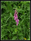 Foxglove |
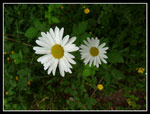 Daisies |
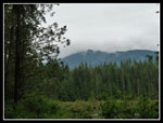 Cloudy Ridge |
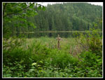 Mud Lake |
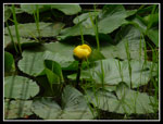 Yellow Marsh Flower |
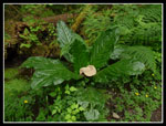 Skunk Cabbage |
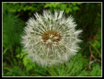 Dandelion Puffball |
 Blasted Wall |
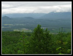 First View Of Valley |
 Narrow Valley |
 Old & New Forest |
 Steeper & Open |
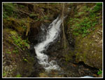 Waterfall |
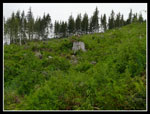 Springboard Stump |
 Bunchberries |
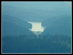 Spada Lake? |
 Spada Across Valley |
 Open Slope |
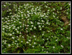
 Marsh Marigold |
 Airplane Lake |
 Lake Shore |
 Lake Reflection |
 Ridge To Lookout |
 Last Junction |
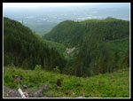 Narrow Valley Below |
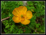 Buttercup Like Flower |
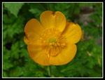 Even Closer |
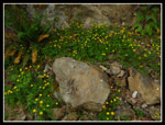 Rock Garden |
 Back At Mud Lake |
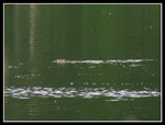 Beaver? |
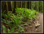 Bright Ferns |
Trips - 2009
Home