12-27-09
Small Si
After a scary
run down the Wallace Lake trail in high winds with branches breaking
off the day before I chose two small summits. The watch towers of the
Snoqualmie River Valley. Those colossal peaks Small Si and Ceder Butt.
Some know them as Little Si and Cedar Butte but hey you have to go with
what the US Geological Survey stamps on their summit benchmarks. I
decided it was time to get photographic proof of their real names. I
was not all that early and the Small Si lot was about 1/3 full at 9:10
am. There was some wind at the trailhead but as I had hoped it
dissipated when I entered forest. I had done Small Si a number of times
via the old trail but only a few times since the new one opened.
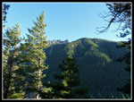
The trail is easy enough as it climbs then continues mostly flat until reaching the peak. It was in the mid 30s with yet another day of blue sky. No climbers out yet. I passed several groups already on their way back. The trail goes more than half way around the peak before it begins to climb. on the way I looked in vain for the old cabin above the trail. I think it is gone now. The climbing is mostly very gentle until the old trail is met and then it climbs a little more steeply.
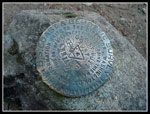
With a few photo stops I neared the summit in just under one hour. I could hear the wind as I climbed and it was blowing pretty hard on top. I bundled up with several more layers. I remembered that there were two benchmarks on top. I looked all around the summit and found nothing. I climbed down the east side a ways and found.... nothing. Where were they? I headed back to the summit and found one. A few minutes later I found the other one. I thought only one had "Small Si" on it but both do.
The wind was too strong to spend much time on the summit. Soon I was on my way down. I passed many more folks coming up as I descended. This is an excellent close in easy trail to a summit and is justifiably mobbed most days. When I returned to the trailhead all the parking spaces were full. Surprisingly, the newer lot nearby was nearly empty. It was still only 11:15 and I had plenty of time to tackle another mighty peak. I was soon off to the Rattlesnake Lake area.
Ceder Butt
It took less than 15 minutes to drive to the Iron Horse State Park lot. The Rattlesnake Lake side of the road was packed with cars as always. The state park side was 3/4 empty. The route begins with a mile of flat walking along the old Chicago, Milwaukee, & St. Paul railroad grade. The turn off for Ceder Butt is well marked. This too was once a very short and steep unofficial trail. It is now much longer and gentler.
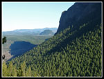
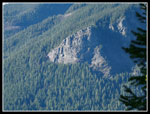
I climbed up to a junction. There was no sign. I knew that there was a trail that went to the Boxley Blowout overlook but I had not taken it before. The junction has a large trail heading right and a smaller one going left. I went right. This turned out to be the Boxley turn without the old sign. It is definitely longer and much more gentle than the old main trail. I expect most folks will now take this route. The Blowout is not much to see. Trees have grown up and now block any view of where the creek once blew out a dam and sent a wall of water down on folks below.
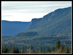
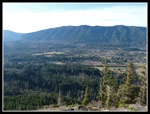
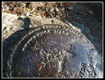
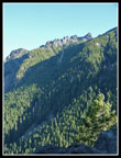
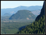
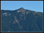
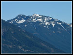
I met the old trail at the old saddle junction and headed up the last 300' to the top. I was protected from the wind until nearly on top. Up there is was blowing hard and cold. Again I had to stop just before the top to bundle up. I nearly caught a couple at the pass and met them at the top. I snapped a few shots of the "Ceder Butt" benchmark and peaks across the valley. Trees have grown a lot since my last visit and views may be short lived. Si, Teneriffe, Green, and South Bessemer were clearly seen.
My stay was short. Soon I was heading down. It took about the same amount of time to summit the Butt as Small Si. On the trail down I passed 4 or 5 groups coming up. That is more than I have ever seen on the trail. Not popular but also not unknown any longer. I had a tailwind on the railroad grade so it was not as cold as the hike in. It was only 1:30 when I reached my car. Not a bad day. Two mighty summits with 9 miles and 2200' of elevation gain. It was a little windy but nothing like the day before.
Click on thumbnails to get larger pictures.
Trips - 2009
Home
The trail is easy enough as it climbs then continues mostly flat until reaching the peak. It was in the mid 30s with yet another day of blue sky. No climbers out yet. I passed several groups already on their way back. The trail goes more than half way around the peak before it begins to climb. on the way I looked in vain for the old cabin above the trail. I think it is gone now. The climbing is mostly very gentle until the old trail is met and then it climbs a little more steeply.
With a few photo stops I neared the summit in just under one hour. I could hear the wind as I climbed and it was blowing pretty hard on top. I bundled up with several more layers. I remembered that there were two benchmarks on top. I looked all around the summit and found nothing. I climbed down the east side a ways and found.... nothing. Where were they? I headed back to the summit and found one. A few minutes later I found the other one. I thought only one had "Small Si" on it but both do.
The wind was too strong to spend much time on the summit. Soon I was on my way down. I passed many more folks coming up as I descended. This is an excellent close in easy trail to a summit and is justifiably mobbed most days. When I returned to the trailhead all the parking spaces were full. Surprisingly, the newer lot nearby was nearly empty. It was still only 11:15 and I had plenty of time to tackle another mighty peak. I was soon off to the Rattlesnake Lake area.
Ceder Butt
It took less than 15 minutes to drive to the Iron Horse State Park lot. The Rattlesnake Lake side of the road was packed with cars as always. The state park side was 3/4 empty. The route begins with a mile of flat walking along the old Chicago, Milwaukee, & St. Paul railroad grade. The turn off for Ceder Butt is well marked. This too was once a very short and steep unofficial trail. It is now much longer and gentler.
I climbed up to a junction. There was no sign. I knew that there was a trail that went to the Boxley Blowout overlook but I had not taken it before. The junction has a large trail heading right and a smaller one going left. I went right. This turned out to be the Boxley turn without the old sign. It is definitely longer and much more gentle than the old main trail. I expect most folks will now take this route. The Blowout is not much to see. Trees have grown up and now block any view of where the creek once blew out a dam and sent a wall of water down on folks below.
I met the old trail at the old saddle junction and headed up the last 300' to the top. I was protected from the wind until nearly on top. Up there is was blowing hard and cold. Again I had to stop just before the top to bundle up. I nearly caught a couple at the pass and met them at the top. I snapped a few shots of the "Ceder Butt" benchmark and peaks across the valley. Trees have grown a lot since my last visit and views may be short lived. Si, Teneriffe, Green, and South Bessemer were clearly seen.
My stay was short. Soon I was heading down. It took about the same amount of time to summit the Butt as Small Si. On the trail down I passed 4 or 5 groups coming up. That is more than I have ever seen on the trail. Not popular but also not unknown any longer. I had a tailwind on the railroad grade so it was not as cold as the hike in. It was only 1:30 when I reached my car. Not a bad day. Two mighty summits with 9 miles and 2200' of elevation gain. It was a little windy but nothing like the day before.
 Rattlesnake Ledge |
 Mt. Si Summit |
 Near Small Si Summit |
 Rattlesnake Mountain |
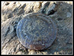 First Small Si Benchmark |
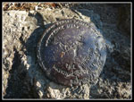 Second Si Benchmark |
 Close Up |
 Big Si From Small Si |
 Fuller Mt. Close Up |
 Fuller Mt. |
 Ceder Butt Benchmark |
 Mt. Teneriffe |
 South Bessemer Mt. |
 Ledges Close Up |
 Boxley Blowout Overlook |
Trips - 2009
Home