4-05-09
A sunny day
after a week of big snow storms in the mountains. Avalanche danger was
high. David and his friend Beth were heading up north to Welcome Pass
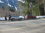
and Suzanne, Barry, and I joined them. We were out of Seattle by 7:00
am. It's along drive to the north side of Mt. Baker. We met David and
Beth at the Glacier Ranger Station just after 9:00 am. From there we
drove east missing the start just as we did on our February
2006
snowshoe trip. That was a beautiful day and I was very ready to come
back. The start is a plowed pull out on the south side of the road
about 1/3 mile before the DOT maintenance facility. We turned around at
the DOT facility and parked at 2000'. By 9:45 we were on our way.
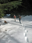
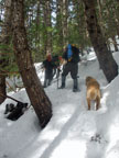
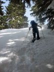
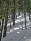
The road to the summer trailhead was buried and hard to see from the road. Two steps was enough to know we needed snowshoes immediately. Many feet of snow fell the preceding week and it was deep, wet, and heavy. We sank in even though it was shady and cold. We walked the road to the summer trailhead and found the trail log. The last sign in was in mid February. There were no snowshoe or ski tracks. I hoped we would have some tracks to help with route finding.
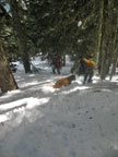
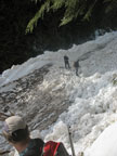
The summer trail begins as an old road. It's wide and climbs gently. Soon we came to the creek crossing. This is the crux of the trip in the winter. The creek gully drains the slopes high above. It's only about 100' across but in high avalanche danger times it can be dangerous. It was early and still pretty cold. We had no trouble getting across. A little more road walking and the route was suddenly filled with small trees. We could not see any trail heading uphill but chose to start climbing. Up to the end of the road we gained 900'. We still had 2300' to go in less than 1 1/2 miles.
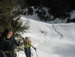
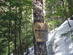
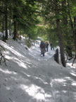
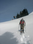
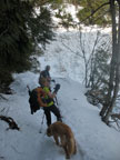
The snow was not too bad on the road section. It was much worse as we climbed. Sink and slide back. Lift your leg high to get above the snow, sink, and slide. It was not possible to make much progress without constant lead changes. A few hundred feet up from the road we ran into the trail. Just to the left was the Wilderness Boundary sign. We were able to follow the trail for awhile but lost it again. The slope began to follow a defined ridge. It went from steep to very steep sections followed by just steep again. With the soft snow a fall would not have gone too far.
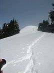
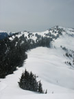
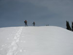
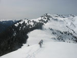
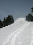
Time moved rapidly but our progress was glacial. The whole climb was in forest. This and the ridge minimized avalanche danger but afforded almost no views. At one point a few hundred feet below the ridge a small open spot afforded some views. That last few hundred feet was the worst. The snow was deeper and even less consolidated. Going straight up was nearly impossible in places and we mostly made short switchbacks. Even with blue sky showing through to highlight the ridge top just above us we had to slowly slog on. At long last we topped out just above 5200' Welcome Pass. It took us 4 1/4 hours to climb just over 3 miles. More than half that distance was on a smooth road. We were all beat.
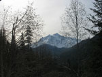
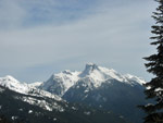
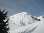
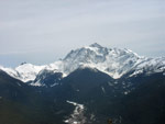
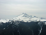
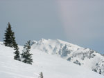
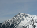
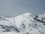
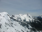
We could see the pass and the ridge to the west. We could see north to Tomyhoi and peaks in Canada. We could not see to the south because of the wall of trees. We had to keep going to get the really good views. The last climb was short and steep. As we climbed Baker and Shuksan came into view. There was now a layer of high clouds turning the sky a light white. It did take away contrast to the mountains. Barry and Suzanne led the way up and David, Beth, and I followed. At the top of the bump on the ridge the views really improve. We added Goat, Ruth, Sefrit and others to the field of view.
We sat and ate and photographed the mountains all around us. On my earlier trip we continued up the ridge to the high point above Yellow Aster tarns. This time we lacked enough time. It was already past 2:30 when we headed down. The drop to the pass was fast and easy. The slog down the slope was a little slick and the snow broke away on some steps but it was much easier than the ascent. Barry and Suzanne were down to the road in just under one hour. Within 1:15 we were all down to there. Now it was just a road slog back to the car. Or so we thought.
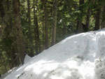
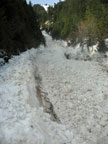
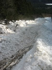
Barry and Suzanne took off again and I didn't expect to see them until at least the summer trailhead. As I approached the creek I caught up with them. Wait a minute, something did not look right. Hoy cow! The whole creek gully avalanched while we were up high. All the way up and all the way down! It was not a snow slide. It was a violent blow out. Hundreds of icy balls up to 3 or 4 feet in diameter filled the gully. The avalanche scoured much of the snow out. We saw bare ground where there had been 5 feet of snow. The ice ball pile formed a wall we had to climb over. It was scary to imagine the power of that avalanche. Scary and more than a little sobering.
On the positive side, the avalanche originated high on the slope. One could cross it quickly if it was noticed mid way across. We also crossed early before the afternoon sun weakened the snow even more. We crossed quickly though it did not look like much snow was left above. After that it was just a snow slog back to the cars. We were all tired and glad to be back. It was a challenging day with some of the most difficult snow conditions I have snowshoed in. The views were every bit as good as I remembered. The trip down was easier than I had feared. It was an awful lot of work but it did make for quite and adventure.
Our nwhikers report with photos is here: Welcome Pass Report
Click on thumbnails to get larger pictures.
Trips - 2009
Home
The road to the summer trailhead was buried and hard to see from the road. Two steps was enough to know we needed snowshoes immediately. Many feet of snow fell the preceding week and it was deep, wet, and heavy. We sank in even though it was shady and cold. We walked the road to the summer trailhead and found the trail log. The last sign in was in mid February. There were no snowshoe or ski tracks. I hoped we would have some tracks to help with route finding.
The summer trail begins as an old road. It's wide and climbs gently. Soon we came to the creek crossing. This is the crux of the trip in the winter. The creek gully drains the slopes high above. It's only about 100' across but in high avalanche danger times it can be dangerous. It was early and still pretty cold. We had no trouble getting across. A little more road walking and the route was suddenly filled with small trees. We could not see any trail heading uphill but chose to start climbing. Up to the end of the road we gained 900'. We still had 2300' to go in less than 1 1/2 miles.
The snow was not too bad on the road section. It was much worse as we climbed. Sink and slide back. Lift your leg high to get above the snow, sink, and slide. It was not possible to make much progress without constant lead changes. A few hundred feet up from the road we ran into the trail. Just to the left was the Wilderness Boundary sign. We were able to follow the trail for awhile but lost it again. The slope began to follow a defined ridge. It went from steep to very steep sections followed by just steep again. With the soft snow a fall would not have gone too far.
Time moved rapidly but our progress was glacial. The whole climb was in forest. This and the ridge minimized avalanche danger but afforded almost no views. At one point a few hundred feet below the ridge a small open spot afforded some views. That last few hundred feet was the worst. The snow was deeper and even less consolidated. Going straight up was nearly impossible in places and we mostly made short switchbacks. Even with blue sky showing through to highlight the ridge top just above us we had to slowly slog on. At long last we topped out just above 5200' Welcome Pass. It took us 4 1/4 hours to climb just over 3 miles. More than half that distance was on a smooth road. We were all beat.
We could see the pass and the ridge to the west. We could see north to Tomyhoi and peaks in Canada. We could not see to the south because of the wall of trees. We had to keep going to get the really good views. The last climb was short and steep. As we climbed Baker and Shuksan came into view. There was now a layer of high clouds turning the sky a light white. It did take away contrast to the mountains. Barry and Suzanne led the way up and David, Beth, and I followed. At the top of the bump on the ridge the views really improve. We added Goat, Ruth, Sefrit and others to the field of view.
We sat and ate and photographed the mountains all around us. On my earlier trip we continued up the ridge to the high point above Yellow Aster tarns. This time we lacked enough time. It was already past 2:30 when we headed down. The drop to the pass was fast and easy. The slog down the slope was a little slick and the snow broke away on some steps but it was much easier than the ascent. Barry and Suzanne were down to the road in just under one hour. Within 1:15 we were all down to there. Now it was just a road slog back to the car. Or so we thought.
Barry and Suzanne took off again and I didn't expect to see them until at least the summer trailhead. As I approached the creek I caught up with them. Wait a minute, something did not look right. Hoy cow! The whole creek gully avalanched while we were up high. All the way up and all the way down! It was not a snow slide. It was a violent blow out. Hundreds of icy balls up to 3 or 4 feet in diameter filled the gully. The avalanche scoured much of the snow out. We saw bare ground where there had been 5 feet of snow. The ice ball pile formed a wall we had to climb over. It was scary to imagine the power of that avalanche. Scary and more than a little sobering.
On the positive side, the avalanche originated high on the slope. One could cross it quickly if it was noticed mid way across. We also crossed early before the afternoon sun weakened the snow even more. We crossed quickly though it did not look like much snow was left above. After that it was just a snow slog back to the cars. We were all tired and glad to be back. It was a challenging day with some of the most difficult snow conditions I have snowshoed in. The views were every bit as good as I remembered. The trip down was easier than I had feared. It was an awful lot of work but it did make for quite and adventure.
Our nwhikers report with photos is here: Welcome Pass Report
 Getting Ready To Go |
 Soft Snow |
 Shuksan View |
 Creek Pre Avalanche |
 Starting Uphill |
 Wilderness Boundary |
 Back On Trail |
 Mt. Sefrit View |
 Suzanne Near Ridge |
 View Northwest Of Pass |
 Last Push To Ridge |
 High Point Ahead |
 Welcome Pass Below |
 Mt. Shuksan |
 Approaching High Point |
 Mt. Baker |
 Goat Mountain |
 Tomyhoi Peak |
 Northwest Again |
 Farther Northwest |
 Heading Back To Pass |
 Dropping To Pass |
 Descending From Ridge |
 Steeper |
 David Descending |
 Creek Post Avalanche |
 Barry Crossing Rubble |
 Looking Up Gully |
 Looking Down Gully |
 David & Beth Crossing |
Trips - 2009
Home