7-03-10
I had plans to
hike up to a snow
covered lake in the Cascades but low clouds and rain had me changing my
mind. The lowlands looked to be much warmer and drier. I couldn't make
up my mind and it was already 9:30 am when I finally headed north to
Blanchard Mountain. This is a trip I usually do in the winter when I
want a snow free hike with a few thousand feet of elevation gain. I
cruised north on I-5 to exit 240 Alger. A left turn across the freeway
and another left onto Barrel Springs Road brought me to the signed dirt
road on the right for Blanchard Mountain. I went past the first
trailhead and parked at the upper one.
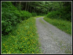
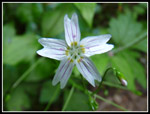
My visit earlier this year was clockwise and from the lower trailhead. This time I chose to go counter clockwise from the upper trailhead. A biker went up the road while I was getting ready followed by two horses. It was already 11:07 when I started out. I headed up the gravel road and soon passed the gate. As with every other old road I've hiked this spring the sides were lined with buttercups and spring beauty. This year has had a bumper crop of both. The horse riders soon passed me heading down. I would not see many other people for a long while. The day was mostly overcast but dry.
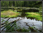
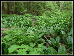
I left the road at the Alternate Incline Trail. I heard the pitter patter of what I thought was rain. It turned out to be needles falling from the trees. No need for rain gear. When I reached the Pacific Northwest Trail I turned right heading to Lizard Lake. The lake is only a few minutes away. The lake was about as full as it gets. I took a short break at the lake admiring the size of the skunk cabbage leaves near shore. They were bright yellow on my earlier visit. No yellow but the leaves are much larger now.
Back on my first visit to the lake I looked around for the supposed short cut route to Lily Lake. I followed a boot track that ended then scrambled up to a boulder field with trailer sized boulders. On following visits I did not look for the route. This time I thought it was time for a second look. From the big sign I ventured uphill and saw a track heading up from a campsite. That was the way I went last time. This time a little more searching found a narrow trail. Not an animal track but real tread. I followed this until I came to a junction. This looked a little familiar. I went right heading uphill.
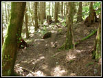
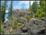
I soon recognized this as the trail from Lily Lake to North Butte. A few minutes later I arrived at the butte. Not much for views though there were some sun breaks. It was 12:30 and past time for lunch. There was enough wind to have me dig out my jacket. After a short summit stay I headed on down. A hundred vertical feet down I reached the saddle and stopped. I had not been to the top of Point 2280. It was not far and only 200 feet above. The forest is dark here with little underbrush and deep soft duff underfoot. Lots of rotting trees to clamber over. Fortunately I had my GPS as there are three rocky spots of similar elevation. Zero views as the whole summit area is in forest.
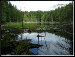
The GPS seemed to be pointing at the third one and I even found a benchmark listing Lily NO 1 and 1941. I was curious as to why the NO 1 and a little more searching found a second benchmark. This one just stated "Lily" though it is so marred that there many have been more there at one time. The map showed the ridge south to be gentle enough to drop right to the trail near the cut off to Lily Lake but I chose to backtrack to the North Butte Trail. From there it was an easy descent to Lily Lake.
Near the shore is a big patch of skunk cabbage with leaves up to three feet in length. The sweet "skunk" smell permeated the air. I did not go to the viewpoint at the lake outlet as I saw two other hikers just arriving there. More sun was breaking through as I reached the lake. A few minutes later I was at the junction. A right turn headed me on to Oyster Dome. Along the trail here is a great spring spot to view a sea of yellow skunk cabbage. Again, the yellow spathes were gone but the leaves were bright green.
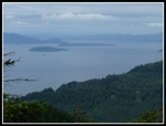
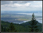
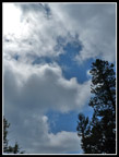
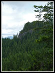
I headed down the trail and soon reached the unsigned junction with the trail up from Chuckanut Drive. Two hikers were here wondering what was up the trail I was hiking. Most Oyster Dome hikers have no idea about the rest of Blanchard Mountain. I arrived at the Dome to find the best viewpoints full of hikers. I managed a semi view and finished my lunch. Directly above me was a dividing line. To the north was blue sky and to the south was very dark gray. Sun and shade blew in and out. I also took the short tip over to the Oyster Dome high point. While in forest it does provide a view to the north and east over to North Butte.
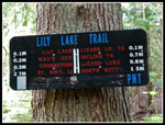
Now it was time to head on back. I retraced my track to the Lily Lake junction and a little way beyond on the PNT. The junction with the Lily Lake Trail is signed for Lizard Lake and Lily Lake but not signed for the Lily Lake Trail itself. The trail down is smooth and gentle with a few short uphill stretches. I met four hikers at the benches who were a little winded from the climb. That was it for people. I reached my car at about 3:20. In a little over 4 hours on the trail I traveled 9 miles with 2200' of gain. I hit 3 summits, visited 2 lakes and had the usual nice views from Oyster Dome. As usual, I saw very few people except between the Chuckanut Trail and Oyster Dome. It turned out to be a good choice for the day. Much better than hiking in wet snow to a gray cloudy lake.
Click on thumbnails to get larger pictures.
Trips - 2010
Home
My visit earlier this year was clockwise and from the lower trailhead. This time I chose to go counter clockwise from the upper trailhead. A biker went up the road while I was getting ready followed by two horses. It was already 11:07 when I started out. I headed up the gravel road and soon passed the gate. As with every other old road I've hiked this spring the sides were lined with buttercups and spring beauty. This year has had a bumper crop of both. The horse riders soon passed me heading down. I would not see many other people for a long while. The day was mostly overcast but dry.
I left the road at the Alternate Incline Trail. I heard the pitter patter of what I thought was rain. It turned out to be needles falling from the trees. No need for rain gear. When I reached the Pacific Northwest Trail I turned right heading to Lizard Lake. The lake is only a few minutes away. The lake was about as full as it gets. I took a short break at the lake admiring the size of the skunk cabbage leaves near shore. They were bright yellow on my earlier visit. No yellow but the leaves are much larger now.
Back on my first visit to the lake I looked around for the supposed short cut route to Lily Lake. I followed a boot track that ended then scrambled up to a boulder field with trailer sized boulders. On following visits I did not look for the route. This time I thought it was time for a second look. From the big sign I ventured uphill and saw a track heading up from a campsite. That was the way I went last time. This time a little more searching found a narrow trail. Not an animal track but real tread. I followed this until I came to a junction. This looked a little familiar. I went right heading uphill.
I soon recognized this as the trail from Lily Lake to North Butte. A few minutes later I arrived at the butte. Not much for views though there were some sun breaks. It was 12:30 and past time for lunch. There was enough wind to have me dig out my jacket. After a short summit stay I headed on down. A hundred vertical feet down I reached the saddle and stopped. I had not been to the top of Point 2280. It was not far and only 200 feet above. The forest is dark here with little underbrush and deep soft duff underfoot. Lots of rotting trees to clamber over. Fortunately I had my GPS as there are three rocky spots of similar elevation. Zero views as the whole summit area is in forest.
The GPS seemed to be pointing at the third one and I even found a benchmark listing Lily NO 1 and 1941. I was curious as to why the NO 1 and a little more searching found a second benchmark. This one just stated "Lily" though it is so marred that there many have been more there at one time. The map showed the ridge south to be gentle enough to drop right to the trail near the cut off to Lily Lake but I chose to backtrack to the North Butte Trail. From there it was an easy descent to Lily Lake.
Near the shore is a big patch of skunk cabbage with leaves up to three feet in length. The sweet "skunk" smell permeated the air. I did not go to the viewpoint at the lake outlet as I saw two other hikers just arriving there. More sun was breaking through as I reached the lake. A few minutes later I was at the junction. A right turn headed me on to Oyster Dome. Along the trail here is a great spring spot to view a sea of yellow skunk cabbage. Again, the yellow spathes were gone but the leaves were bright green.
I headed down the trail and soon reached the unsigned junction with the trail up from Chuckanut Drive. Two hikers were here wondering what was up the trail I was hiking. Most Oyster Dome hikers have no idea about the rest of Blanchard Mountain. I arrived at the Dome to find the best viewpoints full of hikers. I managed a semi view and finished my lunch. Directly above me was a dividing line. To the north was blue sky and to the south was very dark gray. Sun and shade blew in and out. I also took the short tip over to the Oyster Dome high point. While in forest it does provide a view to the north and east over to North Butte.
Now it was time to head on back. I retraced my track to the Lily Lake junction and a little way beyond on the PNT. The junction with the Lily Lake Trail is signed for Lizard Lake and Lily Lake but not signed for the Lily Lake Trail itself. The trail down is smooth and gentle with a few short uphill stretches. I met four hikers at the benches who were a little winded from the climb. That was it for people. I reached my car at about 3:20. In a little over 4 hours on the trail I traveled 9 miles with 2200' of gain. I hit 3 summits, visited 2 lakes and had the usual nice views from Oyster Dome. As usual, I saw very few people except between the Chuckanut Trail and Oyster Dome. It turned out to be a good choice for the day. Much better than hiking in wet snow to a gray cloudy lake.
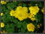 Buttercup Close Up |
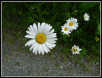 Daisies |
 Buttercup Border |
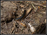 Little Guy |
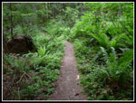 Alternate Incline Trail |
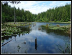 Lizard Lake |
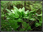 Skunk Cabbage Bush |
 Lizard - Lily Trail |
 North Butte Summit |
 North Butte View |
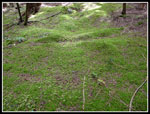 Mossy Ground |
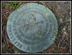 First Benchmark |
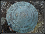 Second Benchmark |
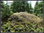 Summit of Pt. 2280 |
 More Moss |
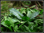 Biggest Skunk Cabbage |
 Lily Lake Color |
 Lily Lake |
 Spring Beauty |
 Oyster Dome View |
 White Meets Blue |
 North Butte |
 Skunk Cabbage Field |
 North Butt? |
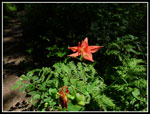 Columbine |
Trips - 2010
Home