6-04-11
I
first hiked up Mission Ridge in 1991 and again in 1992. A few years
later I hiked to the end of Devil's Gulch. The water was too high that
day and I did not complete the loop as planned. More than a decade
later I finally hiked up Mission Ridge, dropped to the creek, and
completed the loop. That was in 2005.
The road to the trailhead washed out several years ago and was only
repaired in October of last year. It was time for a return visit. This
is a long hike. 18 miles with 3800' of gain. There are great
wildflowers in the spring but the creek crossings can be hard at that
time. In mid summer it is just brutally hot. Janet joined me for this
death march. This would be by far the hardest hike since she had both
knees replaced only 14 months ago.
We met in Monroe at 6:30 am. It was another 106 miles to the trailhead. Traffic was not bad as we crossed Stevens Pass and on to Leavenworth and Cashmere. Per my 100 Hikes In The Alpine Lakes book, go .04 miles from the stop sign in town, turn left on Mission Creek Road, right at the "T" then left immediately after crossing the creek. At the end of pavement we turned left for a few miles to the trailhead. The old road is now part of the creek and the repair has moved it up the hillside a little. Hopefully this time it will not wash away again.
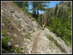
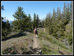
We arrived at the trailhead at 8:45 am and were on the trail at 8:55. This has been a wet and snowy spring and it really shows in the gulch. It is as wet and green as I have ever seen it. Most of my other visits have been in early May but this year I waited a month later for the snow to melt and the creek to subside, at least a little. I really liked hiking clockwise on my earlier loop. Get all the elevation out of the way in the cool morning. This time we went counter clockwise. With a high near 80 degrees we wanted to get in the three fords of Mission Creek before afternoon snow melt caused the creek to rise too much. It is 7 1/2 miles to the last crossing so it does take some time.
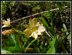
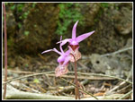
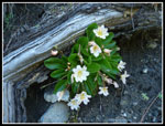
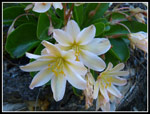
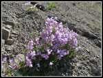
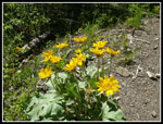
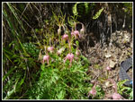
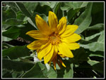
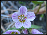
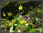
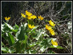
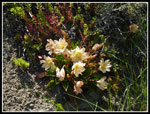
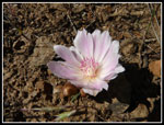
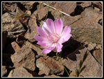
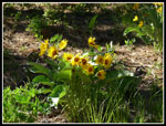
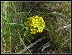
Wildflowers began immediately and never let up. Balsamroot, glacier lilies, trillium, and even the elusive Tweedy's lewisia are seen on the loop but we saw many more varieties. I can't recall nor name all the flowers we saw. Here is a short list: penstemon, scarlet gilia, balsamroot, trillium, old man's whiskers, Tweedy's lewisia, glacier lilies, bitterroot, calypso orchids, Indian paintbrush, lupine, wallflower, ballhead waterleaf, phlox, woodland star, mariposa lily, spring beauty, and more. It was a real riot of color. a whole lot more than I was expecting.
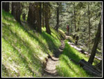
Although snow has been gone from the Gulch for some time there were many puddles of water. There must have been a lot of recent rain. It was shorts and short sleeves weather right from the start. We haven't had much of that his year. There were no cars in the lot so we had a head start if motorcycles were coming. These trails are open to motorcycles. I usually see a few and the riders have been extremely courteous on each and every occasion. The Gulch is also popular with mountain bikers. One can continue on the road to the trailhead then ride the trail all the way downhill to the car.
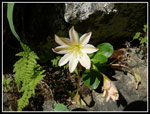
We made good time hiking but with quite a few photo stops. With the length of the hike and the possible dicey creek crossings we chose small light point and shoot cameras instead of heavier and much more expensive DSLRs. On my last visit I was surprised to find several Tweedy's lewisia in bloom above the trail. This time we found more than I remembered. They were mostly a little beyond their peak but still very nice. One big log is down across the trail. With our long legs we were just able to climb across. There were signs of a few motorcycles that have cut way around the tree. Hopefully it can be cut out before the reroute becomes a deep rut.
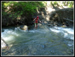
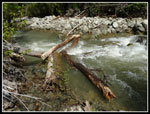
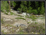
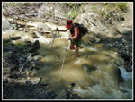
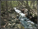
The first creek crossing was interesting. It was not all that wide and so was fast and deep. We are both 6' 2" or more and the water was above our knees. Janet brought sandals and I crossed in bare feet. With two poles for balance and leverage it was manageable. Now on the left side of the creek we climbed will above the water. The trail went from forest to open rock gardens. The best scarlet gilia was along here. Lots of balsamroot and penstemon too. At about the 5 mile mark we reached the second crossing. It looked like snow melt had raised the water a little since our first crossing. I chose to try crossing a narrow log. The water was so deep here my poles did not reach the creek bottom. I had to just wing it. Not easy but I made it across. Janet though another ford made better sense. She crossed with no problem.
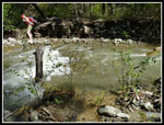
Back on the right side we found more rock gardens. Open slopes with more Tweedy's lewisia and other flowers growing in the rocky hillside. We now had better views across to Mission Ridge and up and down the valley. A few side creeks were easy rock hops. We came to a bigger side creek that required another ford. All these shoes off/shoes on drills took some time. At 7 miles we came to a creek that was just not big enough to be the main channel though at first we thought it might be. We were able to rock hop here. Finally at 7.6 miles was the final crossing. The fact that there were two big side creeks soon before that we had already crossed meant the final creek was not nearly as big as I had feared. It was flowing very fast but not too deep or wide. I managed to jump from a wet rock in the middle and Janet made a final ford.
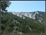
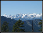
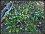
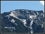
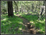
Now there were no more water crossings but also no more water sources. The final 10 1/2 miles are completely dry. Another benefit of doing the loop clockwise is plenty of water on the way out. The trailhead is at 1750'. The final creek crossing is at 3450'. The high point on Mission Ridge is at about 4850'. After 7 1/2 miles we had a net gain of only 1700'. We now had to gain 1400' more in the next 2 1/2 miles. The trail was built with motorcycles in mind and it switchbacks endlessly. The average grade is a little less than 9%. That is not steep. It was easy walking but took a long distance to gain the elevation. The wildflowers continued unabated. As we rose we had better views across the valley to Tronsen Ridge and Mt. Lillian.
The trail is in good shape until I reached another big tree down across and well beyond the trail. We met the first other people of the day here. Two mountain bikers were heading downhill. We had to work our way around this blow down and another a short way farther. In this normally bone dry area there were actually spots with water running down the trail. At long last we reached the junction with the Mission Ridge Trail. Time for a late lunch break. It was 2:10 at roughly the 10 mile mark. We still had 8 miles to go. The fact this was the first day since last October above the high 60s degrees made it tougher. The nice part was the fact the trail would continuously go from sun to shade. We never overheated too much. A group of 6 motorcyclist came down the Beehive trail. They were the second of three groups we saw all day long.
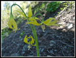
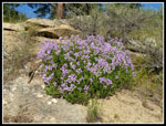
We had a short chat and they headed up Mission Ridge. We soon followed. One more 400' climb to the high point of the day. From the creek up to and all along the ridge there are some huge old Ponderosa Pine trees. The terrain is high grass and big trees. Wildflowers are mixed in. At the top Janet discovered the green tentacle like arms of bitterroot. No flowers in sight yet. The ridge is a long series of short ups and downs. Not a big deal unless you have already hiked more than 11 miles and it is the warmest day of the year so far. We did have some views out to the Stuart Range and what looked like Glacier Peak.
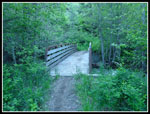
When at long last we finally began to descend the rate was really slow. A mile later I would see that we had lost 100'. At that rate we would be still coming down at midnight. Finally the grade steepened to 10% with a few miles to go. We were both very happy to see the bridge over the creek and the end of the loop. It was just another 5 minutes or so back to the car. There were a few bikers packing up and otherwise the lot was empty. It was 6:30 pm and the end of a long day of hiking.
I'm sure I will be sore for a day or two but it was well worth the effort. We saw very few people and a whole lot of wildflowers. Not as thick as at Ingalls Creek the week before but a really impressive variety of forest and desert flowers in one place. The drive home went fine with no Highway 2 backups in Sultan. With two new knees Janet did great. It might take a while for the memory of the pain to subside but I'm sure I'll return some time in the future.
We met in Monroe at 6:30 am. It was another 106 miles to the trailhead. Traffic was not bad as we crossed Stevens Pass and on to Leavenworth and Cashmere. Per my 100 Hikes In The Alpine Lakes book, go .04 miles from the stop sign in town, turn left on Mission Creek Road, right at the "T" then left immediately after crossing the creek. At the end of pavement we turned left for a few miles to the trailhead. The old road is now part of the creek and the repair has moved it up the hillside a little. Hopefully this time it will not wash away again.
We arrived at the trailhead at 8:45 am and were on the trail at 8:55. This has been a wet and snowy spring and it really shows in the gulch. It is as wet and green as I have ever seen it. Most of my other visits have been in early May but this year I waited a month later for the snow to melt and the creek to subside, at least a little. I really liked hiking clockwise on my earlier loop. Get all the elevation out of the way in the cool morning. This time we went counter clockwise. With a high near 80 degrees we wanted to get in the three fords of Mission Creek before afternoon snow melt caused the creek to rise too much. It is 7 1/2 miles to the last crossing so it does take some time.
Wildflowers began immediately and never let up. Balsamroot, glacier lilies, trillium, and even the elusive Tweedy's lewisia are seen on the loop but we saw many more varieties. I can't recall nor name all the flowers we saw. Here is a short list: penstemon, scarlet gilia, balsamroot, trillium, old man's whiskers, Tweedy's lewisia, glacier lilies, bitterroot, calypso orchids, Indian paintbrush, lupine, wallflower, ballhead waterleaf, phlox, woodland star, mariposa lily, spring beauty, and more. It was a real riot of color. a whole lot more than I was expecting.
Although snow has been gone from the Gulch for some time there were many puddles of water. There must have been a lot of recent rain. It was shorts and short sleeves weather right from the start. We haven't had much of that his year. There were no cars in the lot so we had a head start if motorcycles were coming. These trails are open to motorcycles. I usually see a few and the riders have been extremely courteous on each and every occasion. The Gulch is also popular with mountain bikers. One can continue on the road to the trailhead then ride the trail all the way downhill to the car.
We made good time hiking but with quite a few photo stops. With the length of the hike and the possible dicey creek crossings we chose small light point and shoot cameras instead of heavier and much more expensive DSLRs. On my last visit I was surprised to find several Tweedy's lewisia in bloom above the trail. This time we found more than I remembered. They were mostly a little beyond their peak but still very nice. One big log is down across the trail. With our long legs we were just able to climb across. There were signs of a few motorcycles that have cut way around the tree. Hopefully it can be cut out before the reroute becomes a deep rut.
The first creek crossing was interesting. It was not all that wide and so was fast and deep. We are both 6' 2" or more and the water was above our knees. Janet brought sandals and I crossed in bare feet. With two poles for balance and leverage it was manageable. Now on the left side of the creek we climbed will above the water. The trail went from forest to open rock gardens. The best scarlet gilia was along here. Lots of balsamroot and penstemon too. At about the 5 mile mark we reached the second crossing. It looked like snow melt had raised the water a little since our first crossing. I chose to try crossing a narrow log. The water was so deep here my poles did not reach the creek bottom. I had to just wing it. Not easy but I made it across. Janet though another ford made better sense. She crossed with no problem.
Back on the right side we found more rock gardens. Open slopes with more Tweedy's lewisia and other flowers growing in the rocky hillside. We now had better views across to Mission Ridge and up and down the valley. A few side creeks were easy rock hops. We came to a bigger side creek that required another ford. All these shoes off/shoes on drills took some time. At 7 miles we came to a creek that was just not big enough to be the main channel though at first we thought it might be. We were able to rock hop here. Finally at 7.6 miles was the final crossing. The fact that there were two big side creeks soon before that we had already crossed meant the final creek was not nearly as big as I had feared. It was flowing very fast but not too deep or wide. I managed to jump from a wet rock in the middle and Janet made a final ford.
Now there were no more water crossings but also no more water sources. The final 10 1/2 miles are completely dry. Another benefit of doing the loop clockwise is plenty of water on the way out. The trailhead is at 1750'. The final creek crossing is at 3450'. The high point on Mission Ridge is at about 4850'. After 7 1/2 miles we had a net gain of only 1700'. We now had to gain 1400' more in the next 2 1/2 miles. The trail was built with motorcycles in mind and it switchbacks endlessly. The average grade is a little less than 9%. That is not steep. It was easy walking but took a long distance to gain the elevation. The wildflowers continued unabated. As we rose we had better views across the valley to Tronsen Ridge and Mt. Lillian.
The trail is in good shape until I reached another big tree down across and well beyond the trail. We met the first other people of the day here. Two mountain bikers were heading downhill. We had to work our way around this blow down and another a short way farther. In this normally bone dry area there were actually spots with water running down the trail. At long last we reached the junction with the Mission Ridge Trail. Time for a late lunch break. It was 2:10 at roughly the 10 mile mark. We still had 8 miles to go. The fact this was the first day since last October above the high 60s degrees made it tougher. The nice part was the fact the trail would continuously go from sun to shade. We never overheated too much. A group of 6 motorcyclist came down the Beehive trail. They were the second of three groups we saw all day long.
We had a short chat and they headed up Mission Ridge. We soon followed. One more 400' climb to the high point of the day. From the creek up to and all along the ridge there are some huge old Ponderosa Pine trees. The terrain is high grass and big trees. Wildflowers are mixed in. At the top Janet discovered the green tentacle like arms of bitterroot. No flowers in sight yet. The ridge is a long series of short ups and downs. Not a big deal unless you have already hiked more than 11 miles and it is the warmest day of the year so far. We did have some views out to the Stuart Range and what looked like Glacier Peak.
When at long last we finally began to descend the rate was really slow. A mile later I would see that we had lost 100'. At that rate we would be still coming down at midnight. Finally the grade steepened to 10% with a few miles to go. We were both very happy to see the bridge over the creek and the end of the loop. It was just another 5 minutes or so back to the car. There were a few bikers packing up and otherwise the lot was empty. It was 6:30 pm and the end of a long day of hiking.
I'm sure I will be sore for a day or two but it was well worth the effort. We saw very few people and a whole lot of wildflowers. Not as thick as at Ingalls Creek the week before but a really impressive variety of forest and desert flowers in one place. The drive home went fine with no Highway 2 backups in Sultan. With two new knees Janet did great. It might take a while for the memory of the pain to subside but I'm sure I'll return some time in the future.
Devil's
Mission GPS Map
Janet's photos are here: NWHikers Photos
Click
on thumbnails to get
larger pictures.
Trips - 2011
Home
Janet's photos are here: NWHikers Photos
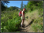 Janet On Trail |
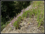 Penstemon |
 Big Tree Down |
 First Tweedy's Lewisia |
 Tweedy's At Peak |
 Calypso Orchids |
 First Creek Crossing |
 Tweedy's Under Log |
 Showy Tweedii |
 Sunny Penstemon |
 Scarlet Gilia |
 Shaky Log Crossing |
 Janet Crossed Here |
 Beautiful Balsamroot |
 Narrow Trail |
 Old Man's Whiskers |
 Creek Far Below |
 Side Creek Crossing |
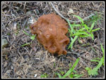 Big Fungus |
 Last Creek Crossing |
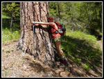 Tree Hugger |
 Across To Tronsen Ridge |
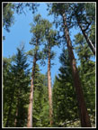 Tall Pines |
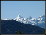 Mt. Stuart |
 The Stuart Range |
 Ridge Top Hiking |
 One Big Balsamroot |
 Four Glacier Lilies |
 Glacier Lilies |
 Spring Beauty |
 Yellow On Black |
 A Brown Ribbon |
 Balsamroot Afire |
 Slabby Ridge |
 Last Tweedy's |
 Bitterroot! |
 Colorful Bitterroot |
 Still More Balsamroot |
 Wallflower |
 Field Of Green |
 Last Penstemon |
 The Bridge At Last |
Trips - 2011
Home