11-06-11
After
a flat and easy 10 miles on the John Wayne Trail the day before, I as
ready for a summit hike. Janet wanted to hike a trail that neither of
us had been on before. Estes Butte it was. Daylight savings time ended
Saturday night so it would be dark by 5:00 pm. With that in mind I set
my alarm for 4:30 am. Groan. I met Janet in Monroe at 6:00 am. The
drive east on Highway 2 was the most uncrowded I an ever recall. Most
of the time there as no car behind or ahead of us. A few weeks back we
hiked up to Carne Basin to see the golden larch trees. Estes Butte is
just down the ridge to the south. In fact, the trail continues over
Estes Butte's lookout site to the real summit then on to Carne Basin.
That's a one way trip I would love to do one day.
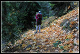
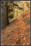
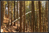
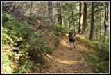
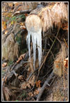
We drove up the Chiwawa River Road once again this time stopping about 3.8 miles after the end of pavement just beyond Rock Creek. All the signs have been removed for winter. There is a signpost for the campground but no sign. One could park along the Chiwawa Road our go into the campground. We went in and found a place to park and the unsigned trail. It was around 8:00 am when we started up the trail. It was cold. Really cold. Must have been in the mid 20s. At least it was sunny and there was no wind. That did not change all day. The route begins on an old road as it parallels Rock Creek. Lots of frozen leaves along here.
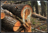
The way begins to gain elevation but remains on the old road for a quick 4/10s of a mile. The road continues on but is blocked by branches and the obvious trail switchbacks up and to the left. My old hiking guides talk about the steep 2 1/2 mile trail to the summit. The most recent trail guide mentions that the route has been rebuilt to be longer and gentler. It now is about 4.35 miles to the top per my GPS. The trailhead is at about 2550' and the lookout site at 5405'. That leaves 2850' of net gain and minimal ups and downs. The route never seems steep as it switchbacks across the face of the butte. Once on the way up and once coming down we noticed cut logs that had ice hanging off them. Strange with no signs of water. The route crosses one small creek near the bottom and no others on the way up.
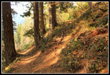
The old trail is met on many occasions. It follows a rib to the left of a watercourse. The new trail reaches it on many right turning switchbacks. My GPS has the new route and Janet's the old making it easy to see where the trails met. Animals have also been busy on the hillside. Many times animal tracks cut right across the trail. Some were as obvious as many old climbers trails. At about 3 1/2 miles the trail reached the rib one more time and it became clear we were now on the old trail. It is much narrower and much steeper. The slope itself moderates here so it is still not all that steep.
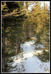
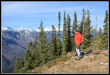
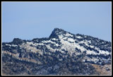
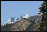
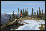
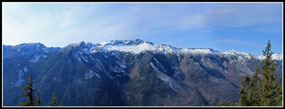
We expected to see snow on the upper mountain but were amazed to see bare dirt even as we neared 5000'. Finally there was some snow the last third of a mile but barely enough to cover the trail. There would be no navigation difficulties this day. As the trail became flat and we approached the lookout elevation I feared that the viewpoint was now filled with trees. The route then popped out of the forest at the old sight. Great views to the west and east with partial views through the trees to the north. It was clear that the real summit was still quite a ways away. The trail dropped down then climbed up a ridge well to the north. It was a great viewpoint to sit down and soak up the sun and the sights.
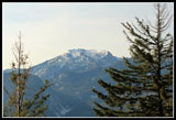
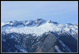
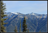
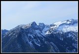
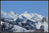
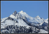
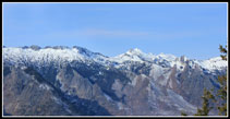
Our moderate pace put us on top at 11:00 am. Looking west we could see crevasses on the glaciers of Clark Mountain. Buck Mountain was partly visible through trees to the northwest. East we saw Garland Peak and Basalt Ridge where I had camped this summer. The Devil's Smokestack was also visible. The ever present Mt. Maude was also in sight directly to the north. This is a great viewpoint. Even better when the peaks have a layer of fresh snow to brighten them. I can't believe it took my almost 30 years to hike up Estes Butte. The trail received maintenance this year as we found several logs freshly sawed out. There are a few new blowdowns but they were easy to step over.
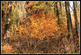
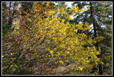
We debated heading on to the real summit but it was 11:40 be then and we had only 5 1/2 hours of daylight left followed by a long drive home. If there was snow on much of the route ahead that would slow us more. We chose to call it good at the lookout site. That still provided about 8.7 miles round trip. The trip down was very easy. The gentle grade was easy on the knees. with no water along the trail there is no need for steps and water bars. It is smooth trail most all the way. It really did not feel like almost 3000' of gain. As I expected we saw exactly zero people all day Added to the zero hikers the day before that meant I hiked 19 miles this weekend without seeing another hiker. Who says the trails are crowded? There was a little fall color along the way and great views from the top. The trail is gentle and smooth. This should be a very popular trail yet I could find only one or two trip reports per year. Go and enjoy it. You will not be disappointed.
Click on thumbnails to get
larger pictures.
Trips - 2011
Home
We drove up the Chiwawa River Road once again this time stopping about 3.8 miles after the end of pavement just beyond Rock Creek. All the signs have been removed for winter. There is a signpost for the campground but no sign. One could park along the Chiwawa Road our go into the campground. We went in and found a place to park and the unsigned trail. It was around 8:00 am when we started up the trail. It was cold. Really cold. Must have been in the mid 20s. At least it was sunny and there was no wind. That did not change all day. The route begins on an old road as it parallels Rock Creek. Lots of frozen leaves along here.
The way begins to gain elevation but remains on the old road for a quick 4/10s of a mile. The road continues on but is blocked by branches and the obvious trail switchbacks up and to the left. My old hiking guides talk about the steep 2 1/2 mile trail to the summit. The most recent trail guide mentions that the route has been rebuilt to be longer and gentler. It now is about 4.35 miles to the top per my GPS. The trailhead is at about 2550' and the lookout site at 5405'. That leaves 2850' of net gain and minimal ups and downs. The route never seems steep as it switchbacks across the face of the butte. Once on the way up and once coming down we noticed cut logs that had ice hanging off them. Strange with no signs of water. The route crosses one small creek near the bottom and no others on the way up.
The old trail is met on many occasions. It follows a rib to the left of a watercourse. The new trail reaches it on many right turning switchbacks. My GPS has the new route and Janet's the old making it easy to see where the trails met. Animals have also been busy on the hillside. Many times animal tracks cut right across the trail. Some were as obvious as many old climbers trails. At about 3 1/2 miles the trail reached the rib one more time and it became clear we were now on the old trail. It is much narrower and much steeper. The slope itself moderates here so it is still not all that steep.
We expected to see snow on the upper mountain but were amazed to see bare dirt even as we neared 5000'. Finally there was some snow the last third of a mile but barely enough to cover the trail. There would be no navigation difficulties this day. As the trail became flat and we approached the lookout elevation I feared that the viewpoint was now filled with trees. The route then popped out of the forest at the old sight. Great views to the west and east with partial views through the trees to the north. It was clear that the real summit was still quite a ways away. The trail dropped down then climbed up a ridge well to the north. It was a great viewpoint to sit down and soak up the sun and the sights.
Our moderate pace put us on top at 11:00 am. Looking west we could see crevasses on the glaciers of Clark Mountain. Buck Mountain was partly visible through trees to the northwest. East we saw Garland Peak and Basalt Ridge where I had camped this summer. The Devil's Smokestack was also visible. The ever present Mt. Maude was also in sight directly to the north. This is a great viewpoint. Even better when the peaks have a layer of fresh snow to brighten them. I can't believe it took my almost 30 years to hike up Estes Butte. The trail received maintenance this year as we found several logs freshly sawed out. There are a few new blowdowns but they were easy to step over.
We debated heading on to the real summit but it was 11:40 be then and we had only 5 1/2 hours of daylight left followed by a long drive home. If there was snow on much of the route ahead that would slow us more. We chose to call it good at the lookout site. That still provided about 8.7 miles round trip. The trip down was very easy. The gentle grade was easy on the knees. with no water along the trail there is no need for steps and water bars. It is smooth trail most all the way. It really did not feel like almost 3000' of gain. As I expected we saw exactly zero people all day Added to the zero hikers the day before that meant I hiked 19 miles this weekend without seeing another hiker. Who says the trails are crowded? There was a little fall color along the way and great views from the top. The trail is gentle and smooth. This should be a very popular trail yet I could find only one or two trip reports per year. Go and enjoy it. You will not be disappointed.
 Leaves On Trail |
 Icicles On Log |
 Orange Leaf Trail |
 Old Trail |
 Silver Arch |
 First View Out |
 Nice Fall Color |
 Snow On Trail |
 Winter Is Here |
 Janet On Summit |
 Basalt Ridge |
 Devil's Smokestack |
 Larch Trees |
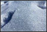 Gleaming Snow Crystals |
 Crevasses |
 Clark Mountain |
 Garland Peak |
 View Northeast |
 Maude & 7 Fingered Jack |
 Lookout Site |
 More Fall Color |
 Hiking Down |
 More Icicles |
 White & Brown |
 Northwest View Panorama |
 Wider Panorama |
Trips - 2011
Home