8-25-12
My
first visit to Foss Lakes was on 8/14/88. A mere 24 years ago. That day
we went as far as Little Heart Lake. Somehow I had never made a return
visit. Friday night I decided it was time. I was out the door just
after 6:00 am. Out Highway 2 then turning right onto the Foss River
Road just a short way after the Ranger Station. The road is in fine
shape. Although it was early Saturday morning there were already a
dozen cars in the lot. It was chilly at 7:55 am when I started out.
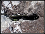
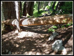
There is one down tree across the trail between Copper and Little Heart
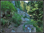
Lakes. That is it. Otherwise there are no problems. The trail is rocky.
Lots of steps. Very little smooth forest walking. With the high
forecast to be about 80 degrees I wanted to get most of the elevation
gain out of the way early. I also wanted time to go farther than Little
Heart Lake.
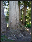
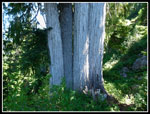
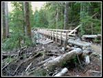
The chill ended quickly. I hiked fast and warmed up fast. My faded memory was of a wide creek crossing on a log. I knew that log had been washed away and others used over the years. What I had missed is that the trail in the first mile has been rerouted to a spot where a high metal I beam bridge has been installed. I noticed another trail reroute near Trout Lake where a big washout scoured the slope. I did not forget the enormous tree after crossing the river. It is right on the trail. Making good time I covered the 1 1/2 miles to Trout Lake in 32 minutes. There were a number of tents at the lake. The trailhead is at about 1600'. Trout Lake is at 2020'. After Trout the trail climbs over 1900' in 2 1/2 miles to Copper Lake. I noted the sign for Malachite Lake just before Copper. The steep trail means big waterfalls as the creek drops fast. Much of it is in forest with some more open slopes higher up.
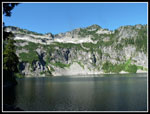
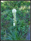
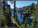
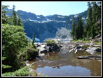
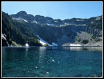
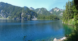
I also vaguely recalled a narrow log crossing the Copper outlet. Now there are a number of big flat rocks placed to allow an easy crossing. It was getting quite warm when I reached Copper. It is a big lake with near vertical walls. The trail is mostly well above the lake. I stopped on the shore near the outlet for a break. A little food and water and some very nice photographs and I was back on my way. Lots of ups and downs along the lake. I met one group camping at the lake. I had not seen many folks so far. Above Copper the trail crosses some small meadows with beargrass still blooming at the end of August.
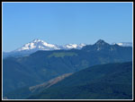
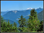
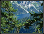
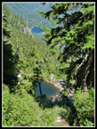
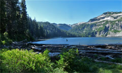
The climb to Little Heart is not far. The lake sits at 4204'. I left the trail and ventured onto the big log jam at the outlet. Since the lake is forested with little accessible shore that is the best place to see down the lake. The morning sun was in my eyes making it tough to get a photo to turn out. The trail from Little Heart to Big Heart Lake was the most interesting of the day. It begins by switchbacking above Little Heart then traversing all around. It is narrow is spots and crosses some steep hillsides. Views appear through the trees to peaks and lakes. I met two groups hiking down. The first spent a week in the valley, camping several nights at Chetwoot Lake where there was still snow. There is none on the trail to Big Heart. I was surprised to find a spot with a clear view of Glacier Peak.
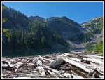
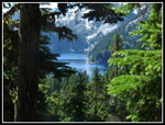
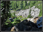
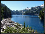
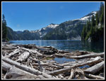
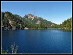
The route climbs to 4900' then begins a descent to Big Heart. I spotted two smaller lakes below and saw Lake Angeline and Big Heart through the trees. I heard lots of pikas while passing through a rocky meadow but did not see any. Easy switchbacks dropped me down to the narrow end of 4545' Big Heart. The trail continues to drop down to the outlet. The lake is very large. There is still some snow on the high ridges above the lake. It was getting very warm by the time I reached the lake. Although I was over seven miles from the trailhead and it was a Saturday morning and two groups had already headed down I saw several groups of campers. This is a popular place and deservedly so. Another big logjam provided a way to get across with dry feet. There was a group at the little bit of shore accessible. Like the other lakes, there is not much flat shoreline.
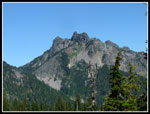
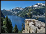
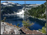
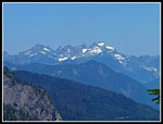
Instead I headed higher as the trail climbed in forest above the lake. I passed a couple at one campsite and continued higher. More views north to Glacier Peak in the distance and Alpine Baldy and Mt. Fernow much closer. At a meadow I followed a short trail to the right that brought me to a campsite. A big rock jutted out over the cliff with great views up and down the lake. It was now noon and time for lunch. This turned out to be an excellent spot to relax and enjoy the views of the peaks and the lake. I would have liked to spend the night. My GPS recorded 7.6 miles to this spot. The trailhead sign stated 7.5 miles to Big Heart Lake. With my early start I still had plenty of time to enjoy the lakes on my way out.
Upon closer inspection I saw that a crack separated the upper part of my lunch rock. I was sitting beyond the crack. The crack went down a long way. Well it survived my weight. Most of the way up was in forest. Now I doubled up on sun screen. Heading back I dropped to the outlet then had to climb back up to the 4900' highpoint. I passed four or five more groups heading in. Most had overnight packs though a few had light day packs. They may have been coming up from campsites at the lower lakes. I passed by Little Heart and continued on to Copper. Just off the trail I found step building logs that provided a good seat. I spent 40 minutes enjoying the lake. At 2:40 pm I headed down. There were now lots of folks in sight. On the trail and down by the lake. On the trip down I met another five or six parties coming up to spend the night.
I crossed the outlet and soon reached the sign for the route to Malachite Lake. The path is short and steep. Probably only a third of a mile up. I already had a 15 mile day but decided to head to Malachite. With 24 years between my first two visits who knows when I'll get back there? The steep rocky climb brought be to the shore of Malachite. There is a grassy spot and it had a tent on it. I spied another tent around to my left. Again the sun was right in my face and photos did not turn out well. Malachite was my fifth lake of the day. I dropped back to the main trail and sped up. No point lingering on the rocky trail back down to Trout Lake. I had a short break at Trout and then headed out the last 1.5 miles.
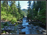
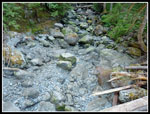
This part went fast. The trail is within earshot of the cascading river much of the way. When I crossed the bridge I realized there was no sound. The river is completely underground at this time. That was a surprise. Farther down it was running once again. I reached the trailhead right at 5:00 pm. That made for a 15.5 mile day in 9 hours with several long stops. It is 3300' from the bottom to the high point with a number of ups and downs. Still, I was surprised when my GPS registered 5200' of gain. This seems too high to me. It was right on at least up to Copper Lake. Still, it was at least close to 5000'.
This turned out to be a very enjoyable day. Five medium to big lakes, few bugs, no snow, not all that many people (few on the way up), and sunshine without debilitating heat. Now I know I need to drag my backpack up and spent at least four days in the West Fork Foss River Valley.
Click on thumbnails to get
larger pictures.
Trips - 2012
Home
The chill ended quickly. I hiked fast and warmed up fast. My faded memory was of a wide creek crossing on a log. I knew that log had been washed away and others used over the years. What I had missed is that the trail in the first mile has been rerouted to a spot where a high metal I beam bridge has been installed. I noticed another trail reroute near Trout Lake where a big washout scoured the slope. I did not forget the enormous tree after crossing the river. It is right on the trail. Making good time I covered the 1 1/2 miles to Trout Lake in 32 minutes. There were a number of tents at the lake. The trailhead is at about 1600'. Trout Lake is at 2020'. After Trout the trail climbs over 1900' in 2 1/2 miles to Copper Lake. I noted the sign for Malachite Lake just before Copper. The steep trail means big waterfalls as the creek drops fast. Much of it is in forest with some more open slopes higher up.
I also vaguely recalled a narrow log crossing the Copper outlet. Now there are a number of big flat rocks placed to allow an easy crossing. It was getting quite warm when I reached Copper. It is a big lake with near vertical walls. The trail is mostly well above the lake. I stopped on the shore near the outlet for a break. A little food and water and some very nice photographs and I was back on my way. Lots of ups and downs along the lake. I met one group camping at the lake. I had not seen many folks so far. Above Copper the trail crosses some small meadows with beargrass still blooming at the end of August.
The climb to Little Heart is not far. The lake sits at 4204'. I left the trail and ventured onto the big log jam at the outlet. Since the lake is forested with little accessible shore that is the best place to see down the lake. The morning sun was in my eyes making it tough to get a photo to turn out. The trail from Little Heart to Big Heart Lake was the most interesting of the day. It begins by switchbacking above Little Heart then traversing all around. It is narrow is spots and crosses some steep hillsides. Views appear through the trees to peaks and lakes. I met two groups hiking down. The first spent a week in the valley, camping several nights at Chetwoot Lake where there was still snow. There is none on the trail to Big Heart. I was surprised to find a spot with a clear view of Glacier Peak.
The route climbs to 4900' then begins a descent to Big Heart. I spotted two smaller lakes below and saw Lake Angeline and Big Heart through the trees. I heard lots of pikas while passing through a rocky meadow but did not see any. Easy switchbacks dropped me down to the narrow end of 4545' Big Heart. The trail continues to drop down to the outlet. The lake is very large. There is still some snow on the high ridges above the lake. It was getting very warm by the time I reached the lake. Although I was over seven miles from the trailhead and it was a Saturday morning and two groups had already headed down I saw several groups of campers. This is a popular place and deservedly so. Another big logjam provided a way to get across with dry feet. There was a group at the little bit of shore accessible. Like the other lakes, there is not much flat shoreline.
Instead I headed higher as the trail climbed in forest above the lake. I passed a couple at one campsite and continued higher. More views north to Glacier Peak in the distance and Alpine Baldy and Mt. Fernow much closer. At a meadow I followed a short trail to the right that brought me to a campsite. A big rock jutted out over the cliff with great views up and down the lake. It was now noon and time for lunch. This turned out to be an excellent spot to relax and enjoy the views of the peaks and the lake. I would have liked to spend the night. My GPS recorded 7.6 miles to this spot. The trailhead sign stated 7.5 miles to Big Heart Lake. With my early start I still had plenty of time to enjoy the lakes on my way out.
Upon closer inspection I saw that a crack separated the upper part of my lunch rock. I was sitting beyond the crack. The crack went down a long way. Well it survived my weight. Most of the way up was in forest. Now I doubled up on sun screen. Heading back I dropped to the outlet then had to climb back up to the 4900' highpoint. I passed four or five more groups heading in. Most had overnight packs though a few had light day packs. They may have been coming up from campsites at the lower lakes. I passed by Little Heart and continued on to Copper. Just off the trail I found step building logs that provided a good seat. I spent 40 minutes enjoying the lake. At 2:40 pm I headed down. There were now lots of folks in sight. On the trail and down by the lake. On the trip down I met another five or six parties coming up to spend the night.
I crossed the outlet and soon reached the sign for the route to Malachite Lake. The path is short and steep. Probably only a third of a mile up. I already had a 15 mile day but decided to head to Malachite. With 24 years between my first two visits who knows when I'll get back there? The steep rocky climb brought be to the shore of Malachite. There is a grassy spot and it had a tent on it. I spied another tent around to my left. Again the sun was right in my face and photos did not turn out well. Malachite was my fifth lake of the day. I dropped back to the main trail and sped up. No point lingering on the rocky trail back down to Trout Lake. I had a short break at Trout and then headed out the last 1.5 miles.
This part went fast. The trail is within earshot of the cascading river much of the way. When I crossed the bridge I realized there was no sound. The river is completely underground at this time. That was a surprise. Farther down it was running once again. I reached the trailhead right at 5:00 pm. That made for a 15.5 mile day in 9 hours with several long stops. It is 3300' from the bottom to the high point with a number of ups and downs. Still, I was surprised when my GPS registered 5200' of gain. This seems too high to me. It was right on at least up to Copper Lake. Still, it was at least close to 5000'.
This turned out to be a very enjoyable day. Five medium to big lakes, few bugs, no snow, not all that many people (few on the way up), and sunshine without debilitating heat. Now I know I need to drag my backpack up and spent at least four days in the West Fork Foss River Valley.
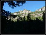 View To Peaks |
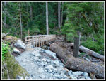 New Bridge |
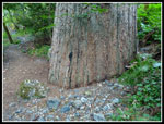 Huge Tree |
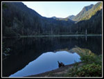 Trout Lake Reflection |
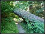 Tree Over Trail |
 Framed Waterfall |
 Complete Waterfall |
 Near Copper Outlet |
 Copper Lake |
 Beargrass |
 Little Heart Lake |
 Malachite Peak? |
 Peaks To The North |
 Glimpse Of Big Heart |
 Meadow & Talus |
 Another Big Tree |
 End Of Big Heart Lake |
 Big Heart Lake |
 Lunch Spot |
 Snow Down To Lake |
 Deep Crack |
 Beckler Peak |
 Big Heart Log Jam |
 Mushroom |
 Lake Angeline |
 Monte Cristo Peaks |
 Narrow Trail |
 Unnamed Lakes |
 Foursome |
 Log Across Trail |
 Relaxing At Copper |
 Copper Outlet Creek |
 Malachite Lake |
 Sparkling Malachite |
 Back To The Bridge |
 River Is Gone |
 Copper Lake Panorama |
 Another Copper Lake Panorama |
Trips - 2012
Home