5-19-12
Another
sunny Saturday and I felt
like heading up for a view hike. I wanted a fairly short drive and
settled on an old favorite, Mt. Baldy. Located on the ridge to the west
of Lake Cle Elum it provides great 360 degree views with no higher
peaks nearby. It is also a very seldom hiked trail especially when
there is still snow. I took the first Easton exit coming from the west.
A left over the freeway, another left, and a right on the Kachess Dam
Road. It immediately turns to dirt. .80 miles to the still officially
unsigned (small yellow paper sign on a tree) right turn then .60 miles
to the trailhead at the end. As expected there were no cars when I
arrived. I was on the go right about 9:00 am.
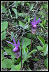
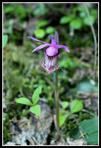
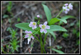
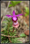
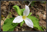
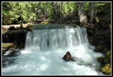
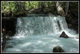
Wildflowers started immediately. Some trillium and calypso orchids. I spent some time photographing the calypsos as I doubted I'd see more. Wrong. This trail is littered with blooming calypso orchids right now. Walking a quarter mile up the trail will let you see a hundred or more. I've never seen so many on one trail before. That slowed me down a number of times. The trail to Baldy is only 8 miles round trip so I had plenty of time to stop for photos. It is one really steep trail, especially the last mile to the top of the ridge. Silver Creek is really roaring right now with spring snow melt. The bridge near the dam/waterfall shakes from the power of the water. It was freezing cold along the creek but warmed up fast as I gained elevation.
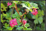
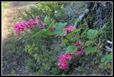
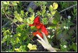
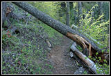
The first few miles have a wide assortment of blooming wildflowers. Not a profusion but pockets of color in spots all along the trail. In addition to all the trillium and calypso orchids I saw vanilla leaf, false Solomons seal, Indian paintbrush, violets, spring beauty, glacier lilies, some chocolate lilies about to open, and more. Much more color than I was expecting. I did not know where the snow would begin so I brought microspikes and and ice axe. The first proved helpful though not absolutely necessary and the latter stayed on my pack. There are two big logs down that you can crawl under and a couple more that you can go around. The trail is in very good shape.
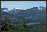
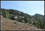
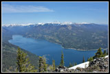
After the very short road section the trail goes up in an old clear cut. Some views out here. More wildflowers too. Back in forest the way switchbacks up to the junction with the Easton Ridge Trail. The junction is on a flat ridge. I went left on the Domerie Divide Trail. The route is flat for a ways. The first small snow patches were in the forest here. I stopped at the lookout spot. Views down to the waterfall on Silver Creek and up to the ridge where the old beacon is. Below is Lake Kachess. Behind it is Amabilis Mountain. I could now see Mt. Rainier. Not a cloud around it. The trail remains flat a short way then begins to climb. I lost the trail at the first bigger snow patch but found it again quickly. After that it was snow free once again.
At the open slope where I had seen many chocolate lilies on an earlier trip I stopped to scan the hillside. The brown lilies are very hard to spot. I'm sure I had walked by them on other visits. I was about to give up when I found one then two and three pods just about to open up. Should be just a day or two. After 3550' of gain on the Old Mt. Si trail just a day and a half earlier my legs really felt the steep section. It used to be a motorcycle trail and in places just goes right up the fall line. "Fall line" is accurate as I have fallen on my rear a few times coming down it with some loose gravel on the steep slope. Without any snow the going was still pretty easy though slow.
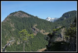
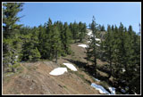
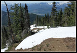
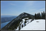
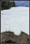
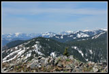
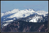
At 4500' a big snow patch covered the trail. Soon after it was buried by up to several feet of snow. The snow was rock hard and I almost stopped to put on the microspikes. Since the ridge top is at 4900' I chose to just keep going. Soon I reached a familiar open spot just a few hundred feet below the ridge. Mt. Baldy was in sight from there. Now in the open the snow was much softer and easier to kick in solid steps. At the ridge top trail junction I would guess there is still 4-6 feet of snow. A left turn goes to Thomas Mountain. I've done that one once on snow and once on dirt trail. Baldy I have done much more often. The ridge to Baldy is one mile with a number of ups and downs. For the most part you can just stay on the ridge top.
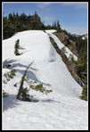
I chose Baldy and immediately dropped down. The snow is well enough consolidated to keep you from post holing much. In some places the wind blown snow makes for 6-10 foot near vertical drops. None proved to be a problem to get up or down. There is one spot where I had to descend on thin icy snow to get around a rocky point. It should be bare in less than a week. I put on microspikes to climb steep hard snow back to the ridge top. On the return it looked like one could scramble right over the rocky point and avoid the ice. That was about it for difficulties. Otherwise, it was just a slog through trees and in the open along the ridge. As I neared the summit of Baldy I stopped to remove my microspikes and heard voices. To my surprise there were two folks and two dogs on top. They came up the other end of the ridge via Domerie Peak.
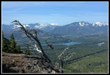
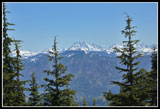
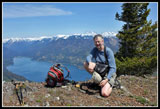
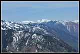
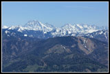
We had a nice chat while I ate lunch. Some clouds were drifting in but it was plenty clear to see from Hinman and Daniel to the north through Mt. Stuart and the Teanaway peaks to Mt. Rainier. Between the bright sun and a cool breeze it was pleasant on top. I arrived at 12:20 and stayed until 1:00 pm. Below the summit I donned microspikes for the whole way back on snow. Not necessary but helpful on the icy spots. One benefit of hiking above a major interstate highway and several small towns is that I had a phone signal for the entire trip. A nice safety feature on a solo snow scramble. The trip back along the ridge was uneventful.
Down below the ridge in forest I left no tracks in the hard snow coming up so I just headed straight down a ways then let my GPS lead me back to the bare trail. I could have hugged the ridge but this was easier as it allowed me to microspike down the harder snow avoiding brush and downed trees. I was soon back on the trail. When I reached the flat ridge and overlook point I was surprised again to find two hikers heading up. Four people is the most I have ever seen on this trail. Still not exactly a crowd. I reached the trailhead at 3:50 to find five other cars. Silver Creek seems to have been more popular this day. The west bound ramp is closed for repaving so I had to go east before I could head west. Traffic was no problem and I was home by 5:30 pm.
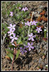
This remains a favorite hike. Good forest wildflowers down low in spring and desert flowers on the ridge after the snow melts. No bitterroot, balsamroot,or scarlet gilia just yet but great flowers in the first few miles. The ridge walk is fun in summer but altogether different on 5 feet of snow. Fun both ways. My GPS logged almost exactly 8 miles round trip with 3800' of gain. I think the elevation is a little high. I'm logging 3600' of gain. Still a great workout with views as well. A great way to spend a sunny day in May.
Click on thumbnails to get
larger pictures.
Trips - 2012
Home
Wildflowers started immediately. Some trillium and calypso orchids. I spent some time photographing the calypsos as I doubted I'd see more. Wrong. This trail is littered with blooming calypso orchids right now. Walking a quarter mile up the trail will let you see a hundred or more. I've never seen so many on one trail before. That slowed me down a number of times. The trail to Baldy is only 8 miles round trip so I had plenty of time to stop for photos. It is one really steep trail, especially the last mile to the top of the ridge. Silver Creek is really roaring right now with spring snow melt. The bridge near the dam/waterfall shakes from the power of the water. It was freezing cold along the creek but warmed up fast as I gained elevation.
The first few miles have a wide assortment of blooming wildflowers. Not a profusion but pockets of color in spots all along the trail. In addition to all the trillium and calypso orchids I saw vanilla leaf, false Solomons seal, Indian paintbrush, violets, spring beauty, glacier lilies, some chocolate lilies about to open, and more. Much more color than I was expecting. I did not know where the snow would begin so I brought microspikes and and ice axe. The first proved helpful though not absolutely necessary and the latter stayed on my pack. There are two big logs down that you can crawl under and a couple more that you can go around. The trail is in very good shape.
After the very short road section the trail goes up in an old clear cut. Some views out here. More wildflowers too. Back in forest the way switchbacks up to the junction with the Easton Ridge Trail. The junction is on a flat ridge. I went left on the Domerie Divide Trail. The route is flat for a ways. The first small snow patches were in the forest here. I stopped at the lookout spot. Views down to the waterfall on Silver Creek and up to the ridge where the old beacon is. Below is Lake Kachess. Behind it is Amabilis Mountain. I could now see Mt. Rainier. Not a cloud around it. The trail remains flat a short way then begins to climb. I lost the trail at the first bigger snow patch but found it again quickly. After that it was snow free once again.
At the open slope where I had seen many chocolate lilies on an earlier trip I stopped to scan the hillside. The brown lilies are very hard to spot. I'm sure I had walked by them on other visits. I was about to give up when I found one then two and three pods just about to open up. Should be just a day or two. After 3550' of gain on the Old Mt. Si trail just a day and a half earlier my legs really felt the steep section. It used to be a motorcycle trail and in places just goes right up the fall line. "Fall line" is accurate as I have fallen on my rear a few times coming down it with some loose gravel on the steep slope. Without any snow the going was still pretty easy though slow.
At 4500' a big snow patch covered the trail. Soon after it was buried by up to several feet of snow. The snow was rock hard and I almost stopped to put on the microspikes. Since the ridge top is at 4900' I chose to just keep going. Soon I reached a familiar open spot just a few hundred feet below the ridge. Mt. Baldy was in sight from there. Now in the open the snow was much softer and easier to kick in solid steps. At the ridge top trail junction I would guess there is still 4-6 feet of snow. A left turn goes to Thomas Mountain. I've done that one once on snow and once on dirt trail. Baldy I have done much more often. The ridge to Baldy is one mile with a number of ups and downs. For the most part you can just stay on the ridge top.
I chose Baldy and immediately dropped down. The snow is well enough consolidated to keep you from post holing much. In some places the wind blown snow makes for 6-10 foot near vertical drops. None proved to be a problem to get up or down. There is one spot where I had to descend on thin icy snow to get around a rocky point. It should be bare in less than a week. I put on microspikes to climb steep hard snow back to the ridge top. On the return it looked like one could scramble right over the rocky point and avoid the ice. That was about it for difficulties. Otherwise, it was just a slog through trees and in the open along the ridge. As I neared the summit of Baldy I stopped to remove my microspikes and heard voices. To my surprise there were two folks and two dogs on top. They came up the other end of the ridge via Domerie Peak.
We had a nice chat while I ate lunch. Some clouds were drifting in but it was plenty clear to see from Hinman and Daniel to the north through Mt. Stuart and the Teanaway peaks to Mt. Rainier. Between the bright sun and a cool breeze it was pleasant on top. I arrived at 12:20 and stayed until 1:00 pm. Below the summit I donned microspikes for the whole way back on snow. Not necessary but helpful on the icy spots. One benefit of hiking above a major interstate highway and several small towns is that I had a phone signal for the entire trip. A nice safety feature on a solo snow scramble. The trip back along the ridge was uneventful.
Down below the ridge in forest I left no tracks in the hard snow coming up so I just headed straight down a ways then let my GPS lead me back to the bare trail. I could have hugged the ridge but this was easier as it allowed me to microspike down the harder snow avoiding brush and downed trees. I was soon back on the trail. When I reached the flat ridge and overlook point I was surprised again to find two hikers heading up. Four people is the most I have ever seen on this trail. Still not exactly a crowd. I reached the trailhead at 3:50 to find five other cars. Silver Creek seems to have been more popular this day. The west bound ramp is closed for repaving so I had to go east before I could head west. Traffic was no problem and I was home by 5:30 pm.
This remains a favorite hike. Good forest wildflowers down low in spring and desert flowers on the ridge after the snow melts. No bitterroot, balsamroot,or scarlet gilia just yet but great flowers in the first few miles. The ridge walk is fun in summer but altogether different on 5 feet of snow. Fun both ways. My GPS logged almost exactly 8 miles round trip with 3800' of gain. I think the elevation is a little high. I'm logging 3600' of gain. Still a great workout with views as well. A great way to spend a sunny day in May.
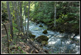 Sliver Creek |
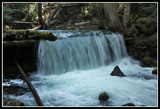 Waterfall |
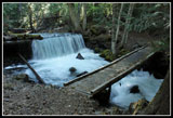 Waterfall & Bridge |
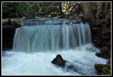 Falls From Bridge |
 Twin Calypso Orchids |
 Lone Calypso Orchid |
 Clolrful Blooms |
 Forest Bloom |
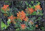 Indian Paintbrush |
 Blooming Shrub |
 Bright Leaves |
 Log Across Trail |
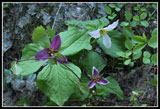 Three Trillium |
 Spring Beauty |
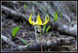 Glacier Lily |
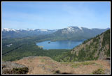 Lake Kachess |
 Rainier & Lake Easton |
 Kachess Ridge |
 Weathered Snag |
 Chocolate Lily |
 A Little Snow On Ridge |
 Baldy In Sight |
 Snowy Ridge Now |
 Mt. Stuart |
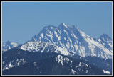 Stuart Close Up |
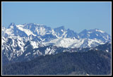 Stuart Range |
 Baldy From Ridge Top |
 Bare Trail! |
 Jim On Baldy Summit |
 Lake Cle Elum Below |
 My Ridge Route |
 Hinman & Daniel |
 The Stuart Range |
 Hawkins Mountain |
 Ridge Walking |
 Phlox |
 Another Calypso Orchid |
 Trillium |
 Falls In Afternon Light |
 Final Falls Photo |
Trips - 2012
Home