7/20-21/13
Kim
wanted to get out of town for
an overnight backpacking trip. We haggled about the destination and
settled on one neither of us had hiked. The trailhead is just three
miles down the road from the very popular North Fork Sauk Trailhead.
Those trails head to White Pass and Pilot Ridge. They are very popular.
The Bald Eagle Trail is probably best known as part of a 24 mile loop
with the Pilot Ridge Trail. We knew that there is little water above
Curry Gap. There is also precious little flat ground. The trail
traverses steep hillsides. That added to the adventure. We were out of
Seattle at 6:45 am and at the end of the North Fork Sauk Road at 9:30
am. The NF Sauk Road is dead center in the middle of the 14 miles of
dirt on the Mountain Loop Highway. We went in via Darrington and out
via Barlow Pass and Granite Falls. The NF Sauk Trailhead had two cars
in the overflow parking area on the main road. It was no surprise when
we arrived to find no cars at our trailhead. By 9:45 am we were on the
trail.
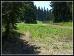
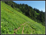
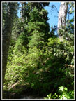
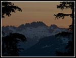
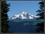
The route begins with a nice hiker and horse bridge over Sloan Creek. The next 2.5 miles are on a long abandoned old logging road. Not the nicest hiking but it leads to much better things. It was fine in the cool morning air. There are several nice waterfalls along the way. At 2.5 miles the route takes a 90 degree left turn and heads up the Bald Eagle Trail. The trailhead is at about 2450'. The road is left at about 3000'. The next 1.5 miles of trail takes you up to Curry Gap at 4000'. Steeper but not much over a 10% grade. We saw columbine right from the start and a number of other wildflowers along the way. Closer to Curry Gap the old clearcut transitions to some impressively big old trees.
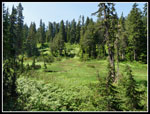
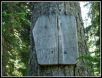
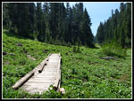
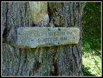
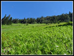
Near the gap the forest gives way to some big meadows. We saw a lot of marsh marigolds last week on the way to Fortune Ponds. There were even more along here. Valerian was also blooming everywhere. Lupine is getting started and I saw one lone Indian paintbrush back on the road section. We were into the meadows before reaching the sign for the Henry Jackson Wilderness. It was much closer to Curry Gap than I had anticipated. The sign is very weather beaten and hard to read. Just after the sign was a campsite with water. Mosquitoes were becoming annoying. Small black flies too though they did not bite. I reached the junction with the Quartz Creek Trail first and waited for Kim. It was getting toasty. Much of the way above would be in forest with plenty of shade.
A report from week before mentioned a campsite at the gap and one where the trail reaches the ridge above. We opted to keep going higher. That trip report also mentioned a snow blocking the trail under Bald Eagle Mountain. Most of the route is below the ridge top and faces south. I expected little if any snow there. Just the section going around Bald Eagle Mountain traverses a north facing slope. How bad the snow crossing was we had no idea. We chose not to bring ice axes. The route climbs at a steady though not overly steep grade above Curry Gap. It is a horse trail. It is also pretty narrow in places. The very steep drop off most all the way would have me too nervous to ride a horse there. There were a number of deep hoof holes right on the edge of the trail in narrow spots.
We found a number of creeks still running. The last one was about 350' below the ridge top. After about 1.5 miles we reached the ridge top. From the map I expected a large flat spot with perhaps a little meadow. No such luck. The ridge top has a campsite in deep dark forest. Bugs and no views with the nearest water 350' below. We headed on. The trail traversed as the ridge began to rise well above us. My GPS track in and out agreed that the map is not correct. The map shows the trail several hundred feet above the real tread in a number of spots. I verified the error on the way out. Now our adventure was picking up steam. There was a little snow near Curry Gap but none at all up above. No more streams. No water. Where to camp?
I had seen one trip report showing a scramble of the peak we were now traversing below. What it called South Bowser Butte connected by a ridge to North Bowser Butte. Bowser Lake was right below. There would likely be some snow on the north side of that ridge and obviously down at Bowser Lake. Since this trip came together the night before, I did not have much info on how to get up there and forgot the brief info in the trip report. Another option would be a camp beyond Bald Eagle Mountain near Long John Mountain. That camp was noted as waterless but it might have snow and it was the only mentioned flat ground as the trail traversed very steep hillsides. We headed on.
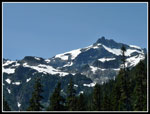
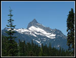
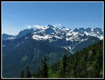
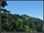
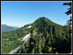
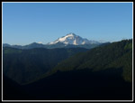
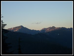
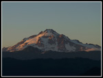
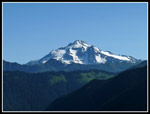
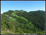
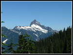
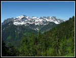
Beyond South Bowser Butte the ridge came back down as the trail met the ridge once again. Along the traverse beneath the butte was forest mixed with some huge meadows. Some flowers out and great views across the Quartz Creek Valley. The Monte Cristo Peaks were right across and that side had a lot of snow and ice. Very picturesque. Back on the ridge the trail drops to a saddle and then heads under Bald Eagle Mountain on the north side. We noticed that the trail was wide enough that a few tents could fit there in a pinch. We were now about 7 miles into our journey. Only a couple more miles to Long John Camp. On we went. Now on the north side our views changed for the better. The south views were excellent but they were even better to the north. Now Glacier Peak was the star with Red and White Passes in front then Pilot Ridge. Indian Head Peak was farther to the right. Black Mountain and the Painted Traverse to the left. Two young hikers had passed by earlier. We now caught up with them. The third member of their party was still behind us. We could now see the nice forested ridge behind us leading up to South Bowser Butte. A big meadowed ridge headed over to the north butte. There was some snow up there. We considered heading back and trying to get up there to camp. Instead we decided to continue ahead.
A few minutes farther along we came to the snow gully. Maybe 60 feet across. Moderately steep with a long slide of several hundred feet down to a boulder field. It would not be pretty if you slipped. The sun was on the snow but the reason it was still there when we had seen no snow anywhere else is the short time each day sun touches it. The snow was hard but kickable. If we braved the crossing we would have to recross it the following morning when it would be much harder. Common sense won out. We chose to retreat. Now we focused on the ridge up to Bowser. The third hiker caught up to the others when we met them again. They were doing the whole 24 mile loop via Pilot Ridge. They too had no ice axes. We described the gully and headed along. The nice forested ridge up to the butte proved to be much different in fact. We hiked up the steep ridge with overnight packs. At one near vertical rock I was able to scramble up and we passed the packs along. I log made it nearly impossible to get up while wearing the pack. Higher up another vertical rock proved to be a deal breaker. Climb around on a very exposed ledge or drop way down on the other side, and climb up a very steep hillside to find??? More rock walls? This was getting way beyond hiking. Down we went. While up on the ridge we did see that the other three hikers were across the snow gully. They did not cross at trail level. Likely they went above where the crossing was shorter.
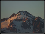
Now that spot in the middle of the trail where it was barely wide enough for tents started looking pretty good. The snow gully ahead would provide water. It was 4:30 pm and we had seen only one group all day. Yep, it was sounding pretty good. So what if my tent was listing 10 degrees to starboard. It fit. We managed to get both tents up and a food line hung. The bugs were annoying but not driving us crazy. We packed up all our cooking gear and headed back to the snow gully. The view north was unobstructed. Glacier Peak right in your face. One of the best backcountry kitchens I have seen. Not only were we camping in the trail we were cooking there too. What a great spot. We cooked up dinner and boiled water to fill our water bottles. The bugs did get bad but I had a jacket and covered myself head to foot. Kim chose bug dope. Both worked well enough. I stayed for sunset on Glacier Peak. My last photo was at 8:45 pm. Kim headed back to escape the bug hordes a little earlier. In our make shift campsite we both slept nearly all night long.
With nearly the whole trip out being downhill we were not in a great hurry in the morning. A long breakfast back at the kitchen and we were backed up and on our way about 10:30 am. From our dinner spot we could see that there was a meadowed saddle in the South Bowser Ridge just below the summit. We wondered if it would be possible to scramble directly up and avoid the rest of the ridge. When we were right under that spot I dropped my pack and headed up. It was much less steep there than any other place along the trail from our campsite. The GPS showed that I was about 350' below that saddle. The map shows the trail about 100' below the saddle. I can verify that is not true. I climbed steep dirt in forest then some berry meadow and into thicker underbrush. About 80' below the saddle it was steeper and entered thick underbrush. Being alone I chose not to go on. I'm pretty sure I could have reached the saddle. That will have to await a future trip. It was much easier than that crazy ridge we tried the day before.
From there it was a pleasant hike down. Great views, some wildflowers, and about as much solitude as one could hope for. We stopped for lunch at a fast flowing stream where we refilled water bottles. We could hear a group with dogs below us on the trail. I saw a dog and Kim saw three people and three dogs. They headed down before us. For the weekend I saw only three other people. Kim saw twice as many as me. Still not many folks. The NF Sauk trailhead was jammed to overflowing and three miles away we see almost nobody. It really is not all that hard to escape crowds while having a great scenic trip. It was much warmer this day than the one before. The last 2.5 miles of the old road was hot and not all that pleasant. I was very pleased to see the trailhead sign.
At the last minute we chose a trail we did not know much about. We realized that water might be a problem. Level ground is a rare commodity up on the ridge. Through it all we had a great time. Fantastic views both days. Huge meadows at Curry Gap and along the high route trail. Some good though not yet astounding wildflowers. Near total solitude. The first time I have ever camped on a trail. Maybe the most scenic on trail kitchen I have used. For the two days I hiked about 15 miles counting two extra trips out to the snow gully/kitchen with about 3500' of gain including two aborted scrambles of South Bowser Butte. It turned out to be an adventure and a great one at that.
Click on thumbnails to get
larger pictures.
Trips - 2013
Home
The route begins with a nice hiker and horse bridge over Sloan Creek. The next 2.5 miles are on a long abandoned old logging road. Not the nicest hiking but it leads to much better things. It was fine in the cool morning air. There are several nice waterfalls along the way. At 2.5 miles the route takes a 90 degree left turn and heads up the Bald Eagle Trail. The trailhead is at about 2450'. The road is left at about 3000'. The next 1.5 miles of trail takes you up to Curry Gap at 4000'. Steeper but not much over a 10% grade. We saw columbine right from the start and a number of other wildflowers along the way. Closer to Curry Gap the old clearcut transitions to some impressively big old trees.
Near the gap the forest gives way to some big meadows. We saw a lot of marsh marigolds last week on the way to Fortune Ponds. There were even more along here. Valerian was also blooming everywhere. Lupine is getting started and I saw one lone Indian paintbrush back on the road section. We were into the meadows before reaching the sign for the Henry Jackson Wilderness. It was much closer to Curry Gap than I had anticipated. The sign is very weather beaten and hard to read. Just after the sign was a campsite with water. Mosquitoes were becoming annoying. Small black flies too though they did not bite. I reached the junction with the Quartz Creek Trail first and waited for Kim. It was getting toasty. Much of the way above would be in forest with plenty of shade.
A report from week before mentioned a campsite at the gap and one where the trail reaches the ridge above. We opted to keep going higher. That trip report also mentioned a snow blocking the trail under Bald Eagle Mountain. Most of the route is below the ridge top and faces south. I expected little if any snow there. Just the section going around Bald Eagle Mountain traverses a north facing slope. How bad the snow crossing was we had no idea. We chose not to bring ice axes. The route climbs at a steady though not overly steep grade above Curry Gap. It is a horse trail. It is also pretty narrow in places. The very steep drop off most all the way would have me too nervous to ride a horse there. There were a number of deep hoof holes right on the edge of the trail in narrow spots.
We found a number of creeks still running. The last one was about 350' below the ridge top. After about 1.5 miles we reached the ridge top. From the map I expected a large flat spot with perhaps a little meadow. No such luck. The ridge top has a campsite in deep dark forest. Bugs and no views with the nearest water 350' below. We headed on. The trail traversed as the ridge began to rise well above us. My GPS track in and out agreed that the map is not correct. The map shows the trail several hundred feet above the real tread in a number of spots. I verified the error on the way out. Now our adventure was picking up steam. There was a little snow near Curry Gap but none at all up above. No more streams. No water. Where to camp?
I had seen one trip report showing a scramble of the peak we were now traversing below. What it called South Bowser Butte connected by a ridge to North Bowser Butte. Bowser Lake was right below. There would likely be some snow on the north side of that ridge and obviously down at Bowser Lake. Since this trip came together the night before, I did not have much info on how to get up there and forgot the brief info in the trip report. Another option would be a camp beyond Bald Eagle Mountain near Long John Mountain. That camp was noted as waterless but it might have snow and it was the only mentioned flat ground as the trail traversed very steep hillsides. We headed on.
Beyond South Bowser Butte the ridge came back down as the trail met the ridge once again. Along the traverse beneath the butte was forest mixed with some huge meadows. Some flowers out and great views across the Quartz Creek Valley. The Monte Cristo Peaks were right across and that side had a lot of snow and ice. Very picturesque. Back on the ridge the trail drops to a saddle and then heads under Bald Eagle Mountain on the north side. We noticed that the trail was wide enough that a few tents could fit there in a pinch. We were now about 7 miles into our journey. Only a couple more miles to Long John Camp. On we went. Now on the north side our views changed for the better. The south views were excellent but they were even better to the north. Now Glacier Peak was the star with Red and White Passes in front then Pilot Ridge. Indian Head Peak was farther to the right. Black Mountain and the Painted Traverse to the left. Two young hikers had passed by earlier. We now caught up with them. The third member of their party was still behind us. We could now see the nice forested ridge behind us leading up to South Bowser Butte. A big meadowed ridge headed over to the north butte. There was some snow up there. We considered heading back and trying to get up there to camp. Instead we decided to continue ahead.
A few minutes farther along we came to the snow gully. Maybe 60 feet across. Moderately steep with a long slide of several hundred feet down to a boulder field. It would not be pretty if you slipped. The sun was on the snow but the reason it was still there when we had seen no snow anywhere else is the short time each day sun touches it. The snow was hard but kickable. If we braved the crossing we would have to recross it the following morning when it would be much harder. Common sense won out. We chose to retreat. Now we focused on the ridge up to Bowser. The third hiker caught up to the others when we met them again. They were doing the whole 24 mile loop via Pilot Ridge. They too had no ice axes. We described the gully and headed along. The nice forested ridge up to the butte proved to be much different in fact. We hiked up the steep ridge with overnight packs. At one near vertical rock I was able to scramble up and we passed the packs along. I log made it nearly impossible to get up while wearing the pack. Higher up another vertical rock proved to be a deal breaker. Climb around on a very exposed ledge or drop way down on the other side, and climb up a very steep hillside to find??? More rock walls? This was getting way beyond hiking. Down we went. While up on the ridge we did see that the other three hikers were across the snow gully. They did not cross at trail level. Likely they went above where the crossing was shorter.
Now that spot in the middle of the trail where it was barely wide enough for tents started looking pretty good. The snow gully ahead would provide water. It was 4:30 pm and we had seen only one group all day. Yep, it was sounding pretty good. So what if my tent was listing 10 degrees to starboard. It fit. We managed to get both tents up and a food line hung. The bugs were annoying but not driving us crazy. We packed up all our cooking gear and headed back to the snow gully. The view north was unobstructed. Glacier Peak right in your face. One of the best backcountry kitchens I have seen. Not only were we camping in the trail we were cooking there too. What a great spot. We cooked up dinner and boiled water to fill our water bottles. The bugs did get bad but I had a jacket and covered myself head to foot. Kim chose bug dope. Both worked well enough. I stayed for sunset on Glacier Peak. My last photo was at 8:45 pm. Kim headed back to escape the bug hordes a little earlier. In our make shift campsite we both slept nearly all night long.
With nearly the whole trip out being downhill we were not in a great hurry in the morning. A long breakfast back at the kitchen and we were backed up and on our way about 10:30 am. From our dinner spot we could see that there was a meadowed saddle in the South Bowser Ridge just below the summit. We wondered if it would be possible to scramble directly up and avoid the rest of the ridge. When we were right under that spot I dropped my pack and headed up. It was much less steep there than any other place along the trail from our campsite. The GPS showed that I was about 350' below that saddle. The map shows the trail about 100' below the saddle. I can verify that is not true. I climbed steep dirt in forest then some berry meadow and into thicker underbrush. About 80' below the saddle it was steeper and entered thick underbrush. Being alone I chose not to go on. I'm pretty sure I could have reached the saddle. That will have to await a future trip. It was much easier than that crazy ridge we tried the day before.
From there it was a pleasant hike down. Great views, some wildflowers, and about as much solitude as one could hope for. We stopped for lunch at a fast flowing stream where we refilled water bottles. We could hear a group with dogs below us on the trail. I saw a dog and Kim saw three people and three dogs. They headed down before us. For the weekend I saw only three other people. Kim saw twice as many as me. Still not many folks. The NF Sauk trailhead was jammed to overflowing and three miles away we see almost nobody. It really is not all that hard to escape crowds while having a great scenic trip. It was much warmer this day than the one before. The last 2.5 miles of the old road was hot and not all that pleasant. I was very pleased to see the trailhead sign.
At the last minute we chose a trail we did not know much about. We realized that water might be a problem. Level ground is a rare commodity up on the ridge. Through it all we had a great time. Fantastic views both days. Huge meadows at Curry Gap and along the high route trail. Some good though not yet astounding wildflowers. Near total solitude. The first time I have ever camped on a trail. Maybe the most scenic on trail kitchen I have used. For the two days I hiked about 15 miles counting two extra trips out to the snow gully/kitchen with about 3500' of gain including two aborted scrambles of South Bowser Butte. It turned out to be an adventure and a great one at that.
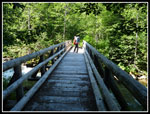 Bridge At Start |
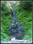 Waterfall |
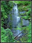 Vertical Waterfall |
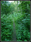 Brushy Road/Trail |
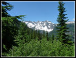 First View Of Peaks |
 Meadows Near Gap |
 Jackson Wilderness |
 Meadow Boardwalk |
 Curry Gap |
 Trails Sign |
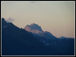
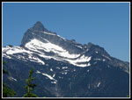
 Kyes Peak |
 Sloan Peak |
 Hillside Meadows |
 Monte Cristo Peaks |
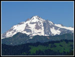 First View - Glacier Peak |
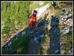
 Scramble Ridge |
 Ridge Scrambling |
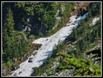 Snow Gully |
 Bald Eagle Mountain |
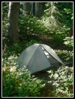 Tent On Trail |
 Kim Is Cooking |
 Distant Glacier Peak |
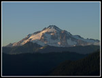 Fading Light On Glacier |
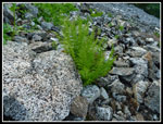 Tough Ferns |
 Indian Head Peak |
 Mt. Saul? |
 Setting Sun |
 Close Up |
 Sunset |
 Morning & Glacier Peak |
 Bowser Buttes |
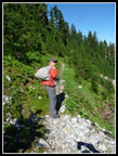 Lightweight Hiker |
 Framed Glacier Peak |
 Sloan Again |
 Monte Cristos Again |
 Meadow Above |
 Sloan Close Up |
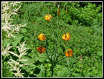 Tiger Lilies |
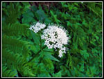 Valerian |
Trips - 2013
Home