7-13-13
Kim
wanted to get out backpacking. I only had one day free for the weekend.
We compromised on a longer day hike. A recent trip report to Fortune
Ponds caught our attention. A trip we had both thought abut for a
decade or more but never done. Fortune Ponds it would be. Gwen signed
on too. We met in Monroe and headed east on Highway 2. Just past
Skykomish we headed up the Beckler River Road. Just after the end of
pavement at about 7 mils we turned right on the Rapid River Road. Some
pot holes but overall the road was in good condition. At 4.4 miles up
that road we came to the 2,000' trailhead and a wide spot large enough
for about four cars. None were present. We were on the trail at just
about 9:00 am.
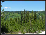
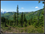
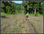
If you want a quick trail to a view or a lake this is not the trail. It is 6.5 miles to the lower pond. Another 1.5 miles up to Pear Lake. Views are minimal before the pond. If you like deep forest, creeks, and few other people this is a great hike. As is often the case, I see few folks on so many of my hikes. The total for this day was two others. Near total solitude. The trail starts in what my old guide book from the early 1970s calls a "late 1960s burn". That was some 45+ years ago. Not big trees but a forest indeed. This day was never hot but the deep forest would keep nearly all the route cooler on a hot day. The grade is mostly gentle as the trail begins with a series of switchbacks. After gaining about 800' in the first mile it settles down to a much easier grade.
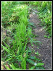
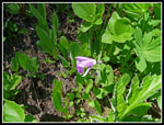
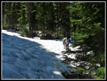
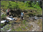
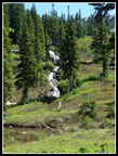
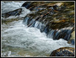
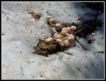
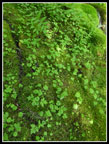
We saw lots of queens cup and bunchberry in bloom. There were a few Indian paintbrush and some lupine that was just short of blooming. After the first mile the burn is left behind. Old growth trees are all around. Some quite large. The forest is dark enough in places that coral root was seen in many places. These plants have no green and do not rely on photosynthesis. The trail turns west and enters the valley of Meadow Creek. At about 2 miles there is a large tree down across the trail. It's a tight fit to go beneath. Going over is even harder. The hillside is too steep and the tree to long to go around it. The next mile of trail is at a very gentle grade. We crossed some short snow patches before reaching the crossing of Meadow Creek at about 3.25 miles.
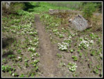
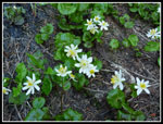
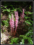
The rocks were barely above the water and looked very slick. I took off my boots and waded across. Cold water but not frigid. The trail was under snow in a number of spots but not hard to follow. Shortly we left most of the snow behind. The creek near Fortune Pass is a wide grassy bog/meadow. The trail stays slightly above the muck. There was water running down the trail in spots but it was not deep or muddy. We had seen some marsh marigolds after nearing the creek crossing. Now it was just plain ridiculous. Thousands of them in bloom. As many as I have every seen in one place. Throw in some shooting stars to add to the color. They are right at their peak now.
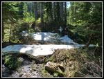
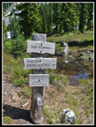
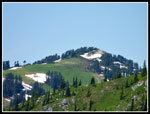
Crossing back to the other side of the creek was now much easier. Just a couple rocks to hop. The trail now begins the climb to the ponds. Gwen noticed the sign nearly hidden on a big tree off to the side of the trail. It once read "Fortune Pass Elevation 4000 Ft". It is bent to a 45 degree angle by the growing tree and now reads "Fort Ass Elev 0 Ft". A little humor courtesy of Mother Nature. It is 2.5 more miles with 700' of gain to reach the lower Fortune Pond. As with the rest of the trail it climbs at a fairly easy grade with a few switchbacks. At one point the trail continues ahead but a more obvious switchback is the real trail. Not sure where the spur heads.We rounded the ridge Fortune Mountain well above us and headed east towards the Cascade Crest. As we neared the pond the north facing slope began to be snow covered. The snow is still a few feet deep in spots. There is bare trail between the patches and we had no trouble picking up the route after each crossing.
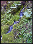
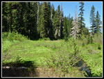
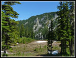
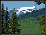
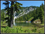
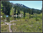
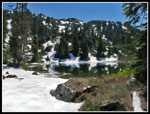
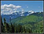
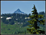
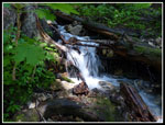
The trail finally left forest for more open terrain. Green meadowed ridges were in sight to the north. At one point we saw West Cady Ridge through the trees. In the open it was blocked by a nearer ridge. Lots of water from snow melt along here. Waterproof boots were helpful. At long last we could see the lower Fortune Pond ahead and below us. A big waterfall flows between the upper and lower pond. We could now see Kyes Peak to the northwest. Still lots of snow on it's south side. It did not take long to drop to the pond. The old Crest Trail went right by. There is now a sign for "abandoned trail". We could see the trail climbing the green slopes of the nearby ridge. That would be a fun piece of history to hike one day.
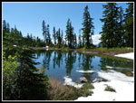
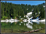
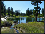
Time to finish lunch and take a break. The pond is ringed by meadows and some trees. A very sub alpine feel. There were flies and skeeters though they were not very bothersome. Within a few days I expect they will be. Not a cloud in the sky but only mid 60s temperatures were exactly what I like. The sunshine made it feel much warmer. After a while we decided to go look for the upper pond. It is located about 200' directly above the lower. We gained half that elevation on the trail then when it went left we went right and uphill. Steep heather led to the upper pond. While the lower tarn had some snow on the far north side. The upper pond had much more. Part of the shore was still snow covered. From near the outlet we could see West Cady Ridge, Benchmark Mountain, Kyes, the Monte Cristo Peaks and Sloan Peak. We went around to the far shore. It was well worth the effort to make the visit.
By the time we dropped back to the lower pond and did some more lounging it was 3:00 pm. Time to head back. I will be back with a tent in the near future. With this as a base one could explore the old Crest Trail. Head up and over to Peak Lake and the current PCT. Scramble up Fortune Mountain. Even pick a few berries in the fall. The trip down was nearly all downhill. Just a few spots of climbing. After crossing the upper snow patches we met the two guys heading in to camp. Lucky them. We were back at the car at about 7:15 pm.
It's hard to believe it took me 31 years to hike this trail. Not that far from Seattle, lots of mileage, and a pretty nice payoff at the end. Well worth the wait. Next time I'll plan to spend a few days up there.
Click on thumbnails to get
larger pictures.
Trips - 2013
Home
If you want a quick trail to a view or a lake this is not the trail. It is 6.5 miles to the lower pond. Another 1.5 miles up to Pear Lake. Views are minimal before the pond. If you like deep forest, creeks, and few other people this is a great hike. As is often the case, I see few folks on so many of my hikes. The total for this day was two others. Near total solitude. The trail starts in what my old guide book from the early 1970s calls a "late 1960s burn". That was some 45+ years ago. Not big trees but a forest indeed. This day was never hot but the deep forest would keep nearly all the route cooler on a hot day. The grade is mostly gentle as the trail begins with a series of switchbacks. After gaining about 800' in the first mile it settles down to a much easier grade.
We saw lots of queens cup and bunchberry in bloom. There were a few Indian paintbrush and some lupine that was just short of blooming. After the first mile the burn is left behind. Old growth trees are all around. Some quite large. The forest is dark enough in places that coral root was seen in many places. These plants have no green and do not rely on photosynthesis. The trail turns west and enters the valley of Meadow Creek. At about 2 miles there is a large tree down across the trail. It's a tight fit to go beneath. Going over is even harder. The hillside is too steep and the tree to long to go around it. The next mile of trail is at a very gentle grade. We crossed some short snow patches before reaching the crossing of Meadow Creek at about 3.25 miles.
The rocks were barely above the water and looked very slick. I took off my boots and waded across. Cold water but not frigid. The trail was under snow in a number of spots but not hard to follow. Shortly we left most of the snow behind. The creek near Fortune Pass is a wide grassy bog/meadow. The trail stays slightly above the muck. There was water running down the trail in spots but it was not deep or muddy. We had seen some marsh marigolds after nearing the creek crossing. Now it was just plain ridiculous. Thousands of them in bloom. As many as I have every seen in one place. Throw in some shooting stars to add to the color. They are right at their peak now.
Crossing back to the other side of the creek was now much easier. Just a couple rocks to hop. The trail now begins the climb to the ponds. Gwen noticed the sign nearly hidden on a big tree off to the side of the trail. It once read "Fortune Pass Elevation 4000 Ft". It is bent to a 45 degree angle by the growing tree and now reads "Fort Ass Elev 0 Ft". A little humor courtesy of Mother Nature. It is 2.5 more miles with 700' of gain to reach the lower Fortune Pond. As with the rest of the trail it climbs at a fairly easy grade with a few switchbacks. At one point the trail continues ahead but a more obvious switchback is the real trail. Not sure where the spur heads.We rounded the ridge Fortune Mountain well above us and headed east towards the Cascade Crest. As we neared the pond the north facing slope began to be snow covered. The snow is still a few feet deep in spots. There is bare trail between the patches and we had no trouble picking up the route after each crossing.
The trail finally left forest for more open terrain. Green meadowed ridges were in sight to the north. At one point we saw West Cady Ridge through the trees. In the open it was blocked by a nearer ridge. Lots of water from snow melt along here. Waterproof boots were helpful. At long last we could see the lower Fortune Pond ahead and below us. A big waterfall flows between the upper and lower pond. We could now see Kyes Peak to the northwest. Still lots of snow on it's south side. It did not take long to drop to the pond. The old Crest Trail went right by. There is now a sign for "abandoned trail". We could see the trail climbing the green slopes of the nearby ridge. That would be a fun piece of history to hike one day.
Time to finish lunch and take a break. The pond is ringed by meadows and some trees. A very sub alpine feel. There were flies and skeeters though they were not very bothersome. Within a few days I expect they will be. Not a cloud in the sky but only mid 60s temperatures were exactly what I like. The sunshine made it feel much warmer. After a while we decided to go look for the upper pond. It is located about 200' directly above the lower. We gained half that elevation on the trail then when it went left we went right and uphill. Steep heather led to the upper pond. While the lower tarn had some snow on the far north side. The upper pond had much more. Part of the shore was still snow covered. From near the outlet we could see West Cady Ridge, Benchmark Mountain, Kyes, the Monte Cristo Peaks and Sloan Peak. We went around to the far shore. It was well worth the effort to make the visit.
By the time we dropped back to the lower pond and did some more lounging it was 3:00 pm. Time to head back. I will be back with a tent in the near future. With this as a base one could explore the old Crest Trail. Head up and over to Peak Lake and the current PCT. Scramble up Fortune Mountain. Even pick a few berries in the fall. The trip down was nearly all downhill. Just a few spots of climbing. After crossing the upper snow patches we met the two guys heading in to camp. Lucky them. We were back at the car at about 7:15 pm.
It's hard to believe it took me 31 years to hike this trail. Not that far from Seattle, lots of mileage, and a pretty nice payoff at the end. Well worth the wait. Next time I'll plan to spend a few days up there.
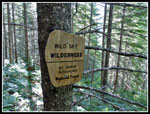 Wild Sky |
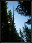 Silver Spire |
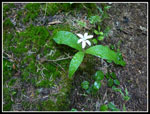 Queens Cup |
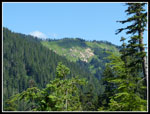 First Views |
 Ferns |
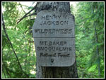 Jackson Wilderness |
 Cascades |
 First Snow Patches |
 Marsh Marigolds |
 Shooting Star |
 Meadows |
 Fort Ass |
 Bigger Snow Patches |
 High Meadows |
 Pond In Sight |
 Creek Crossing |
 Kyes Peak |
 Lower Fortune Pond |
 Junction |
 Fortune Mountain |
 Snowy Upper Pond |
 Reflection |
 Upper Pond |
 Snowy Peaks |
 West Cady Ridge |
 Sloan Peak |
 Benchmark Mountain |
 Lower Pond Again |
 Waterfall |
 Heading Back |
 Small Creek |
 More Marsh Marigolds |
 Meadow Creek |
 Shrooms & Snow |
 Coral Root |
 Shades Of Green |
Trips - 2013
Home