2-10-13
I
had been meaning to hike the road
to trail conversion Granite Creek Trail since I heard that it had been
finished. Photos showed that the wide old road was now a narrow trail.
I knew that all the culverts were gone and that the bridge over Granite
Creek was replaced by a log high over the water. A possibly icy log. I
packed snowshoes and headed for the Middle Fork of the Snoqualmie. The
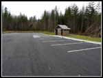
gate just beyond the Mailbox Peak trailhead was gone. In it's place is
a larger parking area. maybe enough for five or six cars vs. the two or
three before. The trail snakes between several logs and heads up the
old road bed. There was one car at the trailhead and two hikers just
ahead of me as I started out at
8:30 am. There was fog all over the Seattle area that faded to largely
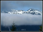
blue sky in North Bend. Up the Middle Fork it was partly blue and
mostly cloudy.
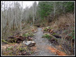
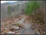
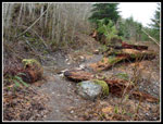
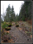
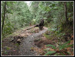
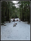
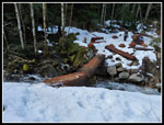
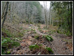
The first thing I noticed about the new trail is that it meanders from one side of the old road bed to the other. At first there are no straight parts. Some meandering is good. This seems like overkill to me. The many creek crossings are easy to cross. Most have several flat rocks to ease the crossings. This new trail will have fans and those who hate the job. There are a few things I do not like but all in all I call it a success. In a few years this trail will not look at all like a road. One other thing I did not notice on the way in but did on the way out. There are many short ups and downs. The old road was smooth but the new trail is constantly making short two or three foot ups and downs. A few are for stream crossings or water drainage. Most are just the way the trail was purposely built. Usually the way downhill is all downhill. On this trail you make very small climbs all the way down. Finally, there are a number of small fir trees that were planted right on the edge of the trail, often in the middle of the old road. As these trees grow they will place branches right in the trail. Why not put the trees several feet off the trail? A dozen or more of these trees are also now leaning at a 30 - 40 degree angle across the trail. Almost none are growing straight up or leaning away from the trail.
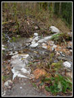
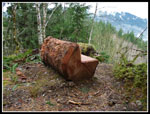
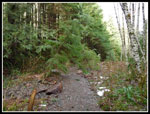
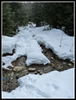
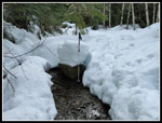
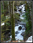
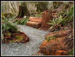
Having dwelt on what I did not like, I'll add the positive points. It looks like a trail not a road. Some of the tread is rocky but there is dirt most of the way. Steps and man made features are minimal. I like the series of wooden benches along the trail, starting right at the trailhead. Instead of bridges the small creeks have strategically placed rocks. Easy to cross but not overbuilt. Speaking of side creeks, there are dozens of them. With all the culverts under the old road I hardly thought of creeks. Now you get to drop down and cross them all. As mentioned the large flat rocks in the creeks should make crossing easy even at high water.
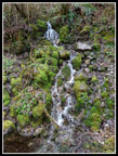
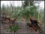
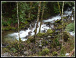
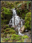
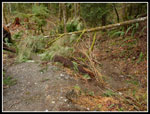
A few minutes up the trail I passed the two hikers and their dogs. At that point there is a log down across the new trail. A trail has been beaten in to avoid it. I hope It is cut out before the bypass becomes the trail. I reached the first of two sets of switchbacks on the day in good time. A fast pace but with numerous quick photo stops. It will be interesting to compare these photos of the new trail to what it looks like in five to ten years. There is a nice mall waterfall after the switchback. As the route switches back to the left it really looks different. Much more like a trail than a road. As the route cut under the steep ridge of Mailbox Peak I looked for the shortcut trail coming up from near the Middle Fork bridge. I used to know what the junction looked like but not any more. I completely missed it. I did better on the way out.
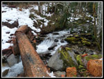
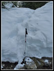
A very short side trail goes to a viewpoint of the falls along Granite Creek. A little snow started here. A few minutes later I reached the old concrete bridge site. It certainly is different now. The creek crossing lot was a little wider than it appeared in the photos I had seen. I would be very nervous crossing if it was icy. It appeared to be mostly dry. There are several benches set here for those resting or just admiring the rushing creek. I stopped in the middle of the log to get a shot of the creek. Staring up I was overconfident and nearly lost my balance on a slick spot. It is fine to cross but be careful.
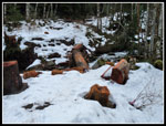
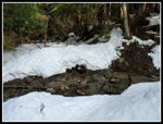
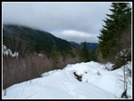
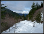
After the bridge I was mostly out of forest and snow quickly covered the road/trail. I did not see anymore dirt so I can't say much about the trail conversion beyond here. There were many footprints then left a packed and slick track to follow. Poles were very helpful. I did not put on microspikes as there are many small creeks to cross up to the Granite Lakes spur. I did not want to bang them on the rocks in the creeks. As the snow became one then two feet deep I did not have any post holing problems. The creek crossings were still pretty easy.
Higher up I met the owner of the first car in the lot. He had reached his turn around time and was coming down. A quick "hi" turned into a ten minute discussion. He was not happy with the make over. Too much weaving and extra ups and downs. More negative than my impressions. It was interesting to compare our feelings about the road conversion. I made it to just past the second set of switchbacks when I stopped to put on snowshoes. The snow was mostly firm but i was beginning to post hole. As I finished putting them on I heard the first two hikers and saw one dog. I took off and never did see them again.
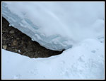
The snow depth really increased as the trail climbed. Now the creek crossings became more difficult. Dropping three of four feet and climbing up the soft snow on the other side. As they reached five to six feet deep it was much harder. I crossed a few on snow bridges that seemed strong enough. Very near the junction with the lakes I reached a creek crossing that I chose not to try. It was now about seven feet deep with soft vertical snow on both sides. My buried my pole in soft snow more than a foot from the edge. The part that had a snow bridge engendered no confidence. Being along I was not at all sure I would be able to crawl back out of the pit. Time to turn around.
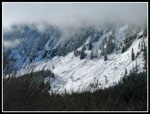
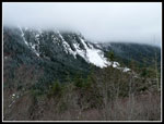
The sun had come out. I could not see the top of Mailbox or Dirty Harry's Peak but I could see peaks between Green and South Bessemer on the far ridge. It was only 11:15, just a mile from the lakes, and it was time for lunch then the descent. As usually happens my snowshoes stayed on well beyond where they went on. A little banging on rocks in the creeks but good flotation and traction where it was icy. I passed one solo hiker coming up. Back at the crossing of Granite Creek I took off my snowshoes. There were two hikers on a bench. The rest of the way down was much quicker. I looked for the shortcut trail junction and first spotted a hiker down below the trail. Yes, he was on the shortcut. The turn off is a "Y" when heading down. It is not very obvious. Almost impossible to see when heading up. I saw a few more hikers who were coming up.
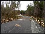
I reached the bottom at 1:35 pm. It only took about two hours to come down. I drove the short distance to the Mailbox parking. I hiked the new paved road up to the new Mailbox parking lot. It seems in the few years since I last hiked Mailbox the start of the trail has been moved. It looks like the paved road is the new start. I followed the gravel road higher to the board marking the old Mailbox trail. With any luck the new Mailbox Peak trail will be finished this year.
This was a fun day. I checked my log and my first hike to Granite Lakes was in 1990. A lot has changed over 23 years. Active logging has given way to a trail in place of the road. I'll be back after the snow melts to check out the rest of the new trail. With my detour up the start of the Mailbox trail I finished with about 10 miles and 2600' of gain. I'll use a GPS next time and see how much distance and elevation gain is added with all the weaving and ups and downs built into the new trail.
Click on thumbnails to get
larger pictures.
Trips - 2013
Home
The first thing I noticed about the new trail is that it meanders from one side of the old road bed to the other. At first there are no straight parts. Some meandering is good. This seems like overkill to me. The many creek crossings are easy to cross. Most have several flat rocks to ease the crossings. This new trail will have fans and those who hate the job. There are a few things I do not like but all in all I call it a success. In a few years this trail will not look at all like a road. One other thing I did not notice on the way in but did on the way out. There are many short ups and downs. The old road was smooth but the new trail is constantly making short two or three foot ups and downs. A few are for stream crossings or water drainage. Most are just the way the trail was purposely built. Usually the way downhill is all downhill. On this trail you make very small climbs all the way down. Finally, there are a number of small fir trees that were planted right on the edge of the trail, often in the middle of the old road. As these trees grow they will place branches right in the trail. Why not put the trees several feet off the trail? A dozen or more of these trees are also now leaning at a 30 - 40 degree angle across the trail. Almost none are growing straight up or leaning away from the trail.
Having dwelt on what I did not like, I'll add the positive points. It looks like a trail not a road. Some of the tread is rocky but there is dirt most of the way. Steps and man made features are minimal. I like the series of wooden benches along the trail, starting right at the trailhead. Instead of bridges the small creeks have strategically placed rocks. Easy to cross but not overbuilt. Speaking of side creeks, there are dozens of them. With all the culverts under the old road I hardly thought of creeks. Now you get to drop down and cross them all. As mentioned the large flat rocks in the creeks should make crossing easy even at high water.
A few minutes up the trail I passed the two hikers and their dogs. At that point there is a log down across the new trail. A trail has been beaten in to avoid it. I hope It is cut out before the bypass becomes the trail. I reached the first of two sets of switchbacks on the day in good time. A fast pace but with numerous quick photo stops. It will be interesting to compare these photos of the new trail to what it looks like in five to ten years. There is a nice mall waterfall after the switchback. As the route switches back to the left it really looks different. Much more like a trail than a road. As the route cut under the steep ridge of Mailbox Peak I looked for the shortcut trail coming up from near the Middle Fork bridge. I used to know what the junction looked like but not any more. I completely missed it. I did better on the way out.
A very short side trail goes to a viewpoint of the falls along Granite Creek. A little snow started here. A few minutes later I reached the old concrete bridge site. It certainly is different now. The creek crossing lot was a little wider than it appeared in the photos I had seen. I would be very nervous crossing if it was icy. It appeared to be mostly dry. There are several benches set here for those resting or just admiring the rushing creek. I stopped in the middle of the log to get a shot of the creek. Staring up I was overconfident and nearly lost my balance on a slick spot. It is fine to cross but be careful.
After the bridge I was mostly out of forest and snow quickly covered the road/trail. I did not see anymore dirt so I can't say much about the trail conversion beyond here. There were many footprints then left a packed and slick track to follow. Poles were very helpful. I did not put on microspikes as there are many small creeks to cross up to the Granite Lakes spur. I did not want to bang them on the rocks in the creeks. As the snow became one then two feet deep I did not have any post holing problems. The creek crossings were still pretty easy.
Higher up I met the owner of the first car in the lot. He had reached his turn around time and was coming down. A quick "hi" turned into a ten minute discussion. He was not happy with the make over. Too much weaving and extra ups and downs. More negative than my impressions. It was interesting to compare our feelings about the road conversion. I made it to just past the second set of switchbacks when I stopped to put on snowshoes. The snow was mostly firm but i was beginning to post hole. As I finished putting them on I heard the first two hikers and saw one dog. I took off and never did see them again.
The snow depth really increased as the trail climbed. Now the creek crossings became more difficult. Dropping three of four feet and climbing up the soft snow on the other side. As they reached five to six feet deep it was much harder. I crossed a few on snow bridges that seemed strong enough. Very near the junction with the lakes I reached a creek crossing that I chose not to try. It was now about seven feet deep with soft vertical snow on both sides. My buried my pole in soft snow more than a foot from the edge. The part that had a snow bridge engendered no confidence. Being along I was not at all sure I would be able to crawl back out of the pit. Time to turn around.
The sun had come out. I could not see the top of Mailbox or Dirty Harry's Peak but I could see peaks between Green and South Bessemer on the far ridge. It was only 11:15, just a mile from the lakes, and it was time for lunch then the descent. As usually happens my snowshoes stayed on well beyond where they went on. A little banging on rocks in the creeks but good flotation and traction where it was icy. I passed one solo hiker coming up. Back at the crossing of Granite Creek I took off my snowshoes. There were two hikers on a bench. The rest of the way down was much quicker. I looked for the shortcut trail junction and first spotted a hiker down below the trail. Yes, he was on the shortcut. The turn off is a "Y" when heading down. It is not very obvious. Almost impossible to see when heading up. I saw a few more hikers who were coming up.
I reached the bottom at 1:35 pm. It only took about two hours to come down. I drove the short distance to the Mailbox parking. I hiked the new paved road up to the new Mailbox parking lot. It seems in the few years since I last hiked Mailbox the start of the trail has been moved. It looks like the paved road is the new start. I followed the gravel road higher to the board marking the old Mailbox trail. With any luck the new Mailbox Peak trail will be finished this year.
This was a fun day. I checked my log and my first hike to Granite Lakes was in 1990. A lot has changed over 23 years. Active logging has given way to a trail in place of the road. I'll be back after the snow melts to check out the rest of the new trail. With my detour up the start of the Mailbox trail I finished with about 10 miles and 2600' of gain. I'll use a GPS next time and see how much distance and elevation gain is added with all the weaving and ups and downs built into the new trail.
 Start Of Trail |
 Rock Steps At Crossing |
 Meandering Trail |
 Logs & Rocks |
 Waterfall |
 Leaning Tree |
 Crossing Meadow |
 Log Bench |
 Placed Log |
 Two Leaners |
 Granite Creek |
 Granite Creek Crossing |
 Log Bridge |
 Thin Snow Cover |
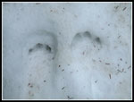 Paw Prints |
 Creek Crossing |
 Deeper Snow |
 Still An Easy Crossing |
 View Towards Lakes |
 Low Clouds |
 Mailbox In Clouds |
 Seven Feet Deep |
 Deep Crossing |
 Peaks In View |
 Peaks Over Clouds |
 Back To Log Bridge |
 Roaring Creek |
 Planted Ferns |
 Waterfall Close Up |
 Tree Across Trail |
 Bench At Start |
 Road To Mailbox Lot |
 New Mailbox Lot |
Trips - 2013
Home