6-15-13
Earlier
this year I explored the new Pratt River Connector trail. I followed it
up onto the old railroad grade and another mile along it. Years ago I
poked around for the other end of this long abandoned trail at the
upper end located at Pratt Lake. With a beautiful sunny day on tap I
headed out for a day of returning to often visited lakes and some
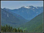
exploring as well. I headed up I-90 to the Pratt Lake/Granite Mountain
trailhead. The main lot was mostly full at 8:35 am. It was already warm
enough for short sleeves. Reports from the previous weekend showed snow
around Olallie Lake and snow on the trail just above the Pratt -
Talapus/Olallie Lakes junction. I was prepared for some moderately deep
snow on the north side of the ridge dropping to Pratt Lake.
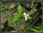
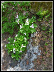
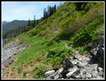
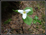
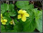
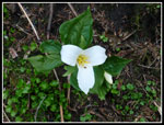
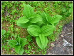
A moderate display of flowers greeted me along the Pratt Lake trail. Vanilla Leaf, plus some trillium, and yellow violets. I did find a blooming wild ginger on the way back. The creeks were no trouble to cross with dry feet in the morning and also in the afternoon. There is not much snow left to melt on the south side of Granite Mountain. I met a few groups coming out and one faster duo with light packs and tennis shoes They did just fine on the snow above.
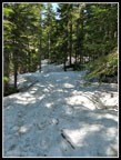
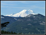
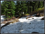
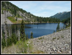
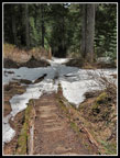
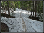
The trail was snow free to the Talapus/Olallie junction. Just a few minutes farther along snow covered the trail. It was well compacted and only a foot or so deep. After a few tenths of a mile I was surprised as the trail reverted to dirt. Only in the last few tenths before the Olallie inlet creek crossing did snow reappear. It was several feet deep near the crossing but the crossing itself is snow free. More snow on the other side as the trail is in the open. When it shortly goes back into forest the snow disappeared It was bare all the way to the Pratt Lake junction and beyond. At the Olallie Lake/Mt. Rainier viewpoint I could see snow all around the lake. Mt. Rainier was cloud free. I still expected snow on the north side of the ridge. I was wrong.
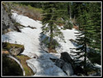
The junction was snow free. I started down a bare trail on the north side. No snow at 4200' on a shaded north slope in mid June? Much less snow that the past few years. There were a few small snow patches in the forest. Very few. I brought gaiters and never bothered to put them on. Down lower the trail leaves forest. There were some sizable snow patches there. The danger was not sliding or losing the route. It was just post holing over talus fields. After a longer snow section it was bare dirt and rock once again. The night before I checked the map on my GPS. It included the Pratt Valley trail and to my surprise it had a dashed line for the old Pratt Lake trail down from the ridge. I hiked that many times before th longer route was opened. The top was not obvious even with the map and GPS. The bottom junction I knew well. Perhaps I could return on a shorter route without any snow?
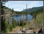
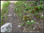
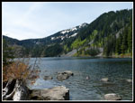
When the trail grade flattened snow patches returned. None very deep. They will be gone in a week or two. There were plenty of tracks in the snow. Lots of folks have been down to the lakes already this year. After what seemed like a long time the trail finally reached Pratt Lake. No snow was seen from this point on. The trail is in fine shape. One downed log before the lake. That was it for the whole day except for a big log across the trail near Lower Tuscohatchie Lake. That one has been there for a decade. The trail along the lake is plastered with trillium and yellow violets. They line the trail all the way along the lake. One of the best displays of those two I have seen. I stopped to talk with one returning hiker at Pratt who had easily found the start of the Pratt Valley trail. That was a good sign.
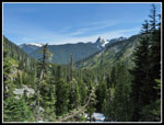
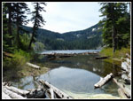
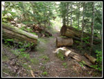
At the end of the lake I dropped down to the outlet. There were two groups at the lake already. I knew the trail was on the other side of the outlet creek. The creek is very wide at the end of the lake. One log jam required a big jump to get from log to log in the middle. I went farther down to another log jam. This one worked. On the other side I found a wall of slide alder. Many cuts and a quantity of blood later I fought my way through. I headed downstream and shortly found the trail. A sign announces "PRATT LK. TR. NO. 1007 - M. FK. SNOQUALMIE R. 10 - TR. NOT MAINTAINED". In fact, at least the start of the trail is in fine shape. I followed it for .50 miles finding many very old cuts of logs. I have now done all of the 20+ miles of the trail from I-90 to the Middle Fork Snoqualmie River trailhead except for about 7.5 miles in the middle. I will have to rectify that soon.
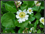
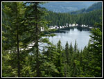
I followed the trail back up to the outlet creek and found that large flat rocks spanned the creek here. I easily crossed with no more blood shed. The trail continued on the other side right back to the main trail. It was still only 12:30 pm so I turned left and continued on towards Lower Tuscohatchie Lake. Lots more trillium and violets along here. Add in a huge number of marsh marigolds in bloom and a few glacier lilies. In short order I arrived at Lower Tuscohatchie Lake. I was the only person at the lake outlet. I crossed the bridge to the site of the old shelter. At the next outlet creek crossing I climbed up onto a big rock on the lake shore. A fine spot to enjoy the lake. I spent nearly an hour there. It was still very sunny but a cool breeze blew across the lake. A perfect place to enjoy a beautiful late spring day.
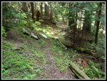
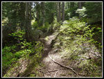
All to soon I packed up and headed back. It is a fairly long trip to Tuscohatchie but I met several groups coming in. I passed Pratt Lake and hiked through the forest to the start of the climb to the ridge top. At the long hidden junction with the old trail I stopped to take out my GPS. Within 25 feet of the new trail the old tread was easily found. There are some patches of devils club growing in it now. Without their new leaves they were easy to get through. Might be tougher in the summer. I found old puncheon boardwalks that were rotting aways. It had been probably 15 years since My last hike on this section of trail. There was a little snow higher up and I lost the route. Rather than keep hunting around I saw that the route went off tot he left and then back. I just went straight up easy open slopes until I found it again. The junction with the new trail is well concealed. From thee it was just a few switchbacks to the ridge top.
High clouds had moved in and it was warm but not at all hot for my hike down. So nice I hiked slower than usual to lengthen the time on trail. I met four or five groups while heading down but really not that many for such a nice day. I'm sure all the trails to summit views were mobbed this day. A nice long walk to multiple lakes was not. I finally reached the trailhead at about 5:20 pm. I was a great day on the trail. I spent an hour at a big mountain lake with complete solitude. I found the upper start of the Pratt Valley trail. I even hiked the abandoned section of the Pratt Lake trail for the first time in a long time. All in all, a great day for a hike.
Click on thumbnails to get
larger pictures.
Trips - 2013
Home
A moderate display of flowers greeted me along the Pratt Lake trail. Vanilla Leaf, plus some trillium, and yellow violets. I did find a blooming wild ginger on the way back. The creeks were no trouble to cross with dry feet in the morning and also in the afternoon. There is not much snow left to melt on the south side of Granite Mountain. I met a few groups coming out and one faster duo with light packs and tennis shoes They did just fine on the snow above.
The trail was snow free to the Talapus/Olallie junction. Just a few minutes farther along snow covered the trail. It was well compacted and only a foot or so deep. After a few tenths of a mile I was surprised as the trail reverted to dirt. Only in the last few tenths before the Olallie inlet creek crossing did snow reappear. It was several feet deep near the crossing but the crossing itself is snow free. More snow on the other side as the trail is in the open. When it shortly goes back into forest the snow disappeared It was bare all the way to the Pratt Lake junction and beyond. At the Olallie Lake/Mt. Rainier viewpoint I could see snow all around the lake. Mt. Rainier was cloud free. I still expected snow on the north side of the ridge. I was wrong.
The junction was snow free. I started down a bare trail on the north side. No snow at 4200' on a shaded north slope in mid June? Much less snow that the past few years. There were a few small snow patches in the forest. Very few. I brought gaiters and never bothered to put them on. Down lower the trail leaves forest. There were some sizable snow patches there. The danger was not sliding or losing the route. It was just post holing over talus fields. After a longer snow section it was bare dirt and rock once again. The night before I checked the map on my GPS. It included the Pratt Valley trail and to my surprise it had a dashed line for the old Pratt Lake trail down from the ridge. I hiked that many times before th longer route was opened. The top was not obvious even with the map and GPS. The bottom junction I knew well. Perhaps I could return on a shorter route without any snow?
When the trail grade flattened snow patches returned. None very deep. They will be gone in a week or two. There were plenty of tracks in the snow. Lots of folks have been down to the lakes already this year. After what seemed like a long time the trail finally reached Pratt Lake. No snow was seen from this point on. The trail is in fine shape. One downed log before the lake. That was it for the whole day except for a big log across the trail near Lower Tuscohatchie Lake. That one has been there for a decade. The trail along the lake is plastered with trillium and yellow violets. They line the trail all the way along the lake. One of the best displays of those two I have seen. I stopped to talk with one returning hiker at Pratt who had easily found the start of the Pratt Valley trail. That was a good sign.
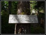
At the end of the lake I dropped down to the outlet. There were two groups at the lake already. I knew the trail was on the other side of the outlet creek. The creek is very wide at the end of the lake. One log jam required a big jump to get from log to log in the middle. I went farther down to another log jam. This one worked. On the other side I found a wall of slide alder. Many cuts and a quantity of blood later I fought my way through. I headed downstream and shortly found the trail. A sign announces "PRATT LK. TR. NO. 1007 - M. FK. SNOQUALMIE R. 10 - TR. NOT MAINTAINED". In fact, at least the start of the trail is in fine shape. I followed it for .50 miles finding many very old cuts of logs. I have now done all of the 20+ miles of the trail from I-90 to the Middle Fork Snoqualmie River trailhead except for about 7.5 miles in the middle. I will have to rectify that soon.
I followed the trail back up to the outlet creek and found that large flat rocks spanned the creek here. I easily crossed with no more blood shed. The trail continued on the other side right back to the main trail. It was still only 12:30 pm so I turned left and continued on towards Lower Tuscohatchie Lake. Lots more trillium and violets along here. Add in a huge number of marsh marigolds in bloom and a few glacier lilies. In short order I arrived at Lower Tuscohatchie Lake. I was the only person at the lake outlet. I crossed the bridge to the site of the old shelter. At the next outlet creek crossing I climbed up onto a big rock on the lake shore. A fine spot to enjoy the lake. I spent nearly an hour there. It was still very sunny but a cool breeze blew across the lake. A perfect place to enjoy a beautiful late spring day.
All to soon I packed up and headed back. It is a fairly long trip to Tuscohatchie but I met several groups coming in. I passed Pratt Lake and hiked through the forest to the start of the climb to the ridge top. At the long hidden junction with the old trail I stopped to take out my GPS. Within 25 feet of the new trail the old tread was easily found. There are some patches of devils club growing in it now. Without their new leaves they were easy to get through. Might be tougher in the summer. I found old puncheon boardwalks that were rotting aways. It had been probably 15 years since My last hike on this section of trail. There was a little snow higher up and I lost the route. Rather than keep hunting around I saw that the route went off tot he left and then back. I just went straight up easy open slopes until I found it again. The junction with the new trail is well concealed. From thee it was just a few switchbacks to the ridge top.
High clouds had moved in and it was warm but not at all hot for my hike down. So nice I hiked slower than usual to lengthen the time on trail. I met four or five groups while heading down but really not that many for such a nice day. I'm sure all the trails to summit views were mobbed this day. A nice long walk to multiple lakes was not. I finally reached the trailhead at about 5:20 pm. I was a great day on the trail. I spent an hour at a big mountain lake with complete solitude. I found the upper start of the Pratt Valley trail. I even hiked the abandoned section of the Pratt Lake trail for the first time in a long time. All in all, a great day for a hike.
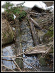
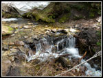
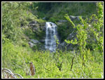 First Waterfall |
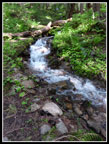 Cascading Creek |
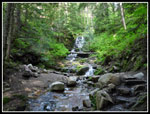 Another Waterfall |
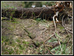
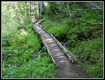 Long Boardwalk |
 On Snow |
 Clear View Of Rainier |
 Snow Above Pratt Lake |
 Mountain View |
 More Snow Near Lake |
 Blooming Trillium |
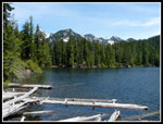
 Pratt Lake In Sight |
 Big Trillium Patch |
 Along Pratt Lake |
 Trail Greenery |
 Still More Trillium |
 Pratt From Outlet |
 Crossing Outlet |
 Old Trail Sign |
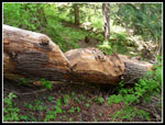
 Old Cut Log |
 Pratt River Trail |
 Hacked Up Log |
 Easy Creek Crossing |
 Snowy Peaks |
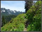 Green Along Trail |
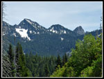
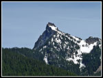 Kaleetan Peak |
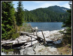 Bridge Over Outlet |
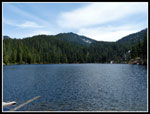
 Tuscohatchie Lake |
 Lunch View |
 One Perfect Trillium |
 Marsh Marigolds |
 Yellow Violet |
 Maybe More Perfect |
 Pratt River Valley |
 False Hellebore |
 Snow Above Pratt |
 Old Pratt Trail |
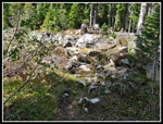
 Rotting Boardwalk |
 Boardless Boardwalk |
 Olallie Lake |
 Back On Snow |
 Olallie Inlet Creek |
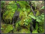 Bright Green Moss |
Trips - 2013
Home