5-31-14
Gary
was free and we planned a trip
to Merritt Lake east of Stevens Pass. After the lake was up in the air.
Gary suggested Point 5928 northeast of the lake. We figured to head
that way and adjust our plan as we went. We met in Bothell at 7:00 am
and headed east. Over Stevens Pass and 11 miles down the east side to
the signed road to the trailhead. The dirt road was in good shape and
my sedan had no trouble. We were the second car at the 3100' trailhead
when
we arrived at 8:30 am. By 8:45 we were on the trail. It was already
shorts and short sleeve weather. A trail report on the trailhead board
from a week earlier mentioned that snow started at 1.5 miles. Merritt
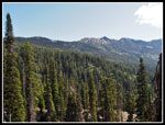
Lake is at 3.0 miles. We headed up the trail under blue sky with
perfect hiking conditions.
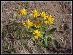
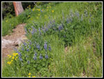
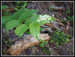
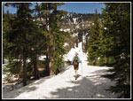
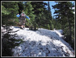
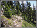
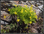
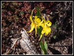
The wildflower show was pretty good down low. We saw lupine, penstemon, desert parsley, trillium, and more. This was a rare trip where neither Gary nor I had ever been on any part of the trip. We had both done numerous trips on Nason Ridge but not this part. The trail is very evenly graded. Never steep but never flat either. It made for easy hiking. Only the wildflower photos slowed us down. Numerous switchbacks helped us gain elevation without any steep grades. We had heavier boots and ice axes for the expected snow but with no snowshoes or crampons our pack weights were not bad. Right on schedule, we hit snow at about 1.5 miles and 4300'. Completely bare then a few patches then complete snow coverage almost immediately. We each brought a GPS unit to help with navigation on snow. With a few way points it also helps to list snow level and other features in my trip reports.
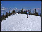
The snow was thinner at first and we did a little post holing. It was well consolidated and as the snow deepened the going was easier. There were recent footprints though it was not a problem if we lost them. We periodically looked at the GPS and moved over to near the summer trail position. As we neared Merritt Lake we looked to cross the outlet creek. It was mostly covered with snow. As we looked for a solid spot Gary noticed a person across the creek. We headed over and met one of two backpackers who came up the day before. They did not find the lake at first and set up camp. We could see that we were only a tenth of a mile or so away. After saying "hi" we soon covered the short distance to the lake.
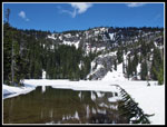
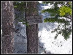
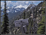
The lake is still snow covered. Snow depth is about 2-4 feet deep. We briefly considered heading for Mt. Mastiff but neither of us had done it on snow from Merritt Lake. On the way up we had a look out to Nason Ridge. Farther east it was out of forest and snow free. Just maybe we could make it to bare dirt and then on to Alpine Lookout. We quickly decided to follow the route of the Nason Ridge Trail to the east. With our GPS units we had no trouble climbing above the lake and finding the sign for the Nason Ridge Trail. This is at the point where the boot path to Lost Lake heads off. We turned east and the ridge immediately began to descend. We dropped down to a point where we stopped for sun screen. It was about 11:15 am already.
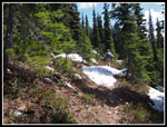
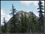
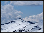
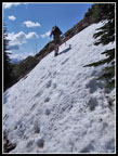
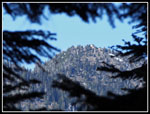
We dropped a little further to a saddle and began to climb. Gary did a great job of staying on the route of the summer trail. In places we found cut logs above the snow to verify our accuracy. We did not want to find the snow ended and we had to traverse a steep slope with no trail in sight. That was never a problem. We began to get a few small views out between the trees. In a few places there was a little bare dirt. There were no signs of footprints. Who would hike along the ridge towards Alpine Lookout when there is a shorter route with less elevation gain starting at the east end of the ridge? We would. We stopped to check out where we were. There were two high bumps on the ridge ahead. One was rounded and the other rocky. We thought the first one might be Point 5928. Nope.
The map and GPS showed that Point 5928 was just behind and above us. Should we climb on up and call it a day? Well, no. We chose to drop down and climb up towards those two points ahead. If the snow ended we would continue on towards Alpine Lookout. If not, we could climb up one or both of those points. We dropped down to another saddle then climbed up. The snow began to thin. Bare patches alternated with snow. Soon the snow was almost gone.
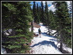
That settled it. Onwards to Alpine Lookout. The snow free trail was narrow on a steep hillside. It was not the easiest trail to hike but it was much easier than on snow. More wildflowers on the open slope. Though it was only in the mid to upper 60s with the sun on snow and now little shade it felt very hot. The route had several downhill stretches too. We did not seem to be climbing towards the 6237' lookout. Also, the two points on the ridge blocked our view of the lookout. We did not see it until almost there. At a steep snowfield across the trail we took out our ice axes. I was glad to have it. There was another one just after. We had already put away our axes and chose to climb above the snow. On the way back we used axes to cross both snow slopes. At a small patch of shade we stopped for lunch. We were 600' directly beneath the lookout. It was 1:30 p and we were three quarters of a mile away.
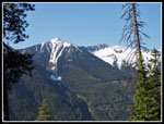
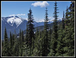
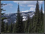
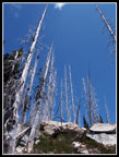
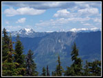
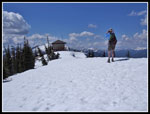
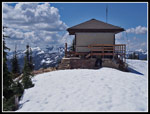
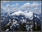
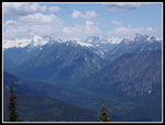
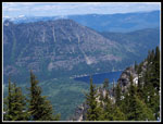
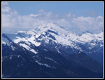
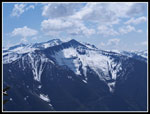
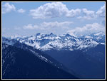
I felt much better after lunch. We ground out the last climb up to the junction with the spur trail to the lookout. On the last traverse to the top we reached another big snowfield. We headed straight up mostly on dirt. Near the ridge top we saw a solar panel. We followed the snowy crest over to the lookout. Old guide books had photos of a somewhat run down lookout. It is now in pristine shape. After the hike I checked photos from trip reports and figured out that it was a flat roofed lookout without a walkway in 2006. By 2010 it had a new pyramid roof, new paint, and a walkway around the building. It looks great. We arrived at 2:10 pm. It was too long a hike to just turn around. We spent about an hour on top. Great views in all directions. The late afternoon sun provided some haze but the views were still excellent. Mt. Stuart, Mt, Rainier, the Chiwaukums, Daniel and Hinman to the south. Rock, Howard, and Mastiff, on Nason Ridge to the west. The Monte Cristos, the bottom of Sloan Peak, Glacier Peak, Mt. David, Dirty Face, and Mt. Maude to the north west and north. A great viewpoint.
All too soon it was time to head back. At 3:15 pm we were on the trail down. Those uphills on the way back were not pleasant. It was cooler once we were back in forest and on snow. The snow was still pretty firm. Very little post holing. Near the lake we chose to go cross country rather than climb back up to the Lost Lake junction. That saved about a quarter mile and 100' of elevation gain. Near the lake we heard a loud gunshot. It was very close by. Since we were not on trail. it was a bit disconcerting. Would the shooters realize there were hikers around? Back at the lake we met the folks who camped just below the lake. They had the gun and were not shooting it into the forest. Just into the lake. After a short break we tackled the last 3 miles. It went pretty fast. We were getting a little tired. We finally reached the car at 7:10 pm.
Ten + hours is a long day hike for us. We traveled 12.4 miles with about 4300' of elevation gain and loss. About half of the trip was on snow. It turned out to be a great trip. A new trail for both of us. One snow covered lake. A long walk on or below a ridge, good company, and near total solitude. Finally, we reached a fire lookout with spectacular views. It was a long strenuous day that was well worth the effort. The mosquitoes are out. Not as bad as most trip reports mention in the summer but they were found even on the snow. I'm glad to get this one done when they are at least manageable.
Click on thumbnails to get
larger pictures.
Trips - 2014
Home
The wildflower show was pretty good down low. We saw lupine, penstemon, desert parsley, trillium, and more. This was a rare trip where neither Gary nor I had ever been on any part of the trip. We had both done numerous trips on Nason Ridge but not this part. The trail is very evenly graded. Never steep but never flat either. It made for easy hiking. Only the wildflower photos slowed us down. Numerous switchbacks helped us gain elevation without any steep grades. We had heavier boots and ice axes for the expected snow but with no snowshoes or crampons our pack weights were not bad. Right on schedule, we hit snow at about 1.5 miles and 4300'. Completely bare then a few patches then complete snow coverage almost immediately. We each brought a GPS unit to help with navigation on snow. With a few way points it also helps to list snow level and other features in my trip reports.
The snow was thinner at first and we did a little post holing. It was well consolidated and as the snow deepened the going was easier. There were recent footprints though it was not a problem if we lost them. We periodically looked at the GPS and moved over to near the summer trail position. As we neared Merritt Lake we looked to cross the outlet creek. It was mostly covered with snow. As we looked for a solid spot Gary noticed a person across the creek. We headed over and met one of two backpackers who came up the day before. They did not find the lake at first and set up camp. We could see that we were only a tenth of a mile or so away. After saying "hi" we soon covered the short distance to the lake.
The lake is still snow covered. Snow depth is about 2-4 feet deep. We briefly considered heading for Mt. Mastiff but neither of us had done it on snow from Merritt Lake. On the way up we had a look out to Nason Ridge. Farther east it was out of forest and snow free. Just maybe we could make it to bare dirt and then on to Alpine Lookout. We quickly decided to follow the route of the Nason Ridge Trail to the east. With our GPS units we had no trouble climbing above the lake and finding the sign for the Nason Ridge Trail. This is at the point where the boot path to Lost Lake heads off. We turned east and the ridge immediately began to descend. We dropped down to a point where we stopped for sun screen. It was about 11:15 am already.
We dropped a little further to a saddle and began to climb. Gary did a great job of staying on the route of the summer trail. In places we found cut logs above the snow to verify our accuracy. We did not want to find the snow ended and we had to traverse a steep slope with no trail in sight. That was never a problem. We began to get a few small views out between the trees. In a few places there was a little bare dirt. There were no signs of footprints. Who would hike along the ridge towards Alpine Lookout when there is a shorter route with less elevation gain starting at the east end of the ridge? We would. We stopped to check out where we were. There were two high bumps on the ridge ahead. One was rounded and the other rocky. We thought the first one might be Point 5928. Nope.
The map and GPS showed that Point 5928 was just behind and above us. Should we climb on up and call it a day? Well, no. We chose to drop down and climb up towards those two points ahead. If the snow ended we would continue on towards Alpine Lookout. If not, we could climb up one or both of those points. We dropped down to another saddle then climbed up. The snow began to thin. Bare patches alternated with snow. Soon the snow was almost gone.
That settled it. Onwards to Alpine Lookout. The snow free trail was narrow on a steep hillside. It was not the easiest trail to hike but it was much easier than on snow. More wildflowers on the open slope. Though it was only in the mid to upper 60s with the sun on snow and now little shade it felt very hot. The route had several downhill stretches too. We did not seem to be climbing towards the 6237' lookout. Also, the two points on the ridge blocked our view of the lookout. We did not see it until almost there. At a steep snowfield across the trail we took out our ice axes. I was glad to have it. There was another one just after. We had already put away our axes and chose to climb above the snow. On the way back we used axes to cross both snow slopes. At a small patch of shade we stopped for lunch. We were 600' directly beneath the lookout. It was 1:30 p and we were three quarters of a mile away.
I felt much better after lunch. We ground out the last climb up to the junction with the spur trail to the lookout. On the last traverse to the top we reached another big snowfield. We headed straight up mostly on dirt. Near the ridge top we saw a solar panel. We followed the snowy crest over to the lookout. Old guide books had photos of a somewhat run down lookout. It is now in pristine shape. After the hike I checked photos from trip reports and figured out that it was a flat roofed lookout without a walkway in 2006. By 2010 it had a new pyramid roof, new paint, and a walkway around the building. It looks great. We arrived at 2:10 pm. It was too long a hike to just turn around. We spent about an hour on top. Great views in all directions. The late afternoon sun provided some haze but the views were still excellent. Mt. Stuart, Mt, Rainier, the Chiwaukums, Daniel and Hinman to the south. Rock, Howard, and Mastiff, on Nason Ridge to the west. The Monte Cristos, the bottom of Sloan Peak, Glacier Peak, Mt. David, Dirty Face, and Mt. Maude to the north west and north. A great viewpoint.
All too soon it was time to head back. At 3:15 pm we were on the trail down. Those uphills on the way back were not pleasant. It was cooler once we were back in forest and on snow. The snow was still pretty firm. Very little post holing. Near the lake we chose to go cross country rather than climb back up to the Lost Lake junction. That saved about a quarter mile and 100' of elevation gain. Near the lake we heard a loud gunshot. It was very close by. Since we were not on trail. it was a bit disconcerting. Would the shooters realize there were hikers around? Back at the lake we met the folks who camped just below the lake. They had the gun and were not shooting it into the forest. Just into the lake. After a short break we tackled the last 3 miles. It went pretty fast. We were getting a little tired. We finally reached the car at 7:10 pm.
Ten + hours is a long day hike for us. We traveled 12.4 miles with about 4300' of elevation gain and loss. About half of the trip was on snow. It turned out to be a great trip. A new trail for both of us. One snow covered lake. A long walk on or below a ridge, good company, and near total solitude. Finally, we reached a fire lookout with spectacular views. It was a long strenuous day that was well worth the effort. The mosquitoes are out. Not as bad as most trip reports mention in the summer but they were found even on the snow. I'm glad to get this one done when they are at least manageable.
 Early View South |
 Wildflowers |
 Lupine |
 False Solomon's Seal |
 Nason Ridge |
 Gary Nears Lake |
 Merritt Lake |
 Sign At Junction |
 Lots Of Snow On Trail |
 Partly Bare Trail |
 Views To The South |
 More Ridge Snow |
 Rock Mountain |
 Silver Forest |
 Points On Ridge |
 First View North |
 Bare Trail At Last |
 More Wildflowers |
 Summit Junction |
 Lookout In Sight |
 Alpine Lookout |
 Howard & Mastiff |
 Napeequa Valley |
 Dirty Face Peak |
 Glacier Peak |
 Mt. Howard |
 Chiwaukum Mountains |
 Peaks To The South |
 Leaving Summit |
 Glacier Lilies |
 10 Mile Marker |
 Crossing Snow Slope |
 Zoom Of Summit |
Trips - 2014
Home