8-23-14
I
had been meaning to explore this trail for years. Back in the early
1990s I hiked the old railroad grade and found a boot path heading up.
It was very narrow on a very steep hillside. I went up a few
switchbacks and gave up. It appeared to be a way for climbers to hike
down after climbing the nearby wall. Six or seven years ago I read
reports of this now being a trail that connected to the old Great Wall
route up Mt. Washington. I planned to check it out sometime. Fast
forwards half a dozen years and the time had come. I needed to be home
by mid afternoon and chose this close in hike. There were four or five
cars in the lot at the trailhead just off the Exit 38 ramp. The access
road is in serious need of regrading. I was on my way by the not so
early hour of 8:15 am. It was much warmer than I was expecting.
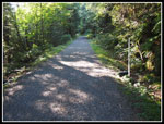
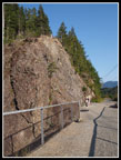
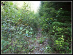
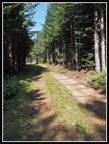
Up the trail to the access road then to the Iron Horse trail. Other than this short bit the trip would be a loop. I turned left and headed along the grade. The route crosses Change creek on a trestle and reaches the climbing area. There were several groups already climbing. Past that a ways is a section with a railing on each side. The trail begins by going behind the railing. It immediately looked much different than the narrow scramble route I was in some 15 - 20 years earlier. This is a real trail. Not particularly wide but plenty wide for one person to hike. Lots of moderately steep switchbacks at first and for much of the way up. This trail gains elevation very consistently.
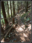
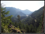
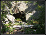
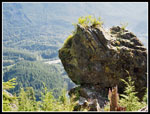
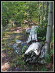
The humidity was way above western Washington levels. I was quickly soaked with sweat pouring down my face. At least I was in the shade. Most of the lower part is in forest. To the right is a near vertical rock wall. To the left is the valley of Hall Creek. The trail climbs with very short switchbacks up a narrow forested slope. In time some views open up. On is down to the waterfall on Hall Creek. It is not very large this time of year. One switchback goes by Whitebark's Bivouac. It is a small depression in the rock wall. At one point there is a big rock perched on the edge of the slope. It looks like one big kick and it's in the SF Snoqualmie River.Well, maybe a kick and a little dynamite. I kept looking up for the tip of the ridge and it did not seem to be coming. Eventually a flat ridge was just above.
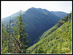
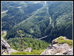
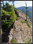
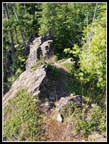
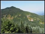
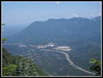
My GPS map showed a fairly flat ridge jutting out to the north. I took the side trail marked " Ollalie Point. The ridge is fairly level but not wide or flat. In two places it is more of a knife edge. The drop on both sides is enormous. Falling is not an option. After the narrow spots the ridge does widen. Near the end is a big flat area. Views are east and north to Mt. Defiance, and peaks along that ridge. Down is the Hall Creek Trestle on the railroad grade. It was a hazy morning and photos were not as clear as anticipated. I'll just have to come back. The detour took much longer than I expected. The good news is that high on the ridge the humidity had dropped significantly. There was still no breeze at all but it was much less muggy.
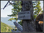
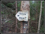
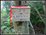
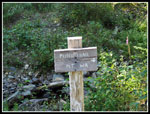
The trail now followed the ridge at a less steep grade. Still more switchbacks but my pace picked up. Just past Ollalie Point is Change Ck. Vista. this view is more to the west and north. It is almost on the trail. More climbing brought me to another sign. This one is for Hall Point. A short minute or two climb goes to an open spot on the ridge top. Some very nice views here. Back on trail the route soon begins to traverse below the ridge top. It reaches the end of an old logging spur. The grade is a bit overgrown but not too badly. It had rained the previous afternoon and a heavy dew left shaded brush wet. Everything in the sun was dry. I got a little wet but the shade was refreshing. Another junction goes to a viewpoint named J's Landing. This one I passed by for another visit. A sign near the start of the Change Creek Trail listed Mt. Washington as 6 miles away. I still had a long ways to go.
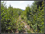
The route passed a bench and crossed Change Creek where it was in a culvert. It began to head north. I came to another junction I read about in a trip report. It is marked "Short Cut" and just cuts off a spot where the road continues then switches back. I wanted to hike the whole trail so opted for the long cut. Not a smart move. The old road/trail immediately became brushier. The farther I went the brushier it was. After the switchback I could no longer see the ground through the thick brush. I picked up a number of cuts here. The thought of another mile or more of this was disheartening. I was just pushing through slide alder at one point. Right at the worst of it I came to the end of the "Short Cut". The route magically improved a whole lot. The moral is that unless someone does some serious brushing, the Short Cut is the route to take.
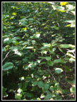
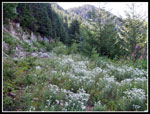
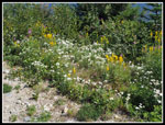
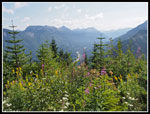
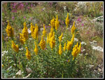
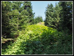
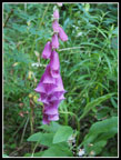
It was still brushy but not too bad. The only draw back was the dampness soaking my shorts. As expected, once I was out of the brush they dried fast. The route headed up the valley of Change Creek. I knew there was a pond up there. I came to a sign that said "Pond" with "Mt WA" right below it. An arrow between them pointed to the right. Now, was the pond up the valley at the head or on the short cut trail than cut off the walk up the rest of the valley? I guessed it was straight ahead up the valley. I guessed wrong. I walked on and on in wet brush. Not thick enough to impair progress but thick enough to really soak my shorts. At the end of the valley the route switched back and began to head north. No pond. I followed the old road as the brush lessened and became mostly fireweed, foxglove, and pearly everlasting. Lots of wildflower color.
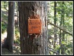
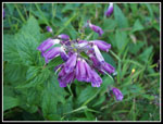
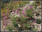
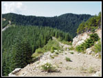
In time I reached a small sign. It said "Pond". That settled where the pond was. The trail there was invisible. I did not drop down to look for it. I'd guess some brushing is in order. Now i was mostly in the late morning sun and it was getting very hot. The trail is very sketchy here. Not hard to walk but with not much of a path. It looks like not a lot of folks continue on to Mt. Washington. At long last I reached the junction with the road to the Great Wall and Mt. Washington. I have hiked that route many times though not recently. The road was much brushier than I had ever seen it. It is getting to be more a trail than a wide road in spots. I found one patch of Indian paintbrush mixed in with pearly everlasting. Bright red and white together. Some good views to the east and north here though the haze did not help.
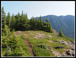
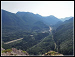
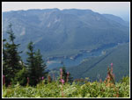
I soon crossed the Great Wall and began to hike the ridge top road along the Seattle watershed boundary. I reached the junction with the route up to the summit of Mt. Washington and met two hikers. They had come up Change Creek the evening before and camped near the pond. the first people I had seen since the climbers along the railroad grade. The lower part of the route up was brushy as expected. Not many folks hike it any more. When I reached the new trail junction the route became much better. Mt. Rainier was completely lost in the haze. Chester Morse Lake was a bit hazy but clearly visible right below. A few minutes later I reached the summit. A group was just packing up to head down. I soon had the summit to myself.
It was 12:15 pm when I reached the top. With side trips, lots of photos, and the steep lower trail it took me 4 hours to hike up 7 miles. Not a very fast pace. The views were hazy and my goal to get home early was in tatters so I only stayed on top for 15 minutes. Another group arrived as I left. I met two more groups just below the top. The hike down was much faster. Seven miles up but only four miles back down. I passed several groups heading down and 6 or 7 heading up. Less than I expected on a sunny summer Saturday. I dropped to the railroad grade and within several minutes I completed the loop. Back at the parking lot most all the spaces were filled. I reached my car at 2:12 pm. 1:42 is not such a bad time to descend.
All in all, I liked the full loop trip. Much more interesting than just going up and down Mt. Washington. As expected, six miles of the loop had total solitude. Change Creek is a steep trail but it does get you up high fast. some nice viewpoints along the way. Ollalie Point is fine for folks comfortable scrambling with some exposure. Turn around if you are not comfortable. You get a lot of the view before the short knife edge spots. I now know to take the "Short Cut" to avoid some bleeding and to take a right to see the pond. Other than that "Pond" sign the signage is excellent. I'm sure I'll be back to do the loop again soon.
Click on thumbnails to get
larger pictures.
Trips - 2014
Home
Up the trail to the access road then to the Iron Horse trail. Other than this short bit the trip would be a loop. I turned left and headed along the grade. The route crosses Change creek on a trestle and reaches the climbing area. There were several groups already climbing. Past that a ways is a section with a railing on each side. The trail begins by going behind the railing. It immediately looked much different than the narrow scramble route I was in some 15 - 20 years earlier. This is a real trail. Not particularly wide but plenty wide for one person to hike. Lots of moderately steep switchbacks at first and for much of the way up. This trail gains elevation very consistently.
The humidity was way above western Washington levels. I was quickly soaked with sweat pouring down my face. At least I was in the shade. Most of the lower part is in forest. To the right is a near vertical rock wall. To the left is the valley of Hall Creek. The trail climbs with very short switchbacks up a narrow forested slope. In time some views open up. On is down to the waterfall on Hall Creek. It is not very large this time of year. One switchback goes by Whitebark's Bivouac. It is a small depression in the rock wall. At one point there is a big rock perched on the edge of the slope. It looks like one big kick and it's in the SF Snoqualmie River.Well, maybe a kick and a little dynamite. I kept looking up for the tip of the ridge and it did not seem to be coming. Eventually a flat ridge was just above.
My GPS map showed a fairly flat ridge jutting out to the north. I took the side trail marked " Ollalie Point. The ridge is fairly level but not wide or flat. In two places it is more of a knife edge. The drop on both sides is enormous. Falling is not an option. After the narrow spots the ridge does widen. Near the end is a big flat area. Views are east and north to Mt. Defiance, and peaks along that ridge. Down is the Hall Creek Trestle on the railroad grade. It was a hazy morning and photos were not as clear as anticipated. I'll just have to come back. The detour took much longer than I expected. The good news is that high on the ridge the humidity had dropped significantly. There was still no breeze at all but it was much less muggy.
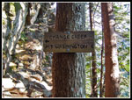
The trail now followed the ridge at a less steep grade. Still more switchbacks but my pace picked up. Just past Ollalie Point is Change Ck. Vista. this view is more to the west and north. It is almost on the trail. More climbing brought me to another sign. This one is for Hall Point. A short minute or two climb goes to an open spot on the ridge top. Some very nice views here. Back on trail the route soon begins to traverse below the ridge top. It reaches the end of an old logging spur. The grade is a bit overgrown but not too badly. It had rained the previous afternoon and a heavy dew left shaded brush wet. Everything in the sun was dry. I got a little wet but the shade was refreshing. Another junction goes to a viewpoint named J's Landing. This one I passed by for another visit. A sign near the start of the Change Creek Trail listed Mt. Washington as 6 miles away. I still had a long ways to go.
The route passed a bench and crossed Change Creek where it was in a culvert. It began to head north. I came to another junction I read about in a trip report. It is marked "Short Cut" and just cuts off a spot where the road continues then switches back. I wanted to hike the whole trail so opted for the long cut. Not a smart move. The old road/trail immediately became brushier. The farther I went the brushier it was. After the switchback I could no longer see the ground through the thick brush. I picked up a number of cuts here. The thought of another mile or more of this was disheartening. I was just pushing through slide alder at one point. Right at the worst of it I came to the end of the "Short Cut". The route magically improved a whole lot. The moral is that unless someone does some serious brushing, the Short Cut is the route to take.
It was still brushy but not too bad. The only draw back was the dampness soaking my shorts. As expected, once I was out of the brush they dried fast. The route headed up the valley of Change Creek. I knew there was a pond up there. I came to a sign that said "Pond" with "Mt WA" right below it. An arrow between them pointed to the right. Now, was the pond up the valley at the head or on the short cut trail than cut off the walk up the rest of the valley? I guessed it was straight ahead up the valley. I guessed wrong. I walked on and on in wet brush. Not thick enough to impair progress but thick enough to really soak my shorts. At the end of the valley the route switched back and began to head north. No pond. I followed the old road as the brush lessened and became mostly fireweed, foxglove, and pearly everlasting. Lots of wildflower color.
In time I reached a small sign. It said "Pond". That settled where the pond was. The trail there was invisible. I did not drop down to look for it. I'd guess some brushing is in order. Now i was mostly in the late morning sun and it was getting very hot. The trail is very sketchy here. Not hard to walk but with not much of a path. It looks like not a lot of folks continue on to Mt. Washington. At long last I reached the junction with the road to the Great Wall and Mt. Washington. I have hiked that route many times though not recently. The road was much brushier than I had ever seen it. It is getting to be more a trail than a wide road in spots. I found one patch of Indian paintbrush mixed in with pearly everlasting. Bright red and white together. Some good views to the east and north here though the haze did not help.
I soon crossed the Great Wall and began to hike the ridge top road along the Seattle watershed boundary. I reached the junction with the route up to the summit of Mt. Washington and met two hikers. They had come up Change Creek the evening before and camped near the pond. the first people I had seen since the climbers along the railroad grade. The lower part of the route up was brushy as expected. Not many folks hike it any more. When I reached the new trail junction the route became much better. Mt. Rainier was completely lost in the haze. Chester Morse Lake was a bit hazy but clearly visible right below. A few minutes later I reached the summit. A group was just packing up to head down. I soon had the summit to myself.
It was 12:15 pm when I reached the top. With side trips, lots of photos, and the steep lower trail it took me 4 hours to hike up 7 miles. Not a very fast pace. The views were hazy and my goal to get home early was in tatters so I only stayed on top for 15 minutes. Another group arrived as I left. I met two more groups just below the top. The hike down was much faster. Seven miles up but only four miles back down. I passed several groups heading down and 6 or 7 heading up. Less than I expected on a sunny summer Saturday. I dropped to the railroad grade and within several minutes I completed the loop. Back at the parking lot most all the spaces were filled. I reached my car at 2:12 pm. 1:42 is not such a bad time to descend.
All in all, I liked the full loop trip. Much more interesting than just going up and down Mt. Washington. As expected, six miles of the loop had total solitude. Change Creek is a steep trail but it does get you up high fast. some nice viewpoints along the way. Ollalie Point is fine for folks comfortable scrambling with some exposure. Turn around if you are not comfortable. You get a lot of the view before the short knife edge spots. I now know to take the "Short Cut" to avoid some bleeding and to take a right to see the pond. Other than that "Pond" sign the signage is excellent. I'm sure I'll be back to do the loop again soon.
 Iron Horse Trail |
 Rock Climbers |
 Heading Up Trail |
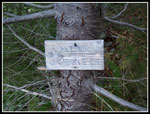
 6 Miles Of Uphill To Go |
 Views Out |
 Whitebark's Bivouac |
 Big Rock |
 Early Fall Color |
 Hall Creek Falls |
 Ollalie Point |
 Ollalie Pt Meadow |
 Ollalie Pt View East |
 Hall Creek Trestle |
 One Knife Edge Spot |
 Other Knife Edge Spot |
 Change Creek Vista |
 Hall Point Sign |
 J's Landing Junction |
 Bench Near Change Ck |
 Brushy Short Cut |
 Brush Relents |
 Right To Reach Pond |
 Indian Paintbrush |
 Pearly Everlasting |
 End Of Change Ck Trail |
 Nice Color |
 Brushy Road/Trail |
 Wildflowers |
 More Views |
 Fireweed |
 Goldenrod |
 The Great Wall |
 Mt. Washington |
 Ridge Top Road/Trail |
 More Brushy Trail |
 Chester Morse Lake |
 Hazy Summit View |
 Foxglove |
 Log Across Trail |
Trips - 2014
Home