5-17-14
Every
year for more than two decades I managed to hike up Iron Peak. Until
last year. I really wanted to get back for a spring snow scramble. Gwen
joined me for this trip. A report from just a few days earlier said
that the NF Teanaway Road was now open to the Iron Peak trailhead. That
is a short route to the summit. I like the longer and much more
lonesome route via Beverly Creek. We met at 7:00 am in Bellevue and
headed east. Overcast skies for most of the drive. Off the highway at
Cle Elum and up Highway 970 to the NF Teanaway Road. There were quite a
few folks camping at 29 Pines. The dirt road is pretty bad the first
mile. A lot of deep pot holes. After Stafford Creek it is not great but
much better. The water bars cut in the Beverly Creek Road are pretty
bad. No trouble for a Subaru. Would be not trouble for anyone without
the deep gouges cut into the road. We arrived at the 3630' trailhead at
about 9:00 am. There were half a dozen cars in the lot.
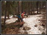
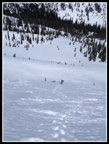
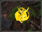
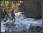
We were on our way by 9:15 am. The sky was white but I held out hope that the partial clearing in the forecast might still happen. On the drive in we noticed that the NF Teanaway River was very high. Beverly Creek was roaring too. The first part is on the old road. Along the side I saw far more blooming trillium than ever on this trail. There were a few glacier lilies too as the snow has only recently melted. In short order we reached Bean Creek. With the high water seen earlier we were not sure it would be safe to cross. Fortunately the creek has spread out into all channels. It is very wide but not as deep as it might have been. We put on water shoes and plunged across. I hate to have soaking feet the whole day and a little planning allowed us to put on dry socks and shoes.
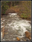
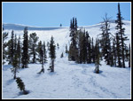
Beyond the creek was more bare dirt. At 4000' there was still no snow. When we entered forest a thin snow cover began immediately. It was a little slick but we did just fine with boots alone. It's nice to stay on the trail but not necessary. When forest is left the trail drops right by the creek. An easy place to get back on track. We managed to stay on the now mostly snow covered trail. In a few weeks it will bare through the forest. We took a break by the creek. It was really roaring.
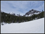
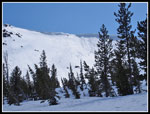
The trail was a mix of bare and snow covered in the mostly open valley. The summer trail switchbacks higher on the side of the valley. With snow cover it is much easier to stay nearer to the creek. The snow was not deep enough to be solid so we were often post holing down to dirt. The snow deepened as we hiked up the valley but was still much thinner than I was expecting. I have always been able to find a snow bridge across Beverly Creek. I was having some doubts for this day. Without a snow bridge it would mean climbing down the snow, crossing the creek, and climbing back up a vertical snow wall on the other side. Not so easy. As we hiked higher up the valley I made a miscalculation. I though we were getting near the summer trail crossing below Fourth Creek Pass. With all the trees I could not be sure. We found a spot where it was bare dirt on the creek edge. The creek was narrow, fast, and deep. There was an undercut wall of snow on the other side.
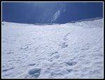
We debated and I put on my water booties. I slogged across, grabbed a small tree, and pulled myself up on the other side. Gwen came across and I helped pull her up. Not what I expected but we were across. Now began a traverse along the creek then more steeply up the slope towards the saddle between Iron and Teanaway Peaks. The snow was now much deeper and the going was easier. We sank in far enough to provide solid steps and there was minimal post holing. We had seen a little blue sky in places and now there was even more. Enough clouds overhead to keep the temperature down but more hopes of some clearing on the summit. Photos up to this point were mostly white snow and white sky.
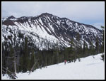
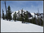
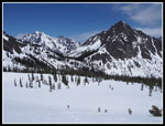
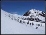
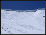
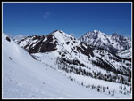
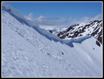
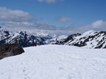
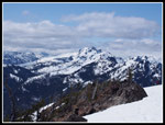
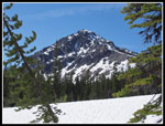
We made steady progress. The views improve with every step. Soon Volcanic Neck came into view behind us. Next was Bean Peak. Bill Peak went from a point high above to a peak across from us. The forest thins higher up improving the views even more. The best part is when Mt. Stuart comes into view framed by Bill and Teanaway Peaks. I have been here in these conditions more than a dozen times but it was a first for Gwen. All the snow highlighting the peaks makes for dramatically better views than in summer. We finally reached the flat area below the summit ridge of Iron Peak. The saddle was off to our right. The straight up slope to the ridge near the summit was closer on our left. The summit ridge has some enormous cornices. In fact, most of the ridge is corniced. There are a few spots that do not have cornices above. I have climbed up one spot on a number of occasions. The straight up spot would cut off a good chunk of distance. I stopped and laid out the options to Gwen. She was all for the short steep option.
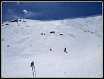
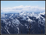
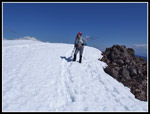
We could see a track going up there and an old ski track heading down. Thus far we had carried snowshoes all the way and that did not change. We never did put them on. Just a little extras training weight. The climb is about 400'+ in a fraction of a mile. I have glissaded down it in a matter of seconds. It would take a whole lot longer to get up it. I went ahead kicking steps. The old track was useless. I had to kick all new steps. On the bright side the snow conditions were great. Soft enough to get a solid step but firm enough not to break away. I had to make a number of short detours to keep from squishing a dozen or more big lady bugs on the snow in front of me. I have never seen that on a steep snow slope. Each time I looked up the ridge seemed to be just about the same distance away. I just stopped looking up. The views of Stuart, Teanaway, Bill, and the Stuart Range were outstanding. Looking at the huge cornices close up was impressive. Eventually we reached the ridge top not far from the summit.
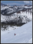
The wind had been very light in the valley. As we climbed to the summit ridge it picked up a bit. On the summit it was much harder. We headed over to the summit and bundled up. It was well past lunch time at 2:25 pm. A Mountaineers group was right behind us. They went up the shorter Iron Peak Trail and summited Teanaway Peak before heading over to Iron. Now on top, blue covered much of the sky. Rainier was hidden but otherwise we had terrific views. We spent about 40 minutes on top. Just after 3:00 pm we packed up and headed down. We debated going down our up route but chose to descend farther down the ridge. The snow seemed too soft to glissade. We followed the ridge down to the last big descent and on the flat area we went over to the edge. from higher up we were able to see that there were no cornices here. The slope was quite steep but with only about 150' down to gentler terrain.
I took off my convertible pants legs back at Bean Creek and decided to try a glissade in shorts. Much to my surprise I picked up some good speed on the soft snow. With an ice axe for a brake it was fine. Gwen followed and we were rapidly down the slope. From there it was great fun slogging downhill on good snow. We made good time down to the creek. We aimed high up the valley to try to find a spot with a solid snow bridge. Our planning paid off. We found a bridge that we could not poke a hole in and it was not far above the water if it failed. We crossed just fine. Now came a meandering trek through the forest as we headed down the valley. Lower in the valley we picked up our uphill tracks. The thin snow was now much softer. We had a lot more post holing than on the way up.
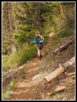
We took another break along the creek just before the trail enters the forest. A group we had seen at the trailhead now passed us. They had gone up Bean Creek to summit Bean, Volcanic Neck, Bean, and Mary Peaks. Back in forest the snow was firmer and the going much easier. I was not unhappy when we were off the snow for good. At Bean Creek, now with gaiter on, we just booted it across. In 10 minutes we would be back to dry socks at the car. A few runners were near the creek. They soon ran right by us. We were back at the car before 6:00 pm. For the day we saw nobody until the summit and two parties in the last few miles heading back. Yet another hike with near total solitude this spring. I love a spring snow scramble of Iron Peak and this trip did not let me down.
Gwen's report & photos are here: NWHikers Report
We were on our way by 9:15 am. The sky was white but I held out hope that the partial clearing in the forecast might still happen. On the drive in we noticed that the NF Teanaway River was very high. Beverly Creek was roaring too. The first part is on the old road. Along the side I saw far more blooming trillium than ever on this trail. There were a few glacier lilies too as the snow has only recently melted. In short order we reached Bean Creek. With the high water seen earlier we were not sure it would be safe to cross. Fortunately the creek has spread out into all channels. It is very wide but not as deep as it might have been. We put on water shoes and plunged across. I hate to have soaking feet the whole day and a little planning allowed us to put on dry socks and shoes.
Beyond the creek was more bare dirt. At 4000' there was still no snow. When we entered forest a thin snow cover began immediately. It was a little slick but we did just fine with boots alone. It's nice to stay on the trail but not necessary. When forest is left the trail drops right by the creek. An easy place to get back on track. We managed to stay on the now mostly snow covered trail. In a few weeks it will bare through the forest. We took a break by the creek. It was really roaring.
The trail was a mix of bare and snow covered in the mostly open valley. The summer trail switchbacks higher on the side of the valley. With snow cover it is much easier to stay nearer to the creek. The snow was not deep enough to be solid so we were often post holing down to dirt. The snow deepened as we hiked up the valley but was still much thinner than I was expecting. I have always been able to find a snow bridge across Beverly Creek. I was having some doubts for this day. Without a snow bridge it would mean climbing down the snow, crossing the creek, and climbing back up a vertical snow wall on the other side. Not so easy. As we hiked higher up the valley I made a miscalculation. I though we were getting near the summer trail crossing below Fourth Creek Pass. With all the trees I could not be sure. We found a spot where it was bare dirt on the creek edge. The creek was narrow, fast, and deep. There was an undercut wall of snow on the other side.
We debated and I put on my water booties. I slogged across, grabbed a small tree, and pulled myself up on the other side. Gwen came across and I helped pull her up. Not what I expected but we were across. Now began a traverse along the creek then more steeply up the slope towards the saddle between Iron and Teanaway Peaks. The snow was now much deeper and the going was easier. We sank in far enough to provide solid steps and there was minimal post holing. We had seen a little blue sky in places and now there was even more. Enough clouds overhead to keep the temperature down but more hopes of some clearing on the summit. Photos up to this point were mostly white snow and white sky.
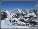
We made steady progress. The views improve with every step. Soon Volcanic Neck came into view behind us. Next was Bean Peak. Bill Peak went from a point high above to a peak across from us. The forest thins higher up improving the views even more. The best part is when Mt. Stuart comes into view framed by Bill and Teanaway Peaks. I have been here in these conditions more than a dozen times but it was a first for Gwen. All the snow highlighting the peaks makes for dramatically better views than in summer. We finally reached the flat area below the summit ridge of Iron Peak. The saddle was off to our right. The straight up slope to the ridge near the summit was closer on our left. The summit ridge has some enormous cornices. In fact, most of the ridge is corniced. There are a few spots that do not have cornices above. I have climbed up one spot on a number of occasions. The straight up spot would cut off a good chunk of distance. I stopped and laid out the options to Gwen. She was all for the short steep option.
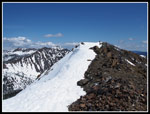
We could see a track going up there and an old ski track heading down. Thus far we had carried snowshoes all the way and that did not change. We never did put them on. Just a little extras training weight. The climb is about 400'+ in a fraction of a mile. I have glissaded down it in a matter of seconds. It would take a whole lot longer to get up it. I went ahead kicking steps. The old track was useless. I had to kick all new steps. On the bright side the snow conditions were great. Soft enough to get a solid step but firm enough not to break away. I had to make a number of short detours to keep from squishing a dozen or more big lady bugs on the snow in front of me. I have never seen that on a steep snow slope. Each time I looked up the ridge seemed to be just about the same distance away. I just stopped looking up. The views of Stuart, Teanaway, Bill, and the Stuart Range were outstanding. Looking at the huge cornices close up was impressive. Eventually we reached the ridge top not far from the summit.
The wind had been very light in the valley. As we climbed to the summit ridge it picked up a bit. On the summit it was much harder. We headed over to the summit and bundled up. It was well past lunch time at 2:25 pm. A Mountaineers group was right behind us. They went up the shorter Iron Peak Trail and summited Teanaway Peak before heading over to Iron. Now on top, blue covered much of the sky. Rainier was hidden but otherwise we had terrific views. We spent about 40 minutes on top. Just after 3:00 pm we packed up and headed down. We debated going down our up route but chose to descend farther down the ridge. The snow seemed too soft to glissade. We followed the ridge down to the last big descent and on the flat area we went over to the edge. from higher up we were able to see that there were no cornices here. The slope was quite steep but with only about 150' down to gentler terrain.
I took off my convertible pants legs back at Bean Creek and decided to try a glissade in shorts. Much to my surprise I picked up some good speed on the soft snow. With an ice axe for a brake it was fine. Gwen followed and we were rapidly down the slope. From there it was great fun slogging downhill on good snow. We made good time down to the creek. We aimed high up the valley to try to find a spot with a solid snow bridge. Our planning paid off. We found a bridge that we could not poke a hole in and it was not far above the water if it failed. We crossed just fine. Now came a meandering trek through the forest as we headed down the valley. Lower in the valley we picked up our uphill tracks. The thin snow was now much softer. We had a lot more post holing than on the way up.
We took another break along the creek just before the trail enters the forest. A group we had seen at the trailhead now passed us. They had gone up Bean Creek to summit Bean, Volcanic Neck, Bean, and Mary Peaks. Back in forest the snow was firmer and the going much easier. I was not unhappy when we were off the snow for good. At Bean Creek, now with gaiter on, we just booted it across. In 10 minutes we would be back to dry socks at the car. A few runners were near the creek. They soon ran right by us. We were back at the car before 6:00 pm. For the day we saw nobody until the summit and two parties in the last few miles heading back. Yet another hike with near total solitude this spring. I love a spring snow scramble of Iron Peak and this trip did not let me down.
Gwen's report & photos are here: NWHikers Report
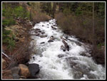 Beverly Creek |
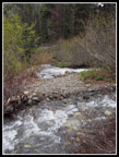 Bean Creek |
 Crossing Bean Creek |
 Bare Trail |
 On The Snow |
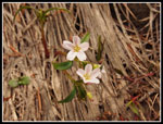 Spring Beauty |
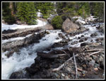 Along Beverly Creek |
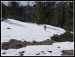 Snow & Some Dirt |
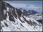
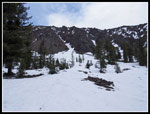 Gullies |
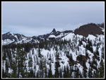
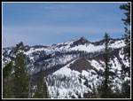
 Teanaway & Bill Peaks |
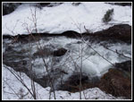 Crossing Beverly Creek |
 Volcanic Neck |
 Mary Peak |
 Teanaway Peak |
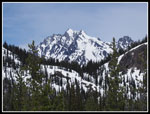 Mt. Stuart |
 Bean Peak |
 Stuart & Bill |
 Little Annapurna |
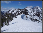
 That's Our Route Up |
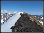
 Saddle On Ridge |
 Big Cornices |
 Aim For The Sky |
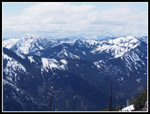
 View North |
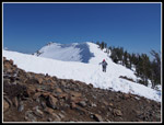
 Gwen Is Below |
 Mt. Daniel Over Ridge |
 Gwen Nears The Ridge |
 Ridge Top View |
 Summit Is Just Ahead |
 Mountaineers Approach |
 Hawkins Mountain |
 Jolly Mountain |
 Gwen At Iron Summit |
 Snoqualmie Pass Peaks |
 Leaving Summit |
 Hiking Ridge |
 Summit Still In Sight |
 Glissade Tracks |
 Uphill Tracks |
 Bill Peak |
 Glacier Lily |
 Gwen Crossing Bean |
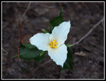 Trillium |
Trips - 2014
Home