4-12-14
In January of 2011 I hiked up McDonald
Mountain for the first time.
That day it was nearly snow free to the tower summit and I had snow on
the climb to the real summit. I had clouds below me and some sunshine
but also thick misty clouds dropping visibility to nearly zero. I
wanted to come back on a clear day to see all the views. This spring
day was more like than unlike that mid winter trip. This time I knew
the route though. I brought a GPS just in case but recognized all the
junctions and never turned it on. I had a fairly early start, leaving
north Seattle at 7:00 am . I headed down Highway 169 from Renton to the
Kent-Kangley Road and turned left. Continue straight until you reach
the mountains. The 960' elevation2300' blue gate is right at the sign
post for Kent Kangley and 346th Ave SE. There were already 4 other cars
parked there at 7:55 am.
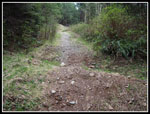
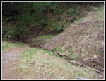
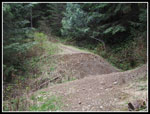
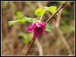
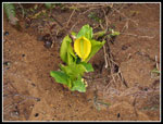
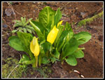
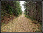
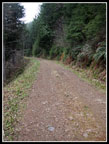
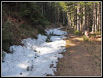
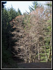
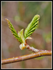
It was in the upper 40s when I started out but heading uphill I was warm enough with just a light long sleeve shirt. The first thing I recalled about my first visit was all the trenches that cross the road/trail down low. In the dozens of places where culverts were removed there is a drop and climb back up to the grade. Some of them are 10 to 15 feet deep. There are a lot of them. The route is looking more like a trail and less like a road since my earlier visit. Spring flowers are few and far between. I saw two skunk cabbage in bloom right along the trail. No spring beauty, trillium, yellow violets or bleeding heart. I did see a lot of coltsfoot in bloom. there were some salmonberry flowers as well. After nearly a mile the trenches stopped and the walking became much easier. I saw four high school aged kids coming down and one person below the trail digging something. That was it for the next 4 hours. I did see folks on the last few miles as I went down and they were coming up.
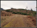
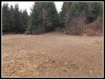
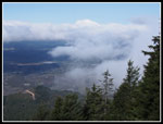
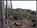
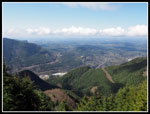
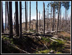
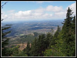
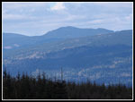
The road/trail leaves the forest and enters a big clear cut. On my 2011 visit I had no views here at all. This time I could see a little. One deep gap looked like the bottom of Rattlesnake Ledges. This was confirmed on the way back. I had much clearer views then. The road comes to a junction. Downhill right is another possible route up. Left soon goes downhill too. A left and a quick right turn is the correct route. I had some views off to the right along here. It was misty and hazy but I could see the lowlands to the west. The blue gate I soon reached was locked. Last time it was open. The road goes back into forest on the north side of the ridge. The temperature dropped about 15 degrees. I put gloves on. Quite a difference from the sunny section just below.
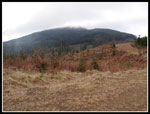
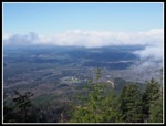
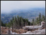
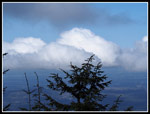
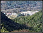
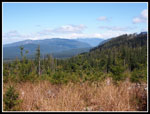
Soon I reached the old quarry site. The road splits. Straight ahead is a yellow gate that warns about entry into the Tacoma Watershed. The right fork heads uphill to another blue gate. This is the route to the tower site on the lower north summit. The road switches back and forth on the way up. I was surprised to see a little snow along the side of the road near the top. Just before the top is an old road heading off to the left. That's the route to the real summit. There was no snow at the 3284' tower site. I had some views out to the west but the clouds made it look much like my 2011 visit. Not as clear as I was expecting from the forecast. It's about 4.2 miles up with about 2300' of gain.
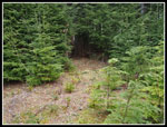
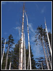
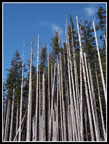
I took a few photos and was soon back on the move. Down from the tower to the first switchback where the old road turned off right and headed south down the ridge. This road is covered with spongy moss. Very easy walking. The road soon began to drop to a low point and then headed up. At the end of the road is the spot where in 2011 I had to push through closely spaced trees to get to the open forest beyond. No problem now. A path has been cut through the trees. Who ever has been doing maintenance has also cleared a foot path over to the road in the clear cut. The cut was fresh in 2011 and I climbed over many slash piles and down logs to reach the road. On the way back I followed the road to a point where I could more easily get back up to the path. Now the path continues all the way to the road in the cut. Some views out here though the clouds limited them.
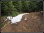
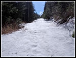
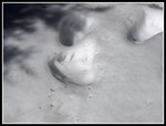
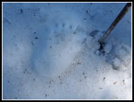
At the end of the road I went right around a pile of debris and in just about 20 feet I reached the next road. This one continues, with one junction, to the real summit of McDonald Mountain. This road too has not seen wheels in some time. Lots of grass growing in it. The road follows the ridge climbing and then descending. There are several saddles in the ridge that require descents and then climbs. Each drop is a climb on the way back. There are about 500' of downhill between the tower and the real summit. Although the real summit is only some 300' higher than the tower there is 1300' of gain round trip between them. On the steepest descent the road was snow covered. Only 4 to 6 inches deep but enough to soak my light trail shoes. At the last junction I turned right uphill for the last climb. On the January 2011 trip I also faced snow on the last descent. The deepest snow that day was on the climb to the summit. Part way up the snow began. Now I was sinking in 4-7 inches with every step. Not hard but tedious. I saw what appeared to be bear prints in the snow. As big as my hand with claw marks.
Near the top I left the road to the summit and followed animal tracks up the embankment and into forest. Maybe not such a good move. There was much less snow as I'd hoped in the forest but the trees were very closely spaced. It was not much fun working my way up the last bit. The 3570' top has even less views than three years ago. Trees growing back to the west are now tall enough to block some of the view. It was sunny though. I could see the middle peak near the clear cut and also the tower on the north peak. I arrived on top just after 11:00 am. Some photos and lunch and I headed back. The snowy road was much easier with my footprints in place. Back at the clear cut I had marginally better views. Still a lot of clouds. I stopped once again at the tower site. It was warmer in the sunshine. Going down I was back on the north side and it was dramatically colder in the shade. A cold north breeze was also blowing. Gloves went back on. It was better when the road swung around to the ridge top and I was back in sun. After passing the middle blue gate I met the first folks since early morning. Farther down I was to see a few more hikers and a number of mountain bikers.
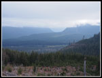
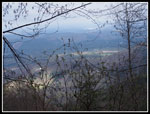
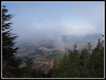
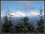
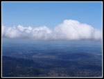
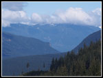
From the lower clear cut I could now see the peaks that were in the clouds in the morning. That was definitely Rattlesnake Ledges. Beyond were several cloudy peaks. At that angle that would be Mt. Si and Mt. Teneriffe. I could see all the towers along Rattlesnake Mountain and on Tiger Mountain too. This was a very unusual angle seeing the back side of those peaks. From there I went back into the forest for the last few miles. Back through the many ditches. They were much easier to cross going downhill. I made it back to the gate at 2:25 pm. Just about 6.5 hours in total. Many folks will not hike on a route composed mainly of old roads. I disagree. I had a great deal of solitude on a close in hike that totaled about 13 miles with 3600' of elevation gain. A little bit of route finding is necessary after the tower site but it's worth it to traverse the ridge all the way to the real summit. A fine day for a hike. I still need to come back again on a very clear day for all the views.
It was in the upper 40s when I started out but heading uphill I was warm enough with just a light long sleeve shirt. The first thing I recalled about my first visit was all the trenches that cross the road/trail down low. In the dozens of places where culverts were removed there is a drop and climb back up to the grade. Some of them are 10 to 15 feet deep. There are a lot of them. The route is looking more like a trail and less like a road since my earlier visit. Spring flowers are few and far between. I saw two skunk cabbage in bloom right along the trail. No spring beauty, trillium, yellow violets or bleeding heart. I did see a lot of coltsfoot in bloom. there were some salmonberry flowers as well. After nearly a mile the trenches stopped and the walking became much easier. I saw four high school aged kids coming down and one person below the trail digging something. That was it for the next 4 hours. I did see folks on the last few miles as I went down and they were coming up.
The road/trail leaves the forest and enters a big clear cut. On my 2011 visit I had no views here at all. This time I could see a little. One deep gap looked like the bottom of Rattlesnake Ledges. This was confirmed on the way back. I had much clearer views then. The road comes to a junction. Downhill right is another possible route up. Left soon goes downhill too. A left and a quick right turn is the correct route. I had some views off to the right along here. It was misty and hazy but I could see the lowlands to the west. The blue gate I soon reached was locked. Last time it was open. The road goes back into forest on the north side of the ridge. The temperature dropped about 15 degrees. I put gloves on. Quite a difference from the sunny section just below.
Soon I reached the old quarry site. The road splits. Straight ahead is a yellow gate that warns about entry into the Tacoma Watershed. The right fork heads uphill to another blue gate. This is the route to the tower site on the lower north summit. The road switches back and forth on the way up. I was surprised to see a little snow along the side of the road near the top. Just before the top is an old road heading off to the left. That's the route to the real summit. There was no snow at the 3284' tower site. I had some views out to the west but the clouds made it look much like my 2011 visit. Not as clear as I was expecting from the forecast. It's about 4.2 miles up with about 2300' of gain.
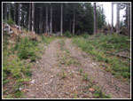
I took a few photos and was soon back on the move. Down from the tower to the first switchback where the old road turned off right and headed south down the ridge. This road is covered with spongy moss. Very easy walking. The road soon began to drop to a low point and then headed up. At the end of the road is the spot where in 2011 I had to push through closely spaced trees to get to the open forest beyond. No problem now. A path has been cut through the trees. Who ever has been doing maintenance has also cleared a foot path over to the road in the clear cut. The cut was fresh in 2011 and I climbed over many slash piles and down logs to reach the road. On the way back I followed the road to a point where I could more easily get back up to the path. Now the path continues all the way to the road in the cut. Some views out here though the clouds limited them.
At the end of the road I went right around a pile of debris and in just about 20 feet I reached the next road. This one continues, with one junction, to the real summit of McDonald Mountain. This road too has not seen wheels in some time. Lots of grass growing in it. The road follows the ridge climbing and then descending. There are several saddles in the ridge that require descents and then climbs. Each drop is a climb on the way back. There are about 500' of downhill between the tower and the real summit. Although the real summit is only some 300' higher than the tower there is 1300' of gain round trip between them. On the steepest descent the road was snow covered. Only 4 to 6 inches deep but enough to soak my light trail shoes. At the last junction I turned right uphill for the last climb. On the January 2011 trip I also faced snow on the last descent. The deepest snow that day was on the climb to the summit. Part way up the snow began. Now I was sinking in 4-7 inches with every step. Not hard but tedious. I saw what appeared to be bear prints in the snow. As big as my hand with claw marks.
Near the top I left the road to the summit and followed animal tracks up the embankment and into forest. Maybe not such a good move. There was much less snow as I'd hoped in the forest but the trees were very closely spaced. It was not much fun working my way up the last bit. The 3570' top has even less views than three years ago. Trees growing back to the west are now tall enough to block some of the view. It was sunny though. I could see the middle peak near the clear cut and also the tower on the north peak. I arrived on top just after 11:00 am. Some photos and lunch and I headed back. The snowy road was much easier with my footprints in place. Back at the clear cut I had marginally better views. Still a lot of clouds. I stopped once again at the tower site. It was warmer in the sunshine. Going down I was back on the north side and it was dramatically colder in the shade. A cold north breeze was also blowing. Gloves went back on. It was better when the road swung around to the ridge top and I was back in sun. After passing the middle blue gate I met the first folks since early morning. Farther down I was to see a few more hikers and a number of mountain bikers.
From the lower clear cut I could now see the peaks that were in the clouds in the morning. That was definitely Rattlesnake Ledges. Beyond were several cloudy peaks. At that angle that would be Mt. Si and Mt. Teneriffe. I could see all the towers along Rattlesnake Mountain and on Tiger Mountain too. This was a very unusual angle seeing the back side of those peaks. From there I went back into the forest for the last few miles. Back through the many ditches. They were much easier to cross going downhill. I made it back to the gate at 2:25 pm. Just about 6.5 hours in total. Many folks will not hike on a route composed mainly of old roads. I disagree. I had a great deal of solitude on a close in hike that totaled about 13 miles with 3600' of elevation gain. A little bit of route finding is necessary after the tower site but it's worth it to traverse the ridge all the way to the real summit. A fine day for a hike. I still need to come back again on a very clear day for all the views.
 Small Trench |
 Big Trench |
 Steep Trench |
 Salmonberry Flower |
 First Skunk Cabbage |
 More Skunk Cabbage |
 Smooth Road At Last |
 Sign Of Spring |
 Into The Lower Clear Cut |
 Clouds At Ridge Level |
 View North |
 Bit Of A View |
 Easy Walking Road |
 Quarry Junction |
 Snow Patch |
 Cloudy Tower Site View |
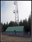 Tower & Building |
 Little Better View |
 Clouds Roll By |
 Spongy Old Road |
 Cut In Trees |
 Into The Clear Cut |
 Cloudy View |
 Another Road |
 Snow Below Real Summit |
 Big Puffy Clouds |
 Trees Growing Fast |
 Bear Prints? |
 Clearer View |
 Industrial Complex |
 Another Viewpoint |
 Paw Print Size |
 More Snow On Ascent |
 Nearing Clear Cut |
 Blue Sky & Snags |
 Wall Of White |
 Clearer At Tower Site |
 Bright Trees |
 Sunny In Low Clear Cut |
 Rattlesnake Ledges |
 Tiger Mountain |
 Last Sign Of Spring |
Trips - 2014
Home