8-16-15
I
scrambled up Mt Pugh in early October
2003. I enjoyed it so much I
planned to return regularly. Fast forward 12 years. Gwen wanted to
climb it and I was more than ready for a return visit. This trip has
considerably more elevation gain than most. The 5.5 miles to the summit
climbs 5300'. We made sure to have an early start. We met in Lynnwood
at 6:30 am and headed north. Through Arlington then on to Darrington.
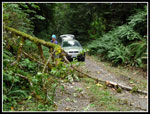
South on the Mountain Loop Highway about 12.5 miles then up the dirt
road another 1.5 miles to the trailhead. There is no parking lot as you
use a number of pull outs along the road. On the spur road to the
trailhead there was a tree down. Going wide allowed passage by driving
over the smaller end of the tree. We stopped and Gwen cut the tree. A
little detour but the road is now clear.
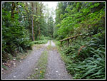
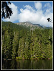
We were packed up and on the trail at 8:33 am. One car arrived early and another passed us while we were dispatching the tree. Another arrived as we started up the trail. The weather was about perfect. Cool but not cold. It was a little bit humid. It had rained a few days earlier. The trail is very well graded. This and the Sourdough Lookout trails are my picks as the easiest trails that gain a lot of elevation. No roots, few rocks, no steps, and just an even steady uphill grade. From the 1900' trailhead we made consistent progress. The guides say it is 1.5 miles to Lake Metan gaining 1300'. I think it is longer. We reached the lake in 57 minutes and we were moving well above a 1.5 mph pace.
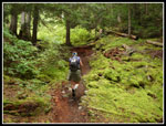
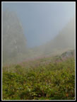
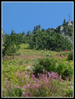
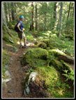
The forest is a bit scraggly down lower where it has been logged. Higher up it gets much better. The day began with clouds all over western Washington and from the lake the summit of Pugh is right above but it was lost in clouds. While the clouds did keep us cool we were hoping it would be clear on the summit. Also we have had a lot of fires this summer and smoke was a concern regarding views. We hoped the recent rain might have cleared the air, at least temporarily. A group of five guys caught up while we took a break at the lake. We headed out ahead of them.
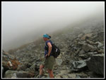
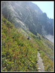
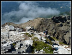
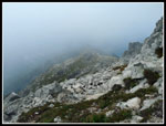
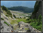
The trail continued it's smooth grade and we kept up a consistent pace. Somewhere at about 3.5 miles we reached the end of the forest. 3000' of gain brought us to the 4900' level. From here to Stujack Pass the route is through a talus field. Partly on rocks and partly on dirt trail. Gwen immediately noticed a bunch of ptarmigans. There were at least three or four of them. On my previous visit I saw one near the summit in white winter plumage. These ones were still brown. The five guys had passed us and another twosome went by too while we photographed the ptarmigans. We were near cloud level now and could not see the pass high above us.
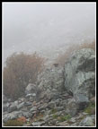
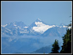
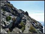
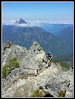
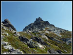
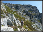
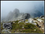
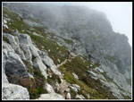
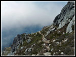
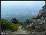
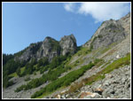
The talus field is a bit tedious but easy enough to follow. There were patches of blooming fireweed, some harebells, and even some Indian paintbrush in bloom. Lots of thimbleberries were not quite yet ripe. As we neared the pass it came into view. The clouds were quickly burning off. The pass is more a defile than a gentle pass. Not much room there. After a food and water break we headed higher. The route begins with switchbacks up heather slopes with some small trees. The last shade available. Fortunately, the temperate was still perfect. Soon we were up to the ridge top. The trail mostly follows just below the ridge on the east side. To the north we had great views of nearby Whitechuck Mountain and many North Cascade peaks. Mts. Baker and Shuksan were clearly seen. To the east it was a mix of clouds and smoke.
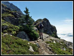
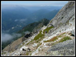
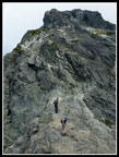
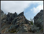
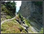
The trail along the ridge is narrow and the slope is steep. If one is not afraid of heights it is not bad. In one spot the top of the ridge was blasted off. The trail crossed right over the top. The drop on the west side is dramatic. It is only very steep on the east side. It is quite a short crossing. The route then goes along the west side for a bit before a hands on scramble back to the ridge top. This is a trail but not one many folks would be comfortable on.
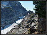
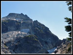
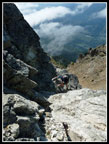
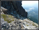
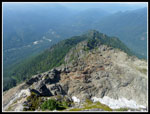
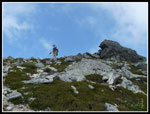
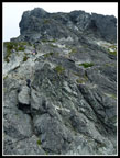
Where the ridge meets the bulk of Mt. Pugh a narrow glacier sits on the east side. We crossed right above it. It is very hollowed out and a creek can be hard flowing through it. We met a group heading down at this point. Now comes the fun part. Down to a barren saddle above the glacier then straight up. The first part was blasted out. At first a hands on rocky scramble. After a quick hundred feet up trail picks up again. There are a number of cairns to keep one on the correct path. It is a little sketchy in places. Even higher up the track meanders across open heather meadows with lots of granite. So very different from the forests now far below. Though the trail seemed to keep going on and on we did eventually reach the summit. After the scrambling below the summit is a walk up.
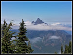
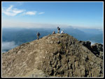
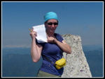
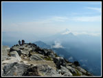
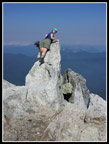
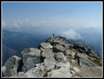
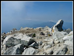
At a steady pace with a number of breaks and photo stops we arrived at 1:32 pm, for a time of 4:59. Still well over 1000' per hour of elevation gain. Though we had mostly blue sky overhead the views were less than inspiring. To the west the smoke had increased to the point that we could no longer see Three Fingers. Mt. Forgotten was very clear lower down but was not on partly visible. Most disappointing was that we could not see any of Glacier Peak. This is a great vantage point but clouds and smoke had it completely hidden. The temperature was ideal on top as it had been all day. We will just need to come back for the great views.
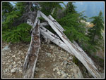
After 62 minutes on top we headed down. The exposure is much more noticeable heading down. Surprisingly, I found it to be a little easier than the ascent. We were very careful and did not have any difficulties. At the last steep drop to the saddle we had a backup. One other hiker heading down and a group heading up. No room to pass there so we just waited for the group coming up. After than it was down to the saddle then back on the narrow ridge. On my previous trip, I found the old winch on the ridge top used to raise supplies up to the summit. This time I did not see it on the way up. Going down We found the remains now lying on the ground.
Back along the ridge then down to Stujack Pass. Below the pass we met two groups still coming up. They were the last hikers we saw until almost back to the car. The talus field was a little hard on tired feet but the forest was nice and easy. Many switchbacks later we were back at the trailhead. Even with a lot of photos we sliced 40 minutes off our uphill time. Even with the limited views this was a great trip. There are not a lot of on trail trips that provide 5300' of elevation gain. It is a great workout. The different zones from forest to talus to narrow ridge to steep scramble to alpine heather and granite provides a lot of diversity. The scramble is not for the average trail hiker but well within the ability of most folks who are fine with the exposure. The views are tremendous though I'll have to base that on my photos from 2003. Gwen had a great time too. I hope I return in far less than another 12 years.
Click on thumbnails to get
larger pictures.
Trips - 2015
Home
We were packed up and on the trail at 8:33 am. One car arrived early and another passed us while we were dispatching the tree. Another arrived as we started up the trail. The weather was about perfect. Cool but not cold. It was a little bit humid. It had rained a few days earlier. The trail is very well graded. This and the Sourdough Lookout trails are my picks as the easiest trails that gain a lot of elevation. No roots, few rocks, no steps, and just an even steady uphill grade. From the 1900' trailhead we made consistent progress. The guides say it is 1.5 miles to Lake Metan gaining 1300'. I think it is longer. We reached the lake in 57 minutes and we were moving well above a 1.5 mph pace.
The forest is a bit scraggly down lower where it has been logged. Higher up it gets much better. The day began with clouds all over western Washington and from the lake the summit of Pugh is right above but it was lost in clouds. While the clouds did keep us cool we were hoping it would be clear on the summit. Also we have had a lot of fires this summer and smoke was a concern regarding views. We hoped the recent rain might have cleared the air, at least temporarily. A group of five guys caught up while we took a break at the lake. We headed out ahead of them.
The trail continued it's smooth grade and we kept up a consistent pace. Somewhere at about 3.5 miles we reached the end of the forest. 3000' of gain brought us to the 4900' level. From here to Stujack Pass the route is through a talus field. Partly on rocks and partly on dirt trail. Gwen immediately noticed a bunch of ptarmigans. There were at least three or four of them. On my previous visit I saw one near the summit in white winter plumage. These ones were still brown. The five guys had passed us and another twosome went by too while we photographed the ptarmigans. We were near cloud level now and could not see the pass high above us.
The talus field is a bit tedious but easy enough to follow. There were patches of blooming fireweed, some harebells, and even some Indian paintbrush in bloom. Lots of thimbleberries were not quite yet ripe. As we neared the pass it came into view. The clouds were quickly burning off. The pass is more a defile than a gentle pass. Not much room there. After a food and water break we headed higher. The route begins with switchbacks up heather slopes with some small trees. The last shade available. Fortunately, the temperate was still perfect. Soon we were up to the ridge top. The trail mostly follows just below the ridge on the east side. To the north we had great views of nearby Whitechuck Mountain and many North Cascade peaks. Mts. Baker and Shuksan were clearly seen. To the east it was a mix of clouds and smoke.
The trail along the ridge is narrow and the slope is steep. If one is not afraid of heights it is not bad. In one spot the top of the ridge was blasted off. The trail crossed right over the top. The drop on the west side is dramatic. It is only very steep on the east side. It is quite a short crossing. The route then goes along the west side for a bit before a hands on scramble back to the ridge top. This is a trail but not one many folks would be comfortable on.
Where the ridge meets the bulk of Mt. Pugh a narrow glacier sits on the east side. We crossed right above it. It is very hollowed out and a creek can be hard flowing through it. We met a group heading down at this point. Now comes the fun part. Down to a barren saddle above the glacier then straight up. The first part was blasted out. At first a hands on rocky scramble. After a quick hundred feet up trail picks up again. There are a number of cairns to keep one on the correct path. It is a little sketchy in places. Even higher up the track meanders across open heather meadows with lots of granite. So very different from the forests now far below. Though the trail seemed to keep going on and on we did eventually reach the summit. After the scrambling below the summit is a walk up.
At a steady pace with a number of breaks and photo stops we arrived at 1:32 pm, for a time of 4:59. Still well over 1000' per hour of elevation gain. Though we had mostly blue sky overhead the views were less than inspiring. To the west the smoke had increased to the point that we could no longer see Three Fingers. Mt. Forgotten was very clear lower down but was not on partly visible. Most disappointing was that we could not see any of Glacier Peak. This is a great vantage point but clouds and smoke had it completely hidden. The temperature was ideal on top as it had been all day. We will just need to come back for the great views.
After 62 minutes on top we headed down. The exposure is much more noticeable heading down. Surprisingly, I found it to be a little easier than the ascent. We were very careful and did not have any difficulties. At the last steep drop to the saddle we had a backup. One other hiker heading down and a group heading up. No room to pass there so we just waited for the group coming up. After than it was down to the saddle then back on the narrow ridge. On my previous trip, I found the old winch on the ridge top used to raise supplies up to the summit. This time I did not see it on the way up. Going down We found the remains now lying on the ground.
Back along the ridge then down to Stujack Pass. Below the pass we met two groups still coming up. They were the last hikers we saw until almost back to the car. The talus field was a little hard on tired feet but the forest was nice and easy. Many switchbacks later we were back at the trailhead. Even with a lot of photos we sliced 40 minutes off our uphill time. Even with the limited views this was a great trip. There are not a lot of on trail trips that provide 5300' of elevation gain. It is a great workout. The different zones from forest to talus to narrow ridge to steep scramble to alpine heather and granite provides a lot of diversity. The scramble is not for the average trail hiker but well within the ability of most folks who are fine with the exposure. The views are tremendous though I'll have to base that on my photos from 2003. Gwen had a great time too. I hope I return in far less than another 12 years.
 Log Over Road |
 Road Now Clear |
 Big False Solomon's Seal |
 Falling Trees |
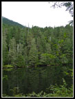 Lake Metan |
 Mossy Forest |
 Out Of The Forest |
 Ptarmigan |
 Pass In Clouds |
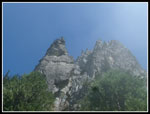 Spires |
 Clouds & Mt. Forgotten |
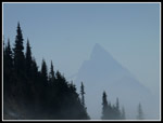 Cloudy Sloan Peak |
 Fireweed |
 Nearing Stujack Pass |
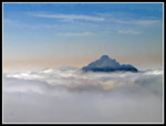
 Eldorado Peak? |
 Whitechuck In Clouds |
 Heading Up To Ridge |
 Nearing Glacier |
 Mt. Pugh |
 Trail Above Cliffs |
 Gwen On Ridge Top |
 Bump Above Saddle |
 Steep Blasted Route |
 Hands On Scrambling |
 Traversing |
 Above Sketchy Spot |
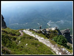 Photo Time |
 Lower Ridge In Sight |
 Summit In Sight |
 Final Traverse |
 Gwen With Register |
 Group Near Summit |
 Gwen On Summit Point |
 Summit Ridge |
 Lookout Site |
 Heading Down |
 Traversing In Clouds |
 Around The Corner |
 Trail Below |
 Blue Sky Above |
 Sketchy Descent |
 Glacier Below |
 Down Steep Spot |
 Heading Up |
 Lake Is Way Below |
 Back On Ridge |
 Old Winch |
 Back To Stujack Pass |
 View Down From Pass |
 Stujack Is Above |
 Green Mossy Forest |
 Pugh From Lake |
Trips - 2015
Home