Days 2 & 3
Day
2
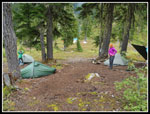
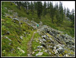
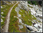
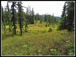
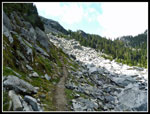
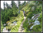
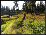
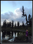
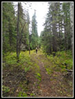
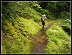
We did sleep in until 8:30 am on Sunday. Much to our surprise there was no rain overnight. Though the cloud level was about 100' above us, it was windless, and it was misty there was almost no condensation. We had a leisurely breakfast and packed up light day packs for the day's explorations. Though Kim had been to Fortune Ponds three times and I had been there once, none of us, including Janet, had been over the pass to Pear Lake and the PCT. We were on the trail at the crack of 10:20 am. Not quite an alpine start. The old PCT up to Frozen Finger Pass and down to Pear Lake was not only in good shape, it had many signs of recent work. Brushing has made it a very dry trail on a wet day. We had a dry day. I had been up a short way on the trail when scrambling to the upper pond in 2013. Very soon we were on trail new to all three of us. As with most of the PCT, even this now longer used section, it is smooth and gently graded. We took about a mile to climb 550' to the pass.
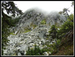
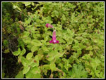
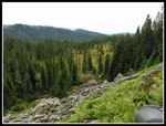
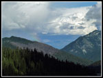
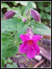
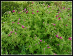
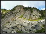
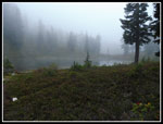
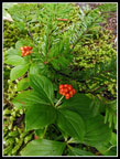
Along the way there is a lot to see. We did not have much of a view out as the low clouds made for a white panorama. Closer up we had steep granite walls and house sized rocks strewn below. Lots and lots of almost fluorescent green moss. Of course, even more big ripe huckleberries. We took our time heading up stopping for lots of photos. Unfortunately, Kim's dslr lens fogged up for the first time and made photos nearly impossible for her. A big disappointment for all of us. It did clear up after we returned to camp. There were a couple steep creeks in gullys that were very photogenic. one was lined on both sides with a wide swath of Lewis monkeyflower. Only a few were in bloom but many more were almost there. That would be a riot of color with a little better timing.
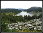
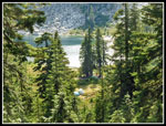
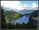
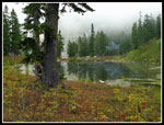
From a small meadow the last 100 or so feet is gained quickly with a series of short switchbacks. The pass is a narrow cut in the ridge. From the top Pear Lake is right below. The big pear shaped lake is quite a sight. Low clouds blocked out all views but the lake. The route down is just a few long switchbacking traverses. The route crosses several big boulder fields where the trail was blasted out. The sound of pikas was nearly constant. I saw one up close near camp the night before. Janet has a close up visit below Frozen Finger Pass. Later we heard one lone marmot whistle. We could see tents down near the lake. The trail drops down to the north side of the lake. We soon saw only the second party in a day and a half of hiking. There were more folks at Pear Lake.
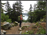
We met a group in a big well stocked site. Three generations of family. The oldest was age 80. The youngest looked to be about 7. They brought in gear via a pack train. They were having a very good time, rain or no rain. We took a break along the lakeshore. For the first time all day it was windy. A cold wind. On went the jackets. Kim and I planned to hike to the PCT then head south .70 miles to the junction with the Top Lake Trail. A short third of a mile more goes to the Lake. Janet is judicious after two knee replacements and chose to stay at the lake while we dropped down to Pear Lake. She still managed over 4000' of gain for the weekend. We planned to meet at the PCT junction in 1.25 hours. We passed several big camps at the other end of the lake and quickly reached the PCT. The route is all downhill to the junction. We passed several Mexico to Canada through hikers on our short trip down and backup on the PCT.
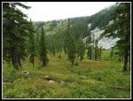
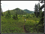
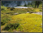
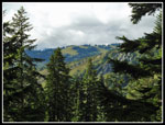
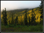
The descent was mostly in forest put lower down we came out into the open. And it is very open. Some huge meadows just above Wenatchee Pass. The leaves were just beginning to turn color. In a few weeks this will be a real vision of colors. From the junction it is nearly flat over to Top Lake. We arrived as the sky was clearing. We even saw shadows for a change. Top Lake is much smaller than Pear but is pretty enough. Lots of berry bushes around the lake. Sweet fruit now and some great colors soon. We saw two filled campsites. There may well be more farther around the lake. Our stay was short and we headed back to the PCT. The 300' climb went quickly and Janet was waiting at the Pear Lake junction.
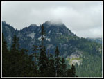
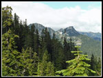
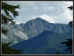
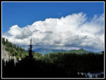
We had planned to hike a ways north along the PCT. The route starts in forest and has some modest ups and downs. We started to get some clear views out to the north and east. Though we knew many of the peaks and ridges in sight we had a tough time figuring out what was what. Nothing looked like it should. The one peak we all agreed on was Kodak Peak. Poet's ridge runs right into Kodak Peak at the PCT but nothing looked like it. Well, we enjoyed the views anyway. We hiked about a mile or so to where the trail begins a steeper climb up to and over the crest to the west side. It was steep enough and late enough in the day that we chose to turn around there. We hiked back to Pear Lake and took another break along the lakeshore. We were not in a big hurry to get back to camp so we enjoyed an extended visit.
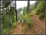
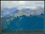
At 3:30 pm we headed back. The wind at the lake did not last long as we quickly were out of it. On the way back to the pass we met several groups and stopped to talk. With camp just a mile plus away we were in no hurry. We met the three generations of the big party crossing the big boulder field. The oldest gentleman has been hiking these mountains for many decades. Higher up we met a couple. The guy had scrambled up Fortune Mountain, above Fortune Ponds, some twenty years earlier. He and his companion found that time can mess up ones recall of a route. I have that problem occasionally too. They did not summit but had a good time trying. Higher up Kim noticed a rainbow on the shoulder of Shoofly Mountain. Farther north we saw rain. It never reached us. We crossed over Frozen Finger Pass and dropped down the smoothly graded trail. I stopped to photograph some monkeyflower along the one creek. Now there was a wind blowing down the creek Many blurry shots later I had a few keepers and hurried to catch up. The ridge across the valley was now out of the clouds. We could see much of the old abandoned PCT along the green brushy slopes. We arrived at camp at 5:35 pm.
All that was left was dinner, some more exploring around the pond and late evening photos. We were all in our tents by 8:10 pm. Having a base camp and then day hiking with light packs made for an easy and very enjoyable day. We saw a couple new lakes and hiked a new section of the PCT. The meadows and ripe berries were outstanding. The clouds even thinned out for a few hours. That did not last by bed time the low clouds had dropped back over the pond. On Monday all we had to do was hike out 6.5 miles with nearly all of it downhill. We hoped to get back early enough to miss the worst of the standard holiday traffic backup on Highway 2.
Day 3
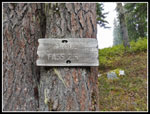
We were up and out of our tents by 7:00 am. We hoped to have breakfast and pack up by 8:30 am. It always takes longer than it seems it should. We did pretty well as we hoisted our packs and headed back at 8:20 am. A short uphill out of the basin through meadows of berry bushes and then into the forest. We made pretty good time heading down to Fortune Pass. A sign at the pond said 2.5 miles to the pass. We hiked it in 56 minutes. Not many photos or stops of any kind. At the pass we dropped packs and started crawling around the down trees. Kim had seen the "Fort Ass" sign three times and was pretty sure where it was. It was on a big wide tree to the left of the trail when ascending. Looking in that area and checking for a big enough tree left us pretty sure we found the tree. It fell down with the sign laying on the ground. The sign is most likely buried in dirt under a ton or so of tree. Short of digging a pit at the correct height on the tree it will likely never be seen again. For us history buffs that is an unfortunate loss. We spent about 20 minutes at the pass and headed on down.
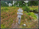
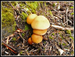
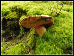
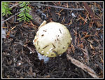
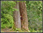
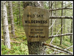
We had been careful at the spot where the other group reported a yellowjacket sting but had no problem. We did not see nearly as many yellowjackets going down as when coming up. The earlier start and cooler temperatures may have been the reason. One more stop at the second crossing of Meadow Creek. It was now nearly 10:00 am. Time for a quick lunch. The rest of the way down we hiked at a consistent clip but took many photo stops. Big trees, shelf fungus, mushrooms, tons of moss. There was a lot to see. When we reached the series of switchbacks down to the trailhead the rocky trail took a toll on tired legs. On the way up we saw the Henry M. Jackson Wilderness sign but we all missed the Wild Sky Wilderness sign. Going down it was on the other side of the tree but we saw it. Two different wildernesses in one hike. We saw several groups day hiking up as we descended. At 12:45 pm we reached the trailhead.
The drive home was fine until we reached the passing zone east of Gold Bar. Traffic came to a halt. It was stop and go from there to the last light in Sultan. Then we were fine the rest of the way home. Even Monroe was not too bad. We spent a few hours in traffic but it was not nearly as bad as later on many holiday weekends. This was a very fun trip. We saw only one group the first day. More the second but it was never crowded. We saw only three or four groups the last day. Considering that we were not far off Highway 2 the solitude was amazing. It was fun to return to Fortune Ponds and also to hike new trails too. The berries were an unexpected treat. Filling my oatmeal dish in less than a minute was a treat. Yes, it rained much of the first day but it did not mar the holiday weekend. My first backpacking trip in over a year was a rousing success. Thanks to Kim and Janet for the company.
We did sleep in until 8:30 am on Sunday. Much to our surprise there was no rain overnight. Though the cloud level was about 100' above us, it was windless, and it was misty there was almost no condensation. We had a leisurely breakfast and packed up light day packs for the day's explorations. Though Kim had been to Fortune Ponds three times and I had been there once, none of us, including Janet, had been over the pass to Pear Lake and the PCT. We were on the trail at the crack of 10:20 am. Not quite an alpine start. The old PCT up to Frozen Finger Pass and down to Pear Lake was not only in good shape, it had many signs of recent work. Brushing has made it a very dry trail on a wet day. We had a dry day. I had been up a short way on the trail when scrambling to the upper pond in 2013. Very soon we were on trail new to all three of us. As with most of the PCT, even this now longer used section, it is smooth and gently graded. We took about a mile to climb 550' to the pass.
Along the way there is a lot to see. We did not have much of a view out as the low clouds made for a white panorama. Closer up we had steep granite walls and house sized rocks strewn below. Lots and lots of almost fluorescent green moss. Of course, even more big ripe huckleberries. We took our time heading up stopping for lots of photos. Unfortunately, Kim's dslr lens fogged up for the first time and made photos nearly impossible for her. A big disappointment for all of us. It did clear up after we returned to camp. There were a couple steep creeks in gullys that were very photogenic. one was lined on both sides with a wide swath of Lewis monkeyflower. Only a few were in bloom but many more were almost there. That would be a riot of color with a little better timing.
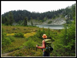
From a small meadow the last 100 or so feet is gained quickly with a series of short switchbacks. The pass is a narrow cut in the ridge. From the top Pear Lake is right below. The big pear shaped lake is quite a sight. Low clouds blocked out all views but the lake. The route down is just a few long switchbacking traverses. The route crosses several big boulder fields where the trail was blasted out. The sound of pikas was nearly constant. I saw one up close near camp the night before. Janet has a close up visit below Frozen Finger Pass. Later we heard one lone marmot whistle. We could see tents down near the lake. The trail drops down to the north side of the lake. We soon saw only the second party in a day and a half of hiking. There were more folks at Pear Lake.
We met a group in a big well stocked site. Three generations of family. The oldest was age 80. The youngest looked to be about 7. They brought in gear via a pack train. They were having a very good time, rain or no rain. We took a break along the lakeshore. For the first time all day it was windy. A cold wind. On went the jackets. Kim and I planned to hike to the PCT then head south .70 miles to the junction with the Top Lake Trail. A short third of a mile more goes to the Lake. Janet is judicious after two knee replacements and chose to stay at the lake while we dropped down to Pear Lake. She still managed over 4000' of gain for the weekend. We planned to meet at the PCT junction in 1.25 hours. We passed several big camps at the other end of the lake and quickly reached the PCT. The route is all downhill to the junction. We passed several Mexico to Canada through hikers on our short trip down and backup on the PCT.
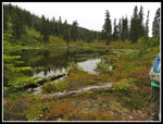
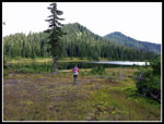
The descent was mostly in forest put lower down we came out into the open. And it is very open. Some huge meadows just above Wenatchee Pass. The leaves were just beginning to turn color. In a few weeks this will be a real vision of colors. From the junction it is nearly flat over to Top Lake. We arrived as the sky was clearing. We even saw shadows for a change. Top Lake is much smaller than Pear but is pretty enough. Lots of berry bushes around the lake. Sweet fruit now and some great colors soon. We saw two filled campsites. There may well be more farther around the lake. Our stay was short and we headed back to the PCT. The 300' climb went quickly and Janet was waiting at the Pear Lake junction.
We had planned to hike a ways north along the PCT. The route starts in forest and has some modest ups and downs. We started to get some clear views out to the north and east. Though we knew many of the peaks and ridges in sight we had a tough time figuring out what was what. Nothing looked like it should. The one peak we all agreed on was Kodak Peak. Poet's ridge runs right into Kodak Peak at the PCT but nothing looked like it. Well, we enjoyed the views anyway. We hiked about a mile or so to where the trail begins a steeper climb up to and over the crest to the west side. It was steep enough and late enough in the day that we chose to turn around there. We hiked back to Pear Lake and took another break along the lakeshore. We were not in a big hurry to get back to camp so we enjoyed an extended visit.
At 3:30 pm we headed back. The wind at the lake did not last long as we quickly were out of it. On the way back to the pass we met several groups and stopped to talk. With camp just a mile plus away we were in no hurry. We met the three generations of the big party crossing the big boulder field. The oldest gentleman has been hiking these mountains for many decades. Higher up we met a couple. The guy had scrambled up Fortune Mountain, above Fortune Ponds, some twenty years earlier. He and his companion found that time can mess up ones recall of a route. I have that problem occasionally too. They did not summit but had a good time trying. Higher up Kim noticed a rainbow on the shoulder of Shoofly Mountain. Farther north we saw rain. It never reached us. We crossed over Frozen Finger Pass and dropped down the smoothly graded trail. I stopped to photograph some monkeyflower along the one creek. Now there was a wind blowing down the creek Many blurry shots later I had a few keepers and hurried to catch up. The ridge across the valley was now out of the clouds. We could see much of the old abandoned PCT along the green brushy slopes. We arrived at camp at 5:35 pm.
All that was left was dinner, some more exploring around the pond and late evening photos. We were all in our tents by 8:10 pm. Having a base camp and then day hiking with light packs made for an easy and very enjoyable day. We saw a couple new lakes and hiked a new section of the PCT. The meadows and ripe berries were outstanding. The clouds even thinned out for a few hours. That did not last by bed time the low clouds had dropped back over the pond. On Monday all we had to do was hike out 6.5 miles with nearly all of it downhill. We hoped to get back early enough to miss the worst of the standard holiday traffic backup on Highway 2.
Day 3
We were up and out of our tents by 7:00 am. We hoped to have breakfast and pack up by 8:30 am. It always takes longer than it seems it should. We did pretty well as we hoisted our packs and headed back at 8:20 am. A short uphill out of the basin through meadows of berry bushes and then into the forest. We made pretty good time heading down to Fortune Pass. A sign at the pond said 2.5 miles to the pass. We hiked it in 56 minutes. Not many photos or stops of any kind. At the pass we dropped packs and started crawling around the down trees. Kim had seen the "Fort Ass" sign three times and was pretty sure where it was. It was on a big wide tree to the left of the trail when ascending. Looking in that area and checking for a big enough tree left us pretty sure we found the tree. It fell down with the sign laying on the ground. The sign is most likely buried in dirt under a ton or so of tree. Short of digging a pit at the correct height on the tree it will likely never be seen again. For us history buffs that is an unfortunate loss. We spent about 20 minutes at the pass and headed on down.
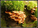
We had been careful at the spot where the other group reported a yellowjacket sting but had no problem. We did not see nearly as many yellowjackets going down as when coming up. The earlier start and cooler temperatures may have been the reason. One more stop at the second crossing of Meadow Creek. It was now nearly 10:00 am. Time for a quick lunch. The rest of the way down we hiked at a consistent clip but took many photo stops. Big trees, shelf fungus, mushrooms, tons of moss. There was a lot to see. When we reached the series of switchbacks down to the trailhead the rocky trail took a toll on tired legs. On the way up we saw the Henry M. Jackson Wilderness sign but we all missed the Wild Sky Wilderness sign. Going down it was on the other side of the tree but we saw it. Two different wildernesses in one hike. We saw several groups day hiking up as we descended. At 12:45 pm we reached the trailhead.
The drive home was fine until we reached the passing zone east of Gold Bar. Traffic came to a halt. It was stop and go from there to the last light in Sultan. Then we were fine the rest of the way home. Even Monroe was not too bad. We spent a few hours in traffic but it was not nearly as bad as later on many holiday weekends. This was a very fun trip. We saw only one group the first day. More the second but it was never crowded. We saw only three or four groups the last day. Considering that we were not far off Highway 2 the solitude was amazing. It was fun to return to Fortune Ponds and also to hike new trails too. The berries were an unexpected treat. Filling my oatmeal dish in less than a minute was a treat. Yes, it rained much of the first day but it did not mar the holiday weekend. My first backpacking trip in over a year was a rousing success. Thanks to Kim and Janet for the company.
 Morning In Camp |
 Abandoned Trail |
 Morning At The Pond |
 Heading Out |
 Ascending Old PCT |
 Mushroom Condos |
 False Hellebore |
 Switchback |
 Cloudy Cliffs |
 Monkey Flowers |
 Basin |
 Frozen Finger Pass |
 Pear Lake Below |
 Hand Built Trail |
 Arriving At Pear Lake |
 Cloudy Peak |
 Colorful Mushroom |
 Meadows Below |
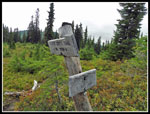 Trail Junction |
 Top Lake |
 Leaving Top Lake |
 More Meadows |
 Amanita Mushroom |
 View North On PCT |
 Kodak Peak |
 A Bunch Of Mushrooms |
 Turn Around Point |
 Heading Back On PCT |
 Labyrinth Mountain |
 Tents At Pear Lake |
 Bright Moss At Lake |
 Big White Cloud |
 Nearing Pass |
 Shoofly Mountain |
 West Cady Ridge |
 Lewis Monkey Flower |
 More Monkey Flowers |
 Cloudless Cliffs |
 Color At Camp |
 Dinner Time |
 Near Sunset At Pond |
 Sunset Snag |
 Almost Like Larch |
 Evening At Camp |
 Misty Monday Morning |
 Fortune Mountain |
 Mileage Sign |
 Leaving The Pond |
 Parnassus |
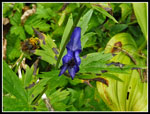 Monkshood |
 Meadow Creek Crossing |
 Lonely Trail |
 Bunchberries |
 Mossy Trail |
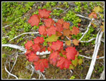 Turning Color |
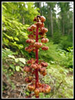 Pinedrops |
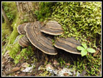 More Shelf Fungi |
 Peek-A-Boo |
 Wild Sky Wilderness |
 Trailhead Map |
<< Photo Page
Fortune Ponds & Beyond Report
Trips - 2016
Home