12-02-17
I
had conversed with Doug McKeever online several years ago. Plans for a
hike never worked out. Now he contacted me and Kim with an idea for a
hike. I have been exploring the trails on Chuckanut Mountain and
Blanchard Hill south of Bellingham the past 7 or 8 years. Doug had been
up Anderson Mountain just to the east across I-5. We were interested.
We were all free for Saturday though the forecast was for rain with
snow above 2500'. The summit is at 3364'. The trailhead is at about
500'. Okay, so we would get rained on for the first 2000' of gain then
snowed on up above. I was on Tiger Mountain on Wednesday and there was
zero snow at 2750'. I threw in some gaiters in case we had a few inches
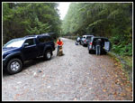
up top. We met at the Alger Park & Ride right off exit 240 on
I-5 at 8:00 am. It was only 65 miles from Kim's place in Shoreline,
just north of Seattle. Karl and his friend David also came along. We
continued on the road through "downtown" Alger, across Old 99 and a
mile or so the the signed right turn for the Alger CCC Road. A short
way on the right is the gated road. We managed to fit three cars
without blocking the gate.
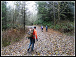
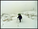
At was 8:27 when we headed up the road/trail. The Pacific Northwest Trail (PNT) goes over Anderson Mountain. One can go to the summit from the west side or the east side on Highway 9. There is also a road up the south side to near the summit. It is only open from September to year end. Right now, it is washed out. No driving up for now. The PNT is a work in progress. In this area part of it is on road and part on trail. Our route had some of each. There are not a lot of reports on this route. The trail portions seem to be fairly new. There has been logging along the current route fairly recently. The peak does have a significant elevation from bottom to top, especially for such a low summit. It is the 50th most prominent peak in Washington state. For that reason, peakbaggers have been going for the summit by whatever route they can. Hikers don't seem to be discovering this road and trail route with clear cuts along the way. Well, I have never let a few roads stop me from a hike.
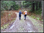
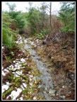
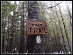
At about one mile up the road switches back to the right and a road goes off to the left. We went left and quickly reached the trail heading uphill right on our right. There is a tree a short way up seen from the main road with white rectangles. That is the sign for the PNT. We had to jump fast flowing water in a ditch to get on the trail. The trail segments of the route are very nice. A relatively gentle grade on well built tread. Even on a wet day after lots of recent wet days it was not very muddy. The low usage helps too. We had a switchback or two with a long traverse before a final switchback to the left and the trail reached the end of an old logging road. We followed the road to a "T" junction and turned right. More big white rectangles on trees to signify the PNT. Within a few minutes the we turned left on another road. We followed this a few more minutes until the trial heads off to the right. There is a very big old stump at this 1630' junction.
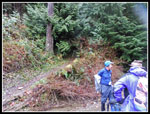
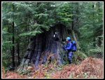
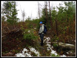
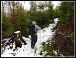
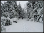
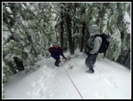
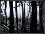
We soon entered a dark forest. There are a few boardwalks that are very slick. We managed to pass without any falls. The trail hits one old road and goes right across back onto trail. We left forest into a clear cut. Trees were still fairly small though brush has grown back. We came to an unsigned junction. There was a little bit of fresh snow here. Doug had found through trail and error that the trail to the right shortly reaches a road. We needed to go left. Coming back, straight ahead goes to the road. You need to turn right and up a small rise to be on the correct trail. The trade though the clear cut was still pretty gentle. Parts of the trail were a creek along here. I had my heavier leather boots and keep mostly dry feet. We climbed back up to forest on the edge of the clear cut. On a clear day there are views of Lake Whatcom I'm told. No views on this day.
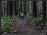
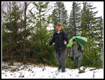
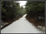
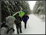
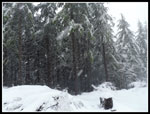
We stopped at about 11:05 for a food and water break. So far it had drizzled but not rained hard. I was fairly dry with an umbrella. The trail was not brushy at all. No concerns about soaking wet brush. Someone has done a good job of brushing the clear cut sections of trail. We were soon back on our way. The trail reached a flat area we had a little downhill too as we reached the main road which leads almost to the summit. Coming out of the forest the road was completely covered with a thin coating of fresh snow. It was very scenic. We had covered 4 miles and were at 2600'. I have not seen any mileage records for our route. Doug had estimated it at about 5 or so miles each way. With 765' to go on a road it was going to be more than one more mile. It was only 11:30 pm so we had five full hours of daylight left. How long could it take to hike up a smooth road?
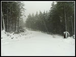
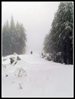
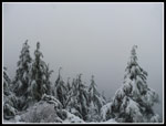
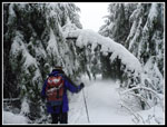
There were no markers I saw but a map would tell you to turn left on the road. It soon switches back and begins one very long traverse. As we hiked along the snow began to get deeper. At first we walked side by side. That gave way to single file as the leader was sinking 3-6" deep in fresh snow. Not hard but tiring and not very fast. With no recent snow seen at these elevations and a forecast for an inch or so this day we did not bring snowshoes. At about 4.5 miles Kim's knee was hurting. She chose to head down. The long traverse kept on going. When we reached a clear cut the snow became deeper. Never deep enough to require snowshoes but it became more and more work. Snow started lightly when we started up the road but it grew harder and never stopped. It was very beautiful. Bare ground a few days earlier and full on winter now.
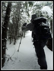
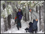
We finally reached the junction where the road from the south comes in. Now we were heading north towards the summit. Several of us stopped to but on gaiters and adjust clothing. Our steady pace was still pretty slow. We had the road junction at 12:30 pm. Four hours of daylight used and four hours left. We reached the end of the road and continued on another closed road. With the snow it was hard to tell the difference. A few old roads went off but we continued straight ahead. Finally, Doug pointed out the "tunnel" where branches were cut out providing an entry to the forest. Just ahead is a big pond I had seen in every trip report. It was white with snow. The last climb was only about 75'. Gentle at first then much steeper for the last bit. The route went up the south nose of the ridge. I had seen photos of rock with lots of moss on it. The snow was not consolidated but did provide reasonable steps up to the top. We arrived at the forested summit at 1:19 pm. One big window for views but all we saw were clouds.
A little food and water and we were ready to head down. Doug brought along a hand line and we put it to use. It as only about 40' or so to reach gentler terrain but a slip on the loose snow near the top could be problematic. It took longer but was safer getting off the summit. We regrouped on the road and headed down. It was now. It was now 1:40 pm. We had 3:15 of daylight left. It was a little easier slogging down in our footprints but not a lot faster. That road seemed endless. I was glad when we reached the spot where we exited the road for the PNT trail. It was 3:06. Two miles of road walking took 1:26. Four miles to go and 1:30 of daylight. On the positive side once off snow the trail and roads are easy headlamp hiking.
We made good time on the trail. Wet took one break where the wrong trail goes out to a road. I was surprised that we still had a little light when we reached that last 1.2 miles of road. It was almost dark when we reached the cars at 4:45 pm. I first checked Kim's car and found... no Kim. Uh oh. I had put my phone in airplane mode to save battery power. Kim took a wrong turn and left me a message. I found it and called her immediately. She had found the right route and was coming down. When she took out her headlight it worked then it fell and hit the ground and stopped working. She was able to tell us exactly where she was. Doug and I needed to head back up to deliver light. After 12 miles with 2900' of gain, partly on snow, we were not feeling great but need to go back up. A fog settled in and we could barely see the sides of the road. I walked off it a few times. We went up to the start of the trail then on trail to where it turned to road. Kim was waiting. The walk on down went fine.
This was a fun trip. A "little" mountain not far from salt water provided a long 12 round trip route with 2900' of gain. As it turned out Doug and I upped that to 16 miles with 4000' of gain. The snowy road was deep enough to add a lot of effort and slow us down significantly. The summit scramble was short but fun. There are some great views along the way on a sunny day. I'll have to come back to see those. I'll add this to my close to Puget Sound winter hiking trips. It will be a long time before this hike becomes crowded. It was neat to meet Doug, Karl, and David. We all had a good time.
Click on thumbnails to get
larger pictures.
Trips - 2017
Home
At was 8:27 when we headed up the road/trail. The Pacific Northwest Trail (PNT) goes over Anderson Mountain. One can go to the summit from the west side or the east side on Highway 9. There is also a road up the south side to near the summit. It is only open from September to year end. Right now, it is washed out. No driving up for now. The PNT is a work in progress. In this area part of it is on road and part on trail. Our route had some of each. There are not a lot of reports on this route. The trail portions seem to be fairly new. There has been logging along the current route fairly recently. The peak does have a significant elevation from bottom to top, especially for such a low summit. It is the 50th most prominent peak in Washington state. For that reason, peakbaggers have been going for the summit by whatever route they can. Hikers don't seem to be discovering this road and trail route with clear cuts along the way. Well, I have never let a few roads stop me from a hike.
At about one mile up the road switches back to the right and a road goes off to the left. We went left and quickly reached the trail heading uphill right on our right. There is a tree a short way up seen from the main road with white rectangles. That is the sign for the PNT. We had to jump fast flowing water in a ditch to get on the trail. The trail segments of the route are very nice. A relatively gentle grade on well built tread. Even on a wet day after lots of recent wet days it was not very muddy. The low usage helps too. We had a switchback or two with a long traverse before a final switchback to the left and the trail reached the end of an old logging road. We followed the road to a "T" junction and turned right. More big white rectangles on trees to signify the PNT. Within a few minutes the we turned left on another road. We followed this a few more minutes until the trial heads off to the right. There is a very big old stump at this 1630' junction.
We soon entered a dark forest. There are a few boardwalks that are very slick. We managed to pass without any falls. The trail hits one old road and goes right across back onto trail. We left forest into a clear cut. Trees were still fairly small though brush has grown back. We came to an unsigned junction. There was a little bit of fresh snow here. Doug had found through trail and error that the trail to the right shortly reaches a road. We needed to go left. Coming back, straight ahead goes to the road. You need to turn right and up a small rise to be on the correct trail. The trade though the clear cut was still pretty gentle. Parts of the trail were a creek along here. I had my heavier leather boots and keep mostly dry feet. We climbed back up to forest on the edge of the clear cut. On a clear day there are views of Lake Whatcom I'm told. No views on this day.
We stopped at about 11:05 for a food and water break. So far it had drizzled but not rained hard. I was fairly dry with an umbrella. The trail was not brushy at all. No concerns about soaking wet brush. Someone has done a good job of brushing the clear cut sections of trail. We were soon back on our way. The trail reached a flat area we had a little downhill too as we reached the main road which leads almost to the summit. Coming out of the forest the road was completely covered with a thin coating of fresh snow. It was very scenic. We had covered 4 miles and were at 2600'. I have not seen any mileage records for our route. Doug had estimated it at about 5 or so miles each way. With 765' to go on a road it was going to be more than one more mile. It was only 11:30 pm so we had five full hours of daylight left. How long could it take to hike up a smooth road?
There were no markers I saw but a map would tell you to turn left on the road. It soon switches back and begins one very long traverse. As we hiked along the snow began to get deeper. At first we walked side by side. That gave way to single file as the leader was sinking 3-6" deep in fresh snow. Not hard but tiring and not very fast. With no recent snow seen at these elevations and a forecast for an inch or so this day we did not bring snowshoes. At about 4.5 miles Kim's knee was hurting. She chose to head down. The long traverse kept on going. When we reached a clear cut the snow became deeper. Never deep enough to require snowshoes but it became more and more work. Snow started lightly when we started up the road but it grew harder and never stopped. It was very beautiful. Bare ground a few days earlier and full on winter now.
We finally reached the junction where the road from the south comes in. Now we were heading north towards the summit. Several of us stopped to but on gaiters and adjust clothing. Our steady pace was still pretty slow. We had the road junction at 12:30 pm. Four hours of daylight used and four hours left. We reached the end of the road and continued on another closed road. With the snow it was hard to tell the difference. A few old roads went off but we continued straight ahead. Finally, Doug pointed out the "tunnel" where branches were cut out providing an entry to the forest. Just ahead is a big pond I had seen in every trip report. It was white with snow. The last climb was only about 75'. Gentle at first then much steeper for the last bit. The route went up the south nose of the ridge. I had seen photos of rock with lots of moss on it. The snow was not consolidated but did provide reasonable steps up to the top. We arrived at the forested summit at 1:19 pm. One big window for views but all we saw were clouds.
A little food and water and we were ready to head down. Doug brought along a hand line and we put it to use. It as only about 40' or so to reach gentler terrain but a slip on the loose snow near the top could be problematic. It took longer but was safer getting off the summit. We regrouped on the road and headed down. It was now. It was now 1:40 pm. We had 3:15 of daylight left. It was a little easier slogging down in our footprints but not a lot faster. That road seemed endless. I was glad when we reached the spot where we exited the road for the PNT trail. It was 3:06. Two miles of road walking took 1:26. Four miles to go and 1:30 of daylight. On the positive side once off snow the trail and roads are easy headlamp hiking.
We made good time on the trail. Wet took one break where the wrong trail goes out to a road. I was surprised that we still had a little light when we reached that last 1.2 miles of road. It was almost dark when we reached the cars at 4:45 pm. I first checked Kim's car and found... no Kim. Uh oh. I had put my phone in airplane mode to save battery power. Kim took a wrong turn and left me a message. I found it and called her immediately. She had found the right route and was coming down. When she took out her headlight it worked then it fell and hit the ground and stopped working. She was able to tell us exactly where she was. Doug and I needed to head back up to deliver light. After 12 miles with 2900' of gain, partly on snow, we were not feeling great but need to go back up. A fog settled in and we could barely see the sides of the road. I walked off it a few times. We went up to the start of the trail then on trail to where it turned to road. Kim was waiting. The walk on down went fine.
This was a fun trip. A "little" mountain not far from salt water provided a long 12 round trip route with 2900' of gain. As it turned out Doug and I upped that to 16 miles with 4000' of gain. The snowy road was deep enough to add a lot of effort and slow us down significantly. The summit scramble was short but fun. There are some great views along the way on a sunny day. I'll have to come back to see those. I'll add this to my close to Puget Sound winter hiking trips. It will be a long time before this hike becomes crowded. It was neat to meet Doug, Karl, and David. We all had a good time.
 Small Parking Area |
 Starting Up Road |
 Start Of Trail |
 Small Creek |
 Back On Road |
 Big Stump |
 Back In Dark Forest |
 First Snow |
 Trail Is A Creek |
 On Snow Now |
 Kim & Karl |
 Old PNT Sign |
 New Trail Sign |
 Onto Snowy Road |
 Break Time |
 Snow Is Getting Deeper |
 Out In The Open |
 Ridge Top Road |
 Older Road |
 Final Slope |
 Summit View? |
 Guys On The Summit |
 Heading Down Heading Down |
 Back On Road |
 Snowing Hard |
 Not Great View Day |
 Dark At The Trailhead |
Trips - 2017
Home