6-16-18
Several
months ago I was looking
for hikes in the Bellingham area and found a Whatcom County Parks page
for the Canyon Lake Community Forest. A lake, and old growth forest,
and a ridge top viewpoint. It sounded great. The bad news is that the
road in was washed out in 2009. Nine years later it is still washed
out. The road can be walked or biked but it is about 6 miles each way
with around 1700' of gain. That's just to get to the trailhead. It
peaked my interest. I called the Regional Parks Supervisor and received
more info. One of the bridges is out. It can be a dicey crossing with
high spring creek levels. Also, the ridge top is at 4400' meaning snow
until late spring or early summer. I put the idea on the back burner
until now. With a chance of thundershowers in the mountains I was
looking for something in the foothills. I-90 was not appealing again so
I brought back the idea of a visit to the Canyon Lake Community Forest.
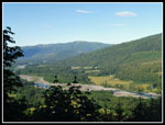
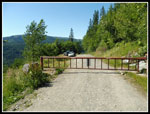
I had pieced together another road option though it had very limited parking. One or two spots by the gate. It did cut the distance to the lake down to four miles with only about 1150' of elevation gain. Time to give it a try. It is a 105 mile drive from North Seattle and took almost two hours. Up Highway 9 to Highway 542 then across the NF Nooksack River and onto logging roads. My medium low clearance sedan had no trouble as with active logging the roads were in excellent shape. I'd hate to meet a logging truck on the road as it gains elevation very steeply to the gate. I arrived at the gate at 7:55 am. It would be a long day. I needed an early start. Yep, room for two cars to park off the edge of the road just before the gate. It would be challenging to fit a third. With two cars there, turning around would also be very challenging. The drop off the side of the road is nearly vertical. Maybe a 50 point turn could be done. Two feet forward, crank the wheel, then two feet back. Parked off the road, I had no problem turning around at the end of the day. Beware of trying this with the minimal parking situation.
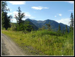
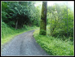
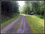
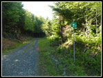
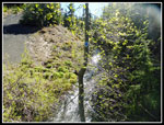
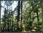
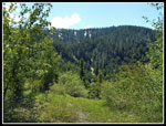
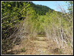
My 8:05 am I was packed up and on my way. The gate is at 1200'. The trailhead at Canyon Lake is at 2350'. Most of the elevation gain is in the first two of four total miles of road. I chose to walk rather than bring a bike along. I had no idea about the road conditions. The road is smooth and hikes very fast. At the half mile mark I met the Canyon Lake Road that is washed out. There are several road junctions. Most have a green and white metal sign with an arrow. It points to the trailhead. If a road goes off steeply uphill or downhill do not take it. One uphill road is for active logging and is more heavily used but is not the correct route. Early on there are views down to the Nooksack River and out to forested peaks. Much of the road section is forested with no views. There were a lot of wildflowers along the road. Especially foxglove, buttercups, and daisies.
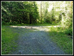
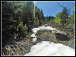
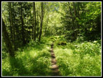
I made good time on the road arriving at the trailhead parking lot at 9:25 am. I had 4.1 miles done in 1:18 minutes. A little under 20 minutes per mile including a few stops. There is a burnt log from someone's fire in the middle of the parking lot but otherwise it's pretty clean. I was warned that the trail would be very overgrown after 9 years with little use or maintenance but I was pleasantly surprised to find it in pretty good shape. I brought a folding saw but I did not find a use for it. The main route to the ridge top is an old logging road. It has narrowed to a thin brown stripe in a ridiculously green setting. Grass, moss, evergreen trees, and new leaves on deciduous trees made for an amazing display of many shades of green.
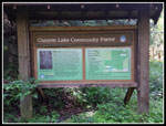
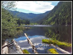
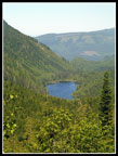
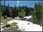
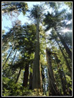
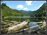
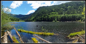
A signboard near the trailhead has lots of information along with a map of the trails. There is a two mile trail around the lake and the trails to the ridge top. The old road/trail goes up three miles to a junction. The road continues switchbacking up to the ridge. A real trail goes off at that point and in 1.1 miles it climbs through an old growth forest to the ridge. The forest starts at 3800'. The trees are big but not like the monsters that grow lower down. Less girth but still very impressive. After the signboard a short route drops to the lakeshore. It is a pretty lake but it has many old logs standing nearly vertically in it. Some checking online suggests that a landslide in the last 200 years dammed the creek and created the lake. The old forest along the creek is now underwater. My visit was before reading that and I was "stumped" as to why all the underwater trees.
From the lake I could also now see the distant ridge and snow well below the ridge top. I was not prepared for a long snow slog after all the miles to get to the trailhead. I was most interest in if I could get by the missing bridge and get high enough to see some of the old growth forest. With that in mind I headed up the trail. Immediately I reached one feature I was looking forward to. A big palm frond fossil. It has a wooden roof over it. This is the second palm fossil I have seen in the mountains. The first was on the shore of Lake Ivanhoe near Dutch Miller Gap. In .40 miles I came to the well signed trail junction. Right to the around the lake trail. Straight ahead to the old growth and ridge top. The signs do not agree. The online map says it is 4.1 miles to the ridge top via the old growth trail. The sign stated it is 2.5 miles to the old growth trail junction. My GPS agreed with the map. It is about 3 miles. That had me looking for the junction well before I reached it.
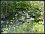
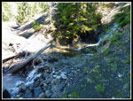
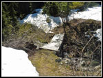
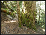
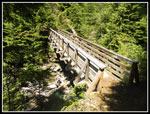
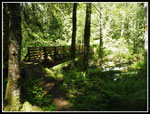
The trail starts at a moderate grade as it climbs the valley. All the bridges and culverts for the old road were removed when the road was decommissioned. I would guess I had about 20+ water crossings each way. Many are just easy climb down and step across and climb up. Half a dozen down low have bridges. One is quite impressive as it is high above the water. A few are low and small. A trip report said the first bridge was out. Then I came to the first and the second and the third bridges. All in fine shape. Only later did I come to the problem crossing. It is about 20 feet across and the water was running pretty fast. I deal breaker at peak snow melt time. Now the water was lower and some boards made for a pretty easy crossing. Water was not going to stop me. At least above freezing water.
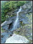
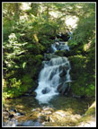
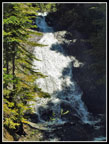
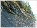
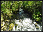
At about 3000' there was a little snow beside the trail. Not a good sign with 1400' still to climb. Then it was gone. I now came to a spot with slide alder on both sides of the old road/trail. A little reached onto the route but it could be pushed aside or gone around. It did not last long. At the long awaited first switchback the route become much more interesting. At the only meeting with Canyon Creek the route switched back to the left and climbed up a very steep slope. A road was blasted into the cliffy hillside. It is plenty wide. Mostly now covered with grasses and some small trees. I had seen a number of small waterfalls along the road and lower trail. Now the falls became the show. With bright sun overhead it was very difficult photograph them. Each of the many waterfall creeks had to be crossed. A number were wide enough to rock hop. Some small enough to jump. I had no idea there were so many waterfalls along this trail. I now had some views down to Canyon Lake too. One creek crossing required about a 7 foot drop straight down and up the other side.
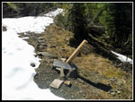
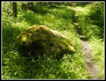
The waterfalls and creek crossings made for a long slow traverse. I was wondering if the route would ever switchback. Eventually it did. Near the switchback I saw some very unusual rocks. Dark rock inside a much lighter rock. A dark back rock like coal. I took photos and continued on. An older road continues on but the main route switched back to the left. Now I had to cross all those creeks again. There was even a wooden bridge this high up for one crossing. At about 3500' snow began to cover the road. It was getting very warm and where the snow covered creeks there were soft snow bridges. I could not imagine continuing all the way to the ridge under these conditions. At 3800' I came to the signed junction for the Old Growth Trail. Per the lower mileage sign I figured I had missed it and gone too far. The trail started on snow as it went right towards nearby forest. Once in the forest the snow went away. I had the first no road dirt trail of the day. I also had a whole forest of high elevation old growth trees. One major goal of the trip was reached.
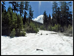
The trail lost elevation at first before starting to switchback uphill. As mentioned earlier, the trees are not 10 foot in diameter Douglas firs. They are Alaska Yellow Cedar, Pacific Silver Fir, and Mountain Hemlock that are 800 to 1,000 years old per the county park website. I walked over seven miles to reach this forest but it was worth it. Suddenly at 4000' patchy snow gave way to 3+ feet of it. Twice I postholed all the way to my crotch. Creeks under the snow had created voids. I was alone on a trail that might not see another person for weeks. I carry a personal locater beacon but I began to worry about the conditions. I was about .40 miles and 350' below the ridge top. My GPS map at home had trail on the map. The supposedly same map loaded onto the GPS unit did not have the trail. I lost it and could not find any sign of it with all the snow. An internal debate ended with my turning around. Live to hike another day. The views will be there on my next visit.
The hike down was not tough. The water crossings did get a little old though. I was glad to see the trailhead again. I took a short break on the shore before packing up to go. At the parking lot I decided on one more short jaunt. I went to the lake outlet to check out that bridge. It is a good sized one. Canyon Creek was running pretty high. Beyond the bridge is a mossy forest with some much larger trees. not old growth but pretty big nonetheless. Soon I headed back to the parking lot. Now I just had a 4.1 mile road walk. This is where a bike would have been nice. By the last few miles my feet were feeling the hard road. I was glad to see the gate again. There was a big truck angled in behind my car. I did not see a single person all day but someone was up there. It was not hard to turn around and soon I was zooming down the steep logging road. I arrived back at the car at 3:44 pm.
Over 7:39 I covered just under 16 miles with 3100' of elevation gain. As mentioned the solitude was deafening. I saw three deer, one mama grouse feigning a broken wing, and a big banana slug. More critters than people. To summarize, the lake and old growth forest are great. The trail is not badly overgrown but it is mostly an old road. This is not a destination hike for most people. Especially with the road gated. The shorter road is on private timber land so it will not be opened by the county parks folks. I will likely be back to check out the ridge top views at some point. Eventually, the main road will hopefully be repaired and a visit will be much less difficult. Until then it will be a pretty quiet place.
Click on thumbnails to get
larger pictures.
Trips - 2018
Home
I had pieced together another road option though it had very limited parking. One or two spots by the gate. It did cut the distance to the lake down to four miles with only about 1150' of elevation gain. Time to give it a try. It is a 105 mile drive from North Seattle and took almost two hours. Up Highway 9 to Highway 542 then across the NF Nooksack River and onto logging roads. My medium low clearance sedan had no trouble as with active logging the roads were in excellent shape. I'd hate to meet a logging truck on the road as it gains elevation very steeply to the gate. I arrived at the gate at 7:55 am. It would be a long day. I needed an early start. Yep, room for two cars to park off the edge of the road just before the gate. It would be challenging to fit a third. With two cars there, turning around would also be very challenging. The drop off the side of the road is nearly vertical. Maybe a 50 point turn could be done. Two feet forward, crank the wheel, then two feet back. Parked off the road, I had no problem turning around at the end of the day. Beware of trying this with the minimal parking situation.
My 8:05 am I was packed up and on my way. The gate is at 1200'. The trailhead at Canyon Lake is at 2350'. Most of the elevation gain is in the first two of four total miles of road. I chose to walk rather than bring a bike along. I had no idea about the road conditions. The road is smooth and hikes very fast. At the half mile mark I met the Canyon Lake Road that is washed out. There are several road junctions. Most have a green and white metal sign with an arrow. It points to the trailhead. If a road goes off steeply uphill or downhill do not take it. One uphill road is for active logging and is more heavily used but is not the correct route. Early on there are views down to the Nooksack River and out to forested peaks. Much of the road section is forested with no views. There were a lot of wildflowers along the road. Especially foxglove, buttercups, and daisies.
I made good time on the road arriving at the trailhead parking lot at 9:25 am. I had 4.1 miles done in 1:18 minutes. A little under 20 minutes per mile including a few stops. There is a burnt log from someone's fire in the middle of the parking lot but otherwise it's pretty clean. I was warned that the trail would be very overgrown after 9 years with little use or maintenance but I was pleasantly surprised to find it in pretty good shape. I brought a folding saw but I did not find a use for it. The main route to the ridge top is an old logging road. It has narrowed to a thin brown stripe in a ridiculously green setting. Grass, moss, evergreen trees, and new leaves on deciduous trees made for an amazing display of many shades of green.
A signboard near the trailhead has lots of information along with a map of the trails. There is a two mile trail around the lake and the trails to the ridge top. The old road/trail goes up three miles to a junction. The road continues switchbacking up to the ridge. A real trail goes off at that point and in 1.1 miles it climbs through an old growth forest to the ridge. The forest starts at 3800'. The trees are big but not like the monsters that grow lower down. Less girth but still very impressive. After the signboard a short route drops to the lakeshore. It is a pretty lake but it has many old logs standing nearly vertically in it. Some checking online suggests that a landslide in the last 200 years dammed the creek and created the lake. The old forest along the creek is now underwater. My visit was before reading that and I was "stumped" as to why all the underwater trees.
From the lake I could also now see the distant ridge and snow well below the ridge top. I was not prepared for a long snow slog after all the miles to get to the trailhead. I was most interest in if I could get by the missing bridge and get high enough to see some of the old growth forest. With that in mind I headed up the trail. Immediately I reached one feature I was looking forward to. A big palm frond fossil. It has a wooden roof over it. This is the second palm fossil I have seen in the mountains. The first was on the shore of Lake Ivanhoe near Dutch Miller Gap. In .40 miles I came to the well signed trail junction. Right to the around the lake trail. Straight ahead to the old growth and ridge top. The signs do not agree. The online map says it is 4.1 miles to the ridge top via the old growth trail. The sign stated it is 2.5 miles to the old growth trail junction. My GPS agreed with the map. It is about 3 miles. That had me looking for the junction well before I reached it.
The trail starts at a moderate grade as it climbs the valley. All the bridges and culverts for the old road were removed when the road was decommissioned. I would guess I had about 20+ water crossings each way. Many are just easy climb down and step across and climb up. Half a dozen down low have bridges. One is quite impressive as it is high above the water. A few are low and small. A trip report said the first bridge was out. Then I came to the first and the second and the third bridges. All in fine shape. Only later did I come to the problem crossing. It is about 20 feet across and the water was running pretty fast. I deal breaker at peak snow melt time. Now the water was lower and some boards made for a pretty easy crossing. Water was not going to stop me. At least above freezing water.
At about 3000' there was a little snow beside the trail. Not a good sign with 1400' still to climb. Then it was gone. I now came to a spot with slide alder on both sides of the old road/trail. A little reached onto the route but it could be pushed aside or gone around. It did not last long. At the long awaited first switchback the route become much more interesting. At the only meeting with Canyon Creek the route switched back to the left and climbed up a very steep slope. A road was blasted into the cliffy hillside. It is plenty wide. Mostly now covered with grasses and some small trees. I had seen a number of small waterfalls along the road and lower trail. Now the falls became the show. With bright sun overhead it was very difficult photograph them. Each of the many waterfall creeks had to be crossed. A number were wide enough to rock hop. Some small enough to jump. I had no idea there were so many waterfalls along this trail. I now had some views down to Canyon Lake too. One creek crossing required about a 7 foot drop straight down and up the other side.
The waterfalls and creek crossings made for a long slow traverse. I was wondering if the route would ever switchback. Eventually it did. Near the switchback I saw some very unusual rocks. Dark rock inside a much lighter rock. A dark back rock like coal. I took photos and continued on. An older road continues on but the main route switched back to the left. Now I had to cross all those creeks again. There was even a wooden bridge this high up for one crossing. At about 3500' snow began to cover the road. It was getting very warm and where the snow covered creeks there were soft snow bridges. I could not imagine continuing all the way to the ridge under these conditions. At 3800' I came to the signed junction for the Old Growth Trail. Per the lower mileage sign I figured I had missed it and gone too far. The trail started on snow as it went right towards nearby forest. Once in the forest the snow went away. I had the first no road dirt trail of the day. I also had a whole forest of high elevation old growth trees. One major goal of the trip was reached.
The trail lost elevation at first before starting to switchback uphill. As mentioned earlier, the trees are not 10 foot in diameter Douglas firs. They are Alaska Yellow Cedar, Pacific Silver Fir, and Mountain Hemlock that are 800 to 1,000 years old per the county park website. I walked over seven miles to reach this forest but it was worth it. Suddenly at 4000' patchy snow gave way to 3+ feet of it. Twice I postholed all the way to my crotch. Creeks under the snow had created voids. I was alone on a trail that might not see another person for weeks. I carry a personal locater beacon but I began to worry about the conditions. I was about .40 miles and 350' below the ridge top. My GPS map at home had trail on the map. The supposedly same map loaded onto the GPS unit did not have the trail. I lost it and could not find any sign of it with all the snow. An internal debate ended with my turning around. Live to hike another day. The views will be there on my next visit.
The hike down was not tough. The water crossings did get a little old though. I was glad to see the trailhead again. I took a short break on the shore before packing up to go. At the parking lot I decided on one more short jaunt. I went to the lake outlet to check out that bridge. It is a good sized one. Canyon Creek was running pretty high. Beyond the bridge is a mossy forest with some much larger trees. not old growth but pretty big nonetheless. Soon I headed back to the parking lot. Now I just had a 4.1 mile road walk. This is where a bike would have been nice. By the last few miles my feet were feeling the hard road. I was glad to see the gate again. There was a big truck angled in behind my car. I did not see a single person all day but someone was up there. It was not hard to turn around and soon I was zooming down the steep logging road. I arrived back at the car at 3:44 pm.
Over 7:39 I covered just under 16 miles with 3100' of elevation gain. As mentioned the solitude was deafening. I saw three deer, one mama grouse feigning a broken wing, and a big banana slug. More critters than people. To summarize, the lake and old growth forest are great. The trail is not badly overgrown but it is mostly an old road. This is not a destination hike for most people. Especially with the road gated. The shorter road is on private timber land so it will not be opened by the county parks folks. I will likely be back to check out the ridge top views at some point. Eventually, the main road will hopefully be repaired and a visit will be much less difficult. Until then it will be a pretty quiet place.
 View From Parking Spot |
 View Out From Road |
 Hiking The Road |
 Miles To Go |
 Green Sign |
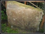
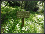
 Community Forest Sign |
 Parking Lot |
 Trailhead Signboard |
 View Up Lake |
 Palm Leaf Fossil |
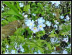 Forget-Me-Nots |
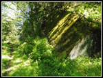 Big Mossy Rock |
 Trail Junction |
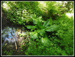 Skunk Cabbage |
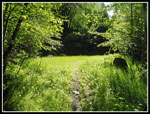 Sunny Green Meadow |
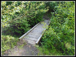 First Bridge |
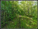 Narrow Brown Trail |
 Small Falls |
 Bridge Of Sorts |
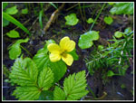 Yellow Violet |
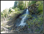 Bigger Waterfall |
 Another Falls |
 Look Back To Lake |
 Another Creek To Cross |
 Trail Marker |
 Snow Begins |
 Bent Bridge |
 Off & On Snow |
 Broken Trail Sign |
 Old Growth Forest |
 Pole For Scale |
 Looking Up |
 Smooth Water |
 Huckleberry |
 More Snow Up Higher |
 Steep Drop To Cross |
 Grassy Route |
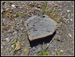 Bi Colored Rock |
 Yet Another Waterfall |
 Rock Layers |
 Biggest Waterfall |
 Encroaching |
 Trillium |
 Spring Beauty |
 Big Bridge |
 Lush Green Forest |
 Very Mossy Rock |
 Outlet Creek |
 Canyon Lake View |
 Outlet Bridge |
 Back At The Gate |
 Canyon Lake Panorama |
Trips - 2018
Home