1-28-18
Yet
another stormy windy weekend day. The day before I hiked on Cougar
Mountain and right near the end a large branch came crashing down. It
was not close but it was enough to spook me. For Sunday I chose another
close in hike on the opposite side of Tiger Mt. from the expected wind
direction. It rained while driving from High Point on I-90 to within a
mile of the trailhead at Tiger Summit off Highway 18. Then it stopped.
Amazingly, it stopped for almost the entire time I was hiking.
Nonetheless. I started out with a rain jacket and rain pants on. I
packed up and was on the trail by about 8:10 am. Right at the start of
the Connector Trail five bikes blasted on by me. They were the last
folks I saw until I was one third of the way down. Hours of total
solitude on Tiger. I crossed the main road and headed onto
the NW Timber Trail. Quickly I headed uphill on the Master Link Trail.
It is a mountain bike trail but they can only go uphill on it.
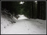
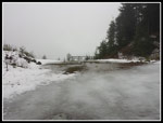
Though the sun was up it was misty and dark in the forest. Not headlamp dark but dark for 8:30 am. The trail is very gently graded and switches back and forth to slowly gain elevation. We had lots of rain the past few days and I was curious whether I would get into snow or not. East Tiger is the same elevation as Snoqualmie Pass but being so much closer to salt water it has much less snow. The temperature was in the low 40s. It stayed there all day. I usually expect to have two or three groups of bikers pass me on this trail. Not this day. I passed the Inside Passage Trail and soon reached the big bridge. At that point there was a little snow on the side of the trail.
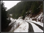
The part above the bridge always takes longer than I expect. It was no different this day. The trail became wetter as slushy snow began. I had on a new pair of heavier boots for winter and I was glad to have a chance to test their waterproofness. They did great. When I popped out on the road there was now enough snow to entirely cover the road. I was tempted to hike right up the road but I wanted a full 8 miles so I crossed the road and picked up the Quick Link Trail. The quick link is gently graded but longer than the road walk. Even in the trees there was now enough snow to be slick. I expected to use my umbrella much of the day so I did not bring trekking poles. With the gentle grade I was fine. The Quick Link brought me back to the road once again. There was a good 3 - 5 inches of snow on the road. No problem to walk in but much slower than if snow free.
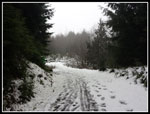
There were a few bike tracks in the snow and a few boot tracks. The road climbs up to a high point then drops a little to the junction with the East Tiger Summit Road. Here I turned right and started the last .70 mile climb to the top. Now I had just one set of footprints in the snow. One set up and none coming down. I'm 6'4" tall with long legs. I'm not used to not being able to walk in someone else's tracks. The other person must have a 40" inseam. Try as I might I had to nearly jump to stay in his tracks. I quickly gave up and had to make my own track. That was definitely slower. With fresh snow and only the one set of tracks it was a very pretty winter scene. Pretty is not a word often used to describe the road to the summit. Last time I was up there I met two deer walking down the road. This day I was totally alone.
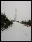
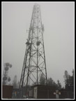
It is really strange to not see even one person on a bike on East Tiger. Maybe the snow kept them from the last road to the top. When I reached the East Tiger Trail crossing I saw that the tracks I had been following went left on the trail to the summit. I also saw one pair of tracks coming down the road then down the trail. It looked like I would be the only person on top. I just had a short steep slog to the top now. I had heard some loud wind at times high up on my ascent. I was prepared to find the top very windy. It was not to be. Thankfully, the wind was holding off. I did get a short bit of sleet/rain on the final road but it only lasted a short time. It was the only time I took out the umbrella all day.
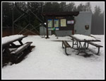
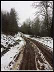
I arrived on top at 10:04 am. With the snow I took 1:54 to come up. Not a great time but not too bad considering the conditions. I usually sit at the picnic tables and have lunch. This day My stay was about five minutes tops and I was on my way down. There was no view out through the clouds but I could see the tops of the towers. Downhill was much easier. Much softer on my knees than the hard packed gravel road. Down at the road junction I chose to head back via the road. Before the new bike trails the road was my only route up and down. Now it allows a loop trip. A truck had been up to the junction recently. It did not go farther. It also had left wide tracks of bare dirt with 4-6 inches of snow elsewhere on the road. Bare dirt sounded fine instead of the slick slushy snow for my descent.
I dropped to the next junction and turned left and back to the bottom. There have been mile markers every half mile for decades on the road. Often several of them are missing. Now they are all there. The half and one mile markers had been missing for many years. Just above the two mile marker I met two guys coming up. The first people I saw since near the start of my trip. I saw another 4 or 5 small groups also hiking up. That was it for the day. Pretty close to total solitude on some very busy trails. When I reached the parking lot it was about half full at most.
I had hoped to get in a full 8 miles if the wind did not force me to abort before the top. I expected to use my umbrella most of the day as I had the day before. Instead, I had only a short spit of rain and the wind never did blow hard. Most of the trip was on bare dirt. The upper part was on fresh snow that coved the road with a white coat. The lack of a slew of footprints made it much more scenic. All in all, it was as much better hike than I planned. Sometimes things just work out.
Click on thumbnails to get
larger pictures.
Trips - 2018
Home
Though the sun was up it was misty and dark in the forest. Not headlamp dark but dark for 8:30 am. The trail is very gently graded and switches back and forth to slowly gain elevation. We had lots of rain the past few days and I was curious whether I would get into snow or not. East Tiger is the same elevation as Snoqualmie Pass but being so much closer to salt water it has much less snow. The temperature was in the low 40s. It stayed there all day. I usually expect to have two or three groups of bikers pass me on this trail. Not this day. I passed the Inside Passage Trail and soon reached the big bridge. At that point there was a little snow on the side of the trail.
The part above the bridge always takes longer than I expect. It was no different this day. The trail became wetter as slushy snow began. I had on a new pair of heavier boots for winter and I was glad to have a chance to test their waterproofness. They did great. When I popped out on the road there was now enough snow to entirely cover the road. I was tempted to hike right up the road but I wanted a full 8 miles so I crossed the road and picked up the Quick Link Trail. The quick link is gently graded but longer than the road walk. Even in the trees there was now enough snow to be slick. I expected to use my umbrella much of the day so I did not bring trekking poles. With the gentle grade I was fine. The Quick Link brought me back to the road once again. There was a good 3 - 5 inches of snow on the road. No problem to walk in but much slower than if snow free.
There were a few bike tracks in the snow and a few boot tracks. The road climbs up to a high point then drops a little to the junction with the East Tiger Summit Road. Here I turned right and started the last .70 mile climb to the top. Now I had just one set of footprints in the snow. One set up and none coming down. I'm 6'4" tall with long legs. I'm not used to not being able to walk in someone else's tracks. The other person must have a 40" inseam. Try as I might I had to nearly jump to stay in his tracks. I quickly gave up and had to make my own track. That was definitely slower. With fresh snow and only the one set of tracks it was a very pretty winter scene. Pretty is not a word often used to describe the road to the summit. Last time I was up there I met two deer walking down the road. This day I was totally alone.
It is really strange to not see even one person on a bike on East Tiger. Maybe the snow kept them from the last road to the top. When I reached the East Tiger Trail crossing I saw that the tracks I had been following went left on the trail to the summit. I also saw one pair of tracks coming down the road then down the trail. It looked like I would be the only person on top. I just had a short steep slog to the top now. I had heard some loud wind at times high up on my ascent. I was prepared to find the top very windy. It was not to be. Thankfully, the wind was holding off. I did get a short bit of sleet/rain on the final road but it only lasted a short time. It was the only time I took out the umbrella all day.
I arrived on top at 10:04 am. With the snow I took 1:54 to come up. Not a great time but not too bad considering the conditions. I usually sit at the picnic tables and have lunch. This day My stay was about five minutes tops and I was on my way down. There was no view out through the clouds but I could see the tops of the towers. Downhill was much easier. Much softer on my knees than the hard packed gravel road. Down at the road junction I chose to head back via the road. Before the new bike trails the road was my only route up and down. Now it allows a loop trip. A truck had been up to the junction recently. It did not go farther. It also had left wide tracks of bare dirt with 4-6 inches of snow elsewhere on the road. Bare dirt sounded fine instead of the slick slushy snow for my descent.
I dropped to the next junction and turned left and back to the bottom. There have been mile markers every half mile for decades on the road. Often several of them are missing. Now they are all there. The half and one mile markers had been missing for many years. Just above the two mile marker I met two guys coming up. The first people I saw since near the start of my trip. I saw another 4 or 5 small groups also hiking up. That was it for the day. Pretty close to total solitude on some very busy trails. When I reached the parking lot it was about half full at most.
I had hoped to get in a full 8 miles if the wind did not force me to abort before the top. I expected to use my umbrella most of the day as I had the day before. Instead, I had only a short spit of rain and the wind never did blow hard. Most of the trip was on bare dirt. The upper part was on fresh snow that coved the road with a white coat. The lack of a slew of footprints made it much more scenic. All in all, it was as much better hike than I planned. Sometimes things just work out.
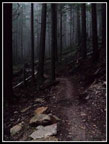 Dark In The Forest |
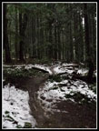 Into Snow |
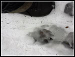 Paw Print |
 On The Road |
 One Set Of Prints |
 Summit Tower |
 Snow On Tables |
 Cloudy Sky |
 Icy Ground |
 Bare Tracks |
 Muddy Road Spot |
 Waterfall |
Trips - 2018
Home