1-05-19
For
my first hike of 2019 I headed
north towards Bellingham to Blanchard Hill. Avalanche danger was high
in the mountains and I was getting tired of I-90 trails. I was on the
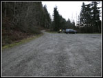
road at 7:00 am and it was still dark. Exit at Alger and I arrived at
the Blanchard Hill Upper Trailhead at 8:16 am. I brought an umbrella.
It looked like there would be some short showers but a mostly dry day.
It turned out better than that. I chose to head up the road
and finish via the Lily Lake Trail. There was one truck in the lot so I
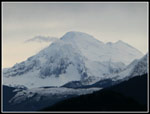
expected some solitude on the way up. Across from the gravel pit is a
view down to the valley below and east to Mt. Baker. The sky was white
to the east but Baker was mostly clear. A better view than I expected.
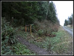
I left the road on the Alternate Incline Trail.
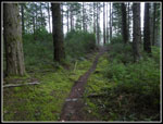
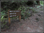
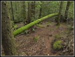
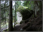
The old Incline Trail is now hard to find. I couldn't even see the "This Is Not A Trail" sign. I guess it is lost to history. It was cold but not frigid. There was even a little blue sky above. I climbed up to the junction with the Pacific Northwest Trail (PNT). Last year Gary, John, and I explored a bike trail that leaves from near the junction. This year the start of that unofficial trail has been rebuilt. Real trail at the beginning. I followed it about half a mile. I recalled some very good mountain views last year from a clear cut. I did not get there in half a mile. The road I was now on was dropping fast so I turned around and headed back. At the PNT junction I turned left on the old railroad grade. I would be back to redo this section later in the day. I reached the top of the Lily Lake Trail and continued on to Max's Shortcut. That is the route of the PNT. I went straight and left the PNT. The trail to Lily Lake appeared soon after. I kept going straight on my way to Oyster Dome.
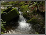
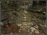
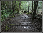
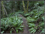
The route drops along a small creek. The old rock hop creek crossing has had a bridge for several years. Now it is a very easy crossing. by the bridge I met the first person of the day. Then I saw three more and then another person. That was it until I reached the junction with the Oyster Dome Trail. That junction had been signless for a number of years. I rerouted a number of folks over those years who did not know where to go. The trail drops to cross the creek. That was always a fairly wide rock hop. Higher water made it challenging to keep dry feet. Not any more. Now there are a number of big flat rocks allowing for an easy crossing with dry feet. I wore heavier waterproof boots but all the usual wet spots were not a problem, even after a rainy period.
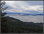
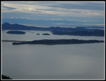
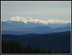
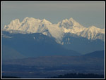
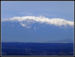
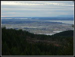
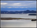
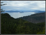
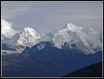
I passed a number of folks going up and down on the way to Oyster Dome. That was not at all surprising. I arrived at the Dome to find only four or five folks there. Not the crowd I expected. It was 10:26 am when I arrived. Views out were pretty good. The sky was mostly white but visibility was good. The Olympic Mountains were in and out of clouds. I stopped for photos and a food break then headed over to the real summit of Oyster Dome. I could just see North Butte where I would be later in the day. To the north I could see snowy peaks with some sunshine lighting up the peaks. With a 30x zoom lens the peaks looked pretty close by. I then headed back to the next lower view point at the Dome. The view to the southwest was great.
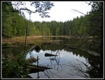
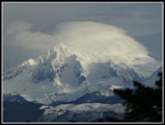
Now it was time to head back. Lots of folks were now coming up. Probably 80% of the people I saw all day were in that short .70 mile section of the Oyster Dome Trail. At the Oyster Dome junction I headed back towards Lily lake leaving the crowds behind. At the junction with the Lily Lake Trail I turned left and quickly reached the lake. The two folks seen here were the only people seen until I reached Lizard Lake. Nice views from the outlet of Lily Lake. Back on trail I walked along the lakeshore then climbed up to North Butte. Last January we had a crowd on the summit. This time I was the only person there. Nice views on top. I had the rest of my lunch and went over to the north viewpoint. Trees are closing out the view of Mt. Baker but it is still pretty good. The view had changed a lot since my morning look at the mountain. Now the summit was encased in a big white cloud cap. Bad weather was coming and the lenticular cloud was proof.
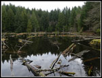
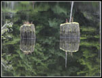
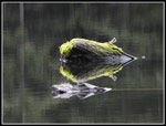
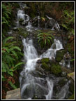
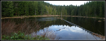
I now headed downhill and turned left on the trail to Lizard Lake. This was just a minimal boot path until four or five years ago when a real trail was put in. It did not take long to reach the lake. I went along the shore until the spot where the old trail fell into the lake. The trail now goes up above this spot. It does give great views of the lake. Lots of stumps and logs that made for some very interesting reflection shots this day. The waterfall that drops then crosses the trail was running pretty fast this day. More photos. It is only a couple minute walk from the lake back to the junction of the Alternate Incline Trail and the PNT that I was now on. That closed one loop. I followed the railroad grade for th second time to the top of the Lily Lake Trail.
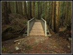
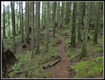
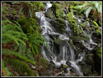
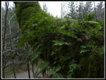
The Lily Lake Trail would take me back to the trailhead. This would be the second loop of the day. The trail is in very good condition. It is a biker and hiker trail and can get a little muddy. Not so far this winter. The trail is nicely graded and hikes pretty fast. I met a few hikers still coming up and a few bikers going down. Near the bottom is a bridge next to a small but steep waterfall. As always, I stopped for more photos. I reached the end of the trail at 1:35 pm. The parking lot is about a four minute walk up the road. Now the lot was mostly full. A good crowd but not overflowing. This was the earliest I have ever finished this trip. I was home well ahead of the Seahawks - Cowboys playoff game. Unfortunately, the Seahawks lost.
This is a favorite lower elevation winter trip for me. I have hiked it on snow but most winters it is snow free most of the time. My usual route is 10 mile with 2100' of gain. My detour on the bike trail brought me day up to 11 miles with 2300' of gain. It is 75 miles from my home in North Seattle but with traffic moving at the speed limit it is only about 75 minutes one way. This day traffic was light in both directions. In spring there are a variety of wildflowers including a great display of skunk cabbage. This day I was just happy to see the views, the lakes, and the forest. There were plans to log much of Blanchard Hill including Oyster Dome Last year a plan was funded to remove that threat. I am pleased that this hike will remain forested into the future.
Click on thumbnails to get
larger pictures.
Trips - 2019
Home
The old Incline Trail is now hard to find. I couldn't even see the "This Is Not A Trail" sign. I guess it is lost to history. It was cold but not frigid. There was even a little blue sky above. I climbed up to the junction with the Pacific Northwest Trail (PNT). Last year Gary, John, and I explored a bike trail that leaves from near the junction. This year the start of that unofficial trail has been rebuilt. Real trail at the beginning. I followed it about half a mile. I recalled some very good mountain views last year from a clear cut. I did not get there in half a mile. The road I was now on was dropping fast so I turned around and headed back. At the PNT junction I turned left on the old railroad grade. I would be back to redo this section later in the day. I reached the top of the Lily Lake Trail and continued on to Max's Shortcut. That is the route of the PNT. I went straight and left the PNT. The trail to Lily Lake appeared soon after. I kept going straight on my way to Oyster Dome.
The route drops along a small creek. The old rock hop creek crossing has had a bridge for several years. Now it is a very easy crossing. by the bridge I met the first person of the day. Then I saw three more and then another person. That was it until I reached the junction with the Oyster Dome Trail. That junction had been signless for a number of years. I rerouted a number of folks over those years who did not know where to go. The trail drops to cross the creek. That was always a fairly wide rock hop. Higher water made it challenging to keep dry feet. Not any more. Now there are a number of big flat rocks allowing for an easy crossing with dry feet. I wore heavier waterproof boots but all the usual wet spots were not a problem, even after a rainy period.
I passed a number of folks going up and down on the way to Oyster Dome. That was not at all surprising. I arrived at the Dome to find only four or five folks there. Not the crowd I expected. It was 10:26 am when I arrived. Views out were pretty good. The sky was mostly white but visibility was good. The Olympic Mountains were in and out of clouds. I stopped for photos and a food break then headed over to the real summit of Oyster Dome. I could just see North Butte where I would be later in the day. To the north I could see snowy peaks with some sunshine lighting up the peaks. With a 30x zoom lens the peaks looked pretty close by. I then headed back to the next lower view point at the Dome. The view to the southwest was great.
Now it was time to head back. Lots of folks were now coming up. Probably 80% of the people I saw all day were in that short .70 mile section of the Oyster Dome Trail. At the Oyster Dome junction I headed back towards Lily lake leaving the crowds behind. At the junction with the Lily Lake Trail I turned left and quickly reached the lake. The two folks seen here were the only people seen until I reached Lizard Lake. Nice views from the outlet of Lily Lake. Back on trail I walked along the lakeshore then climbed up to North Butte. Last January we had a crowd on the summit. This time I was the only person there. Nice views on top. I had the rest of my lunch and went over to the north viewpoint. Trees are closing out the view of Mt. Baker but it is still pretty good. The view had changed a lot since my morning look at the mountain. Now the summit was encased in a big white cloud cap. Bad weather was coming and the lenticular cloud was proof.
I now headed downhill and turned left on the trail to Lizard Lake. This was just a minimal boot path until four or five years ago when a real trail was put in. It did not take long to reach the lake. I went along the shore until the spot where the old trail fell into the lake. The trail now goes up above this spot. It does give great views of the lake. Lots of stumps and logs that made for some very interesting reflection shots this day. The waterfall that drops then crosses the trail was running pretty fast this day. More photos. It is only a couple minute walk from the lake back to the junction of the Alternate Incline Trail and the PNT that I was now on. That closed one loop. I followed the railroad grade for th second time to the top of the Lily Lake Trail.
The Lily Lake Trail would take me back to the trailhead. This would be the second loop of the day. The trail is in very good condition. It is a biker and hiker trail and can get a little muddy. Not so far this winter. The trail is nicely graded and hikes pretty fast. I met a few hikers still coming up and a few bikers going down. Near the bottom is a bridge next to a small but steep waterfall. As always, I stopped for more photos. I reached the end of the trail at 1:35 pm. The parking lot is about a four minute walk up the road. Now the lot was mostly full. A good crowd but not overflowing. This was the earliest I have ever finished this trip. I was home well ahead of the Seahawks - Cowboys playoff game. Unfortunately, the Seahawks lost.
This is a favorite lower elevation winter trip for me. I have hiked it on snow but most winters it is snow free most of the time. My usual route is 10 mile with 2100' of gain. My detour on the bike trail brought me day up to 11 miles with 2300' of gain. It is 75 miles from my home in North Seattle but with traffic moving at the speed limit it is only about 75 minutes one way. This day traffic was light in both directions. In spring there are a variety of wildflowers including a great display of skunk cabbage. This day I was just happy to see the views, the lakes, and the forest. There were plans to log much of Blanchard Hill including Oyster Dome Last year a plan was funded to remove that threat. I am pleased that this hike will remain forested into the future.
 Parking Lot |
 Morning Mt. Baker |
 Start Of Trail |
 Logging Gear |
 Bike Trail |
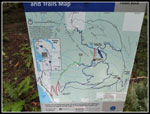 Trail Map |
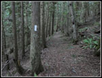 PNT Marker |
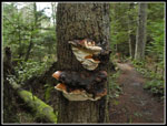 Fungi |
 Small Cascade |
 New Bridge |
 New Creek Steps |
 Oyster Dome Trail |
 Oyster Dome View |
 Islands In The Sound |
 North Butte Above |
 Northern Mountains |
 Zoom Of Peaks |
 Sunlit Mountains |
 View South Of Dome |
 Refinery & Mountains |
 Muddy Trail |
 Trail Signs |
 Lily Lake |
 North Butte View |
 Mossy Log |
 Twin Sisters |
 Baker Cloud Cap |
 Trail To Lizard Lake |
 Waterfall |
 Lizard Lake |
 Reflection I |
 Reflection II |
 Big Rock |
 Lily Lake Trail |
 Final Falls |
 Moss & Ferns |
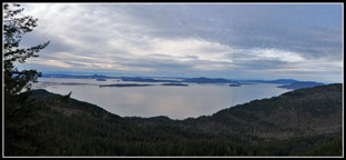 Oyster Dome Panorama View |
 Lily Lake Panorama |
Trips - 2019
Home