1-26-19
After
snowshoe trips the past two
weekends I was looking for a trip back on dirt trails. I chose a trip
north to Chuckanut Mountain. I like this small mountain not far from
salt water. The North Chuckanut Trailhead is at the northwest corner of
the mountain. It is 83 miles from my home in North Seattle and with
light morning traffic takes about 1:25 minutes to drive. I was on the
road by 7:07 am and arrived at 8:30 am. I expected to find half a dozen
cars in the lot. The lot and overflow parking along the road were
almost full. There was a crowd of people in a circle. It turns out
there was a big volunteer work parking getting ready to go to work.
There must have been 20 folks at least. Last year I arrived to find the
biggest running race of the year on the mountain. I had to improvise
another trip. This year I arrived just early enough to find a parking
spot. The trailhead is 105' above sea level. That is starting a
mountain hike low. By 8:36 I was on the trail.
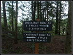
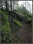
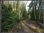
There are several boardwalk bridges near the start. On has recently been replaced. It abuts and older one and is several inches higher. They will need to add a small ramp to keep folks from tripping there. The route quickly reaches the old Interurban railroad grade. My route turned left on the grade. A mossy cement pier marks where a train trestle has been missing for a long time. The route is now off the grade as it heads for Arroyo Park. Many junctions have maps that show where you are now. Unfortunately, the one at the next junction is way to high for me at 6'4". I'd need a step ladder to read it clearly. All the rest of the maps at junctions are easy to read. I headed off on the North Lost Lake Trail as it began to climb. This part of the trail has been improved for mountain bikes. The switchbacks are wide and banked a bit. The grade is steady but fairly moderately steep.
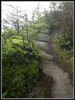
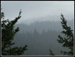
There are a lot of junctions. Most are will signed. A map is very useful until you memorize all the trails. The trail is soon on an old road. The road is wider and has a very steady grade. At the junction for the Ridge Trail I turned right on that trail. This junction is where my loop started and ended. The ridge trail quickly climbs to the crest of the ridge. It spends about 3 miles on the crest as the ridge climbs with many ups and downs. The forecast was for a little morning fog then sunshine. I was hoping by the time I reached the ridge top I would be above the fog and looking at snow covered peaks. I especially hoped that Mt. Baker would be in the clear. No such luck. I waited at the first viewpoint for a while and a little sun did shine through but I have had any longer views.
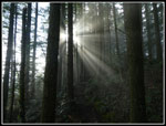
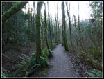
I always forget just how long the ridge is and how many ups and downs there are. And I did once again. I saw several groups of young women runners along the ridge. Lots of college age folks at the home of Western Washington University. I also saw one mountain biker. There is a trail that drops down to Cleator Road before the ridge gets a little scambly. The trail is really on the ridge crest in most places. It drops almost vertically to the east and just very steeply to the west. The ridge is one of the best parts of the trip. It is also forested. There are a few windows out to the east but no views in other directions.
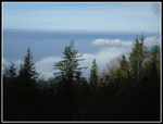
I finally reached the spot where the ridge meets Cleator Road. The trail climbs to the summit just ahead and above Cyrus Gates Overlook but it is completely forested. I walked the last short bit of road to the overlook. There were lots of cars in the lot and several mountain bikers. There is a bit of a view out towards the San Juan Islands but clouds kept some of the views hidden. I arrived at 11:15 am. I took 2:39 to hike about 5 miles. There were a lot of photo breaks and the ridge break while I hoped the sky would clear. After lunch I was back on my way at 11:30 am.
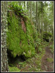
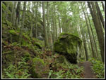
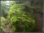
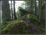
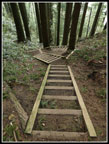
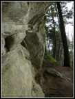
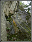
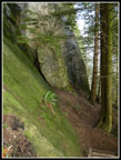
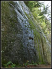
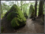
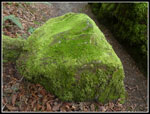
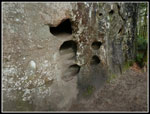
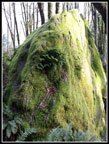
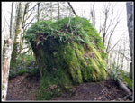
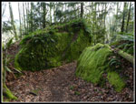
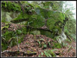
Now came my favorite part of the trip. The Rock Trail was finished early in 2014. My first visit was a year later. A short trail from the overlook leads to the start of the drop. And it is quite a drop. The first part is on wooden staircases that seem to drop almost vertically. Soon it turns into a narrow trail that hugs the steep slope. Then comes the sandstone cliffs. They look like they should be in Utah or Arizona not on a mountain along the Pacific coast. In places the cliffs overhang the trail. The 1.2 miles of the Rock Trail are always the slowest part of the trip. I can count on half my day's photos being along here. This day was no exception. Farther down the slope moderates. Chucks of big rocks have fallen off and fallen. They are mostly covered with bright green moss. Some are tall and narrow. Some are more rounded. All of them are a sight to see. It was 12:10 pm when I reached the junction with the Lost Lake Trail.
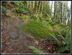
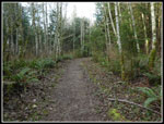
Now I sped up. The trail is mostly on old road bed and is smooth with minimal elevation change. Perfect for some fast hiking. At the turn off for Lost Lake I turned right on the short trail. The lake is long and narrow. I went off trail a short ways to the shore near the outlet. I had to push through branches to get to a viewpoint of the lake. I spooked a Great Blue Heron that flew away before I could get a photo. My break was short and I headed back to the North Lost Lake Trail. Two big groups were now just ahead of me on the lake spur trail. Thankfully they stopped at the junction and I was able to pass about 18 folks. They represented almost half the people I saw all day. In a few minutes they were gone. This trail is right below the Ridge Trail I had hiked on the way in. The slope is almost vertical. The trail is high above but not very far away. I closed the loop at the junction with the Ridge Trail. Now I just had to retrace my route coming in.
I saw a few runners and a couple hikers but there was not much of a crowd on a unusually dry and warm January day. I made it back to the trailhead at 2:14 pm. For the day I hiked about 11.5 miles with 2700' of gain. Quite a bit of gain for a trail with a high point of 1820'. Did I mention all the ups and downs on the ridge? I was able to drive home and arrive well before darkness. For a low mountain near salt water just outside of a city this is a great trip.
Click on thumbnails to get
larger pictures.
Trips - 2019
Home
There are several boardwalk bridges near the start. On has recently been replaced. It abuts and older one and is several inches higher. They will need to add a small ramp to keep folks from tripping there. The route quickly reaches the old Interurban railroad grade. My route turned left on the grade. A mossy cement pier marks where a train trestle has been missing for a long time. The route is now off the grade as it heads for Arroyo Park. Many junctions have maps that show where you are now. Unfortunately, the one at the next junction is way to high for me at 6'4". I'd need a step ladder to read it clearly. All the rest of the maps at junctions are easy to read. I headed off on the North Lost Lake Trail as it began to climb. This part of the trail has been improved for mountain bikes. The switchbacks are wide and banked a bit. The grade is steady but fairly moderately steep.
There are a lot of junctions. Most are will signed. A map is very useful until you memorize all the trails. The trail is soon on an old road. The road is wider and has a very steady grade. At the junction for the Ridge Trail I turned right on that trail. This junction is where my loop started and ended. The ridge trail quickly climbs to the crest of the ridge. It spends about 3 miles on the crest as the ridge climbs with many ups and downs. The forecast was for a little morning fog then sunshine. I was hoping by the time I reached the ridge top I would be above the fog and looking at snow covered peaks. I especially hoped that Mt. Baker would be in the clear. No such luck. I waited at the first viewpoint for a while and a little sun did shine through but I have had any longer views.
I always forget just how long the ridge is and how many ups and downs there are. And I did once again. I saw several groups of young women runners along the ridge. Lots of college age folks at the home of Western Washington University. I also saw one mountain biker. There is a trail that drops down to Cleator Road before the ridge gets a little scambly. The trail is really on the ridge crest in most places. It drops almost vertically to the east and just very steeply to the west. The ridge is one of the best parts of the trip. It is also forested. There are a few windows out to the east but no views in other directions.
I finally reached the spot where the ridge meets Cleator Road. The trail climbs to the summit just ahead and above Cyrus Gates Overlook but it is completely forested. I walked the last short bit of road to the overlook. There were lots of cars in the lot and several mountain bikers. There is a bit of a view out towards the San Juan Islands but clouds kept some of the views hidden. I arrived at 11:15 am. I took 2:39 to hike about 5 miles. There were a lot of photo breaks and the ridge break while I hoped the sky would clear. After lunch I was back on my way at 11:30 am.
Now came my favorite part of the trip. The Rock Trail was finished early in 2014. My first visit was a year later. A short trail from the overlook leads to the start of the drop. And it is quite a drop. The first part is on wooden staircases that seem to drop almost vertically. Soon it turns into a narrow trail that hugs the steep slope. Then comes the sandstone cliffs. They look like they should be in Utah or Arizona not on a mountain along the Pacific coast. In places the cliffs overhang the trail. The 1.2 miles of the Rock Trail are always the slowest part of the trip. I can count on half my day's photos being along here. This day was no exception. Farther down the slope moderates. Chucks of big rocks have fallen off and fallen. They are mostly covered with bright green moss. Some are tall and narrow. Some are more rounded. All of them are a sight to see. It was 12:10 pm when I reached the junction with the Lost Lake Trail.
Now I sped up. The trail is mostly on old road bed and is smooth with minimal elevation change. Perfect for some fast hiking. At the turn off for Lost Lake I turned right on the short trail. The lake is long and narrow. I went off trail a short ways to the shore near the outlet. I had to push through branches to get to a viewpoint of the lake. I spooked a Great Blue Heron that flew away before I could get a photo. My break was short and I headed back to the North Lost Lake Trail. Two big groups were now just ahead of me on the lake spur trail. Thankfully they stopped at the junction and I was able to pass about 18 folks. They represented almost half the people I saw all day. In a few minutes they were gone. This trail is right below the Ridge Trail I had hiked on the way in. The slope is almost vertical. The trail is high above but not very far away. I closed the loop at the junction with the Ridge Trail. Now I just had to retrace my route coming in.
I saw a few runners and a couple hikers but there was not much of a crowd on a unusually dry and warm January day. I made it back to the trailhead at 2:14 pm. For the day I hiked about 11.5 miles with 2700' of gain. Quite a bit of gain for a trail with a high point of 1820'. Did I mention all the ups and downs on the ridge? I was able to drive home and arrive well before darkness. For a low mountain near salt water just outside of a city this is a great trip.
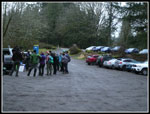 Crowded Parking Lot |
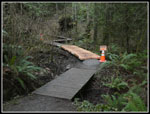 New Boardwalk |
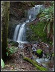 Nice Waterfall |
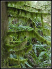
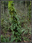 Ferny Tree |
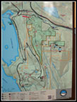 Trail Map |
 Ridge Trail Rock |
 More Rocks |
 Trail On Ridge Top |
 Mossy Rock |
 Cloudy Ridges |
 Good Signage |
 Short Scramble |
 Trail Through Rocks |
 Wow! |
 Cyrus Gates Overlook |
 Steep Staircase |
 Sandstone |
 Colors On Rock |
 Mossy Sandstone |
 Wet Rock |
 Favorite Place |
 Hey, A Mossy Rock! |
 Rock Pockets |
 Lower Rock Trail |
 Tall Rock |
 Bad Haircut? |
 Trail Between Rocks |
 On N. Lost Lake Trail |
 Very Mossy Limbs |
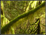 Great Mossy Color |
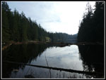 Lost Lake |
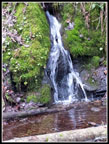 Small Waterfall |
 Last Green Rock |
 Now On Old Road |
 Interurban Trail |
Trips - 2019
Home